Cycling the Otago Rail Trail and ending onn the railway to Dunedin
The Otago Rail Trail is well known in New Zealand. Normally it is suggested to take four or five days stopping at bed and breakfast places along the way, but we had only two days to complete the 151km ride.
Schedule
Our ride descriptions give an account of the ride that we completed. As part of the description we also provide links to Wikiloc or Google maps and elevation profiles based on mapping data available through the internet. The ride profiles are smoothed to give what in our opinion is a more beneficial view of the profile. We use paper maps, GPS and on line data to plan and conduct our rides. We are happy for you to use our descriptions, but be aware that we do not guarantee the accuracy of the information provided as situations surrounding any ride change over time.
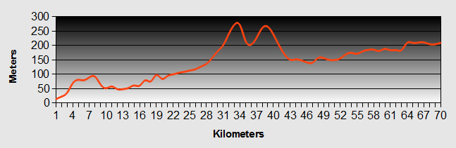
Otago - Day 1 - Arrowtown to Clyde
- Distance 70.6km
- Max Elevation 410m
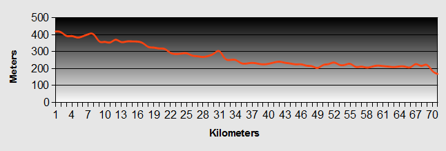
Otago - Arrowtown to Clyde Ride Profile
Ride Description
From Arrowtown the ride was downhill to join SH6. As we turned in the direction of Cromwell, we looked up to see the steep hairpins, winding their way up the hillside towards Crown Range, which we had ridden down on our way to Queenstown. Continuing downhill, the road follows the Gibston River valley and we spotted the first of several vineyards, looking very Spanish with unusual (for New Zealand) white washed walls and pan tiled roofs. Crossing over the river we stopped to view the bungy platform on the old road bridge. This is famous as the first commercial bungy jump in New Zealand.


The valley broadened out as we passed more wineries. This particular lady had obviously been enjoying the Pinot Gris.
Following the valley, the white water roaring and foaming below us, we dropped down into the Kawarau Gorge. The wind was speeding us onwards, but as the narrow gorge twisted and turned through the hills, we occasionally got caught in violent sideways and head on gusts.


Coming out of the gorge the land became more agricultural with lots of fruit orchards, on the outskirts of Cromwell, lying at the head of Lake Dunstan. When the Clyde dam was built, forming this lake, the original town was submerged and a new town was built. Some of the original, historic buildings were relocated onto the shores of the lake and are now preserved as a working museum of times gone by. We stopped and ate lunch there, overlooking the water.
The lake stretches along the river valley from Cromwell to Clyde where the Otago Rail Trail starts from. It is the longest man-made lake in New Zealand.


We followed the road along the side of the lake arriving at the dam and hydro-generating station, which provides over 30% of New Zealand's electricity. It is built close to two fault lines. The design comprises two concrete sides to the dam, divided by a sliding steel wedge allowing the dam to undergo a vertical displacement of up to 6 meters. The residents of Clyde, sitting well below the dam water level, will hope that this design works in the event of an earthquake.
Clyde is a quaint town with a few well preserved buildings on the main street. It lies at the start of the Otago Rail Trail. We had planned to ride the Otago trail on our way to Dunedin and then get the train through the famous Taieri gorge. As the train only runs twice a week, on Friday and Sunday, we had to cover the 151km in two days to be able to take the Friday train.

As we left the supermarket, a local lady, seeing our bicycles, asked us if we were doing the Otago Rail Trail ride. She wanted to know our views on the plans to tarmac the surface. Our reply that it was a good idea did not please her as she was dead against it. When we told her that many of the old railway routes in Britain were tarmac and very popular, she suggested we went back there.
The 'Central Otago Rail Trail' is a cycle way that runs along part of the old railway track that used to run from Dunedin to Cromwell. The first section, from Dunedin to Middlemarch, is still a railway, taking tourists through the scenic Taieri Gorge. The next 151km, from Middlemarch to Clyde is the Otago cycleway. From Clyde to Cromwell the railway line is now submerged under the waters of Lake Dunstan. The Otago Rail Trail is very popular and heavily promoted, probably because it is the only dedicated cycle track in New Zealand. There are 22 different companies providing guiding and baggage transport for cyclists as well as innumerable businesses offering accommodation and food along the route. Most of the organised trips take five days to complete this distance so ensuring a good supply of customers. It seemed to us that the real reasons behind her view was more to do with protecting these businesses, the rough surface making people travel more slowly.
So putting this silly woman behind us and after pitching the tent and eating dinner we headed to the pub and were rewarded with a free drink on the flip of a coin! This seems to be a common practice in New Zealand pubs that are celebrating some event or other. You buy your drink and call the flip of a coin. If you win you get your drink for free. If you lose you just pay as normal.
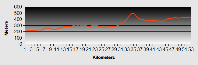
Otago - Day 2 - Clyde to Ranfurly
- Distance 92km
- Max Elevation 620m
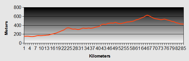
Otago - Clyde to Ranfurly Ride Profile
Ride Description
After an early breakfast we set off on a cold, cloudy, windy day along the Otago Rail Trail. Within 30 minutes we were donning our waterproofs against the drizzle.
The first 25km of the Otago trail was fairly flat, but the track was quite rough and in some places was just on the old ballast that the rails used to lie on. The 'Chatto Creek Tavern' sign tempted us in for morning coffee. We chatted to an English couple who were also cycling the route, over five days using nice B and Bs.
From there, the track started to wind up over Tiger Hill. It was still rough and the headwind was increasing in intensity. We passed lots of other cyclists that were going fast the other way, downhill with a following wind.


The Poolburn Gorge was the one of the most picturesque parts of the ride through a rocky schist valley, but the wind was funnelled through the many cuttings, increasing its intensity.
The Otago Rail Trail goes through two tunnels, about 200m long with no lights, which made it interesting, and across several bridges and a viaduct. From there it continued, in a straight line, through gently rising, featureless farmland with no shelter for mile after mile. By this time we were both getting fed up with the relentless monotony and the roar of the wind in our ears. A notable point was that we did cross Latitude 45 deg south twice.


After a long hard slog we reached the summit at 618m, but going downhill we were frozen and had to put on long tights, jumpers, gloves and waterproof tops.
Going through one farm we had to stop as the gate across the Otago trail was closed. The whole family were involved in trying to move a flock of sheep from a field on the left side of the trail to one on the right. There were four of them. Dad on a quad bike, two teenage children on trail bikes and Mum on a bicycle. There were ably assisted by three dogs. The sheep were nervous about crossing the track and were milling around in circles. There was a lot of shouting and arm waving and the Mum gave the most impressive display, tearing around the field on her bike, out pacing the powered vehicles and the sheep. Eventually the combined forces of humans, vehicles and dogs persuaded the sheep across the line and the gates were opened again to let us through.
After leaving at 9-00am we arrived at Ranfurly around 6-30pm and checked into the campsite where we had booked a cabin. We were grateful that it had an electric fire as it was very cold. After showering we walked into town to the local hotel for a nice meal.
Otago - Day 3 - Ranfurly to Middlemarch And Train To Dunedin
- Distance 60.2km
- Max Elevation 430m
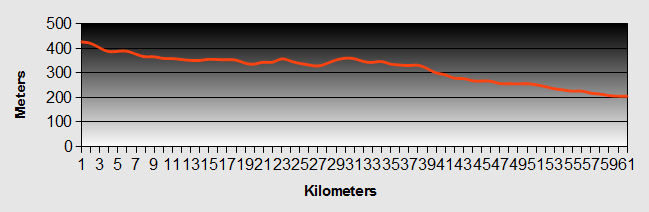
Otago - Ranfurly to Middlemarch Ride Profile
Ride Description
We had to get up seriously early today as we had to get to Middlemarch to catch the 1.00pm train to Dunedin, so we were away by 7-30am.
The route was all flat or gentle down hill with, hallelujah, a back wind. We saw a lot of other cyclists along the route and we overtook all of them as we maintained nearly 20km per hour.
It was very scenic through the upper Taieri Gorge, probably our favourite part. There were several families just setting off along the trail with children of all ages. As it was very sheltered, downhill and they had only just started, they were all in high spirits. In contrast as we got closer to Middlemarch we passed another family coming in the opposite direction, up hill into the head wind. Dad and the kids seemed OK, but mum was in tears and looked ready to give up.
We completed the 60km to Middlemarch by 11-15am, so had an early lunch in the "Quench" cafe and then had a good look around the station while waiting for the train.
The train was 30 minutes late as it was waiting in Dunedin for a cruise ship party to arrive. As its arrival time approached the activity on the platform increased. The "Lions" had a stall serving hot dogs and the passengers were milling around taking photographs and looking at the old rolling stock. Finally we saw the lights of the train coming up the track and the Taieri Gorge train pulled into the station. The 260 passengers were disgorged onto the platform, which was now extremely chaotic. The train guard directed those getting onto the train to collect their tickets from a table that had just been set up on the platform. Luggage (and bikes) had to be taken to the guards van at the rear and lifted from ground level, 4 feet up into the carriage. We collected our tickets and then it was "All aboard!"


With a lot of waving and shouting, the train pulled out of the station for its two and a half hour journey to Dunedin, Otago. We sat with some other cyclists and chatted about our trip as the train wound its way through the beautiful Taieri Gorge. Passing between carriages necessitated going outside into the open and crossing the precariously moving coupling. Each carriage had an outside platform where you could stand and take pictures and there were plenty of opportunities to get some good shots.
Half way along we stopped at Arthur's Knob, so named after one of the previous Chairmen of the railway who loved this particular spot. We all spilled out onto the track for yet another photo opportunity in this stunning part of Otago county.


As we rode the guard regaled us with stories about the history of the line and kept everyone entertained.
Before we knew it were were arriving in Dunedin and as we walked down the platform with our loaded bikes we were surprised to meet up with Ian, who had come to pick us up in his car and trailer. He had texted us, but we hadn't even bothered to switch the phone on, being so intent on getting to Middlemarch. It was a relief, Dunedin really is a hilly city and their house, Upside Downs, was about 9km from the station.

Otago - Day 4- Dunedin
We stayed with Ian and Chris. Karen and Ian were at school together until they were eleven and she was the first girl that he ever kissed, (but then so it was for every other boy on Whyburn Lane - harlet). They looked after us and fed us really well and took us to see all the sights.

We particularly enjoyed the Otago Peninsular ...
...and the penguins although we only saw a couple of them from a distance.


We went to the Albatross colony also on the Otago peninsular and saw several of these huge, majestic birds soaring overhead.
A visit to Baldwin street was a must, and at 44 degrees of incline it is reputedly the steepest street in the World.


The view from the memorial overlooking Dunedin and the south of Otago was stunning.
On Sunday afternoon we were treated to a barbecue at a friends house to celebrate Ian's golf team winning the Legends 2010 tournament at the local golf club.
It was nice to relax, be well fed, sleep in a comfy bed and be chauffeured around for four days, but all good things come to an end and after a morning of essential bike maintenance we were once again ready for the road.
Otago - Day 5 - Dunedin to Oamaru (by Bus)
|
Ian drove us into Dunedin with our bikes and gear in the trailer to catch the 12-40 bus up the coast to Oamaru. It was preferable to cycling up the very busy and hilly Highway 1. Oamaru promotes itself as the "only Victorian Town in New Zealand"and used to be a significant industrial centre and transport hub with its harbour, railway depot and station. Many of the original buildings and warehouses are built in the local "whitestone", and have been renovated and converted into tourist shops and restaurants. |
 |
 |
Steve had to try out the penny farthing at this specialist shop and museum. We stopped short of trading in our bikes though. |
|
After dinner we walked round the harbour at dusk to see the little blue penguins. In our usual Yorkshire style we refused to pay the $25 each to go into the official viewing centre. |
 |
Instead we spent $12 on two beers and, as suggested by Lonely Planet, waited till it was dark and most of the tourists had gone home. As we walked back along the harbour side we saw four of these cute little fellows making their way across the road to their nesting sites. Unlike some of the idiots that we witnessed, we didn't take any photos as the flash frightens the penguins.
Otago - Day 6 - Oamaru to Kurow
- Distance 68.9km
- Max Elevation 280m
Otago - Oamaru to Kurow Ride Profile
Ride Description
The camp site was well positioned, south of the town, to take the back road from Oamaru and through Weston on a quiet back road instead of along Highway 1. After an initial brief climb the road meandered through rolling countryside with large farm estates of meadows and mature spreading trees. They had grand names like Windsor Park.
At Ngapara we passed a historical flour mill that is still working today.
We then commenced a longer climb up to a plateau of limestone rocks and grazed grassland, before dropping down into a gorge in expectation of seeing the Elephant Rocks. We didn't see any signs and eventually thought we had found them. The cliff face was worn away, but patches of darker stone were left. We thought that these darker patches looked like herds of elephant (use your imagination). We had found the Elephant Rocks, or so we thought.


Climbing out of the valley onto another plateau we saw the sign to the real Elephant Rocks. They do look remarkably like a herd of big lumbering elephants grazing in the valley.
Turning onto Highway 83 we stopped in Duntroon for lunch and had a look at the old Blacksmiths...


... and the Gaol.

This is a lovely quiet, scenic road, little used by the camper van or bus traffic. It was a windless day and the ride along the Waitaki valley was just a gentle ascent so we soon arrived in Kurow.
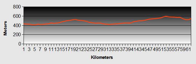
Otago - Day 7 - Kurow to Omarama
- Distance `52.5km
- Max Elevation 500m
Otago - Kurow to Omarama Ride Profile
Ride Description
Today was a dam day (that's dam not damn). The Oamaru valley and the surrounding hills have been developed to form an extensive network of reservoirs and interconnecting canals primarily for the generation of electricity.
Quote of the day seen painted on the back of a camper van which kept Karen giggling for most of the ride "My wife is a sex object... I ask for sex, she objects."
First on the way up the valley was the Waitaki dam at the foot of the Waitaki Lake. This was the last dam to be built using just picks and spades. It is also rare as it has no sluice gates, any excess water just spills across the top of the dam. The rest were all constructed with mechanical assistance. The road follows the side of the reservoirs and the canals that connect them together. The water is laden with 'rock flour' that make it milky, reflecting the blue or grey of the sky and the greens and browns of the hillsides. Thus the colour of the water changes continuously.
Further up we came to the Aviemore Dam at the head of its namesake reservoir. At the far end we rode into Otematata for a coffee stop. From there it was a long steady climb over a saddle before dropping down to the side of Lake Benmore. Sitting on the side of a small inlet that formed a sheltered bay for boats we enjoyed the sunshine while eating our lunch.
It was then only another 10km or so to our stop for the night at the Top 10 site in Omarama. We had a warm welcome and notching up a first in New Zealand, were given thick, white complimentary towels for the showers.
Otago - Day 8 - Omarama to Lake Ohau
- Distance 61.7km
- Max Elevation 600m
Otago - Omarama to Lake Ohau Ride Profile
Ride Description
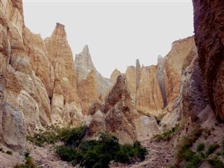
Leaving Omarama we followed the main SH6 north towards Twizel. It was a clear sunny and calm day. A few kilometres out of town we turned off to take the 20km round trip detour to see the Clay Cliffs. Half of the road was on gravel and we were dubious as to whether the ride would be worth the effort, but as the rest of the days ride was only 35km, we pressed on. It was only when we got to a gate within 4km of the Cliffs that a sign requested payment - $5 for a vehicle and $20 for a bus. There was no mention of bikes so we didn't pay anything.
Our first view of the Cliffs rewarded our efforts. A little further on, where the track got really steep and rough we left the bikes and walked up the hill to get a closer view.


After a few hundred metres we turned back to take in the view across the valley.
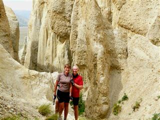
As we trudged back down the hill a four wheel drive came down and stopped. They remarked about how spectacular the Cliffs were further up and they would take us up in the four wheel drive. Never ones to refuse an offer we went back up the hill in comfort, parked and walked through a narrow cleft into a circular chasm with towering clay pillars all around. Their teenage daughter even accompanied us to take our photo.
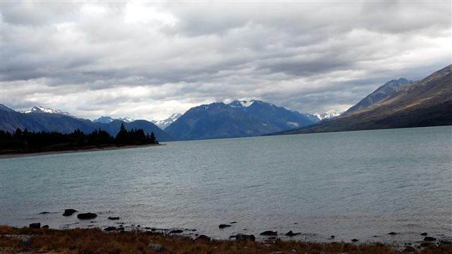
Retracing our tracks back to the main road we continued on SH6 before turning west, off the highway for another one way detour to Lake Ohau. We rode to the top of a rise looking across the moor-like terrain to the distant hills and sat to eat lunch. By now the wind had got up and as we set off down the slight hill towards the lake it was blowing straight in our faces. Despite the downhill, we had to pedal hard all the way for the next 15km to reach the lake, which had been whipped into a firmament by the strong winds. Waves broke on the shore and the wind howled through the pine trees. We consoled ourselves that at least tomorrow there would be a tail wind to take us back uphill.
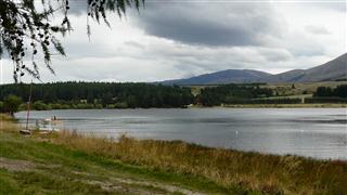
A little further along the lake shore we reached the camp ground on Lake Middleton, a much smaller lake next to Lake Ohau and well sheltered from the north westerly winds. It was a basic site with toilets and water only, but it was peaceful and our pitch had lovely views to the mountains.
New! Comments
Have your say about what you just read! Leave me a comment in the box below.