Cycling the Carretera Austral
Cycling The Carretera Austral is one of South America's most iconic routes and is a must for many cycling tourists. Soaring, snow-capped peaks, azure blue rivers and lakes, primeval rainforest, and remote roads least travelled are just some of the reasons that make this route such an enticing experience. The Carretera Austral is the colloquial name for Chile's highway 7 and it runs due south from the most southern Chilean city of Puerto Montt to the outback town of O'Higgins on the north end of Lago O'Higgins. The total distance is just short of 1300km. Due to a massive landslide at Villa Santa Lucia in late 2017 the road was completely impassable for months.
The ways to by pass the landslide were:
- continue down the 7 to Puerto Cárdenas and take the passenger ferry along Largo Yelcho to Puerto Ramírez, but no guarantee could be given as to whether the ferry took bicycles or not.
- take highway 5 to the island of Chiloe, travelling south to Quellón and then take a ferry to El Chaitén (the closest place on the mainland) Port Raúl Marín Balmaceda, Puerto Cisnes or the more southerly ports. We opted for the overnight ferry to Port Raúl Marín Balmaceda due to the timings and the remoteness of the port.
After our ferry journey from Quellón we rode the 74km to pick up highway 7 at La Junta and continued south from there. The total distance cycling the Carretera Austral was 1056km.
Schedule
- Day 1 - Raul Marin Balmaceda to La Junta
- Day 2 - La Junta to Queulat National Park
- Day 3 - Queulat NP to Koon Kan Camp
- Day 4 - Koon Kan Campsite to Villa Maniguales
- Day 5 - Villa Maniguales to Coyhaique
- Day 6 - Coyhaique to Cerro Castillo
- Day 7 - Cerro Castillo to Wild Camp
- Day 8 - Wild Camp to Rio Tranquillo
- Day 9 - Marble Caves
- Day 10 - Rio Tranquillo to Puerto Bertrand
- Day 11 - Purto Bertrand to Cochrane
- Day 12 - Cochrane to Camping Caiquenes
- Day 13 - Camping Caiquenes to Rio Bravo shelter
- Day 14 - Rio Bravo Shelter to Cyclist's Shelter
- Day 15 - Cyclist's Shelter to O'Higgins
Our ride descriptions give an account of the ride that we completed. As part of the description we also provide links to Wikiloc or Google maps and elevation profiles based on mapping data available through the internet. The ride profiles are smoothed to give what in our opinion is a more beneficial view of the profile. We use paper maps, GPS and on line data to plan and conduct our rides. We are happy for you to use our descriptions, but be aware that we do not guarantee the accuracy of the information provided as situations surrounding any ride change over time.
Cycling The Carretera Austral - Day 1 - Raul Marin Balmaceda to La Junta
Cycling The Carretera Austral - Day 1
Leaving the ferry on a gorgeous still morning, we cycled 74km all on track, which made for hard riding, but the scenery and solitude were all worth it.
Ride Description
To commence cycling the Carretera Austral we needed to take the ferry from Quellon, which took 8 hours so we got as much sleep as we could in the reclining seats. A beautiful dawn greeted us as we wheeled our bikes off the boat at Raul Marim Balmaceda jetty. The golden sun was just rising through the early morning mist and there wasn't a breath of wind. We cooked our breakfast porridge on the deserted beach of a small sea inlet.
 Getting off the ferry
The road to La Junta is unsurfaced and
follows the Rio Palena valley. After 5km there was a small car ferry
over to the opposite bank of the river. As all the other ferry traffic had departed, we were the only passengers
 Beautiful sunrise
 Cooking breakfast
 Waiting for the ferry
Initially we rode through lush forest on the river bank and then started a slow climb up the hillside. There were a lot of roadworks now, with the road being widened and new river bridges built. This meant the surface was very rough, loose and tiring.
 Road to La Junta
 Waterfall on X12
It also started to rain so out came the waterproofs. Once the rain cleared we stripped off again and put our wet gear over the rear bags to dry. After a while Steve realised that one of his gloves had fallen off his rack and went back to try and find it.
After a couple of kilometers and with no sight of a glove he decided to flag down a car coming towards us and asked them to look out for it. If they found it they could pass it to another motorist, travelling in our direction, and get it back to us!
We completed the final 20km to La Junta but no glove was returned to us. In need of a good nights sleep after two disturbed nights we booked a cabana, went out to eat, and had an early night.
Cycling The Carretera Austral - Day 2 - La Junta to Queulat National Park
Cycling The Carretera Austral - Day 2
All on tarmac. An easy 66km with a short ferry ride to bypass landslide roadworks.
Ride Description
It was an exciting day today because at last we would be cycling the Carretera Austral, the road that had first attracted us to Chile. As we packed the bags Steve went to throw his partner-less glove in the bin. Karen persuaded him to hang onto it for a little longer.
 Reunion with the glove
About 20km further the smooth road ends and the next section along the side of Lago Risopatron is grit and hilly. Beyond the lake we came back onto tarmac and stopped in Puyuhuapi for lunch. In the afternoon there were roadworks blocking the road along the side of a sea fjord so we had to get on a small car ferry for the next 3km
We stopped for the night at a camp-site which is at the beginning of the path to the Queulat Hanging Glacier. The plan was to get up early the next morning and walk up to see the glacier before continuing.
 Cycling The Carretera Austral La Junta
With a warm, dry morning, slick tarmac under our wheels and a flat road we made fast progress at first. After a while we saw a couple of touring cyclists in a lay-by and stopped to chat with them. They were from Bulgaria and had cycled the whole America's coast from Alaska. They were just making dough for bread that they would bake later. At the roadside was Steve's lost glove. The car driver had found it, passed it onto another driver who had passed it on to them the evening before.
 Wooden bridge
Cycling The Carretera Austral - Day 3 - Queulat NP to Koon Kan Camp
Cycling The Carretera Austral - Day 3
A tough 60km ride, initially on tarmac, but quickly onto track with a steep and rough 580m accent. Torrential rain on the climb and biting wind at the top to freeze us. The downhill was also on track but finally we were on tarmac and a nice ride to the campsite.
Ride Description
The really rough part of cycling the Carretera Austral started from today. It had rained all night and showed no signs of stopping as we got up. The cloud base was very low so we decided to give the glacier a miss. At least the tent wasn't too wet as it was pitched under a corrugated metal roof. Cycling away from the campsite we passed many damp backpackers waiting for lifts. A relatively easy first 20km on tar gave us time to warm up.
 Rain swelled river
 Mountain waterfalls
 Long white clouds
Then it was on to grit and roadworks, preparing for surfacing of this section of road. Twenty more kilometers and the climb began. No roadworks now but a narrow, well compacted grit surface with steep hairpins. The rain continued but the higher we climbed, the harder it fell. At one point it was so intense we just had to stop for a while because it was impossible to see! Thankfully there was little motor traffic on the road and the wind was in our favour.
 Just stopped raining
After 7 km the road reached the col at 600m. The wind was biting and we were completely soaked so we stopped for a change of clothes. Our numb hands wouldn't function properly so it took some time. Gorgeous views of volcanic cones, glaciers, snow covered mountains and swollen rivers delighted us as the road descended, even though we were still shivering with cold, but at least the rain had stopped.
 The enchanted forest
At the bottom of the hill a roadside caravan cafe served us burgers and hot coffee to thaw our frozen bits and the road surface returned to tarmac. Now we continued along the scenic Cisnes river valley with more jaw dropping views. Finding somewhere warm and dry to stay became the priority.
 Survived the storm
 Koon Kan Campsite
A 'Camping and Cabanas' sign gave us hope and we went into a cosy little cafe run by the owner, Jose and his wife. We asked if we could rent the cabana for the night, no way could we face pitching the wet tent. Our faces fell when he told us it was occupied. Instead he offered us a basic room.
It was across the yard and as we walked into it the heat from the small pot bellied stove in the corner hit us and we realised how cold we were. He rented it to us for the same cast as a tent pitch and we managed to get all of the sodden clothes and gear dry overnight. Later that evening we saw two other cycling couples who we had spoken to recently. The first two were being towed on lengths of rope by a motorcycle. The second pair were the Bulgarians who had carried Steve's glove.
 Campsite river
Cycling The Carretera Austral - Day 4 - Koon Kan Campsite to Villa Maniguales
Cycling The Carretera Austral - Day 4 Straight into a 340m climb and then undulating tarmac for 66km. A lovely ride along the valley with a great 15km downhill to finish the day.
Ride Description
 Campsite view from the road
 Campsite owners
 Descent to Los Torres
Long conversations in the morning with our camping hosts and the Bulgarians delayed our departure till late morning. The weather was dry and warm and the road was smooth, gentle and rolling.
 Cold Mountains
South of Villa Amengual is Laguna Los Torres where the surrounding mountains were perfectly mirrored in the clear, still water. We met several other cyclists touring the Carretera Austral today, all heading north, and stopped to exchange tips on the route. Traffic was very light and the valley pretty. The scenery gradually become more agricultural as it descended southwards.
 Las Torres Lake
 Rio Maniguales
After pitching the tent at a campsite we were impressed, for the first time, to see a notice asking for quiet from 11pm till 7am. Unfortunately the group of backpackers who pitched next to us obviously did not read it.
Cycling The Carretera Austral - Day 5 - Villa Maniguales to Coyhaique
Cycling The Carretera Austral - Day 5
Today incorporated a series of steady climbs totalling about 680 m, but it was an easy ride of 75km.
Ride Description
Today we decided to avoid a 650m climb on a gravel carretera and instead took a longer, but hard surfaced route down the Maniguales Valley, then north up the Simpson valley. The first 20km was downhill on a concrete road
 Rio Simpson
 Simpson valley meadow
 Dead Bus
Then we turned off onto the X240, a tarmac road, quite busy with traffic heading from the car ferry port at Puerto Chacabucco to the area capital, Coyhaique. This was a beautiful, flat bottomed valley with a broad, winding deep blue river and conifer clad slopes. It took a long time to cycle because, although fairly flat, we stopped so often to take photos
 Roadside shrine
The last 5 km were up a steep concrete cobble road which was in poor condition due to land movement. Breasting the top of the hill and rejoining route 7 again, we were somewhat disappointed by the arid, featureless views towards Coyhaique. We booked an 'apartment' for 2 nights online which turned out to be a shabby, hastily built, cheap concrete flat on a heart-sink little estate.
 Coyhaique view
 Viem as we climbed
Having checked Trip Advisor for the must-see tourist attractions we decided to give the 'pentagonal town square' and the 'stone by the river that at a certain angle may look like an Indian head' a miss. There was little of interest for us here, just an ugly sprawling urban mass on a bare hillside. So we rested, washed our gear, shopped and ate to revitalise ourselves and couldn't wait to leave.
Cycling The Carretera Austral - Day 6 - Coyhaique to Cerro Castillo
Cycling The Carretera Austral - Day 6
Another long day, some 95km with a long steady 800 m climb through beautiful countryside before a hair raising decent to Villa Cerro Castillo.
Ride Description
After a good rest and a thorough re-fuelling, we decided to try to reach Cerro Castillo in one day. Beyond there the road is currently grit all the way to O'Higgins
 Blue rock
At Laguna Chiguay the road began descending and we were lulled into believing the climbing was over for the day. Then the road changed direction and began another, slower climb into a strong headwind.
 Long slow climb
The town reminded us of one of those in a wild west film, with all wooden buildings, locals on horseback and dirt roads. Before paying for the camping we sought reassurance from the owner that there were hot showers. When we returned to him later, to inform him that they most definitely weren't hot, he let us have a shower in his own bathroom.
 Roadside llamas
Initially there was 40km of rolling hills, gradually climbing but easy. After the turn off for the Huermules Pass the climbing was steeper but aided by a following wind. Barren, dry hillsides were left behind and replaced with meadows and forest.
 Road to Cerro Castillo
The valley was really beautiful, pine forest and rocky peaks which we were able to fully appreciate as we crawled along at about 5km an hour.The watershed was at 1100m from where there was a glorious, hairpin descent all the way to Cerro Castillo and a very nice campsite overlooking the peak from which the town gets its name
 Cerro Castillo peaks
 View down the hairpins
Cycling The Carretera Austral - Day 7 - Villa Cerro Castillo to Wild Camp
Cycling The Carretera Austral - Day 7
56km of rough, washboarded track made for tough going. Progress was slow and necessitated wild camping after just 56km.
Ride Description
Where the tarmac ended the roadworks began, preparing for surfacing of the next section of road. This involved widening and straightening so the surface was rough and very loose. A lot of traffic passed us, mainly 4WD and buses. A light morning wind kept getting stronger into our faces covering us with road dust. After 8km we were hel up for for 20 minutes because of blasting work to widen a narrow gorge.
 Onto the grit
Climbing the steepish hill out of the valley was a joy compared to the toil of the morning. At the top of the hill the road levels out, following the Estero Sur valley, a lonely place with little habitation and no campsites.
 Ibanez Valley
Once through there the road enters the Ibanez river valley and the roadworks ended. This section of road is narrow, but the surface is well compacted fine earth and sand, smooth and easy to cycle.
 Ibanez river
 home from home?
After 15km we spotted a suitable
camping place, a small wooden hut next to a river with a perfect soft
grassy area to pitch the tent. It was close to the road but there was hardly any traffic, none after dark.
Cycling The Carretera Austral - Day 8 - Wild Camp to Puerto Rio Tranquilo
Cycling The Carretera Austral - Day 8
We expected a fairly easy ride today and indeed the first section was long downhill although still washboarded in places. The section along the side of the side of Lago Generral Carrera was the worst road surface of the whole trip. Having to walk the bikes over the worst sections meant we arrived in Puerto Rio Tranquilo exhausted.
Ride Description
Overnight there was a rainstorm so the tent was sodden, but we could get dressed and cook breakfast in the hut. Initially the road was flat, following the river valley then downhill on hard packed grit before a descent through tall conifer forest to the village of Bahia Murta, where there was about 500m of tarmac.
 Rio Murta lake
The road climbed and descended many times where the river meandered along the valley. Some sections had a 15cm wide 'path' on the right side where all the cyclist had attempted to find the smoothest route through, possibly the narrowest cycle lane in the World.
 Looks smooth in the photo
 Rio Murta
From here it was just 24km to Rio Tranquillo along the Rio Murta valley, 'nearly there' we thought. But now the road changed completely. Instead of the hard packed fine surface of the previous 50km the road here was made of bigger, closely packed, river smoothed stones, with no fine material on top, This meant that more than 50% of the pedalling energy was lost with bouncing over the bumps.
 Shady road
At times, even where the road was flat, it took less energy to get off and push than stay on the bike. Despite the torture of the road, the valley itself was beautiful and the deep turquoise waters of Lake General Correra cheered us up. Too fatigued to be bothered to put up the wet tent when we arrived in town, we booked into a small B and B for two nights.
 Murta Valley
 Lago General Correra
Cycling The Carretera Austral - Day 9 - Marble Caves
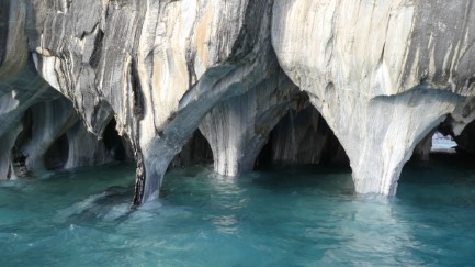
The General Correra lake is famous for its Marble Caves, a marble cliff on the lake shore which has been sculpted by the water into beautiful formations. We brought tickets for a two hour boat trip to see them on the evening we arrived. The advice was to visit early in the morning, when the rising sun reflects off the rock and the water is calm. So we got tickets for the 8am boat.
 Marble cliff
We were going with eight other young backpackers. The boat took about 30 minutes to reach the caves which were truly stunning and for about an hour we cruised around, taking hundreds of photographs.
 Morning rainbow
It was obvious as soon as we woke up that it wasn't going to be quite like that, with a strong wing and gathering storm clouds. At the boat office a large group of people were gathered for the two boats leaving at 8am.
 Marble Caves
The return trip to Rio Tranquillo was anything but tranquil. Motoring into the strong headwind we bounced hard on every wave, the front of the boat crashing down into the troughs and showering us all with water. We all laughed so much we probable wet our pants, but as they were so wet already it didn't matter !Back in the town there was nothing much to do except shop and do the washing. Even the newly opened bar had run out of beer.
 Marble Island
 Marble stripes
Cycling The Carretera Austral - Day 10 - Rio Tranquillo to Puerto Bertrand
Cycling The Carretera Austral - Day 10
The first 8km were a little difficult with a climb of about 260 m in total, but then the road flattened out with just a few smaller climbs. It ended with a 200m climb followed by a great descent into Puerto Bertrand.
Ride Description
We managed to get packed, breakfasted and away by 9am, quite an achievement. A much better road surface speeded our progress as the road climbed up above the lake giving us fabulous views. There was also a marked decrease in traffic on this section of the road.
 Dusty road
A little further south, we crossed over the bridge between the enormous Lago General Correra and the smaller Largo Bertrand and started climbing to another watershed. Then there was a long, smooth descent into Puerto Bertrand and a small campsite on the lake edge.
 Views from the road
With a tail wind we were soon at the south end of the lake and ate lunch in a newly built shelter at the road side which protected us from the brisk wind.
 Bridge between the lakes
 Team photo
 Dusk at Puerto Bertrand
This small village is becoming a popular tourist spot, offering water sports and rafting on the Rio Baker, but although there are many businesses offering activities there are no cafes or restaurants and only one tiny shop. We spent the evening drinking and chatting with three other Chilean couples who were on the same campsite.
 Lago Bertrand
Cycling The Carretera Austral - Day 11 - Puerto Bertrand to Cochrane
Cycling The Carretera Austral - Day 11
48km, a mix of tarmac and track with some steep climbs, the biggest onlly 200m, but in total we climbed approximately 700m. Stunning scenery and views.
Ride Description
The Carretera Austral now runs along the valley of the Rio Baker. This river drains Lago General Correra and Lago Bertrand, a massive amount of clear blue water which forms the famous rapids that so many tourists come to experience. Today we didn't see any rafts or canoes, and there was very little road traffic. Steep,rough climbs and descents were separated by smoother sections of ripio.
 River Confluence
Halfway to Cochrane we left the bikes and hiked to see the confluence of the Baker and Chacabuco rivers, the muddy, moraine filled waters of the Chacabuco contrasting with the clear turquoise of the Baker. Then it was back to the hard toil of the up and down rough road through to Cochrane.
 Rio Baker Valley
 Rio Baker
During the morning we passed two other cycling couples, traveling north and swapped notes about the road. they both warned us that going south from Cochrane there was approx 40km of very rough ripio. We in turn shared out experiences of the road out of Rio Tranquillo.
 Abandon hope?
We booked into a small bed and breakfast for a couple of days. It was a bit like staying at your Grandma's house when you were young. She fussed over us, looked after us and cooked a nice evening meal for us.
Cycling The Carretera Austral - Day 12 - Cochrane to Camping Caiquenes
Cycling The Carretera Austral - Day 12
Another day all on ripio, but not as rough as we had expected. Gradually climbing up to 426m followed by a an exhilarating downhill to arrive at a campsite on the shore of Largo Vargas after a 73km ride.
Ride Description
After the day off in Cochrane to shop, wash and feed we set off with trepidation from our lovely warm B&B into a freezing cold Patagonian morning. From the town centre Route 7 is a broad dual carriageway. Once past the last house it reverts to a narrow, grit track.
 Forest road
Here there was a tiny wooden cottage at the side of the road with a 'bakery' sign on the closed gate. We went through the gate and knocked on the door which was opened by an elderly lady who sat us down at the little table and served us fresh baked bread rolls and home-made plum jam with a steaming mug of Milo to wash it down.
 Busy roads
 Lago Esmerelda
After the conversations with the other cyclists we were expecting a difficult ride but it was actually pretty good, well compacted for the first 15km before we got to some badly wash-boarded sections. Forty km of gentle climbing was followed by a rapid descent into a river valley.
 Picnic with a view
Fueled with bread and jam we literally flew along the next 20km but just as the blood sugar started to drop the climb to a watershed began and the wind was blowing hard towards us. The valley was broad leaf forest with occasional farms, the scenery reminding us of Scotland.
We headed to a small campsite that we had found on 'I-Overlander'. Once again we were the only campers. Steve cooked up an Ainsley Harriet dried couscous supper which satisfied our hunger but the lack of alcohol to wash it down was sorely felt.
 Couscous for two
Cycling The Carretera Austral - Day 13 - Camping Caiquenes - Rio Bravo shelter
Cycling The Carretera Austral - Day 13
Leaving Cochrane, the first 30 km were flat riding along the Rio Baker river valley. Then the road climbs almost 400m up a steep gorge before a great decent to the ferry at Puerto Yungay.
Ride Description
It drizzled with rain all night, with the water dripping off the trees onto the tent. We got an early start and cycled along through more beautiful forest with massive roadside ferns interspersed with a few fields but very little human habitation.
 Rio Vargas
Mid-afternoon the wind increased so we stopped for a snack and draped the tent over a gate to dry. Now came a steep descent to Puerto Yungay, the departure point for the car ferry across a sea fiord.
 Lake view
 Riding through forest
After the turn off for Tortel, the road begins a steep rough climb up a narrow gorge. It was tough going, a couple of pushing sections but the only other traffic on the road was two touring motorcyclists. From the top there were views down to several small lakes in the valley below
 Forest ferns
The next ferry left in two hours, at 6pm. There was a small waiting room but no cafe or shop is this remote place. Just two other vehicles arrived for the ferry crossing, a truck with a group of backpackers in the back and a mini-bus carrying a group of Japanese tourists who we had met at Cerro Castillo.
Once loaded, the ferry took 40 minutes to get to Barcaza Rio Bravo at the other side. Here there was a small ferry waiting room with a toilet which doubles as a cyclists overnight refuge, 'the cyclist's house'. We planned to sleep here for the night so started to unpack our gear as we watched the ferry depart for the return journey.
 Puerto Yungay Ferry
Hearing a police siren we looked out of the window to see a police vehicle with its lights flashing tearing down the hill towards us. It stopped outside and an officer jumped out and came into the room. We feared he was going to have an issue with us staying there. He was soaking wet and eventually managed to make us understand that he had missed the last ferry and his mobile phone wouldn't work. He did manage to contact the ferry and it returned to pick him up so now feeling more relaxed about staying in the shelter we could cook supper and get some sleep.
Cycling The Carretera Austral - Day 14 - Rio Bravo Shelter to Cyclist's Shelter
Cycling The Carretera Austral - Day 14
The first 23km were flat but then we were into a series of steep rough climbs. Due to the relentless rain we cut our day short and saught refuge in a roadside shelter.
Ride Description
At dawn it was completely still but the cloud base was low. We set off on the reasonably smooth compact grit road. Just 1km down the road Karens back mudguard support snapped and as Steve tried to fix it the rain started. 500m back down the road was a tiny bus shelter where we fixed the mudguard and waited in vain for the rain to abate.
 Rio Ano Nuevo
There are another two cyclist's shelters along this road, because in weather like this is it almost impossible to find a dry place to pitch a tent. We stopped at the first one and found another couple of cyclist sheltering there. They had lit a fire and were drying out all their gear. We would have been happy to share the hut with them but they volunteered to continue to the next hut once their gear was dry.
 Rain ahead
It didn't, so it was on with the rain gear which we never removed for the rest of the day. For 30km the road was level, good quality, compact grit and no traffic or habitation of any kind. Then the climbing started. Short but very steep hills, some of which we pushed up. Low clouds and rain covered glasses obscured any views. There were plenty of small waterfalls though. The surrounding lakes and huge bog areas were testament to the fact that this is normal weather here!
 Misty river view
 Warm and dry at last
It was hard work finding enough dry wood to keep the fire burning and get the gear dry but after a hot meal we felt better and settled down to sleep, even though the noise of the rain hammering on the metal roof would make it difficult.
At about 10pm we heard a call from outside “Hello cyclists” and a knock on the door. Outside was a Brazilian cyclist, absolutely soaked who had had problems with his bike and had been rescued by a man in a car who had dropped him at the gate for the shelter.Steve built up the fire again to thaw him out and eventually we all got to sleep.
Cycling The Carretera Austral - Day 15 - Cyclist's Shelter to O'Higgins
Cycling The Carretera Austral - Day 15
The final day to O'Higgins was comparatively easy and a lovely ride of about 52km along undulating track. No climb was over 50 meters but some of them were steep.
Ride Description
 Weather improving
This was our last day cycling the Carretera Austral, which ends at O'Higgins. There was no change in the weather but we were in high spirits and the road was flat and not too rough. As the morning wore on the cloud base lifted and a little sun gleamed through the mist. All along the road were impressive waterfalls, thanks to all the rain.
Lunchtime found us sitting on a bench looking overlooking Lake Cisnes as the rain stopped and the sun came out. Now it was just 10km further to O'Higgins. Riding into town we met a couple of girls who had been on the ferry the previous day who greeted us like old friends.
 Waterfall
 We've arrived!
This problem was compounded at this time because the large 'Robinson Crusoe' passenger ferry which normally carries passengers across Lago O'Higgins had mechanical problems and was awaiting a spare part. This meant that the only ferry was a small 14 seater run by another company. Because of its small size and the notorious bad Patagonian winds, it wasn't able to sail some days. Consequently the seats on this boat were in great demand and we would have to wait some days before getting ours.
O'Higgins is the most southerly town in this part of Chile. At the end of the road, the only way to travel further is by passenger ferry, so only walkers or cyclist can continue and cross into Argentina.
There is no ATM or bank here and the cheaper accommodation options only accept payment in cash. So it is a difficult balancing act trying to have enough cash to get by but not ending up with too many almost worthless Chilean Pesos.
 O'Higgins
Link Back to our Tours Page from Cycling The Carreta Austral
New! Comments
Have your say about what you just read! Leave me a comment in the box below.