Bicycle the Taiwan Mountains from South to North
Next we would bicycle the taiwan mountains. Having cycled the whole of the east coast and arrived at the southernmost tip of Taiwan it was now time to head north. The east coast had been a fairly easy ride with wonderful views across the ocean and quaint fishing ports. The west coast is where the majority of the population lives and is more industrial and agricultural than the east. So we decided to spend more time in the mountains heading north and crossing over the mountains for the wonderful long descent of the Taroko Gorge, before heading back to Taipei.
Schedule
Our ride descriptions give an account of the ride that we completed. As part of the description we also provide links to Wikiloc or Google maps and elevation profiles based on mapping data available through the internet. The ride profiles are smoothed to give what in our opinion is a more beneficial view of the profile. We use paper maps, GPS and on line data to plan and conduct our rides. We are happy for you to use our descriptions, but be aware that we do not guarantee the accuracy of the information provided as situations surrounding any ride change over time.
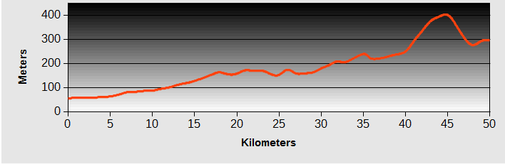
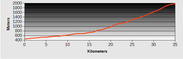
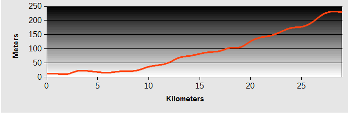
Bicycle The Taiwan Mountains - Day 1 - Henchung to Chaozhou
- Distance 76km
- Max Elevation 53m
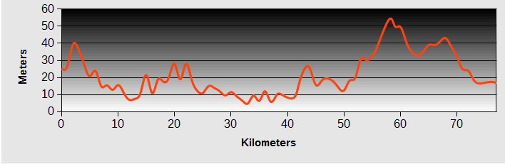
Bicycle The Taiwan Mountains - Henchung to Chaozhou Ride Profile
Ride Description
Today marked a change of direction as we turned north along the west coast on Highway 26 to start our Bicycle The Taiwan Mountains route.
It was very hot and humid and despite the fact that we seemed to have had a head wind all the way down the east coast, there was still a stiff northerly breeze making progress a bit slower. The highway from Henchung to Fangliao runs between the mountains and the sea, but then enters the broad western plain of Taiwan where the main population and industry is found.
We were now on Highway 1 with it's fast and, consequently, noisy traffic and decided to find a quieter route along the minor roads on the east side of the highway. The agricultural here is mainly fruit orchards, which stretch for miles, with flat, straight roads and the heat was intense. There were few towns and even fewer places to eat. At a scruffy roadside eatery we brought some drinks and were given a bunch of bananas to eat.
In Taiwan it seems that it used to be standard practise to have a man waving a flag to warn motorists of roadworks ahead. With increasing wages it appears that it's now too expensive. Instead they go to great trouble to dress up shop dummies, using small motors to move the arms up and down.
 Automated roadwork dummy
Further north the roads passed through intensive chicken and pig rearing buildings, with their stomach churning odours, and fresh water prawn farms. Chaozhou was the nearest and largest town and by 2pm we were ready for a fast food lunch at the 7-11. Because we entered on a minor road we found it really difficult to identify where the town centre was and seemed to search around for ages before finding it.
After a long tour around we identified three, mouldy, downtrodden hotels. Choosing the least bad of the three, Steve was sent to examine the rooms. The two old ladies in charge could not seem to understand what two strange foreigners on bicycles could possibly want in their establishment. After a lot of sign language, copious Chinese symbols scribbled on scraps of paper and a bit of translation on the phone app, we couldn't face sleeping in the horrible room so headed off towards the by-pass in hope of something better.
Close to Highway 1 was a smart looking motel and our hopes were raised. The receptionist informed us they were full and we despaired again.
Asking for directions to any alternative accommodation realisation suddenly dawned on her. "So you want a room for the WHOLE NIGHT? Well then we do have a vacancy." Obviously most people rent by the hour.
They gave us the keys to the room at the end of the row. It had its own garage and an enormous bedroom with no windows, a huge,modern four poster bed with pink curtains, low lighting and a large flat screen TV. In the bathroom was an enormous spa bath and another TV to watch in the bath. You can only imagine the choice of TV channels available.
 The Pink Room of Pleasure
The most puzzling item of furniture was the enormous leather chair thing which had a control panel attached to make various parts of it lift up and down, tilt, or move backwards and forwards at any speed of choice. We couldn't imagine what anyone would do with that.
To add a bit of fun there was a catalogue of saucy outfits and 'appliances' available from reception. We felt quite guilty that all we wanted to do was sleep. We did have a lovely spa bath though to relax the muscles.
 Chair of Pleasure
Bicycle The Taiwan Mountains - Day 2 - Chaozhou to Tainan
As the route was by train, we have omitted the profile.
Ride Description
For the last two days we had watched CNN predicting a typhoon developing south of Taiwan and yet none of the on-line weather forecasting sites seemed to be very bothered about it. But today the local news stations were broadcasting news of emergency plans to deal with the arrival of Typhoon Soulik. It didn't sound like it was going to be much fun for cycling in so we looked for somewhere to spend the weekend in safety and comfort.
Tainan, the old capital, was well south of the predicted risk area and looked like a good bet. We just had to get there. As both Chaozhou and Tainan have a railway station we hoped it would be easy to jump on a train.
At the station Steve's first tentative enquiry at the ticket office produced a 'not possible' reply. It was mid-morning and the station was quiet. We both turned on our best 'dejected' expressions to elicit some sympathy.
This encouraged the first man to study his timetable book more closely and confer with a second colleague. Then they made some phone calls and eventually sold us four tickets (two for us, two for the bikes). We had to get the first train from there to Pingdong, then change trains.
 Waiting for the Train
The station master knew all about us when we got to the ticket barrier and he escorted us onto the platform. When the train arrived he showed us the freight carriage at the back where we loaded the bikes. Arriving at Pingdong, the station master there was also waiting for us to get the bikes off and show us where to wait for our connecting train. Amazing service.
 Tainan Bridge By Night
Tainan station was easy to get out of and we booked into the Kindness Hotel,Min Sheng for three nights to give the storm time to clear. This was a good find with clean rooms responsive staff, reasonable breakfast and free ice cream and coffee all the day.
Tainan - Three days typhoon break.
 Old Gate House Tainan
 Confucius Temple
 Tainan Flower Market
 Tainan Old Fort
 Cleaning Oysters
 The Warship Museum
Soulik arrived on Saturday night and the wind and rain continued till Sunday lunchtime. We filled our time with e-mail, editing photos and watching TV, interspersed with a ride or two round the city and a bit of eating.
 Stormy Seas
Bicycle The Taiwan Mountains - Day 3 - Tainan to Zengwen Dam
- Distance 49km
- Max Elevation 142 m
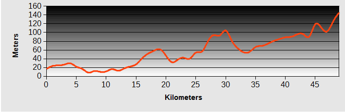
Bicycle The Taiwan Mountains - Tainan to Zengwen Dam Ride Profile
Ride Description
With the forecast for better, but still unsettled, weather for the next week we needed a new route plan. Before the weather interruption the plan was to go via Highway 20 (the south cross-island highway) back to the east coast rift valley and then climb the Taroko Gorge and head back to Taipei on Highway 7. But we had now learnt that Highway 20 is closed indefinitely following damage from a previous typhoon.
Riding out of Tainan we stopped at the railway station to see whether we could get a train back to Taitung and ride up the rift valley from there. The answer was a definite no as there are no local trains on the section of track between the west and east coast. Bikes can only be taken on this line if they are bagged and we had left the bags at the hotel in Taipei.
So with only a vague idea of where to go we set off on Highway 20 through Tainan. The first 20 km was through endless concrete suburbs but suddenly we were in green valleys again. At the rather unique police station we stopped and asked, just to make sure, that highway 20 really was impassable.
 Novel Design for a Police Station
These two very helpful police officers were waiting to greet us and assured us any attempt to ride up there was pointless.
 Helpful Police Officers
The hillsides here are covered with mango orchards and the developing mangoes are each carefully enclosed in a bag to stop them falling to the ground when they are ripe. These are the beautiful big bright pink skinned mangoes, very different from those grown in the Philippines.
 Mango Trees
By Nanxi we'd had enough riding but there was nothing we could recognise as accommodation. A Google search came up with the' Hibiscus Resort', about 8km north, so we booked a room by phone and set off. It was a large place, in the valley just below the dam. We got a suite: hallway, sitting room and huge bedroom with a balcony.
The room price also included an evening meal. There seemed to be very few guests staying so we felt slightly lonely in the immense dining room with only one other occupied table. The meal was supposed to showcase the local cuisine but it was a strange affair, ham fritters served with a very sweet yellow mango flavoured sauce and a tea flavour jelly for dessert.
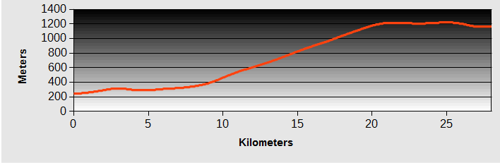
Bicycle The Taiwan Mountains - Day 4 - Zengwen Dam to Chiayi
- Distance 84km
- Max Elevation 900m
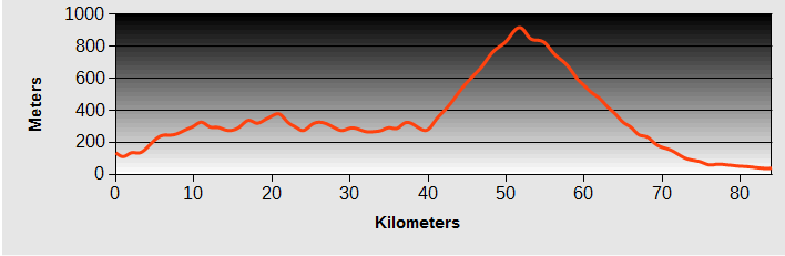
Bicycle The Taiwan Mountains - Zengwen Dam to Chiayi Ride Profile
Ride Description
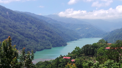
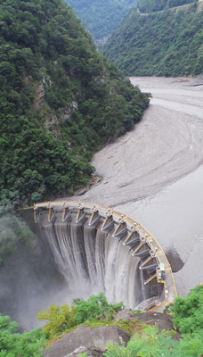
With no definite decision on today's route, we got to the resort gates and stopped for a vote, left or right? Left would take us back the way we had come and on the easier route north. Right took us up to and over the dam and then onto highway 3 along the east side of the reservoir. A much more demanding but scenic ride. Of course we picked right.
The road dropped down to cross the river and then began a steep climb up to cross over the top of the dam. From there it climbed some more, to join Highway 3. It follows the eastern edge of the reservoir, climbing and descending the numerous flooded valleys.
 Zengwen Reservoir
This area, around Alishan, was reported on CNN news as having had over 900mm of rainfall as typhoon Soulik passed over. The clean up effort was at full tilt with numerous teams of workers removing fallen trees and clearing landslide debris. Everyone assured us that the road was passable.
There were more mango trees along the way, with groups of pickers using nets on long sticks like big fishing nets. We brought a couple to taste and they were fabulous. By lunchtime we were at Dapu, a small town at the north end of the reservoir, and had lunch in the 7-11.
From here we began the long, 700m climb out of the valley. It was quite steep in places, needing 1st gear. The sun disappeared behind a blanket of cloud which helped, but the sweat was dripping off. The views back over the reservoir were wonderful and the small vans with the road workers in them kept passing us with the occupants shouting encouragement.
The col was just above 900m and from there was a continuous snaking descent on a silky smooth road nearly back to sea level. With minimal traffic it was an absolute delight.
 View From 1000meters
As the road flattened out we turned off Highway 3 to take a minor road through small villages towards Chiayi. This is an enormous conglomeration and we seemed to go many kilometres before we found the centre of the city and the hotels. Being tired, hungry and hot makes us both cranky, so we stopped at a little bar to rest, have a beer and review what the city had to offer on the map. It was now quite late and the traffic was heavy so it was still a struggle to find the hotel.
That evening we dined at a place called (in English) Liam's Broiled Food. It was only a small place with about five tables. Each table seated 6-8 people, around three sides and had its own chef. In the centre was a large stainless steel cooking area where the chef prepared the food that you ordered. We had fish fillets, king prawns, and chicken with cabbage (no meal is complete without cabbage in Taiwan) and rice.
 Our table chef
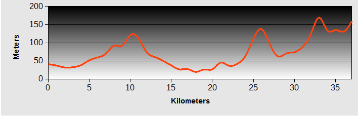
Bicycle The Taiwan Mountains - Day 5 - Chiayi to Douliu
- Distance 37km
- Max Elevation 65m
Bicycle The Taiwan Mountains - Chiayi to Douliu Ride Profile
Ride Description
The breakfast was pretty bad, the hotel was full of Chinese tourists, and we could hardly get out of the lift in the reception because of the piles of luggage and noisy guests. The coffee shop over the road was a much more peaceful place.
After the hard ride yesterday we were ready for an easier day. We headed north, trying to avoid the highways, but keeping on the plain rather than climbing into the mountains. This meant the scenery was rather tedious. Flat and alternating between market gardening and industrial areas, with loads of concrete development everywhere.
 You've heard of soap on a rope - well this is Lizard on a Rope
A couple of hours of this quiet riding through industrial estates and housing estates required concentrated navigation and it was easier to go back onto Highway 1 at Dalin and follow this through Dounan to Douliu. .
By 12.30 we arrived at our destination and had lunch at a hot-pot place, served by a waiter called Lawrence who spoke good English and insisted on taking our photograph. It was lucky we stopped early because just after booking into a hotel there was a very heavy thunderstorm.
 Praying Mantis in the Ladies Toilet
Heading out to eat that evening, we asked the hotel receptionist if she could recommend somewhere good. She arranged a taxi to take us to a place called 'Tasty'. It is one of a chain of restaurants which offer a choice of several 'set meals' which are very popular in Taiwan. You get about four courses, including a drink for a set price. It was very popular because the food was very good and reasonably priced.
Bicycle The Taiwan Mountains - Day 6 - Douliu to Shuili
- Distance 50km
- Max Elevation 400m
Bicycle The Taiwan Mountains - Douliu to Shuili Ride Profile
Ride Description
Breakfasts are rarely exciting in Taiwan. Today's was exceptionally poor. A large group of Chinese tourists also looked disappointed. With achingly empty stomachs we had to hit the road, exiting the city on Highway 3. The stormy weather of yesterday was still threatening and the clouds saved us from the heat of the sun.
 Temple in Shuili
As lunchtime approached, someone magically conjured up a little cafe with a pizza oven at the side of the road. The menu was only in Chinese but it was just a matter of opening the freezer door and pointing at the ingredients to produce a delicious, calorie laden lunch to make up for the lack of breakfast.
 Pizza - yum!
The road crosses a wide river valley on the side of a large dam. The rainfall of yesterday had made the river rise and the water roaring out of the sluice gates was wild and dark grey with silt.
At the far side of the dam is a viewing platform and cyclists rest area, built some time ago. Now the trees have grown high, there is no longer any view and the seats and shelter are falling to pieces. But we were very grateful for them as another heavy rainstorm started, forcing a thirty minute break.
 Dam Outlet
Once the rain stopped we continued under the freeway, turning off onto Highway 16 towards Shuili, riding through rice paddies. Being a more prosperous country, the rice planting is more mechanised and the tractor driver gets an umbrella.
 Planting Rice in the Rain
The clouds broke a little as we continued to Jiji, a touristy place with an old(ish) station. It was crowded with tour groups, most were waiting to catch the train.
 Jiji Station
There was a lovely old steam engine on display in the station yard but most people wanted to take a photo of the little train statue in front of the station entrance. A tourist train line ran along the side of the main road. It was an electric engine but had a loudspeaker playing imitation steam engine noises.
 Restored Steam Engine
Highway 16 continued along the river valley and was quite busy. We took the minor road, climbing a little higher through the forested slopes of the valley. It gave us good views down to the river and Shuili and there was no traffic.
 Braided River near Shuili
Dropping down from there into the town we missed the centre and rode right round the edge in a big circle before getting into the centre where the accommodation was. The options were mainly bed and breakfast places with a couple of shabby hotels.
At the side of the river there was a little cafe run by a lady who spoke quite good English. She told us we could get bed and breakfast in an apartment on the other side of the river, owned by the cafe next door, and helped us to secure it as the owner spoke no English.
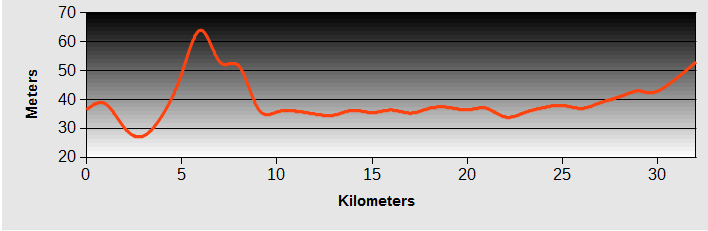
Bicycle The Taiwan Mountains - Day 7 - Shuili to Itashao
- Distance 25km
- Max Elevation 850m
Bicycle The Taiwan Mountains - Shuili to Itashao Ride Profile
Ride Description
Breakfast was served at the little cafe near the river. By 7.30am we were on the road, into the coolest morning yet, with the 350m altitude and still cloudy skies. Our destination was Sun Moon Lake, one of the most popular tourist destinations in Taiwan.
 Lovely Melons!
Originally it was a small lake but in 1934 a dam was built which increased its size. With an altitude of about 900m it offers a cool retreat from the heat of the coast and some beautiful mountain scenery.
There is a new, four lane road which climbs from just outside Shuili and in the early morning ,before the tourist buses, it is very quiet. The gradient is very gentle and we gained altitude without much effort. Halfway up the hill was a temple with this huge statue.
 Temple God
Just before the lake we turned off the main road onto the local road which runs around the whole perimeter of the lake and is very popular with cyclists, especially children staying at the local Youth Activity Centre.
 Sun Moon Lake
There are four temples and a pagoda but all of them have been built since the dam construction, to replace those lost in the valley flooding.
The tourist crush at each of them was just what we have come to expect. At Syuanguang Temple they arrive on the boat, climb the steep steps then queue patiently, in the specially roped off area, to have their photo taken by the inscribed rock, overlooking the lake.
 Form and orderly queue please
The road was actually very quiet and enjoyable with ever changing views over the lake and surrounding mountains.
Because it was weekend again we had pre-booked a bed and breakfast in Itashao and dropped off the bags there so we could continue riding around the lake.
 Syuentzeng Temple
 Smile please...
Itashao - Day off
 A Butterfly
 Another Butterfly
 Chairlift Ascent
 Pet Lizard
It was Saturday again so rather than face the busy roads we took the day off. We went for a ride on the cable car (supplied from Austria) into the hills for the stunning views of the lake and then wandered around the butterfly garden, badly damaged by the typhoon but alive with hundreds of different species of butterflies and insects. On the lake pier we met a young lad exercising his pet lizard, and for refreshment there was a Starbucks with lattes and cakes.
Bicycle The Taiwan Mountains - Day 8 - Itashao to Puli
- Distance 25km
- Max Elevation 820m
Bicycle The Taiwan Mountains - Itashao to Puli Ride Profile
Ride Description
The Sunday morning traffic was already building up as we left our accommodation. Lots of road cyclists in club shirts, groups of motorcyclist on powerful bikes and plenty of cars. This was why we just planned a short ride to get us to Puli, ready to start the big climb over the mountain tomorrow.
 Prayer Steps from the Lake
It was frustrating to drop down so much, from 900m to just under 400m, knowing that tomorrow we had to ascend 1,600m in one day. We took Highway 21 as far as Yuchi, then turned onto the NR131 which follows a pretty river valley to the south east of Puli.
 Old Tea Plantation
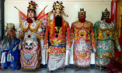
Arriving in the centre of the town there was a large crowd of brightly dressed young men with painted faces and unusual costumes waiting to join a parade.
 Puli - Facepaint
We quickly nipped through the side streets to pick up the parade as it terminated at one of the numerous small temples. It was a strictly men only affair, mostly teenagers and young adults.
 Puli Parade
They were carrying wooden structures on poles over their shoulders containing some sort of idol. Progress was slow as they performed an intricate sort of side-stepping dance and bobbed up and down as they went.
 Puli Parade
Behind them came more men in giant god-like costumes. There was accompaniment on drums and cymbals with another group blowing long silver horns.
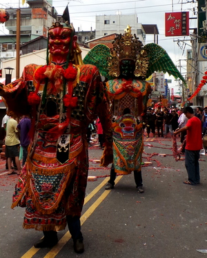
The finale, as expected; was an enormous volley of fire-crackers. In the narrow street packed with onlookers there was nowhere to hide and the whole street filled with acrid smoke and flying debris.
 Firecracker Finale
Puli is sold to tourists as a 'cultural and historical gem' but except for that wonderful parade we found little to delight us. Even finding a bar for a strengthening beer ready for tomorrow was a struggle and a good restaurant out of the question.
Bicycle The Taiwan Mountains - Day 9 - Puli to Qingjing
- Distance 35km
- Max Elevation 2000m
Bicycle The Taiwan Mountains - Puli to Qingjing Ride Profile
Ride Description
Don't for one minute think that a 36km day was a cinch. It was tough, tough, tough, hot, hot, hot and the traffic was continuous. But it was a fabulous climb on Highway 14.
We were not sure what services we would find on the route but we needn't have worried, there were frequent 7-11's all the way up to Qingjjng as well as frequent (expensive) fruit stalls. The first 20km was a pretty easy gradient, following the river valley. The traffic was constant, mainly lorries loaded with fruit, vegetables and gravel coming downhill, and empty lorries returning. Later in the morning the tourist buses and cars were pretty much nose to tail.
After that warm up section the gradient increased as the road went up the valley side. With the slightly cooler temperature the crops changed to small tea plantations and grape vines. The views were wonderful and the cloud base high.
 More Tea Plantations
From the 25km mark the going was much tougher, with short sections of at least 10% gradient and, because of all the traffic hemming us to the side of the road, a couple of the right turn hairpins had to be pushed. It was slow, first gear for the next 10kms
 Old England Hotel
But the sights were amazing and took our minds off the toil. We began to understand why all these people drive up this road.
There are lots of expensive houses and hotels. One of them, called The Old England Hotel, had a tower which closely resembled Big Ben, and a Tudor style building. There is a large area of grazed pasture, called 'Mountain Meadow', teeming with tourists, and a sheep farm.
Qingjing, at 1,600m has a vast range of tourist accommodation. We chose to stay in a small hostel, which did evening meals, right next door to the 7-11 so we could shop and eat without stressing the tired muscles.
 Sheep Farm
On the ascent we had met a cyclist called China, who owns a cycle shop in Taipei. He took our photos and advised us that we needed to get to the summit tomorrow by 12:00, as the clouds often roll in during the afternoon and there can be thunder storms.
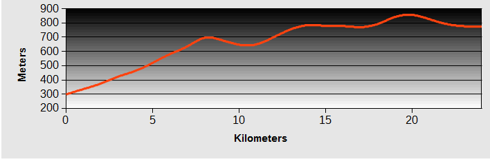
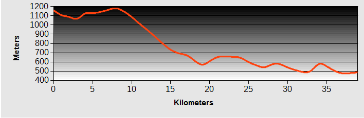
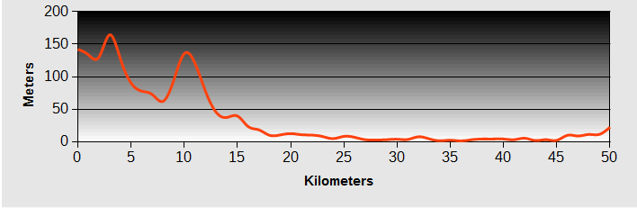
Bicycle The Taiwan Mountains - Day 10 - Qingjing to Xincheng
- Distance 104km
- Max Elevation 3250m
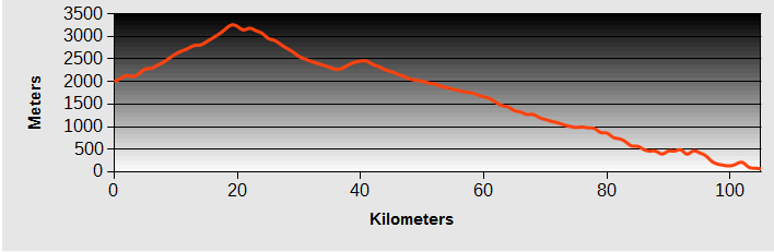
Bicycle The Taiwan Mountains - Qingjing to Xincheng Ride Profile
Ride Description
In readiness for the long day ahead we were up at 6am and off by 6.30 with a packed breakfast. We were blessed with the most perfect of mornings for a mountain climb, with clear blue skies and not a breath of wind, one of the first settled days since the typhoon.
Stopping for the night at Qingjng was a wise decision as it is at the top of the steep section of ascent so there was a relatively easy uphill to get the muscles loosened up.
 Agriculture in the Cool Valleys
The traffic was lighter than yesterday but still many lorries laden with fruit and flowers and also crowds of morning joggers heading downhill.
Above the village the road reaches a ridge between two valleys. Although now above 2,000m there are still plenty of broad leaved trees to provide shade. As the road snaked across the ridge, we got alternating views down into the valleys at each side.
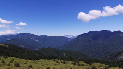
After the turn off to Lixing there was a sudden change in the road from two lane to just a narrow but well surfaced road and a noticeable decrease in traffic, no buses or heavy lorries allowed up here.
 Alpine Scenery at the Top
Climbing higher, we left the broad leaved trees behind for massive pines, which could have been over 1,000 years old given the girth of their trunks. A stall at the side of the road tempted us with juicy peaches but charged a fortune for the pleasure.
The going got tough again at about 14km and by now the thin air was affecting us badly. The legs went round OK but the oxygen soon ran out meaning cycling 200m then having to stop till the heartbeat got back to normal.
 Nearly There
A couple of men in a little van were unloading boxes of tiles onto the side of the road as its engine was also struggling to climb the hill. A couple of the steepest sections saw us pushing. But we didn't feel too bad as some much younger cyclists, with unloaded bikes, were doing the same.
There was the promise of sustenance at a viewpoint with a large marquee of food stalls. After perusing the unappetising offerings we just brought a couple of sausages. Outside the tent we met a young man sitting against his folding bike who spoke quite good English. He told us he had come up from Puli that morning.
 Guy on Folding Bike
Here, nearly at the top of Hehuan Mountain there are grazed green mountain pastures and the most stunning views of a multitude of peaks stretching in all directions. The last 2km was a torture. At 3,250m with no acclimatisation our brains told us the slope was rideable but the heart couldn't cope.
 Mount Hehuan
With great elation we crested the ridge, the highest section of public road in Taiwan, and joined the crowds of tourists to take photos in every possible direction. The time was now 1pm and the first clouds were stating to gather in the distance. we
 3275m high
The gradient of the initial descent was even steeper but there were still some cyclists slogging their way up ( carrying balloons but not any bags).
Not far down the slope the young man with the folding bike had stopped with a puncture. We offered help but he refused it. That was the end of his ride and he thumbed a lift down the mountain, passing us in a car, waving out of the window.
 The Way Up
On the banks at the sides of the road were the most beautiful alpine flowers: bright blue gentians, dark purple orchids and white mountain lilies. We had to stop and take photos of them all (actually we were having to push up another hill).
 Mountain Orchid
 Mountain Lilly
The road dropped down around massive hairpins and we could look down and see it continuing far below us. At one point it seemed to cling tenuously to the bare, unstable mountain side with just a sheer drop below.
 Unstable mountainside
We whizzed on for about 20km before starting another 200m climb at the start of the Taroko Gorge. It was very difficult to get the legs moving and we were now desperate for more food, having consumed all our carried supplies.
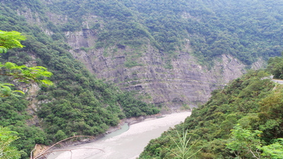
The end to end length of the gorge is 19km, but because of the hairpins there is almost 70km of downhill, through the stunning marble terrain. The enormity of it almost defies description. No photograph can really do it justice, but we had to try.
 First Sight of Taroko Gorge
Towering peaks above, plunging to a narrow valley, so far below the bottom is out of sight and the road following a narrow ledge, blasted out of the sheer walls about 50 years ago. More than 450 workers lost their lives in the process. There are plenty of tunnels and higher up, with no electricity supply, they are unlit and have bends, a bit scary.
 Taroko Gorge Road
The road surface is in amazing condition, smooth and free of debris. Because of the restricted access due to the major landslide at the bottom of the gorge, there was very little traffic, just us, the birds, the flowers, the views and the snaking smooth descent.
 Looking down to the road far below
Just as all hope of food seemed lost, there was a little restaurant close to the Bilyhu sacred tree, another ancient pine reckoned to be over 3,500 years old. The food here was good and invigorated us for the last couple of hours of downhill. Clouds started to roll up the valley and we had to put on our high vis tops to ride through the mist.
 Clouds below
 Bilyhu Sacred Tree
The ride up the gorge must be exhausting and these upward bound cyclists needed a nap.
 Taroko Gorge Tired Cyclists
There are lots of tourist attractions along the way but we were anxious to get to our accommodation before dark and more importantly, to get through the road works at 6.10pm.
We finished at 6.30pm, exactly 12 hours after setting off from Qingjing, one of the most memorable mountain days ever.
 The little black patch is the road tunnel
Bicycle The Taiwan Mountains - Day 11 - Xincheng to Datong
- Distance 29km
- Max Elevation 230m
Bicycle The Taiwan Mountains - Xincheng to Datong Ride Profile
Ride Description
For the return to Taipei we planned to follow Highway 7 from Yilan north through the central mountains. So this meant we needed to get the train from Xincheng to Yilan to avoid the heavy traffic on the coast road. Having brought the tickets we had to get the bikes from the ticket hall to the platform.
With no lifts at Xincheng station this meant rolling the bikes down the steps to the underpass and them pushing them up the other side. The steps had a bike ramp at the side but the space was too narrow for the panniers.
 Tricycle in Yilan
With only a few minutes before the train, we dashed down and a man helped us by carrying the unclipped panniers and pushing the back of Karen's bike. But we went up to the wrong platform so had to repeat the whole process a second time. At least the 90 minute train ride let us have a rest and we arrived in Yilan for lunch.
After eating and shopping we set off on Highway 7, north west out of the city. The river plain here is vast and flat between steep, tropical jungle clad mountains. With its rich alluvial deposits the river banks are used for growing vegetables and water melons.
The hillsides here are perfect for tea growing and we stopped for the night at a little village, famous for its tea but with a name that eludes us. It was full of tea houses and bed and breakfast accommodation with an ample sprinkling of tourists.
We had expected to find a shop on the way from Yilan, and buy food supplies for the next day's climbing, but there was nothing. The kind b and b owner gave Steve a lift to a 7-11 to do the shopping.
 Baby Swallows at our B & B
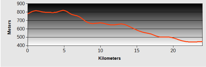
Bicycle The Taiwan Mountains - Day 12 - Datong to Ming Chih
- Distance 29km
- Max Elevation 1200m
Bicycle The Taiwan Mountains - Datong to Ming Chih Ride Profile
Ride Description
Once again the morning's breakfast offerings were very meagre, with seven people sharing a buffet which would comfortably feed two. So we departed with empty stomachs for a 1,000m climb.
 Ethnic minority sculpture
There was a 12 kilometre warm up, gently climbing the side of the wide river valley. It's flat alluvial shingle floor was being used for agriculture with long rows of vegetables growing in the stones. There is a unique bed and breakfast place here, a modern, circular building with a top floor that slowly rotates.
There were no shops or cafes before the turn off for Ming Chih, so we had more, slightly less expensive, peaches at a roadside stall. It was hot and humid with no wind.
 River bed agriculture
Immediately after the turn off we started to climb on a narrow, quiet road, through jungle forest, in a towering river valley. The first 5km was steep and difficult with some sections over 10% gradient and being only 400m above sea level the heat was intense. We stopped to rest at least four times and every single piece of Karen's clothing was drenched, with sweat dripping off the hem of her leggings onto the road.
Other than a few private cars, the main traffic on the road was mini buses, ferrying passengers to and from the resort at the summit. We gradually pushed higher, stopping frequently to drink and eat our snacks.
 Karen Reflecting on Life
After 10km the gradient became easier, mostly between 7 and 9%, around many hairpins, each with a mirror because the road was so narrow. The mountains still towered high above and we thought we must have about 5km more climbing.
Sitting down for another snack we were passed by a local road cyclist who told us that in fact we were only a hundred meters away from the summit, with the road then contouring around the mountain bowl to reach the descending valley.
Having to drink so much on the ascent meant we were critically low on water by now and searching for a supply to fill the bottles. The small National Park office at the summit let us fill them from their water dispenser, but the water was too hot to drink.
 Road round the mountain
The final 6km, around the mountain bowl gave us fabulous views across the mountains and back down to the river valley that we had climbed from. But it was too hazy to take good photographs.
By 2.15pm we had arrived at the big Ming Chih Hotel where the room were 3,800 NTD per night, the most expensive place yet. The only room available was in the block above the restaurant and the air conditioner was out of order. So they knocked 500 dollars off the price. At over 1,000m there was no need for air con anyway.
Because the hotel was so full, the only time available for the evening meal was 5.30pm. We sat outside and for the first time since leaving the UK we needed fleeces on. The food was very good.
 Another Sacred Tree
Bicycle The Taiwan Mountains - Day 13 - Ming Chih to Sanxia
- Distance 39km
- Max Elevation 1200m
Bicycle The Taiwan Mountains - Ming Chih to Sanxia Ride Profile
Ride Description
Everyone in the resort seemed to get up by 7.30am and restaurant was buzzing with families. Nothing great, but nice salad (yes for breakfast) and passable buns and coffee. Before leaving we wanted to visit the Ming Chih lake just down the road as we had passes for free entry from the hotel.
 Avenue of trees, Ming Chih Lake
Our intention was to stay for about 30 minutes and take a couple of photographs but we were so enchanted by it that we stayed much longer. It was a beautiful, serene and captivating place. A green water lake nestled in the high steep pine clad mountains.
 Ming Chih Lake
The lake was full of carp, terrapins, water fowl and swans who were all so used to being fed by visitors that as soon as you approached the water they crowded up to the shore and thrashed around in the water, waiting for food.
 Ming Chih Lake
There was a pagoda built on a small island and inside was a man playing haunting melodies on a clarinet. In the still air the music echoed around the water and was quite mesmerising.
 Serene Music by the Lake
After taking about 50 photos we had to drag ourselves away and get back to the hotel to pick up our bags, knowing we had a long day ahead of us. Most of it was downhill but there were four climbs of about 150m each to tackle on the way.
 Offering up Prayers
The road was narrow, following a small valley downstream through beautiful forest. On this side of the hill there was very little traffic, just an occasional car. The woods were teeming with life.
 Amazing Butterfly
Flowers,dragon flies, butterflies, honey bees, fish and frogs in the stream, and the constant deafening calls of the cicadas.
 Dragonfly
As we dropped down the valley widened and more tributaries joined it, with views down to the water and rocks below.
 Untouched Forest
There was absolutely no habitation here at all, just peace and us and it felt magic. Overhead a couple of buzzards rode the thermals, with their mewing cries.
 Buzzards
There was plenty of evidence of the damage reeked by the typhoon with destroyed concrete flood defences and landslips, but everything had been cleaned up and didn't cause any problems.
 Beware of falling rocks
Beyond the national park boundary there were some houses, built up on the hillsides, and trees cleared to grow tea and bamboo. We stopped for lunch at Baling. Setting off again we were soon held up at a traffic control for 40 minutes due to road re-surfacing.
 .....that's a BIG rock
As usual the queue of people were very relaxed and accepting of the inconvenience and sat and chatted to each other. Eventually the road was opened and we had to ride over the hot sticky tarmac which covered the tyres and stayed on persistently for the rest of the day.
 Waiting at the Roadworks
The road dropped down further and crossed a couple of tributaries and an impressive dam. The valley was now wide with a grey, silt laden river and high layered river cliffs. Steve got a ticking off for climbing on a wall to take this photo.
We stopped at a cafe for a quick coffee and just as we left there the rain started. There was shelter under a canopy at a small factory where we waited until it lessened.
There was more work being carried out further down the valley. This climber was repairing the netting to prevent rockfalls onto the road.
Only another 5km further it started again, much more seriously. It was obvious this was not going to be short and sharp so with 15km left and time pressing we had to use our ponchos and surf down the road, praying not to have to stop suddenly. It was oddly pleasant when the faster traffic passed, spraying us with the warm surface water.
 Climbing skills required for this
Sanxia is a sprawling city and with the heavy rain and busy roads it was difficult to find anywhere to stay. The Google map showed a motel in the new town area which had much better reviews than anywhere else. Arriving there it was obvious it was just the same as the last place, just lacking the special chair.
Bicycle The Taiwan Mountains - Day 14 - Sanxia to Wulai
- Distance 37km
- Max Elevation 170m
Bicycle The Taiwan Mountains - Sanxia to Wulai Ride Profile
Ride Description
Breakfast was novel, a burger and hot drink delivered by the MacDonald's just up the road. After that we road back to the old town of Sanxia to see the old street with its brick built shop houses.
 Sanxia Old Street
The old town was buzzing with life, market stalls, shoppers, busy temples, monks begging: we sat and drank coffee to give us time to take it all in.
 Begging Monks
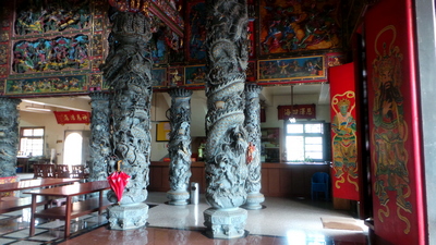
For our last night on tour we had booked into a hot spring hotel at Wulai, one of the closest hot-springs to Taipei. The plan was to cycle along NR101, which looked, on our map, to be a quiet country road, avoiding the busy Highway 3. In fact it was a very busy road running through several suburbs of Taipei with high rise buildings, some complete, some being constructed. The highlight of the morning was a wonderful temple where we were given tea to drink while we took photos of the amazing interior.
It was a rolling ride, nothing steep, but the high humidity following yesterday's storm meant that it felt very hot. The halfway point was Xindian which is the last station on the MRT. It lies on the river which the hot springs flow into and our route continued up the valley. It is a popular cycle route and, as it was Saturday, was busy with bicycles. The long rolling hills had some of the less regular cyclists, on their light MTB's pushing, wimps!
Because the river water is warmed by the springs, many families come here to swim although the rocky river bed looked like an uncomfortable place to sit for any length of time.
Our hotel room had its own stone lined tub which was filled by the soothing hot spring water which with the addition of a little bubble bath and a couple of beers was a much better place to sit.
 Follow this advice...
 ....we're trying.
Bicycle The Taiwan Mountains - Day 15 - Wulai to Taipei
- Distance 50km
- Max Elevation 160m
Bicycle The Taiwan Mountains - Wulai to Taipei Ride Profile
Ride Description
As we rode back to Taipei we passed hundreds of cyclists taking part in a sponsored cycle event. There were families with young children on their little bikes who were also finding the hills too challenging.
 Cycling Taiwanese
From Xindian we picked up the cycle route along the riverbank, following it through the western edge of Taipei city and then back to Tianmu along the Suangxi River.
We had a couple of days before our flight back to Manilla to do a bit more sightseeing and pack the bikes.
 Playing baseball in the river park
New! Comments
Have your say about what you just read! Leave me a comment in the box below.