A Bicycle Ride From Inverness to Gretna Green
Our ride from Inverness to Gretna Green formed the first leg of our ride down to Plymouth on England's south coast. In our case it was the culmination of years of planning and the start of our round the World bicycling dream.
But there are other good reasons for wanting to make the ride. Of course most people will want to do the full end to end cycle ride all the way from John o' Groats to Lands End. In the vast majority of cases, they rarely spend time to enjoy the scenery or the towns they pass through. Being intent on completing the journey in the shortest possible time, they take the well defined shortest route. Many of these folk raise thousands of pounds for well deserving causes and we take our hats off to them.
However, if you want to enjoy the journey, take in the scenery, visit new towns and meet new people you can take an altogether more relaxing approach. You don't need to go by the fastest route. There are too many lovely places to see and experience to rush the journey.
Riding our route from Inverness to Plymouth you will pass through some of the most beautiful parts of Scotland, England and Wales and visit some spectacular cities and towns.
Getting There
The easiest and most enjoyable way to get to Inverness with your bike is by train. Which you can do from most areas of the country. We took our bikes just on the local train from Aberdeen up to Inverness. Scotrail do a really good sleeper service that leaves London Euston at 21.15 and gets in the following morning at 8-31. If you chose your dates and book in advance you can get tickets for as little as £19 single. If two of you travel together you get a private 2 berth sleeping cabin in that price, plus a cup of tea in the morning. This sounds like a very civilised way to travel to us.
The return journey from Plymouth to London Paddington takes just 3 hours and we have seen fares as low as £26.
The rail companies in the UK have now really got their act together with regard to taking accompanied bikes on trains. There is no charge, but you do have to reserve them in advance so it is best to book early. Some companies do have some restrictions particularly at peak times so check the individual companies web sites to be sure.
Other options are flying if you want to risk your bike or driving. Neither options meet our environmentally friendly credentials so we don't consider them unless we really have to.
Schedule
Our ride descriptions give an account of the ride that we completed. As part of the description we also provide links to Wikiloc or Google maps and elevation profiles based on mapping data available through the internet. The ride profiles are smoothed to give what in our opinion is a more beneficial view of the profile. We use paper maps, GPS and on line data to plan and conduct our rides. We are happy for you to use our descriptions, but be aware that we do not guarantee the accuracy of the information provided as situations surrounding any ride change over time.
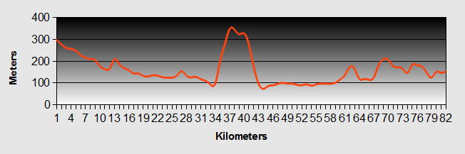
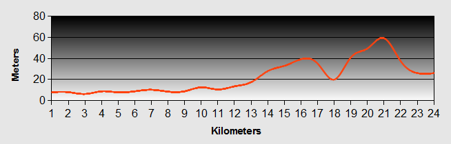
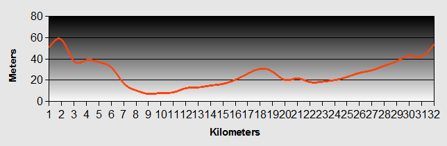
Inverness to Gretna Green - Day 1 - Inverness to Daviot East
- Distance 23km
- Max Elevation 250m
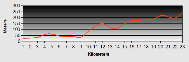
Inverness to Gretna Green - Inverness to Daviot East Ride Profile
Ride Description
We arrived by train from Aberdeen, at about 6pm ready to start our Inverness to Gretna ride. We made our way to the supermarket, purchased our provisions for the night and set off on Sustrans route 1 / 7 to our first camp site at Auchnahillin Camp Site, Daviot East. It was only a short distance up and down a couple of fairly steep hills. We were thankful for the energy bars that we had packed before we set
We had to stop at Cullodon Moore to put on our water proofs.
Along the road from Carra to Daviot a car pulled alongside Karen. "We are completely lost can you tell us how to get to so and so?" Truth be known, we did not know where were either. We passed them later still trying to find their way.
We arrived at the site and pitched the tent in the pouring rain. After a hearty meal we felt much better and settled down in our cosy sleeping bags, falling asleep listening to the rain.
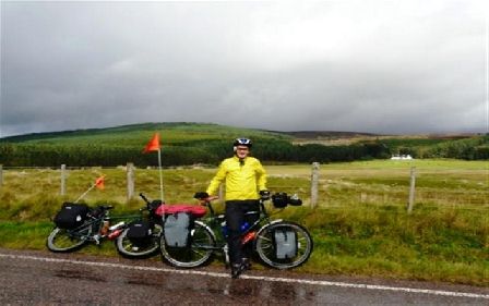
Whilst we did not get the lovely evening we had wished for our first night under canvas had passed without event. Our Inverness to Gretna journey and round the World trip had begun!
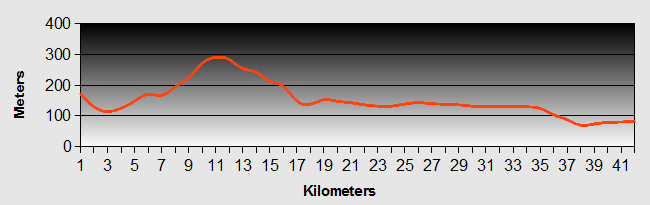
Inverness to Gretna Green - Day 2 - Daviot East to Aviemore
- Distance 48km
- Max Elevation 410m
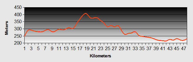
Gretna Green to Liverpool - Daviot East to Aviemore Ride Profile
Ride Description
Awoke to rain so stayed in bed late. Decided to wait for the tent to dry before leaving and see to some of our admin work. Several heavy showers during the morning meant the tent never dried so after lunch we decided to pack up anyway. Set off on our Inverness to Gretna ride at 14-00 and the route was generally uphill on quite roads and bike tracks following the A9 to eventually reach Slochd Summit at 405m high.
From there it was down hill most of the way to Carr-bridge where we stopped to take photos of the ancient, stone arched bridge.
The Inverness to Gretna route from there was flatter, but busier with traffic. We reached Aviemore at about 18-00.
 Carr Bridge
There was a motor bike rally with crowds of born again bikers on Harleys, some of whom were incapable of getting of their bikes unaided! Lots of great rock music and beer in the town, but we decided to look for somewhere to stay out of town that was a little quieter.
Whilst we eat fish and chips in a cafe we laughed as we watched two Harley's draw up. The riders and their female passengers were at least in their early sixties. The guys got off as did one of the women. But the other one had to be lifted off by the two guys.
We headed off on our Inverness to Gretna route up the road towards Kincraig, past the beautiful Loch Alvie and stayed the night at Dalraddy Holiday Park. More expensive, but clean and free hot showers!
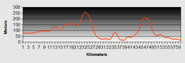
Inverness to Gretna Green - Day 3 - Aviemore to Glen Garry
- Distance 63km
- Max Elevation 470m
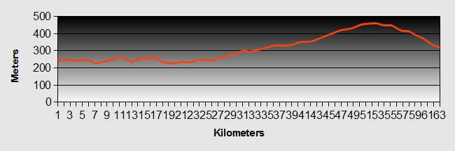
Gretna Green to Liverpool - Aviemore to Glen Garry Ride Profile
Ride Description
The Inverness to Gretna route took us down the main road to Kincraig then turned left to pick up the C7 again. The first part was very scenic through forest and the RSPB nature reserve. Approaching Kingussie we passed the ruin of Ruthven Barracks. The Barracks was built in 1719 to discourage further rebellion following the Jacobite Rising in 1715. It was used by General Wade as a center for troop movements and was finally destroyed by dispersing troops following the Battle of Culloden around 1745.
Arriving at Kingussie we again encountered the motorbikes that had ridden in convoy from Aviemore and were being greeted by a pipe and drum band. Escaping from the bikes we took cover in the nearest cafe and feasted on bacon and egg butties, cake and coffee. We bought our provisions for the next two days of our Inverness to Gretna ride as we knew that we would be wild camping that night.
 Ruthven Barracks
The next part of the Inverness to Gretna ride was hard going. A continuous slow ascent mostly following the old A9, now replaced with a dual carriageway. No shelter and a strong head wind all the way to the top. The final part was on a small gravel path at the side of the A9. Cold grey and raining. Eventually we made it to Drumochter summit at 462m, the highest trunk road pass in Britain. Met a group of four lads and a girl driving north to John O' Groats to start the End to End cycle ride in aid of the Anthony Nolan Trust.
Thankfully, from there our Inverness to Gretna ride was downhill all the way along the old road, between the dual carriageway and the railway track. We were tired and it was getting late, so we found a small clearing by the side of the road and set up our tent. We were inundated with midges so we quickly had supper and retreated to our beds.
We spent a noisy and disturbed night due to the continuous traffic all night on the A9.
Inverness to Gretna Green - Day 4 - Glen Garry to Killin
- Distance 82km
- Max Elevation 360m
Gretna Green to Liverpool - Glen Garry to Killin Ride Profile
Ride Description
We couldn't sleep so got an early start and were on the Inverness to Gretna route by 9-00am. The first 18km was downhill on the old A9 all the way to Blair Atholl, where we stopped for coffee at the Old Mill and where they still baked lovely bread in the traditional way. Delicious.
Good progress on quite flat roads, but were deflected from our track at the sight of some random guy drinking a pint of Guinness at a road side cafe in Kenmore. We just had to stop. We soon regretted this temptation when the last part of our ride developed into a grueling roller coaster ride along the side of Loch Tay, for 16 miles, mostly in pouring rain. We had to top up with our energy drinks several times along the way.
We finally arrived in Killin and fell into a local hostelry soaked to the skin. We dried out in front of their roaring log fire, while we sipped hot coffee laced with whisky.
We then had to ride a further three miles to find our camp site, High Creagan, which was decidedly seedy and at the top of a steep hill. There was nowhere flat to pitch the tent. We had to pay 10 pounds and everything was extra, even hot water.
Too exhausted and wet to complain we put up the tent in the pouring rain again, ate and fell into bed. Another bad night due to the roaring waterfall, coffee and aching limbs.
Inverness to Gretna Green - Day 5 - Killin to Callander
- Distance 42km
- Max Elevation 295m
Gretna Green to Liverpool - Killin to Callander Ride Profile
Ride Description
Today would prove to be the best bit of the Inverness to Gretna C7 ride that we would cover. If you fancy trying just a small section of this ride then this is the one to do.
The Inverness to Gretna route starts with a steep uphill section out of Killin, first along an old railway track and then onto forest tracks, the steeper parts of which have been tarmacked. After about 2 miles the track crosses the road at the summit, 288m and from there it is downhill through Glen Ogle and on nearly all the way to Callander, on the old railway track and along woodland paths with no roads at all and fantastic views across Loch Earn and the village of Lochearnhead.
Our Inverness to Gretna ride today started late. We took ages to get packed and didn't set off until almost 11-00am. We made our way back into Killin, bought delicious meat pies for lunch, and saw the impressive Falls of Dochart. The ride up the hill out of Killin was quite hard but the steeper sections had smooth tarmac.
 Dochart Falls
Our Inverness to Gretna route reached the top of the pass at 288m. The ride down the other side was beautiful, along the old railway track on the opposite side of the valley to the road with overhanging trees and beautiful views.
We stopped to eat our pies overlooking Loch Earn and were suddenly joined by a rather strange gentleman who needed to borrow a spanner to mend his bike. Steve willingly produced his best spanner and mended the bike for him.
After lunch we enjoyed a lovely ride along back road, forest track and path into Callander. As we followed the Inverness to Gretna route through Callander village park Steve started to ride through what appeared to be a slight flood, he was beyond the point of no return, with Karen in quick pursuit, as the water went up to his axles. Continuing through stoically we both emerged through with soaking feet, but the panniers remained dry.
 Loch Earn
We shopped and headed off to find our camp site at Keltie Bridge. Classed as a four start site we were counting on washing our stuff and drying everything off. The drier didn't work! We arrived in the pouring rain again and to say we were miserable was an understatement. We sheltered in the toilet block and after the rain had abated we pitched the tent. Everything was damp at best. We seemed to have been wet for the last 4 days.
Steve had done the shopping, but omitted to buy anything to actually put in the curry sauce mix he had brought. So we cycled back into the town where we had earlier seen a two eat for 10 pounds sign. We had beef and Yorkshire pudding carvery, apple pie and cream, beer and felt much better.
Inverness to Gretna Green - Day 6 - Callander to Loch Lomond
- Distance 60km
- Max Elevation 260m
Gretna Green to Liverpool - Callander to Loch Lomond Ride Profile
Ride Description
The Inverness to Gretna route started better i.e. it wasn't raining, but everything was still soaking wet. Se we had a wet pack and headed off on the Inverness to Gretna route. In Callander we visited the local post office, packed and shipped 2.5 kg of books and CDs to Simon (no1 son) as we decided that it was just ridiculous to carry them through the UK when we didn't need them until we would arrive in Spain.
The Inverness to Gretna route took us out of Callander on easy back roads, found a wild plum tree and had a brief feast on our way to Aberfeldy.
The Inverness to Gretna route was beautiful, along the shore of Loch Venacher.
After a few miles, the Inverness to Gretna route changed to forest track and as we approached the end of the lock the track started to head up and up and up and up forever. Our legs burned, our breathing labored. The Inverness to Gretna route took us through Queen Elizabeth Forest Park and past Loch Drunkie (although we didn't see any drunkards). We stopped several times and eventually reached the top.
 Loch Venacar
There followed a hair raising downhill into Aberfeldy. We arrived just as (yeah, you guessed it) it started to rain. We found Liz McGregor's cafe and ordered Scotch Pie, Chips and beans, followed by tea and cake. Its a hard life.
At was at this point that Karen realized that her helmet, which had been tied to the back of her bike had rattled off on the long downhill. Lost forever!
The food must have fuddled our brains, as we headed out of town on the Inverness to Gretna C7, but in the wrong direction up, a steep hill that almost developed into a push. It was only when we got near the top we realized our error. Back down into Callander we followed confusing signs for the C7 and eventually found the right Inverness to Gretna route.
 Loch Lomond Balmaha
The Inverness to Gretna route started off easily enough along nicely tarmacked track and then headed off up a country back road to Drymen. We liked the sound of the place as we had been soaking for the last five days, but the route was a killer. Although it was on tarmac we had to negotiate three long and steep hills over the moor. We stopped for sustenance, along the way and eventually arrived in Drymen.
The next part of the Inverness to Gretna ride took us off the C7 and up the eastern side of Loch Lomond to the Camping Club site at Milarochy bay. The first time we actually arrived in the dry. We pitched in the dry, stayed dry for about an hour and then it started to rain again. At least we had a chance to do our washing, drying and update our blog.
Inverness to Gretna Green - Day 7 - Loch Lomond to Glasgow
- Distance 62km
- Max Elevation 82m
Gretna Green to Liverpool - Loch Lomond to Glasgow Ride Profile
Ride Description
We awoke to continuing rain. It had never stopped all night. There was a little river flowing over the groundsheet in the porch. Luckily we had the bunk house in which to cook breakfast. We then carried all of our baggage into the bunk house to pack.
The rain continued all morning and the ride back to Drymen was slow, because we were feeling low and our legs ached from the hard day before. Today was much flatter, beginning on quite country roads heading down through rolling countryside towards Balloch. We saw no cars at all. We stopped in Balloch for lunch, a busy tourist hotspot at the foot of Loch Lomond.
Afterwards, the Inverness to Gretna route was totally off road and flat. First we rode along the banks of the river Leven and onto the towpath of the Firth of Clyde canal. Then it was along a disused railway track and finally onto the Clyde pathway. Until now, the Sustrans signing had been exemplary and very easy to follow without a map. Entering the suburbs the signing deteriorated. We lost the track a couple of times, but one particular time we were staggered when one guy seeing us looking confused, came out of his house and helped us to find our way again. This sort of thing restores your faith in human nature especially when just a few moments later we felt a bit nervous as we approached a group of teenagers hanging about on the path. We rode hard, through them and they jumped out of the way.
By now it had at last stopped raining and we finished our ride along the banks of the Clyde passing the SECC, BBC Scotland, STV and not to forget the "Squinty Bridge".
We checked into the Euro Hostel which was good, clean with private on suite rooms and free internet access in the bar, (any excuse for a pint). Because it was our wedding anniversary, we blew the budget and went out for an Italian meal, (three course, pre-theatre special at 11.95 each, which was not exactly extravagant, but absolutely delicious.
The overnight stay allowed us to dry out all our belongings and update our blog.
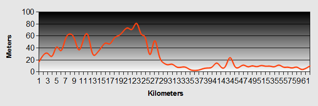
Inverness to Gretna Green - Day 8 - Glasgow to Strathclyde
- Distance 24km
- Max Elevation 60m
Gretna Green to Liverpool - Glasgow to Strathclyde Ride Profile
Ride Description
Today we had to find our Inverness to Gretna route through the Glasgow suburbs on the planned, but not yet sign posted C74 route to Carlisle. It was not easy because although we could see the route on the 1 inch to 1 mile OS map on the Sustrans web site, we couldn't print them. So, we ended up printing Google Maps and then hand copying the route onto these from the Sustrans site.
The first part of the Inverness to Gretna route followed the C75 Glasgow to Edinburgh path along the side of the Clyde, which was swollen and brown from all the rain, with tree trunks and debris speeding down the river. Some of it was pleasant and green but still large sections were dismal and derelict. The pathways were covered with painted graffiti and liberally spread with broken glass. It was a good job that our Marathon tyres could cope with this.
 Glasgow
At around 12-30 we came to Morrison's Supermarket and decided to buy supplies and also take advantage of their ultra cheap restaurant. Whilst Karen did the job shopping, Steve went off, armed with a twenty pound note, with instructions to obtain the lunch. A simple enough task you would think. However, when Karen joined him, he still had not ordered lunch and had managed to lose the twenty pound note. Not once, but twice. Again due to the honesty of these fine Scots folk, it was returned to us twice.
Our map production was successful and we managed to navigate through housing estates, pathways and foot paths to reach the Strathclyde Country Park.
The camp site there is lovely. Cheap at £4.75 per night with good facilities, BUT it lies right next to the M74 motorway so it is only advisable with ear plugs. It was however conveniently close to a pub from where we are writing our blog!
Inverness to Gretna Green - Day 9 - Strathclyde to Abington
- Distance 54km
- Max Elevation 300m
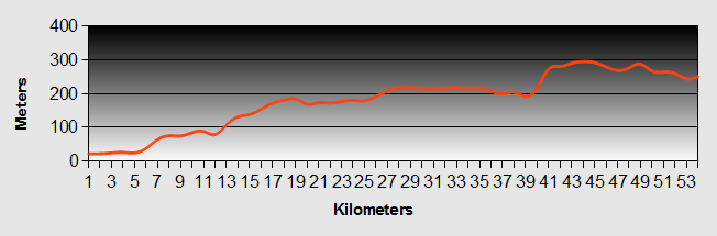
Gretna Green to Liverpool - Strathclyde to Abington Ride Profile
Ride Description
Today's Inverness to Gretna ride was a day of three parts.
The first was finding our way from the camp site to Chatelherault Country Park.
We cycled along the banks of the Strathclyde Loch, which hosts the water sports centre. There were lots of people out running and rowing and it was a pleasant ride, except for the ever present rain. Finding the Inverness to Gretna route was easier than expected as it was being improved with new surfacing and signage.
We had a little bit of a struggle to find our way to Chatelherault, taking a wrong turn up a private driveway, but once put right it wasn't too much of a problem.
Chatelherault was the former shooting lodge of the Hamilton family and had been renovated from a burned out shell in the 1960s. We stopped at the main entrance and one of the park attendants assured us that it was possible to ride the path along the side of the river through the park. We should have trusted our doubt when he said that although he worked here he had not actually walked the path. The path was a great mountain bike track, but was quite muddy, rough and mostly up hill and at one point so steep that we had to get off and push. Not at all recommended for a loaded touring bike.
When we did eventually reach tarmac, we were already wet, muddy and exhausted and it was only 11-00. We still had another 45 km to do.
 Chatelherault Country Park
The second part of todays Inverness to Gretna leg started out quite hilly and when we reached close to the next town, Larkhill, we decided to forsake the C74 proposed route and stick to the main roads. We stopped briefly in Larkhill at "Subway" for an early lunch. We just missed their pre 11-00 breakfast special so ended up spending double what we could have spent. We were mightily pissed off.
The next 20 km on main roads were wet, boring and busy with a fair degree of up hill, but not as much as it would have been had we persisted with the C74 route.
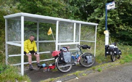
We stopped in Lesmahegow to shop followed by a steep climb out of the town up onto the old and deserted dual carriageway, which used to be the old A74 by pass. Half way along we stopped in a bus shelter for a brew up. Whilst there we spotted a Sustrans sign post and realized that our Inverness to Gretna route was now back on the official C74 route.
Things started to get better as we entered the third part of the ride. The rain stopped and although the Inverness to Gretna route was up hill, it was a gentle gradient on a dedicated cycle path away from the M74 motorway and across open and remote heath land with beautiful views. We arrived at our camp site at Abington, (the highest village in Scotland). It was a bit pricey at £12.50. It was next to the main West Coast rail line and a little way away from the M74 so we were a bit concerned about noise. However our concern proved to be unfounded and we had a good night. For the first time we actually got a dry pitch, but whether or not it was being that bit higher, we noticed it was decidedly colder.
Inverness to Gretna Green - Day 10 - Abington to Kirkpatrick-Fleming
- Distance 74km
- Max Elevation 310m
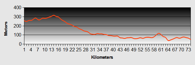
Gretna Green to Liverpool - Abington to Kirkpatrick-Fleming Ride Profile
Ride Description
It was still not raining in the morning and we managed to get a dry pack and were quickly back on the Inverness to Gretna route. We anticipated that today would be a hard day with a long climb up the Clyde valley. It was cloudy but dry and the climb turned out to be an easy gradient with little traffic.
It was a lovely ride to the watershed, but as we started our descent the rain started and the rest of the ride was pretty boring, shadowing the M74. We expected to be able to get lunch at Johnstone Bridge, but there was little there of note and we didn't want to use the motorway services. We carried on and found a lovely pub at the road side, the Horse and Groom ( we think). There was a horse driving event underway, in the most awful weather. We sat in the hotel conservatory and had a delicious Sunday lunch with desert. Fully stuffed, we set off again and after a short interlude in Locherbie to do some shopping headed on expecting to camp in Echelfechan. Although ther name sounds enticing the place itself did not do its name justice. The camp site was wide open and wind swept. There was nobody at reception, just a number to call. The price £15 per night. We told 'em it was too expensive and carried on.
We were glad that we did. We found Bruce's Cave camp site at Kirkpatrick Fleming. As we cycled down towards the camp site over the railway line, at the entrance to the site we spotted Bertie's Burger bar and it was still open (heaven). We rolled into the camp site and the friendly welcome of the lady manager. Included in the very reasonable price was free entry to Bruce's Cave. This is reputedly where Robert the Bruce met his famous spider. Well what can you say. It was a cave with some scribings over the door.
The facilities included a real bath with hot water! Never have we seen a camp site with a bath before, but we made full use of it. Luxury!
Inverness to Gretna Green - Day 11 - Kirkpatrick-Fleming to Dalston
- Distance 32km
- Max Elevation 60 m
Gretna Green to Liverpool - Kirkpatrick-Fleming to Dalston Ride Profile
Ride Description
After a lot of rain overnight, the morning brought the first blue skies that we had seen for 10 days. Despite a leisurely start we were away by 10-00. This proved to be the first day of our Inverness to Gretna trip without any rain.
Before leaving Kirkpatrick Fleming we stopped at the local village garage to test our ability to get our fuel bottle refilled. No problem.
Fully refueled we carried on towards Gretna Green where we stopped at the world famous Old Blacksmiths Forge, the destination of many an eloping couple running north of the border to get hitched.
 Gretna Green
Even though it was early in the day and late in the season, the place was busy with tourists all wanting to have their photo taken at the Gretna Green sign. One Chinese tourist was very interested in our bikes and what we were doing. He insisted on having his picture taken with Steve, like he was some celebrity or something.
 Gretna Green Piper
Karen having a nervous breakdown!...
A short distance out of Gretna, we crossed our first border, into England. Need to buy new flags to replace our Scottish ones. Also for the first time we sat in the midday sunshine and enjoyed a picnic lunch at the side of the road.
 England - Scotland Border
After lunch however, both the weather and the Sustrans route signage deteriorated. We ended up riding some of the distance along the busy A7 into Carlisle. We were wet and fed up with the continued checking of direction. With the help of a local cyclist, we did eventually find a good traffic light route into the center.
We followed his directions to a cycle shop where we could get replacement cycle riding glasses for Karen, who had carelessly leaned on them that morning. No luck. They didn't know how we could find the C7 route out of Carlisle, but didn't even know what Sustrans was. We went back into the town centre to buy a map. Even then we spent a frustrating 40 minutes trying to find our route.
Eventually on the right track we had a pleasant ride out of Carlisle on a traffic free path by the side of the River Caldew to the village of Dalston where we decided to stay for the night at the Dalston Hall Caravan Park. This turned out to be a great find. A lovely peaceful site, next to the golf club and Dalston Hall Hotel. The owners were very helpful and prices were reasonable.
That evening we rang Simon and he told us that according the weather forecast there was the tail end of a hurricane on its way and that it would be very windy and rainy tomorrow.
We were in good spirits though and we had successfully completed the Inverness to Gretna leg of our journey, rain and all.
New! Comments
Have your say about what you just read! Leave me a comment in the box below.