Magnificent Andalucia
Seven Weeks by Bicycle
Andalucia has to be one of Spain's most intruiging provinces, with its rich mixture of Moorish and Christian cultures. After taking a 2 month break in the lovely town of Lubrin in the Sierra de Los Filabres we set off on a seven week tour of education around the central and eastern areas of Andalucia.
We would climb up to 1400 meters in the cold of the Alpajuras hills and visit the beautiful, historic cities of Granada, Cordoba, Jaen, Baeza and Ubeda, before cycling through the magnificent Corzola national park.
Getting There
Being circular, the route can be started from any point. Getting to your start point by car is one option. Buses and trains are less easy in Spain if you have a bike. So if you do not drive then probably the best way is to arrive by air. You can fly in to Almeria, Granada or Cordoba to start the route. If you would rather have the beach and some good single track riding, a good alternative is to fly into Malaga and stay at Fuengirola. There are some great deals to be had on group mountain biking tours in Andalucia. This one offered by Real Adventures takes in some great scenery, wonderful single track and still lets you while away some time on the beach.
Schedule
- Lubrin to Tabernas
- Tabernas to Fondon
- Fondon to Laroles
- Laroles to Trevelez
- Trevelez to Pitres
- Pitres to Orgiva
- Orgiva to Dilar
- Dilar to Monachil
- Monachil to Alomartes
- Alomartes to Castillo de Locubin
- Castillo de Locubin to Jaen
- Jaen to Zuheros
- Zuheros to Lucena
- Lucena to Rute
- Rute to Alameda
- Alameda to Fuenta de Piedra
- Fuenta de Piedra to La Guijarossa
- Guijarossa to Baena
- Baena to Andujar
- Andujar to Mengibar
- Mengibar to Banos de la Encina
- Banos de la Encina to Baeza
- Baeza to Ubeda
- Ubeda to Cazorla
- Cazorla to Parador El Adelantado
- Parador El Adelantado to Coto Rios
- Coto Rios to Montillana
- Montillana to Garrotegordo
- Garrotegordo to Santiago de la Espada
- Santiago de la Espada to Huescar
- Huescar to Baza
- Baza to Olula del Rio
- Olula del Rio to Lubrin
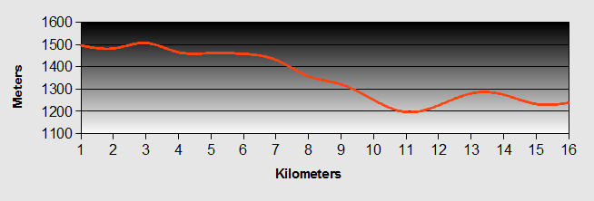
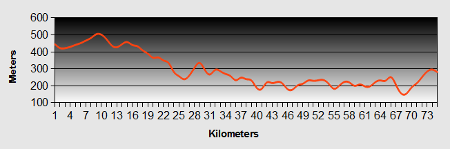
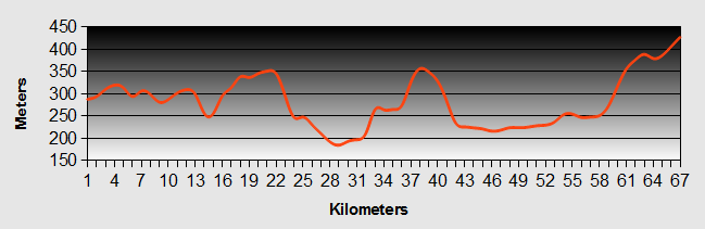
Our ride descriptions give an account of the ride that we completed. As part of the description we also provide links to Wikiloc or Google maps and elevation profiles based on mapping data available through the internet. The ride profiles are smoothed to give what in our opinion is a more beneficial view of the profile. We use paper maps, GPS and on line data to plan and conduct our rides. We are happy for you to use our descriptions, but be aware that we do not guarantee the accuracy of the information provided as situations surrounding any ride change over time.
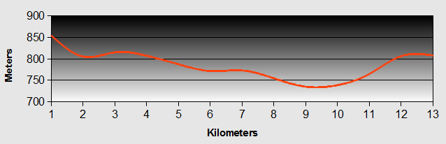
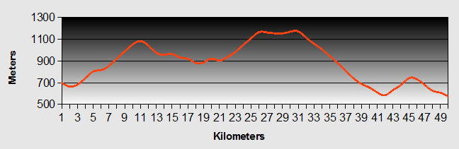
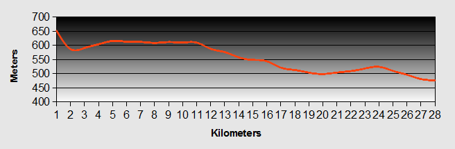
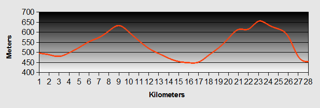
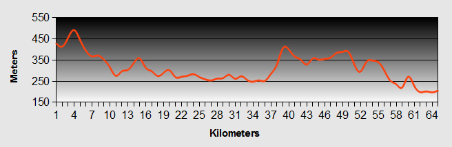
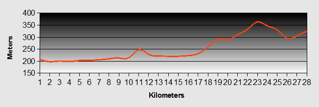
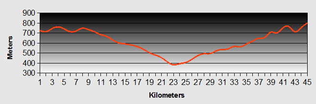
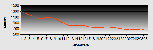
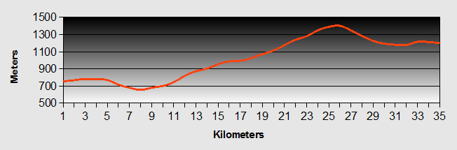
Andalucia - Day 1 - Lubrin to Tabernas
- Distance 42km
- Max Elev 703m
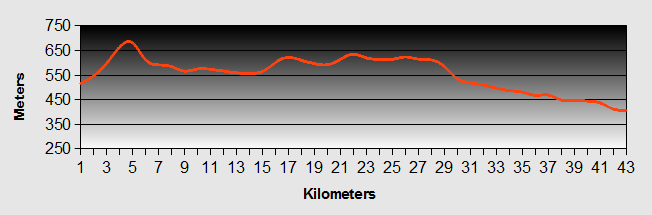
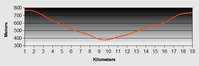
Andalucia - Lubrin to Tabernas Ride Profile
Ride Description
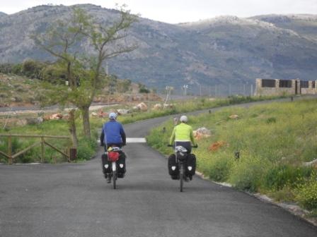
It was nice to be back on the road again after 4 months of sedentary life style in Tavira and Lubrin.
As we set off from Lubrin, we stopped to say goodbye to Jaquinto (the tailor) who thought we were "poco loco". The sky was blue but there was a strong head wind as we committed to our first climb, out of Lubrin towards Uleila del Campo, a nice easy ride along a flat plain and quite road, stopping in the village for a coffee.
We continued along the flat or down hill to reach the main Sorbas to Tabernas road. This route is a little more busy with a few heavy lorries, but still the ride was enjoyable. After an easy first days ride we arrived in Tabernas and found our accommodation for the night, the Hostal Avenida, which was clean and comfortable at just 35 euros per night.
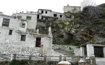
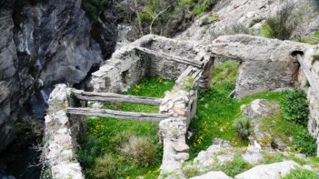
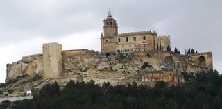
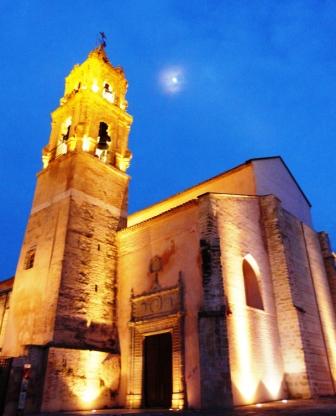
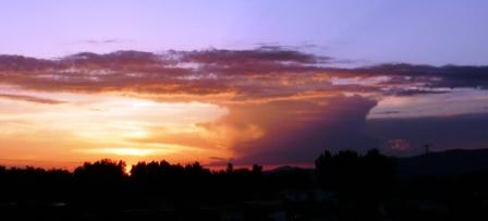
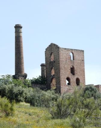
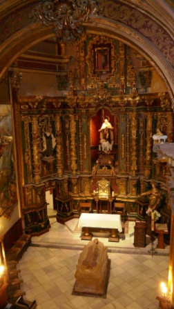
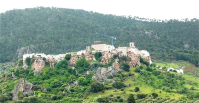
In the afternoon we took a walk up to the old Moorish castle that overlooks the town.
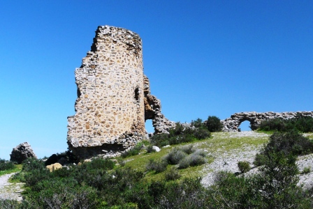
Time and conflict has ravaged the castle and the only thing that remains of the original is half a tower and a few wall ruins. The authorities have rebuilt some of it in the original style to give an indication of what it must have been like.
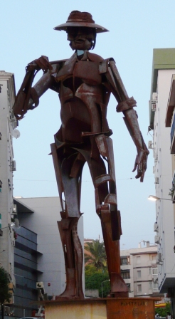
Tabernas is famous for its spaghetti western filming industry. The desert around the town was used to film the spaghetti westerns with Clint Eastwood. This seems to have long since passed, but today the old film sets continue as tourist attractions, known as Mini Hollywood.
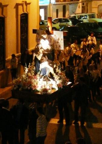
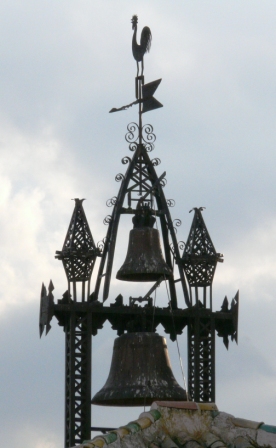
In the evening we sat in a bar eating our dinner, overlooking the square in front of the church.
Suddenly we heard the beating of drums and one of the Easter processions was making its way down the main street, finishing at the church. We quickly finished our dinner and went out to catch the end of the procession.
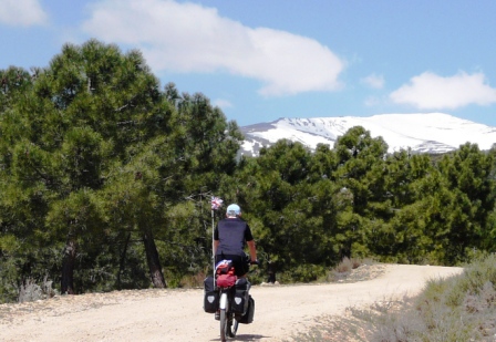
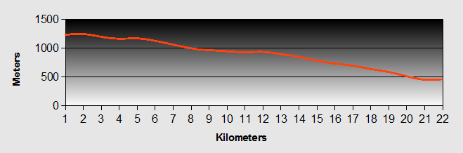
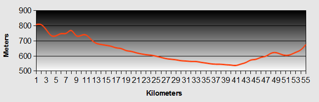
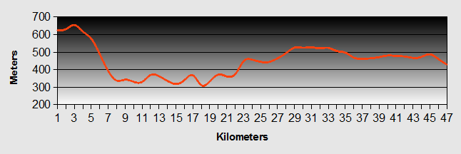
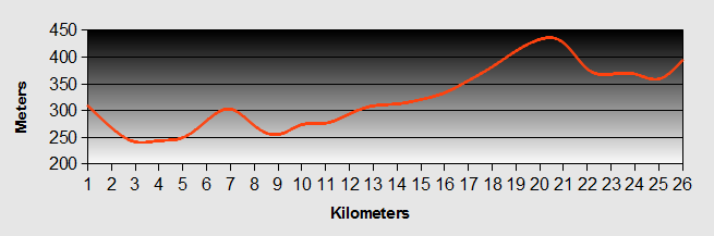
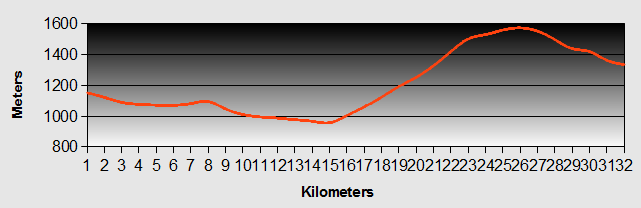
Andalucia - Day 2 - Tabernas to Fondon
- Distance 60km
- Max Elev 1044m
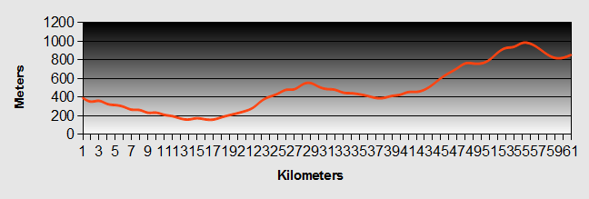
Andalucia - Tabernas to Fondon Ride Profile
Ride Description
Our second day was to be a long one and would be the first of our climbs up into the Alpujarras, the pre curser to Andalucia's Sierra Nevada National Park.
The ride from Tabernas was nearly all downhill following the motorway down towards the coast and Almeria. We hardly pedaled for several kilometers, before turning off towards the small town of Paulenca. The town lies at the lower end of the Andarax valley, which eventually reaches the sea at the coastal resort of Almeria. Although not as well known as Guadix, it also has a number of cave houses. Being a bit lower than Lubrin, the orange trees were blossoming and the scent was heavy in the air as we wound our way into town. Here we turned up the valley and started our gradual climb.
We wound our way up the main N324 road towards the spa town of Alhama de Almeria. Near the end of our climb we happened across the Los Millares. We called in at the visitor centre to learn a little more of this historical site.
Los Millares is considered one of the most important European archaeological sites of the Copper Age. It covers a vast area on a spur between the Andarax River and the Rambla de Huechar. This position provided excellent natural defences, close to the copper mines of the Sierra de Gador. The villages were well fortified with several walls and lines of forts to control the territory that was not protected by the gorges on the other two sides.
The Necropolis lies outside of the main village and comprises of approximately 80, poorly preserved tombs, one of which has been recreated to show what they were actually like. The members of the same clan would be buried here along with their personal goods, many of which can now be seen in the Almeria Museum.
We walked around the ruins in the warm sunshine as bees and insects buzzed around the natural flower meadows on the uncultivated ground between the ruins. The feeling of standing in the middle of this village, which thrived nearly 4000 years before Christ was a humbling one.
After this brief interlude we continued on, turning off the Alhama road for a long downhill back into the Andarax valley, which is very green and cultivated. Arriving at Tarique we stopped by the side of the rambla, flooded with spring snow melt waters, to eat our packed lunch.
We then had a steep, first gear climb back up the valley side to join the N348 at Illar. The ride was pleasant until we reached Canajayar. Here the road was a superb, typical Eu funded highway with long straights and sweeping curves at a constant 8% gradient. We actually find these to be the worst type of hill. You seem to make very little progress. They are demoralising and sap your will. The climb went on and on.
We stopped to brew up at one point. At each brow we were convinced that we had reached the top only to find the road winding ever upwards. The last 10 kilometers were numbing and we were only driven on by the need to reach our camp site. Finally after about two hours we crested the top and enjoyed the brief, fast descent down the other side to reach Fondon.
To get to the camp site we had to cross over the river, which was in full flow over the ford and impassable on our bikes. Instead, we had to unclip all of our panniers and carry them and the bikes up some steps and across the river on a rickety and swinging, cable suspension foot bridge.
The Puenta Colgante site is the first camp site in the Alpujarras, approaching from Almeria. It is close to the village and the setting next to the river is nice. It is basic with gravel based pitches. The toilets were reasonably clean, but only had hot water in the showers, not the hand-basins. Of course it was too cold to use the pool, which was closed anyway. There was a bar / restaurant on the site, but they were both closed. The price was 3.5 euros per adult + 3.5 for the tent and 3.5 for services = 14 euros per night total. Expensive for the standard of what was provided, but we figured it would pretty much be what we would have to expect.
The pitches were marked, but most of them were reserved by Spanish families and had a variety of caravans, awnings, sheds, covered sitting areas, etc. It all felt a bit like being in a shanty town. You got the feeling that it needed some love and attention. In the summer it would be a manic place to camp. We were not impressed and wouldn't recommend it. There is in fact another site at La Molita about 4 kilometers further up the valley signposted off the road just before Fuenta Victoria. We didn't have a chance to see the camp site, but the town certainly has more facilities than Fondon.
The following day we slept until the sun rose at about nine. It was cold (there was thin layer of ice on the table), but quickly the temperature increased. We took the well signposted tour around Fondon village, bought very cheap veg and fish and spent most of the afternoon feasting, writing the blog and researching our route for the next 6 weeks.
In the evening we ate at a restaurant in Fondon (full menu del dia including wine and coffee for only 9 euros). Here we met Jacob who was cycling around the Sierra Nevada, on a weeks holiday from the Nederlands, having flown into Almeria that morning. He was averaging 70 km / day so it was likely we wouldn't see him again.
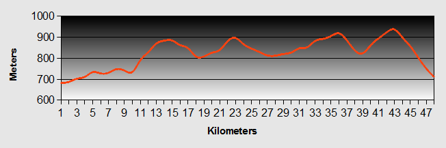
Andalucia - Day 3 - Fondon to Laroles
- Distance 45km
- Max Elev 1731m
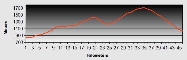
Andalucia - Fondon to Laroles Ride Profile
Ride Description
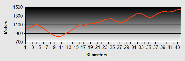
In the morning we had a leisurely start, said goodbye to Jacob and headed off up the valley towards Fuenta Victoria. It was warm and sunny with a chilly breeze which just reminded you that it was still only April. We rode slowly up the Andarax valley which was a gradual climb until just after the village of Laujar de Andarax. As we exited the village a large LED road information sign said "Extreme Precaution!" It was presumably left on from when the roads had been icy. However the only thing that we did experience were the many landslides that we saw throughout our whole ride, this being the result of the worst Spanish winter in the last forty years.
Finally the road started to climb up some serious hairpin bends, which are much preferable to the long sweeping curves of the highway that we had cycled two days before. We climbed and climbed, through scrub and scattered pine trees to the mountain village of Paterna del Rio and our fist coffee stop. We sat and listened to the old gentlemen chatting in the village, trying to discern what they were talking about.
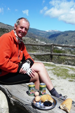
From here we reached the highest point of our climb, getting tantalizingly close to the snow line.
We stopped to eat lunch in the pine trees before an enjoyable descent to Bayercal, the highest village in Almeria Province at 1255 meters. The village is set in the side of a deep gorge. We dropped down into the gorge before climbing back up the other side in the lowest gears, to reach our next camp site on the outskirts of the Laroles village.
The camp site in Laroles is much nicer than that in Fondon with nicely separated grassy pitches and some tree cover. As it was out of season, even though it was Easter, the pool, bar and restaurant were all closed. Not that it bothered us. There were few people on the site and we were pleased to have some real peace and quiet. They did however charge us per adult, tent and can you believe, our bicycles, but the total price was the same as the last site at 14 euros per night.
The village spreads along and down the side of the steep valley slope. Its bars and shops are equally spread out and carrying shopping back up the hill to the camp site certainly stretches those calf muscles.
In the evening we ate great pizzas in the Manitos cafeteria, next to the petrol service station. It overlooks the valley and we would recommend it.
The next day we relaxed about the camp site, doing a few little repairs and our washing, lying in the sun reading and not a lot else.
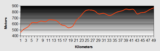
Andalucia - Day 4 - Laroles to Trevelez
- Distance 49km
- Max Elev 1534m
Andalucia - Laroles to Trevelez Ride Profile
Ride Description
The road tracks the lower slopes of the Sierra. As it does, it crosses deep gorges that cut through the slopes.
On this day we crossed four of them each with a significant descent and a long hard climb, but the scenery is stunning and the villages are delightful.
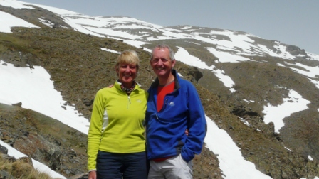
We stopped at a view point for lunch, looking towards the remnants of snow on the mountains.
The final part of the ride was a long steady climb up into the Trevelez valley. The weather had got colder. Trevelez is famous for its Jamon, but we couldn't carry a whole leg on our bikes. Of course as sod's law would dictate the camp site was on the far side of the village with another long climb. It was worth it though. The site is run by Alex and Ricardo and their two lovely little girls. They are both climbers and run the site with a nice relaxed atmosphere. There is a nice restaurant and bar where we sampled for the first time the famous Alpujurran, which is a grill comprising morcilla (black pudding), chorizo sausage, fried egg, patatas pobre (poor man's potatoes with green pepper and lashings of olive oil).
The following day we took time out to explore the village, shop and do some washing. The town is divided into three parts, Barrio Baja is the lower area where all the tourist buses stop and full of tourist shops and bars.
Barrio Medio is the historic part of the village with the church and traditional narrow streets, bars and shops.
Barrio Alta is the highest part of the village, a lot of which is still in its original state. Right at the top is an old Cortijo, as yet unconverted.
The next day we wanted to climb to the higher mountains and Karen had planned a nice round route up onto the ridge and back to the village. We set off through Barrio Alta following an old winding donkey track up the steep mountain side.
It was warm and sunny and after 2 hours we reached wide stretches of snow which covered the path and required more than the training shoes that we were wearing to traverse them.
Reluctantly we decided that we couldn't go any further.
We sat and ate lunch marveling at the majesty of the peaks and the snow around us before returning the way we had come.
Andalucia - Trevelez to Pitres Ride Profile
Ride Description
The ride to Pitres was an easy one being mostly downhill, following the Trevelez valley, only starting to climb again when we neared Portugos. We stopped there to buy our provisions and then continued to our stop for the next couple of days the camp site at Pitres. The site was reasonable, but as per usual at this time of year most of the facilities were closed.
In the afternoon of our arrival we cycled part way into the Trevelez gorge to some of the small and very traditional villages in the area known as La Taha.
A lot of properties have been bought by expats as well as locals and tastefully restored in the traditional style. Many of the streets in these villages can only be accessed by foot. If you are visiting the Alpujarras then this is the area to visit for authenticity.
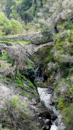
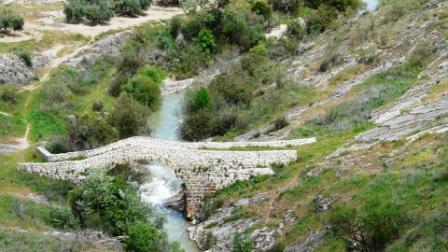
The next day we rested the bikes and set off to walk through these same villages and further down to the bottom of the Gorge where you find the ruins of an old flour mill...
...and a narrow bridge over the river.
From here the old donkey transport route path is now the GR142 footpath and hugs the side of the valley as it works its way up to reach a 4WD track that cuts back following the ridge of the Cuatro Picos. The GR142 continues to Orgiva, but a hand painted notice on the footpath sign, warned that the next bridge over the river was washed out by the floods. This is the bridge that is described by Chris Stewart in his book about his life in the Alpujarras, "Driving over Lemons", which Karen was in the middle of reading and enjoyed immensely.
Just as the track joins the road a path leads off left back down into the valley.
The path is centuries old and zig zags steeply down. The stones are worn by the feet of many donkeys as well as the elements.
At the river crossing is another old mill, bigger than the first. Evidence can be seen of the original mill train feeding water from further up the river to drive the wheel. The bridge crosses back over the river, which thunders past some thirty feet below through a crevis only about 12 feet wide.
The valley was full of beautiful wild flowers from common daisies and buttercups to rare orchids and grape hyacinths.
Turning back down the valley we strolled back through the terraces to La Taha. In places we had to assume the abilities of mountain goats to negotiate the path that had been washed away by landslides.
We missed out on a reviving beer at the bottom as the bar was being redecorated. So we only quenched our thirst after we completed the final ascent back to Pitres.
That night we enjoyed a meal with Tina, Espen and their ten week old son Silas who had travelled down from Denmark in their campervan.
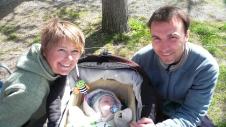
We chatted late into the evening and retired to bed when it became too cold to sit any longer.
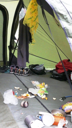
We left the unwashed pots outside the tent. An hour or so later we were woken up by the farm dog licking the pots. Just as we were nodding off again, we were woken by the camp site donkey which had broken loose from its tether. He also licked the pots grazed, clomping around the tent. Just as we were falling to sleep again, he brayed very loudly, right next to the tent. Steve nearly shot through the tent with the shock.
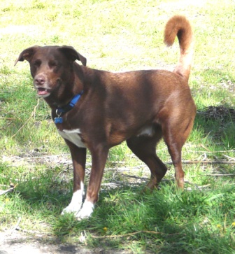
Whilst at Pitres we also came across a lady with a dog called Coco that was just like our old dog Sam.
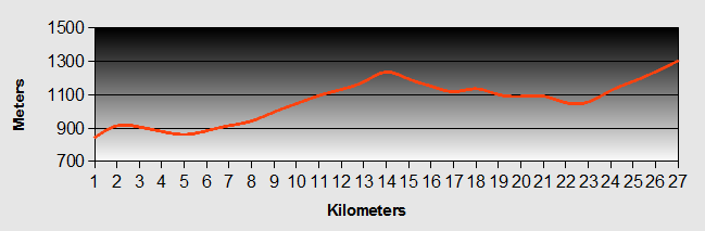
Andalucia - Day 6 - Pitres to Orgiva
- Distance 21km
- Max Elev 1257m
Andalucia - Pitres to Orgiva Ride Profile
Ride Description
We had an easy day again, downhill all the way, stopping at Pampaneira for coffee. Suddenly we were in the tourist part of the Alpujarras, with bus loads of tourists, gift shops and expensive bars. We moved quickly on arriving in Orgiva.
We had been warned that Orgiva had been reasonably nice several years ago and had been a bit of a hippy haunt, but now there are a lot of alcoholics and drug users that sleep on the streets. It was not one of the nicest places.
We camped at Camping Orgiva just out of the town, a well run site with good grassy pitches and nice restaurant.
In the afternoon it was time to get a haircut by Juan Pedro who was a barber rather than a city boutique hairdresser. Karen didn't quite get a "Sigourney Weaver". With little communication he did a reasonable job on both of us.
Andalucia - Day 7 - Orgiva to Dilar
- Distance 49km
- Max Elev 878m
Andalucia - Orgiva to Dilar Ride Profile
Ride Description
We knew that today was going to be a long day and potentially a hard ride. To start with we had a hill out of Orgiva, before descending to Lanjaron, our first coffee stop. Lanjaron was also quite touristy, but had a much nicer feel to it than Orgiva. It is a spa town and had many nice shops, bars and restaurants.
From here we had another long downhill all the way, passing over the Granada to Motril Motorway to the small village of Beznar. Then it was down to the low gears for a long slow drag back up again to cross back under the motorway at Niguelas. We were passed by a number of road cyclists who all greeted and encouraged us. One of them tapped both Karen and I on our hand as he went past, which really helped our motivation.
After a lunch near Niguelas we continued along the main road, which was quite busy and the ride was not a particularly notable one. We stopped in some random town for icecream as it was very hot.
Finally we approached the suburbs of Granada. We decided not to stay at the Supspiro de Moro camp site (by the side of the motorway!) and continued through sprawling urbanization that formed the feeder estates of Granada. We rode quickly through to the village of Dilar in the foothills of the Sierra Nevada with views of Mulhacen in the background.
We stopped at a bar at the bottom of the hill leading into the village to ask for directions to the camp site. She advised us that it was closed, but she could offer us a room for 20 euros. We jumped at the chance of a real bed.
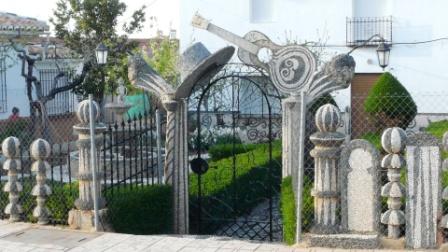
We walked around the village in the evening and found this strange house.
The garden had been decorated with white and black pebble mosaics, the most spectacular being this guitar and hat over the gate.
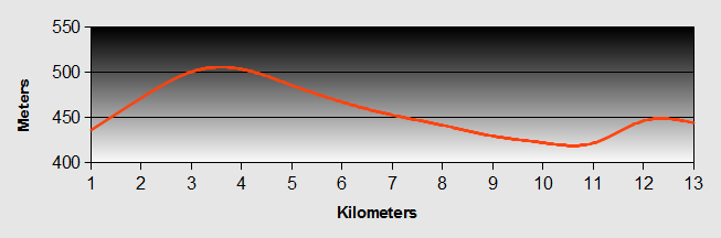
Andalucia - Day 8 - Dilar to Monachil
- Distance 13km
- Max Elev 878m
Andalucia - Dilar to Monachil Ride Profile
Ride Description
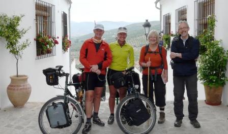
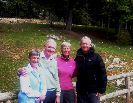
We rode through the suburbs of Granada to reach our hotel in Monachil, where we had arranged to meet our friends Ann and Alan Hoggarth. Before checking in we rode into Monachil village that lies at the foot of the hill leading up to the ski resort further up the mountain. After a quick scout around and a coffee, we headed back to our accommodation. The Hotel was very nice, small, quiet and family run. The owners made us feel very welcome.
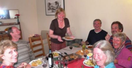
That night we went to dinner with Alan and Ann and caught up on all of the gossip from our old home village, Thornton Dale.
It was lovely to see some old friends and to be able to converse in English about things we were familiar with. Alan and Ann had bought us some "treats" from the UK, namely porridge and Yorkshire Tea Bags.
Andalucia - Day 9 - Monachil to Alomartes
- Distance 54km
- Max Elev 824m
Andalucia - Monachil to Alomartes Ride Profile
Ride Description
Alomartes is the village where Dave, the guy we met at Trevelez camp site, runs a B & B with his wife Irene. He had arranged for us to stay there at a reasonable price.
We said our goodbyes to Ann and Alan and set off, retracing part of our route through the Granada suburbs. The days ride was physically quite easy, but was a mentally challenging, navigating our way around the west side of Granada, through various villages which have been absorbed into Granada and consequently they no longer have their old world charm nor any useful road signage.
Our route took us through La Zubia, Ogijares and Armilla. After this we picked up a bicycle track which took us all the way through to Santa Fe. We had planned to cut around the south of the small urbanization of Santa Fe to pick up a track by the side of the Canal del Cacin to Moraleda de Zafayona, but we were advised by a local that we couldn't get that way. Instead we headed back to Santa Fe but were thwarted again as we could not find a way to cross the motorway. We cut off through an industrial estate and miraculously found a bike bridge over the motor way into the small village of El Jau.
With the help of a jogger who was pounding down the road, we found a rough track on the banks of the river Genil and followed it west to Chauchina, where we stopped for lunch.
The road took us through Valderubbio, Escoznar and eventually into Alomartes. Although the ride was not through particularly scenic areas we really enjoyed the challenge. It was a bit like being on a treasure hunt, finding our way through the poorly signposted suburbs with the help of some rough notes which Steve had made from the Google map.
We arrived in Alomartes at about 4.00pm only to find that Irene was not at the house. A neighbour advised us that she had taken the dog for a walk so we nodded off in the hot sunshine in the village plaza until her return at 5-30.
That night we walked up the road to find somewhere to eat. There was only one bar/restaurant open so we went in for a beer. We asked about food and were directed to the cook who was sitting drinking at the bar. She gave us a very detailed verbal description of the menu, about 70% of which we could not understand. The food was very good, cheap and generous amounts but we made the mistake of choosing a rather nice looking bottle of wine without actually asking the price. It was superb but cost 20 euros.
Andalucia - Day 10 - Alomartes to Castillo de Locubin
- Distance 47km
- Max Elev 945m
Andalucia - Alomartes to Castillo de Locubin Ride Profile
Ride Description
We bid goodbye to Irene and set off through Allora towards the main N432 to Cordoba. We had decided that as we needed to cover a good distance today it would be better to avoid the steep winding side roads. We were rewarded by very rapid progress along the road, which was quite busy but had a good smooth surface and wide hard-shoulders. Within 2 hours we had covered 37km.
As we rounded the final bend before Alcala de Real we got our first sight of the spectacular castle, set high on a rocky outcrop above the town.
Karen was determined to see the castle so set off on the climb up the steep cobbled streets to get to the top of the hill. Some parts were so steep that we had to get off the bikes and push. We arrived hot and breathless at the entrance to find we had just missed the morning opening times and would have to wait until 3.30pm to get in. Never mind, it was a good picnic place with fine views and saved us 10 euros in entrance fees.
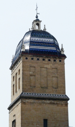
Fed and watered we zoomed back down the hill to explore the old town and the headed off up yet another long climb to Castillo de Locubin. This was another of those old Moorish towns, set high on a hill with impossibly steep and winding cobbled streets where you can't find anything. We had seen the large central church from high on the hill but once in the town couldn't even see the unique bell tower.
We stopped and asked for directions to accommodation and were relieved to find a nice, the new Hospederia Locubin at the bottom of the hill.
This area of Spain is famous for its cherries and we started to see cherry trees with white blossom in full flower, scattered among the olives and almonds.
That evening we walked up to the town and into the plaza which was full of families, teenagers and oaps enjoying the evening sunshine. In the bar we met an English couple who owned a house in the village and enjoyed a few drinks with them. After they went home we ordered a 'raciones' to share and learned a lesson to always ask the price of the food before ordering when the barman charged us 12 euros for this which should only have cost about 5 euros.
Andalucia - Day 11 - Castillo de Locubin to Jaen
- Distance 48km
- Max Elev 1196m
Andalucia - Castillo de Locubin to Jaen Ride Profile
Ride Description
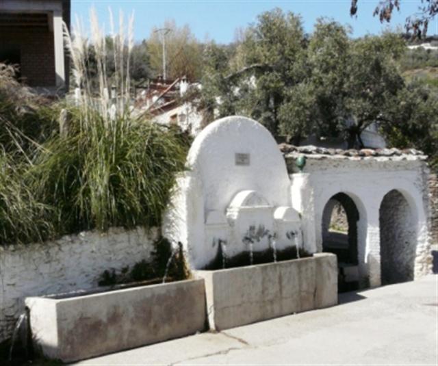
We rode out of Castillo de Locubin heading up the valley on the road to Valdepenias. The valley was lovely lush green with lots of small vegetable plots by the river. Before we started our real ascent we cut off left to visit the Naciemento de San Juan , which looked very pretty in the photographs, but was a bit disappointing when we got there. It was only a 4 km detour and we retraced our tracks and started a long climb of some 9km up the valley reaching the saddle at about 1250m. The ride was lovely but tiring. After nearly three hours riding we could still look back down the valley and see Castillo de Locubin.
Dropping down to Valdepenias we stopped for lunch in a small cafe, did some shopping and headed out of town on another long climb to the Sierra de la Pandera. Having reached the highest point we had a wonderful descent through hairpin bends and lovely valley to reach Los Villares.
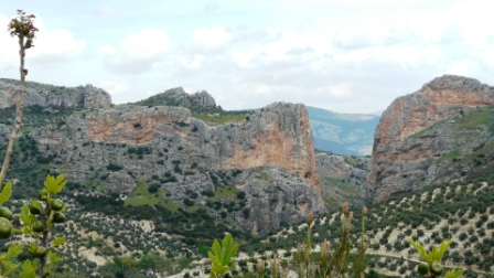
We bypassed the town and carried on up the last ascent on another modern long sweeping road.
We stopped halfway up to admire the view of a cleft in the rock face through which the Rio Guadalbullon runs to join the Rio Gaudalquivir that eventually wends its way to Cordoba.
As we came over the crest of the hill we had superb views of Jaen city and the wonderful cathedral.
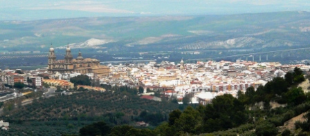
We stopped for a beer and asked for the nearest accommodation, which turned out to be just 500 m down the road. It was a privately run www.lacaseriadepiedra.com . A bit outside our price range but hey, what the hell!
That afternoon, we went into town on the bus to find out about the Via Verde that we would take the following day and to look at the cathedral.
Andalucia - Day 12 - Jaen to Zuheros
- Distance 78km
- Max Elev 667m
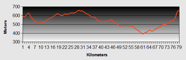
Andalucia - Jaen to Zuheros Ride Profile
Ride Description
We awoke to find that there was no water in the bathroom and when we went to enquire, us and the other guests couldn't find the owners, who appeared to be still in bed.
After about half an hour the owner appeared looking disheveled, obviously having only just got out of bed. With screwdriver in hand he proceeded to explain that he was trying to fix the water, apologised profusely and rushed into the kitchen to get us our breakfast.
We had good instructions to reach the start of the Via Verde, cycling, through the steep cobbled back streets on the west side of Jaen, around the base of the castle walls.
There are over 1700km of Vias Verdes (green ways) in Spain, usually formed from old railway tracks. They can be found at http://www.viasverdes.com/ViasVerdes. Our route would take us along the old Tren del Aceite (Olive Oil Train).
At the start of the route were two Vias Verdes guys in a white van, handing out leaflets about the route. This van seemed to dog us all the way to Alcaudete, appearing like the secret police at strategic points along the line. We weren't sure if they were making sure that we didn't pitch our tent for the night or just that we were managing the route Ok.
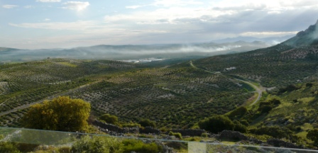
The line was a gradual uphill all the way to Martos with a corresponding downhill all the way to the Cordoba provincial boundary. We rode continuously through olive groves as far as the eye could see. There was no other form of agriculture or grazing and the constant smell of olive oil production seemed to fill the air.
We went through several short tunnels and impressive bridges over deep valleys, the most beautiful of which was the Rio Viboras.
As there was no grazing here the flowers were particularly beautiful. We passed through cuttings with banks of pink orchids, miniature blue irises and lots of other wild species.
Once we crossed the Rio Guadajoz into Cordoba province, the farming was less olive intense and more varied, with goat herds and other agriculture.
We had planned to stay at Luque, but an old information board showed a camp site at Zuheros so we pressed on. However, when we reached the site it was closed.
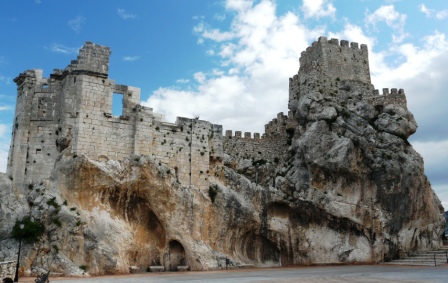
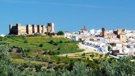
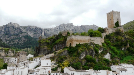
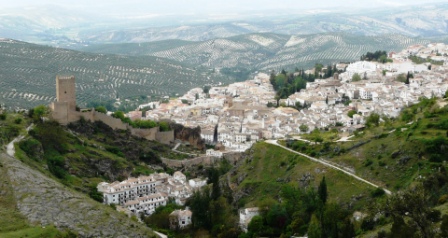
The first sight of Zuheros was impressive, nestling in a fold of the mountain side.
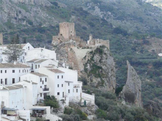
The 9th century castle dominates the town standing proudly on a rocky outcrop, which must have provided a great defensive position.
Of course you cannot experience great beauty without the pain and the ride up the 20% hillside was killing. The only hotel was full and everything else was closed. We were so disappointed because we wanted to stay in this lovely little town. We sat and drank a beer when the phone rang. It was our son Ben who proceeded to depress us even further, telling us that he and his girlfriend had decided to postpone their wedding.
The waiter at the bar recommended a Hostal back in the direction we had come, but in the foot of the valley.
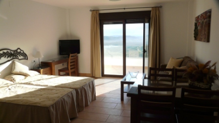
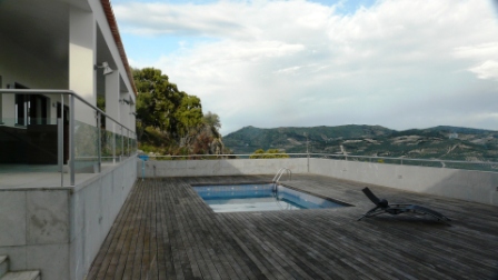
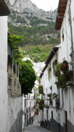
On the way we spotted the www.loscastillarejos.com apertementos rural. They looked expensive, but we stopped and asked anyway. As it was late (8-00pm) the owner Paulio gave us a special price of 45 euros. The apartments were fantastic, brand new with views to die for. The pictures here say it all.
Our host was generous and even gave is a lift back into Zuheros to the restaurant. We had a delicious meal of suckling pig and goat cutlets before walking the 2 kilometers back to the accommodation. It was dark and we used our head torches ( we knew what Spanish drivers can be like at night). Seeing an approaching car we jumped into the ditch at the side of the road. The car slowed to a halt and we climb out of the ditch. It turned out to be the Guardia Civil. To them it must have looked like we were a couple of vagrants up to no good. It didn't help when Steve shone his head torch straight into the eyes of the policeman.
Andalucia - Day 13 - Zuheros to Lucena
- Distance 27km
- Max Elev 673m
Andalucia - Zuheros to Lucena Ride Profile
Ride Description
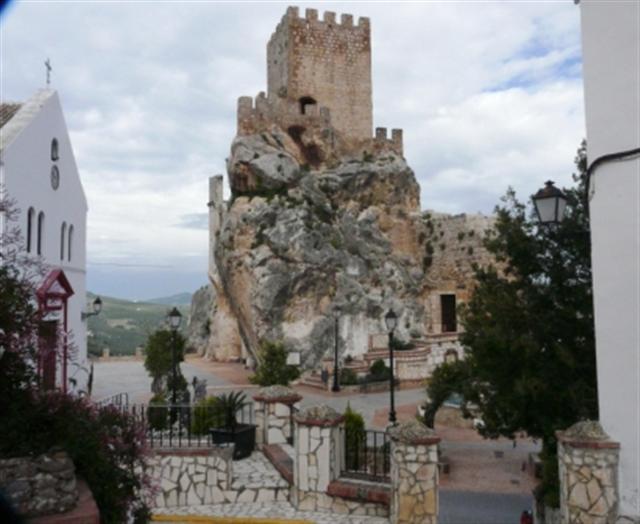
We sadly left our apartments...
...and took a few last photos of the amazing castle at Zuheros.
Today we had arranged to meet our friends, John and Mary in Lucena for lunch. So, it was to be a short easy ride, further along the Via Verde. We set off with plenty of time. As we cycled we could see the dark clouds forming and the rain started as we approached a short tunnel.
The temperature dropped so we donned our wet weather gear and sheltered in the tunnel mouth as a tremendous thunder storm raged outside for about 40 minutes. We were now up against the clock.
We continued on, but the rain had made the going harder. The countryside was beautiful, but we had little time to stop and admire it. The surface of the Via verde in Cordoba province was not in such good condition as that in Jaen province, and there were a number of land slips that we had to negotiate. Over the last 5km the surface deteriorated even more. It was thick sticky clay which coated our tyres, clogged our brakes, mudguards and covered our legs and panniers.
We rode into the outskirts of Lucena, not in a fit state to eat lunch anywhere. Fortunately we spotted a high pressure car wash. Jose Manuel was really keen to help us. We stripped the bike of panniers and gave the whole a lot a good wash. It cost 5 euros and 30 minutes. Jose Manuel apologized for his "poor" English, which was better than our Spanish and offered to converse in Chinese. We were skeptical. He went to show us proof. Out came a pamphlet with Chinese title, which he translated as The Watchtower, proudly explaining that he was a Jehova's Witness.
Still not quite as clean as we should have been we arrived 20 minutes late in the main plaza to find our friends. We had an enjoyable meal, swapped stories and a generally had a good time. After lunch we found www.pensionsaradelucena.com which was basic, but clean and cheap at only 30 euros per night.
Andalucia - Day 14 - Lucena to Rute
- Distance 28km
- Max Elev 678m
Andalucia - Lucena to Rute Ride Profile
Ride Description
After yesterday's experience we decided to give the last 20+km of the Via Verde a miss and instead head south to a camp site on the edge of the Emblas de Iznajar (reservoir). Once we left town, the ride was on a long, busy and straight road until we reached Zambra where we stocked up with provisions.
Rute is famous for its Anis production, but as neither of us like the stuff we didn't stop to sample it. We followed the signs to the camp site but misunderstood one of the signs and ended up 5km downhill in the wrong direction. Backtracking we stopped for lunch at a large derelict house and outbuildings. A part of it was an old olive oil production facility, with the original grinding stones, machinery and tile lined vats in the floor.
We rode back up the hill and enjoyed a descent to the pine clad shore of the reservoir. The La Isla camp site was quiet with only hard gravel pitches, but the bar was open.
We had planned to stay for two nights. That afternoon we walked by the shore and were disgusted by the amount of plastic litter both in the woods and in the water. There were great rafts of plastic bottles, polystyrene, bags and other rubbish floating in the inlet. It was simply appalling.
It was the first time we had any rain so we could see how the new groundsheet performed.
At about 5-00am some joker came down to the shore, parked his car and started playing "boom boom" music at full volume on his car stereo. We didn't get much sleep after that and so we decided that we would move on.
Andalucia - Day 15 - Rute to Alameda
- Distance 47km
- Max Elev 678m
Andalucia - Rute to Alameda Ride Profile
Ride Description
John and Mary were staying at their friend's (Maureen and Patrick) place in Alameda and we had an open invitation to visit them. We decided to head on over and stay the night there. Maureen arranged a nice B and B, run by Steve and Ellie in the village.
The journey was easy through rolling flat countryside and we arrived there at about 5-00pm. The accommodation was comfortable and that night we had a good dinner and played silly games with our friends.
Andalucia - Day 16 - Alameda to Fuenta de Piedra
- Distance 13km
- Max Elev 508m
Andalucia - Alameda to Fuenta de Piedra Ride Profile
Ride Description
Fuenta de Piedra was a lovely town with an air of affluence about it, probably due to the Laguna and the fact that it is a spa town. It seemed welcoming. There was a significant British contingent.
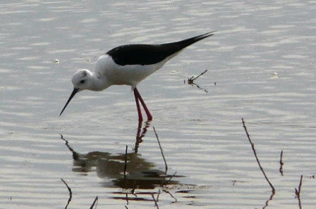
We wanted to visit the Laguna at Fuente de Piedra. The Laguna is a salt lake and is the home of many flamingoes and other wading birds...
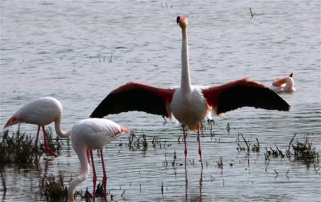
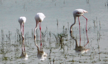
www.camping-rural.com seemed very nice although it was a bit pricey, charging for the bicycles as well as the people (total 18 euros). Despite this we decided to stay for two nights and paid in advance. In the afternoon we took a pleasant ride to the visitor center on the Laguna and watched the flamingoes.
Later in the evening as we cooked our dinner, they flew overhead, in V formation, just like the pink footed geese in Scotland, only with longer legs.
At about midnight, we were awoken by several vehicles arriving at the camp site, banging doors, unloading equipment, loud voices, etc. After 30 minutes of this it went quite, but we were woken again by the same thing at about 5-00am. This time it went on for about an hour and it took us even longer to get back to sleep. It was gone nine before we rose to find out that it was a group of failway maintenance workers on the night shift. Realising that it would probably be the same the next night we decided to leave and asked for our money back. No apology was given for the noise and we were only given a 10 euro refund reluctantly. Needless to say we do not recommend this camp site.
Andalucia - Day 17 - Fuenta De Piedra to La Guijarossa
- Distance 75km
- Max Elev 508m
Andalucia - Fuenta De Piedra to La Guijarossa Ride Profile
Ride Description
If round the World cycling could be as easy as this we would be have way round by now. The roads were flat, we had a back wind, it was warm and sunny. We hardly pedaled at all for the first 40 kilometers. The only drawback was that the road was busier than expected. We back tracked through Alameda. On the way through we were flagged down by a British guy with no front teeth, "Are you the people who are travelling to New Zealand" he said. It turned out he knew Patrick and had been told about us. He had lived in Spain for 23 years and claimed to be "Spanish by now!"
He had several stray dogs with him (he had adopted about 8 of them at his home in one of the valleys). He complained about the Germans that had moved into the valley that didn't like his dogs.
He also told us how he and his wife used to do a lot of cycle touring. He introduced us to a scruffy Spanish guy who turned out to be one of the richest men in the town, owning half the property.
The route took us north through Puente Genil and on to Santaella, were we had planned to camp. Enquiring at a local bar we realized the site was a further 7km further on. However it was worth the effort. As soon as we rode into www.campinglacampina.com we saw that the pool was open, (the first one so far). The site was family run and they had a nice restaurant and bar. Going against our recently set rule, we booked in for two nights, as this meant we got a breakfast included in the price.
The following day we took the bus into Cordoba to do some sightseeing.
Cordoba met all of our expectations. People had told us that it was a nicer city than Granada and indeed it was, although we still feel that no individual sight exceeded the splendour of the Alhambra.
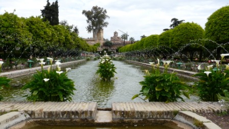
A positive note is that on Wednesdays the entry into some of the attractions is free. The Alcazar gardens were at their best and addressed all of the senses at once. Beautiful to look at, the scent of the orange blossom, roses, stocks and lillies, the sound of the birds and the water flowing, the feel of the spring sunshine contrasted by the cooling interior of the buildings create a great feeling of calm.
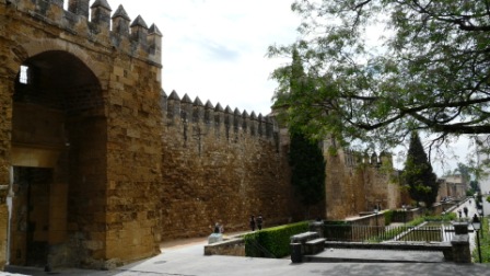
We walked around the walls and stopped at the Old Inn at Potro for a beer. The area was classified as a World heritage site in 1994 and there is still a lot of money being spent improving the infrastructure of the whole city.
The day after was spent relaxing, catching up with our blog and web site.
We had booked a meal at the camp site restaurant and ate traditional paella, which was delicious. As there was too much for the two of us they boxed up the leftovers for our lunch the following day.
Overnight it rained a lot and was still raining when we awoke. It looked set to stay that way for a while so we decided not to move and booked in for another night.
We chatted with a British couple, Alistair and his wife, and hitched a lift from them into Cordoba for a second look around.
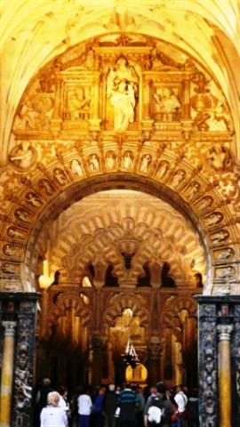
This time, we decided to pay our 8 euros apiece and visit the Mesquita.
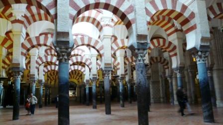
It was worth it and we were pleased that we had not missed the opportunity.
What made it special was the blend of the Muslim and Christian cultures and architecture.
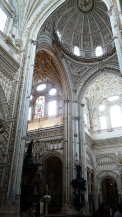
The contrast between the simplicity of one and the flamboyance of the other is remarkable.
Having done Cordoba we caught the bus back to the camp site and cooked up the leftover paella from the night before.
Andalucia - Day 18 - La Guijarossa to Baena
- Distance 66km
- Max Elev 435m
Ride Description
We had to leave today because the campsite lady was fed up of printing bills for us. We got packed up before breakfast so had an early start. It was a perfect morning for cycling, cloudy but warm and our route took us along a low ridge through olives with colourful verges full of a multitude of different wild flowers.
About midday we arrived at Fernan Nunez after a hot climb and were surprised to see a shop at the side of the road with a huge banner with its website address "www.lossecretosdelulu.es' This seemed very liberal for a small Spanish town. On the opposite side of the road was a cafe so we stopped for coffee.
While Steve was paying the bill a Spanish guy came out of the bar to chat to Karen. He spoke good English and explained that he had been to London to study his art, he was a jewellery designer. He went on to say that the shop that we had seen over the road belonged to his wife who had set up a business, on similar lines to 'Ann Summers' in Britain, selling through internet and hen-parties. We made to leave but he insisted we come over the road to see the shop. We were hesitant but curious. He presented us with a carrier bag as a 'free gift'. The (very attractive, young) shop assistant then gave us a graphic set of instructions on how to use it. It's amazing how universal the language of sex is.
With our new toy safely stored and hidden in a pannier we set off, eager to reach our overnight accommodation. We thought we'd better not be on a campsite! It wasn't far to Castro del Rio where we hoped to stay. However we were told by the locals in the bar that the only accommodation was a rural hostel at the bottom of the town. When we arrived there, it was rooms above a busy local bar and as it was Saturday it was likely to be noisy until at least 1am. We decided to carry on to the next nearest town, Baena.
More by chance than planning we found a lovely quiet road which followed the river valley.
It was very hot and sunny and the Spanish were all enjoying the afternoon with family picnics in the shade. We had a long hot climb out of the valley and across to Baena where we fell into the first bar we came to and downed about 1 litre of water each. Steve asked the bar-man where the oficina de tourismo was and received sharp intakes of breath. It was closed. He then asked if there was a hotel, pension etc in the town. Within minutes the three lads had decided that we should stay at the albergue. After a quick discussion in Spanish, beyond Steve's meager abilities, they concocted a plan and before we knew what was going on two of them had set off in their car telling us to wait. A few minutes later they returned in one car and a pick-up and proceeded to manhandle our bikes, panniers and all onto the back of the pickup. They wouldn't quite fit so one of the lads removed his trouser belt and lashed the wheel of one bike to the truck. We leaped in the back seat and he set off, followed by his mate in his car, up the steep and narrow village streets, scarcely wide enough for a vehicle, up and up, round and round we went, with Steve clinging onto his precious bike for all he was worth, through the back window of the pickup.
Finally we arrived, stressed and bothered outside the albergue at the top of the town. They unloaded the bikes, shook hands and were off with hardly time to thank them properly. The kindness of people continues to astound us.
We checked in to a lovely, newly refurbished albergue for 35 euros including breakfast. After a refreshing shower the crisp white sheets and the excitement of our free gift beckoned.
What a day!!!!
In the warm evening sunshine we walked around the town...
Everyone was out enjoying the warm night and they were also so friendly towards us, (perhaps they knew what we had in our panniers!)
We had a great meal and retired for a good nights sleep. Of course we had not counted on it being a warm Saturday, fiesta night and the revelling went on until 1-00am, but we were happy.
Andalucia - Day 19 - Baena to Andujar
- Distance 62km
- Max Elev 499m
Andalucia - Baena to Andujar Ride Profile
Ride Description
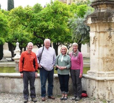
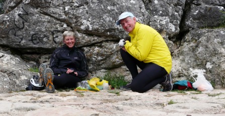
We ate a lovely breakfast of local ham, bread, orange juice and coffee with a British couple Dick and Liz Creans, from Bristol.
They were doing the Califate walking route, one of the many pilgrims routes through Spain from Granada to Cordoba. We swapped stories and after the customary photograph, we left in one direction as they left in another.
We both realized that we seemed to have reached a point today whereby we were looking forward to what the day would hold rather than fretting about how we would cope with it. The ride today would be another long haul, but it was cool and overcast, perfect for cycling.
The ride was through rolling hills of more olive groves, barley and other cereal crops.
We stopped for our usual morning coffee at Fuenteduena and lunch in Porcena. Being Sunday all of the locals were out for their after church constitution, dressed to the nines. We even spotted a family celebrating their young daughter's first communion. She was dressed in a lovely white, frilly confirmation dress. After esalade mixte, patatas frites and beer we continued on our journey. Many people were out for a drive in their cars, and we got lots of encouraging beeps on the horn. There were also lots of Spanish out for a picnic. They will stop anywhere, on a roundabout, under a road sign, it really didn't matter and every time we received shouts of encouragement as we cycled along.
Finally our destinaion town, Andujar, came into view with the beautiful Sierra Morena behind, marking the border between Andalucia and Castillo la Mancha. We enjoyed the final long downhill in the warm afternoon sunshine, all the way to the town.
Finding accommodation however was a more difficult task. The camp site that we had planned to stay turned out to be 14 km out of the town up in the mountains and the road was closed for the fiesta. We cycled around the town, which was almost deserted (typical at this time of day). The oficina de tourismo was closed because of the fiesta and we had to ask several locals for directions to accommodation. A combination of poor Spanish on our part and poor local knowledge on theirs led to a fruitless search for a pension. Finally we returned to town and the only hotel. Being fiesta their rooms were 81 euros each. The receptionist took pity on us and let us have a room at their normal rate of 54 euros. Good job we are absolutely loaded with money.
Still, it was very welcome and a warm shower and a couple of beers made us feel a lot better.
Andalucia - Day 20 - Andujar to Mengibar
- Distance 27km
- Max Elevation 368m
Andalucia - Andujar to Mengibar Ride Profile
Ride Description
For the first time since we set off on our Andalucia tour, we woke to clear blue skies. We were up early and had a quick breakfast in the hotel.
We had planned to get to Linares and Steve had seen a road along the valley between the railway and the river which looked quiet and flat. And indeed it was a lovely ride, with no traffic and a relief not to be cycling through endless olive groves for the first time in 15 days. The road gradually deteriorated to a rough track, but the map showed a bridge over the railway onto a lane that would connect up with a tarmac road. However the bridge was no more than a concrete construction designed to take a road at some point in the future, but never finished and there was no way across by that route. We retraced our tracks to a rough level crossing, and onto another unmade, track through a ford. It then became a very rough, loose stone track up a steep hill and back into olive groves. It was getting very hot without a cloud in the sky but at least the track was now downhill. Finally we connected to the planned tarmac road and rode into Villanueve de Reina where we shopped for some lunch provisions.
Shortly out of town we stopped for leftover pizza saved from the night before, red wine, tea and biscuits. The heat reduced our appetite and we were quickly on our way again climbing a long and dragging hill into Mengibar (which we thought sounded like some form of disease). We stopped at the first bar and decided that it was too hot (28 deg+) to cycle much further, so asked about accommodation. We cycled up to the centre of the village on the hill top, but the hotel turned out to be a four star 'paradore' type hotel. Without asking we deemed it to be too expensive.
We dropped down the hill and found a modern three star hotel which again we thought would be too expensive, eventually finding an unrated, seedy looking hostal. We booked a room at 40 euros!. It had no windows, but did have an en-suite shower room of sorts. Karen was worried about how we would get out if there was a fire. We sorted out an escape route through a spare, open room on the other side of the corridor, but by bedtime it was occupied by some noisy workers with weak bladders who kept going to the toilet along the corridor all night.
We looked around the town and enquired about the prices at the other hotels, which were euros59 and 56 respectively. We would have gladly paid the extra to get a decent place to stay.
Andalucia - Day 21 - Mengibar to Banos de la Encina
- Distance 25km
- Max Elevation 444m
Andalucia - Mengibar to Banos de la Encina Ride Profile
Ride Description
To avoid the problems with the heat that we had experienced the day before, we decided to get up early. After a quick breakfast in a cafe over the road from the hostal we were away by 8-10am riding along the old main road to Bailen. In the cool of the morning we made good progress, despite it being a long gradual up hill. We arrived in Bailen in a non-descript square and asked for the historic center, only to be told we were in it. It was that remarkable. We bought lunch and headed out on a quite easy road towards our destination.
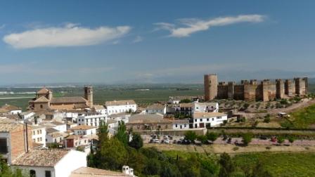
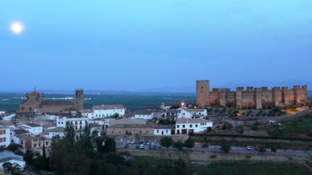
As we came over the hill we got great views of Banos de la Encina with its impressive castle and churches
Our plan was to visit the castle and then continue to Linares for the night. However the castle was closed as a TV crew were doing some filming. We were told that we could stay in the town and visit it the next morning. So why not?
We checked into the Banos Hotel which had even better views of the castle.
We met a German couple, Manfred and Hetty Stolz who were cycling around the area on mountain bikes, staying in accommodation. They had just suffered a horrible ride through deep mud the day before and needed a nice place to stay.
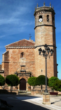
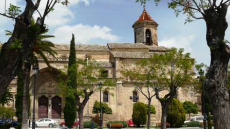
During the afternoon, we looked around the impressive baroque church, but unfortunately couldn't get to see the larger church in the town except from the outside, (shown here).
We met a German couple, Manfred and Hetty Stolz who were cycling around the area on mountain bikes, staying in accommodation. They had just suffered a horrible ride through deep mud the day before and needed a nice place to stay.
During the afternoon, we looked around the impressive baroque church, but unfortunately couldn't get to see the larger church in the town except from the outside, (shown here).
There wasn't a breath of wind and many of the locals were out walking, running, cycling, horse-riding or picnicking by the water.
We met Manfred and Hetty for dinner and took in the view of the castle as the sun set behind us.
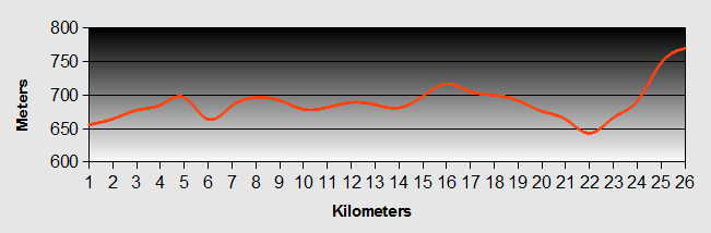
Andalucia - Day 22 - Banos de la Encina to Baeza
- Distance 39km
- Max Elevation 775m
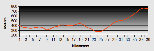
Andalucia - Banos de la Encina to Baeza Ride Profile
Ride Description
Today was to be a difficult one. Our goal was to reach the camp site at Ubeda.
First we had to see the inside of the castle, the main reason we had stayed overnight. We went with Hetty,( Manfred had gone out for a bike ride on his own) but the only time available was at 11-00am. Being Spain, the tour didn't start till 11-30am.
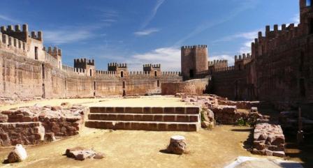
It was 12-30 before we left and it was already very hot. We had just broken our new rule about avoiding riding in the heat of the middle of the day.
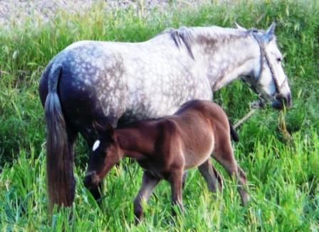
However, the route looked to be straight forward without too much climbing. The first part was across a flat plain through olive groves as far as the motorway. From there the countryside changed dramatically. The area was less cultivated, with many natural extensive meadows and large holme oak trees.
This was fighting bull breeding country and we spotted several of these magnificent beasts sheltering from the baking sun under the trees.
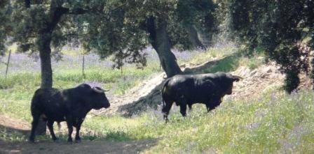
The area also has a history of mining copper, lead and silver and we could see the remains of this industrial history as we cycled along.
Linares is a large and busy town. As we cycled in the thermometer said 32 degrees. We didn't take time to look around and after a tapas lunch headed out towards Ubeda, joining up with the very busy main road just outside town. Foolishly we missed an opportunity to take on more carbohydrate and top up our water bottles. We were not happy about the long ride along the busy main road to Ubeda. From the top of the hill we surveyed the route. There was a long downhill and then in the distance a modern road climbing through miles of olive groves with no shade. Steve decided he wasn't going that way. Instead we turned onto the road to Baeza. It was only 9 kilometers, but after a short distance we realized that we were actually on the road that we had seen from the top of the hill, it was all up on a modern sweeping road that reflected the heat and gave no protection from the baking sun.
We were both suffering the effects, but Karen more so. Our water was running very low and we had to stop several times to shelter below the olive trees to cool down. After several discouraging false summits we finally reached the village of Isobar, the main street of which was being resurfaced so was rough and dusty.
We fell into the first bar we could find. We drank a liter of water each followed by two beers (Sin alcohol) and two lots of tapas. It was clear by this time that there was no way that we could visit Beaza and then continue to Ubeda and an overnighter in Beaza was on the cards.
As we set off again to complete the climb the road gang were just starting to lay the first section of new tarmac at the roundabout. We had to wait at the stop sign (a Spanish guy holding a little sign that said STOP). There was just one car in front of us. When the sign changed we were supposed to go clockwise around the wrong side of the roundabout but the guy in the car did not understand that and drove anticlockwise, straight into the deep, hot, soft tarmac. The road workers were not at all pleased, we think they probably just rode over him with the steamroller. We also couldn't resist just getting a short tyre track in the edge of the tarmac.
The ride to Beaza was worth it.
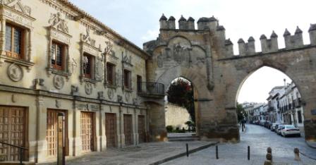
The townsfolk have retained a lot of the lovely historical buildings and and it seeps history from every street.
All of the ancient buildings are in a beautiful honey coloured stone and have extensive stone carved decorations.
We checked into the three star TDH hotel for only 50 euros per night.
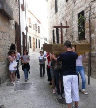
We took a relaxing stroll around the town where we bumped into a group of young teenagers earnestly rehearsing for the fiesta parade which was to take place that weekend.
After a calorie filled evening meal we fell into bed, absolutely shattered.
Andalucia - Day 23 - Baeza to Ubeda
- Distance 19km
- Max Elevation 772m
Andalucia - Day 23 - Baeza to Ubeda Ride Profile
Ride Description
After 5 days of continuous riding and the killing high temperatures over the last few days, we decided that we needed a few days of relaxation. So today we had an easy ride to Ubeda, sought out tourist information, shopped and headed straight for a camp site 1km outside the town, planning to stay for a couple of days. It was also coming up to the May Day holiday so we could expect a lot of Spanish holiday makers everywhere.
The camp site was typically Spanish. All hard standings with gravel bases, but at least it was shaded. There were no other tents in the camping area. The pool was closed, but the bar was open and had internet access. It seemed quiet enough when we arrived. We spent the afternoon relaxing by the pool even though we couldn't swim.
The first night we were disturbed by the barking of many dogs in the properties around the site, so we didn't get much sleep.
The following day we rode into town, locked up the bikes and did some exploring.
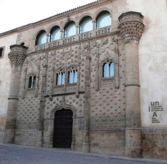
The old town is very separate from the more commercialised modern areas. There is little traffic in the narrow streets and the buildings are largely built from a hard, reddish sandstone. A lot of restoration has been completed and more is being carried out. It is well worth a visit to see the many old churches, ayuntiamento and palaces.
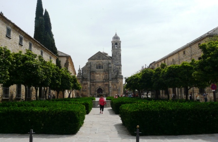
The most memorable visit for us was to the convent and church of St Juan the healer which has now been opened as a museum as well. The museum houses a number of eye catching, modern Christian paintings which made a refreshing change from the classical paintings seen in most other churches.
That night the dogs were quieter, but there was an all night hen party at a house close to the site. The girls were singing and didn't give up until the cock crowed at around 6am. So again we didn't sleep well. The day after we had enough of sightseeing and instead decided to pack a picnic lunch and crazy as it may sound, we went for a bike ride to the Guadalquivir river some 20km away.
This night, the dogs didn't bark, the girls didn't party, but in the caravan next to our pitch a long lost mate turned up with his guitar and they spent the whole night singing! No sleep again! By this time we had had enough and we had to move on.
Andalucia - Day 24 - Ubeda to Cazorla
- Distance 45km
- Max Elevation 804m
Andalucia - Ubeda to Cazorla Ride Profile
Ride Description
We tried to get an early start as the sky was clear and it would get hot. The first 10km was along the main road, but as it was Sunday it wasn't too busy. We turned off towards Cazorla and had a lovely long descent to Peal de Becerro where of course there was an inviting bar with tables in the sunshine serving lunch. As we enjoyed our meal 2 Belgian women, also traveling on bikes arrived in town. Steve was impressed with their riding outfit of skimpy t-shirts and very short skirts. They joined us and told us about their many bike journeys in different parts of the world. They were on the last few days of their trip before returning home.
After an enjoyable lunch we set off again to complete our ride to Cazorla, which was mostly up hill on another of those modern boring roads.
We finally arrived at the camp site just outside the town. The site is run by a Dutch family and is quite lovely. All the tent pitches are fully grassed with plenty of shady trees and there are sets of tables and chairs for the campers to use.
It was extremely quiet with birdsong being the most intrusive noise. A 1.5km walk along a quiet lane took you into the village. That evening we sat in the sunshine in the plaza, watching the sunset, and enjoying a lovely meal, followed by the best night's sleep that we had experienced in our tent for a long time.
Cazorla is a beautiful town with good restaurants and bars.
The next day was an opportunity to do some walking, but first we rode to the local market in the town and visited tourist information. We asked them about the apparent free camping areas in the National park that we had read about in the Rough Guide. They said that we needed to get a permit from Andalusian National Park offices, just up the road. Enquiring there, the initial reaction was a flat "No", but we persisted and the receptionist called a girl from the relevant department. She came down to talk with us and in a combination of Spanish, French and English, we finally understood that the free camping zones can only be used by groups with a permit issued by that office. However, if we only wanted to stay one night it was no problem, as long as we pitched late and left early. So, not quite what the Rough Guide inferred, but at least we could use the zones if necessary.
After lunch we climbed the Sierra at the back of the camp site to the Monasterio de Monte Sion and the Castillo de Cinco Esquinas.
The pastures of the mountainside were full of flowers, most of which we had seen in the valleys, but all in miniature, alpine versions.
We had lovely views back towards the town.
When we got back to the tent we found that in our absence we had been raided by an unidentified animal. It had ripped to shreds our rubbish bag, suspended from the roof to deter such attacks, eaten the remains of a Camembert cheese and nibbled the corners off about 50% of our tea bag supply. What sort of animal has this kind of palate? We came to the conclusion it must be a thirsty French ferret.
As we got ready for bed the temperature had fallen noticeably and we had to zip our sleeping bags right up for the first time for ages.
Andalucia - Day 25 - Cazorla to Parador El Adelantado
- Distance 24km
- Max Elevation 1337m
Andalucia - Cazorla to Parador El Adelantado Ride Profile
Ride Description
Overnight the temperature plummeted to about 4C. We got up and started to freeze as we decamped. Once we were packed we got onto the bikes with frozen hands and feet and rode as fast as we could into the village for coffee to thaw us. Slightly warmed we set off for the long but steady and enjoyable climb up to Puerto de las Palomas. At least climbing kept us warm.
We stopped for a brew half way up, huddling behind a rocky outcrop to keep out of the wind, with the ever waiting vultures circling overhead.
In contrast to the usual formula, the downhill on the other side was torture as every bit of us froze. Halfway down, we came to a road junction with a signpost to the Parador to the right. Steve said "Why don't we stay there tonight?" Karen said "Don't be stupid we can't afford that". "Well that's where you're wrong" was the reply, "Simon and Ben have paid for us to stay there for your birthday". Wow! But the problem was the booking was made for the next week and we needed to make sure we could change it. Being deep in the valley, we couldn't get any mobile reception, so dejectedly we set off down the hill towards the next town. After a couple of kilometers, we stopped and tried again. This time we had success. Yes, they had rooms and yes we could change the dates. Having to cycle an extra 2km back up hill didn't seem quite such a hardship once we knew that we had two nights in the Parador ahead of us. After about another 7km Steve hit a sugar low (bonked as we say in the cycling fraternity) and we had to stop for some more "biting on". It was then on and up the final hill. Lovely pine covered road, but very steep and we were in 1st gear for about 4km.
At last the hotel hove into view. We were set for two days of relaxation and pampering! (with central heating)
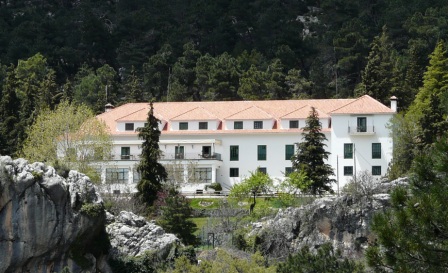
As we checked into our room a few snow flurries fell. It was that cold! However, the Parador heating was on full and it was so warm and cosy, with crisp white, Egyptian cotton sheets, comfortable mattresses and a nice hot bath.
After relaxing for the rest of the afternoon, we went to dinner in the restaurant and sat with an English couple, Rex and Anne from Peterborough. They live half their time in the UK and half in Spain. We had a really entertaining evening and chatted with them until almost midnight.
The next morning when we went for breakfast (about 10-00am) it was only 5 degrees. We met up again with Rex and Anne and again chatted until it was time for them to leave. Graciously, they proposed that we could stay at their house in Spain or the UK any time. How fantastic that we continue to meet such lovely people!
These two days were Karen's time and she wanted to really take it easy. We went for a short walk up the mountain through pine forests and closely grazed grassland. The flowers were all of the alpine variety. We stopped to take photos at a strategic point. Although we didn't actually see any wild boar, we did see the result of their foraging and also sampled their flesh that night in the restaurant.

Then it was back to the hotel for lunch.
Andalucia - Day 26 - Parador El Adelantado to Coto Rios
- Distance 30km
- Max Elevation 1337m
Andalucia - Parador El Adelantado to Coto Rios Ride Profile
Ride Description
We had a lazy start, getting to breakfast at about 10-00. The temperature had risen to 9 degrees and the wind had swung round to a southerly. Today's ride was a complete contrast to the ride from Cazorla. It was warmer and it was 95% downhill through stunning scenery along the main road through the park. We briefly chatted with a Dutch couple also riding the same road and later stopped at the Torre De Vinagre visitor center which gives a good interactive overview of the park, animals and flora of the region. The most stunning exhibit is a pair of deer antlers locked together as they had fought and died. It shows a picture of them as they were found and the antlers and skulls have been preserved in this locked state.
A few kilometers further on we arrived at Coto Rios. We rode past the first camp site and decided to stay at the Camping Rural Llanos De Arance for a couple of nights. We wanted to walk the Rio Borosa gorge the following day.
The site was pretty typical Spanish style, large, with cabins and fixed caravan pitches. The rest was all hard standings. There was a large school party there comprising about 40 kids + teachers. It was difficult to determine who the teachers were, they looked so young. We pitched the tent as far away from them as possible. That night was their last and the teachers had laid on some special entertainment, which seemed to include pre-recorded sound effects played very loud and resulted in most of the girls screaming a lot. However, come midnight, as per site rules, they promptly shut up and we didn't hear another thing from them. We slept peacefully apart from the strange phenomenon of song birds singing throughout the night. In the morning we cycled about 8km to the start of the walk up the Rio Borosa gorge. Along the way we startled a family of wild boar, which fled up into the woods.
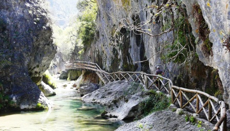
The Rio Borosa track winds its way gently up the pine clad valley following the crystal clear river which is teaming with fish. At each turn we were greeted by a new stunning vista. We crossed the river several times and at one point the path follows a wooden walkway constructed along the side of the narrow gorge.
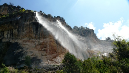
The steepness increases slightly up to the hydroelectric generating station, at which point the track turns to a footpath. The real climbing starts here and as we struggled up the steep and rocky path we were rewarded by deep aquamarine pools and stunning waterfalls.
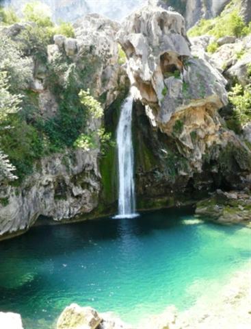
This amazing landscape has been formed millions of years earlier through violent upheaval. We saw wonderful rock formations around every corner. This walk certainly lived up to its reputation as one of the best in Spain.
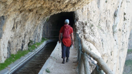
The steep climbing stopped when we reached the man made open channel waterway that takes water to the generating station several hundred feet below. It runs through tunnels cut into the rock face with a narrow footway by the side. Emerging at the other end is like coming out into a lost world.
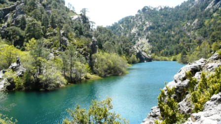
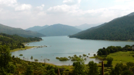
The final part is fairly gentle finishing at the small, but beautiful reservoir. Following our picnic lunch we started our descent the same way that we had come. Karen was lucky enough to come intimately close to a fox. She couldn't quite get the camera ready quickly enough and after giving her a chance he slowly ambled into the undergrowth.
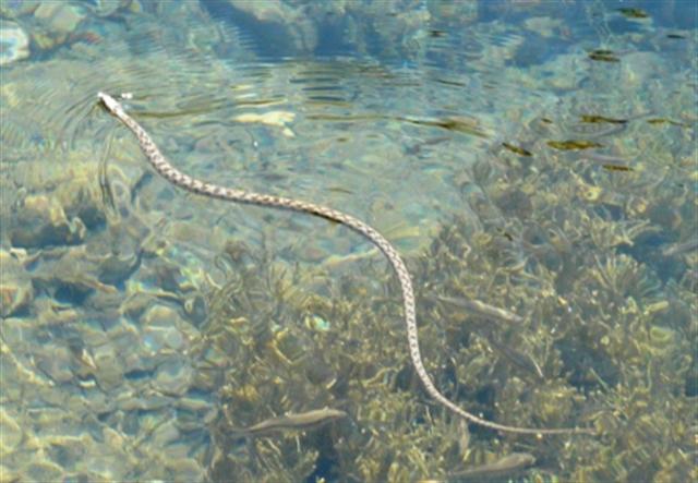
We also saw a snake swimming in the water and lot of birds of prey, which we determined were some form of eagle.
Half way back to the generating station we were surprised by a couple of falls of water streaming over the edge of the cliff above the path. The water was turned to spray by the wind as it fell soaking everything below. The strange thing was that when we had come up the path it wasn't flowing. We guessed it must have been something to do with the generating station water way.
The way back seemed much longer and after 7 hours we were glad to get back to find our bikes still securely locked to the tree where we had left them.
Andalucia - Day 27 - Coto Rios to Montillana
- Distance 26km
- Max Elevation 772m
Andalucia - Coto Rios to Montillana Ride Profile
Ride Description
The pigs came to visit us last night. We were pleased that there was a fence between us and them. They snorted around a bit and provided a source of entertainment for other campers to come and have a look. We couldn't be bothered to drag ourselves out of our beds to see them.
It was a bright and sunny day and we cycled along the side of the river, broadening out when we reached the reservoir. The road was easy, up and down with great views and hardly any traffic, even though it was Saturday. It is a popular circuit for road cyclists and we were passed by a couple of packs at speed. We stopped and chatted with a couple who told us they were doing the circular ride of the Sierra, 156km in 6 hours.
The water was aquamarine in colour, reflecting the mountains and forests. The sun was warm and there was a light breeze. We saw another fox, just standing at the side of the road, deer on the hills, and countless wild flowers and butterflies. We were soon cycling into Tranco, where the dam is. A number of hotels and restaurants had grown up here and we stopped for a coffee and "lomo" sandwich. The dam was built in 1936, using the labour of prisoners of the Civil War.
The road then started to climb up from the side of the reservoir and after about 3km we arrived at a lovely camp site "Camping Rural Montillana". There were only a few people there. The pitches were grassed and shaded. It was an ideal and peaceful site. In the evening we took a walk down by the lake. There was an old Cortijo there, a real temptation as a conversion.
The Sierra really lives up to its reputation for unspoiled beauty, peace and quiet, flora and fauna. It is a lovely place. However, it was apparent to us by the number of hotels, accommodations, camp sites, picnic spots, etc that in the high season the place would be heaving. So if you fancy visiting the park we suggest you make it in May or June and preferably during the week. One thing that has amazed us is the numbers of people employed by the 'Junta de Andalucia' in the maintenance and organization of the park. The large majority of vehicles on the road are government ones and at every turn there are men clearing the drains, strimming the undergrowth and maintaining the buildings. While I am sitting writing this there are seven of them sat at the bar having their lunch (today is Sunday).
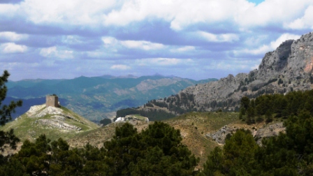
Today, we had planned to ride up to the village of Hornos de Segura (without weight), which is situated high on a rocky outcrop, overlooking the reservoir.
Unfortunately, after getting up and ready to go, it started to rain. The weather closed in and it was obvious that we were not going anywhere. Instead, we spent our time in the camp bar eating, drinking and writing the blog.
Andalucia - Day 28 - Montillana to Garrotegordo
- Distance 34km
- Max Elevation 1431m
Andalucia - Montillana to Garrotegordo Ride Profile
Ride Description
Having not managed to get to Hornos yesterday, we changed our route and decided to ride that way today. First though we had to get cash, petrol and provisions. We rode to the top of the reservoir and up the hill to Cortijos Nuevos and had first breakfast in a small bar.
Shopping completed we back tracked and then up the hill to Hornos de Segura to admire the views down the reservoir. Unfortunately the castle is still being refurbished and hence there was the mandatory crane rising from the center of the village.
After a quick look around we carried on climbing up the valley to La Cumbre ridge, reaching a height of about 1550 meters. It was quite cold, but we sat and had lunch before we descended the other side reaching the bar at Rio Madera. We stumbled in and warmed ourselves with a coffee and brandy.
We were now into much more remote country. There was almost zero traffic as we rode through the valley surrounded by pine and deciduous forest. The verges were full of violets and primroses which reminded us of our old home in Thornton Dale.
We reached the Garrotegordo Camp Site, near to nowhere. It seemed deserted and there were no other campers. Eventually the lady owner came out and we went into the cold, dark bar to sign up. The heavens opened and it started to pour with rain, so we had to wait it out and try to make conversation. She spoke no English. She then informed us that there was a problem with the hot water in the showers, but that we could use her shower when we were ready.
Tent pitched we returned and she said that the boiler was now working and the water temperature was 40 degrees C. So, we showered. It was bloody cold, damp, draughty and really didn't satisfy. There was a covered barbeque area so we carried all of our cooking stuff there and cooked our dinner. It was still raining. We eventually retired to bed early and it rained most of the night.
Andalucia - Day 29 - Garrotegordo to Santiago de la Espada
- Distance 31km
- Max Elevation 1578m
Andalucia - Garrotegordo to Santiago de la Espada Ride Profile
Ride Description
By morning it had stopped raining, but the tent was wet and we had nothing for breakfast except milky coffee, yoghurt and biscuits. We packed quickly and set off. We knew that today would be long and hard, but the first part was mostly downhill.
It was a day of gorgeous gorges. The ride down was along the Rio Segura with massive towering cliffs of red sandstone, streaked and etched by water rivulets which made it look like they had their own natural graffiti. We were desperate for something to eat and we turned off our main route to the village of La Toba. This meant an unprecedented ride up a hill for no other reason other than to eat! On the way up we passed the old village wash house where one of the residents was doing her washing in the time worn, traditional way. Breakfast was coffee and tostadas (no jam, just margarine straight out of the tub), served reluctantly by the lady owner who seemed upset that we had disturbed her floor mopping.
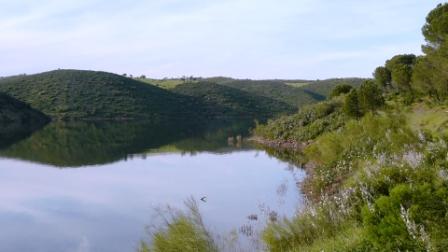
Slightly sustained, we rode on along the side of the Embalse de Anchuricas reservoir, which was deep turquoise in colour.
We were still looking for more sustenance and stopped again in bar at the side of the road. There was one customer there, but nobody serving. After shuffling our feet for a while, the customer went through the back and returned, asked what we wanted and served us our beers. We asked for tapas. He brought a plate of stale nuts. After 10 minutes, the landlady came through, looking like she had just got out of bed and served us a ham and cheese bocadillo (sandwich). Not the fulfilling food we needed, but it was about all we were going to get.
The ride went on further down the valley all the time through stunning, rocky scenery and reached our lowest point at the Los Juntas hydroelectric power station.
Here we turned up the Zumeta gorge. This was narrower than the one that we had come down and was even more rugged. There were huge columns like giant rock fingers, caves and wondrous cliffs that our mountaineering friends would have loved to climb.
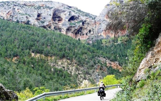
The one thing that was missing was any from of cafe or bar that was open. We stopped for snapping on and ate the last of our carried reserves i.e. cheese, biscuits, chocolate and peanuts and of course a cup of tea. Just then it started to rain and we had 22km of all uphill riding ahead of us. The rain stopped us taking as many photos as we would have liked, but the gorge was so impressive that we didn't care about
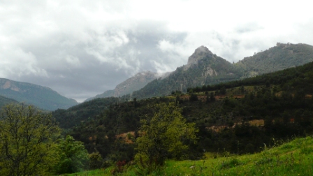
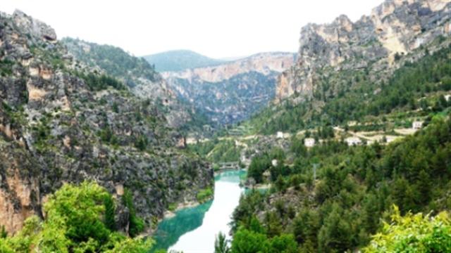
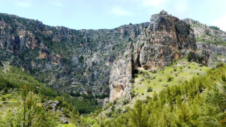
The climb went up and up, the scenery changing as we ascended. As we go higher it got colder and we arrived in Santiago de la Espada at 1400meters.
There was only one hotel in the town and it happened to have the only restaurant as well. So we had to pay a little more than normal, but the food was good, it had central heating and it was nice to be warm and dry. When we complained about the cold in the restaurant they lit the log fire just for us.
That night we were toasty warm and we slept well.
Andalucia - Day 30 - Santiago de la Espada to Huescar
- Distance 50km
- Max Elevation 1764m
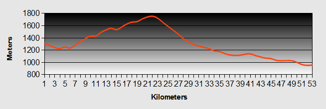
Ride Description
We awoke to rain again and it was still very cold. The route today would take us up to 1800 meters and there would be no villages or bars along the way, so we bought provisions before we left. We didn't want a repeat of yesterday.
By the time we were ready to leave the rain had stopped and the sun was sort of shining, but it was still no warmer.
The journey took us across the high fertile plain at the top of the gorge before we started to climb the Sierra de Sagre. As we ascended we spotted the cave dwellings that have existed for hundreds of years, similar to Guadix.
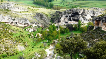
We rode up several hairpins through pine and holm oak, sheltering whenever it rained (and sometimes sleeted) and taking the opportunity to brew up and eat.
Despite the cold and on off rain, it was a lovely ride and after a couple of hours climbing we reached our highest point, 1800 meters, with stunning views over the Sierra de Seca...
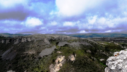
...and of the dominant mountain, Sagra 2381 meters and still holding some snow. Unfortunately it didn't favour us with a full view as the cloud level at about 2000 meters stubbornly refused to lift.
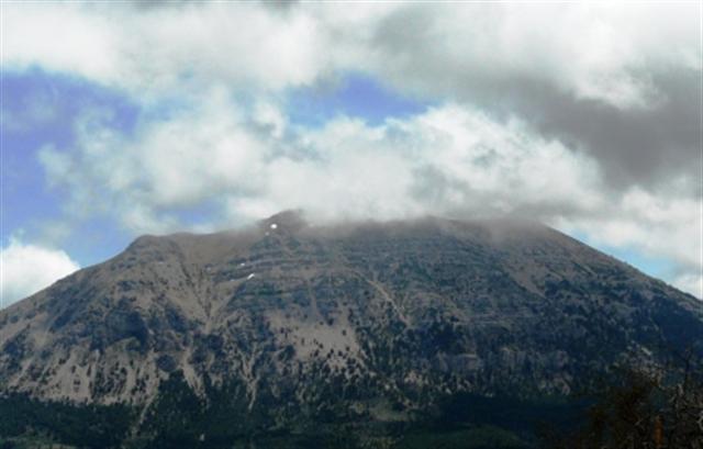
We had lunch and prepared for the long downhill by putting on all of our warm gear and full waterproofs.
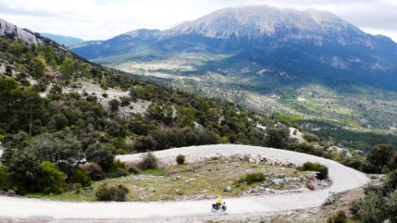
It was a good job we did. It was very cold and we were so thankful for our warm clothing. Our thanks increased when the heavens opened again and we were hurtling down through hair pin bends and driving rain. At the bottom of the hair pins we sheltered in an old barn until the rain slowed.
The rest of ride was gently downhill through the Bravatas valley and by the time we had reached the turn off to the Embalse de San Clemente, the rain had stopped and the sun was much more warming. We stopped in the warm sunshine and watched a flock of beautiful bee-eaters swooping and diving, the sun shining through their feathers making appear to be iridescent gold and blue.
We decided against going on to Castril where there was a camp site and instead headed into Huescar to find a hotel. On the way Karen had to rescue an injured bird from the road which was in danger of being squashed by the traffic. The road there was one of those wonderful gentle downhills that makes you feel as if you are flying with no effort.
We found a hostal in the suburbs which was reasonably priced. That evening we again had problems finding anywhere to eat in town. They just don't seem to do eating out round here. Enentually we asked in a bar and were directed to the hotel. The food was not cheap but it was plentiful and very good quality and we asked the waitress to pack up the leftovers for the next day's picnic.
Andalucia - Day 31 - Huescar to Baza
- Distance 45km
- Max Elevation 962m
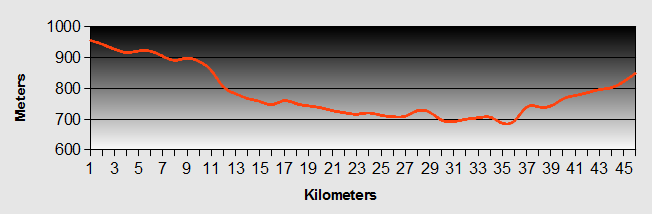
Andalucia - Huescar to Baza Ride Profile
Ride Description
We had got it in our heads today that we had an easy, short ride to Baza, always a mistake because it never is easy! The ride took us across the Alteplano (high plain) de Granada which in fact is not a plain at all but made up of small, sandy steep sided hills with grass tufts, and wadi like valleys. The road was yet again a modern straightened one, running through cuttings.
We stopped for coffee in Castillejar in a bar with a Harley Davidson engine for a beer pump and an old Moto Guzzi moped in mint condition in the bar, (it looked a bit like our bikes only with an engine and it was red).
This area has many soft pale rocky outcrops which have been hollowed out to make homes for centuries.
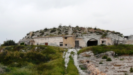
A lot of them have been renovated and are rented out as holiday accommodation.
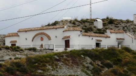
Today at least the sun was shining and we had lunch on a section of the old road and took the opportunity to spread out all our camping gear in the sun to dry it while we ate.
The next town we passed through was Benamaurel which had an interesting looking old Arab quarter on the top of the hill. We decided to ride up and look. As we turned off the main road, an old Spanish gentlemen beckoned to us, he wanted to show us something. Not quite knowing what to expect we followed him and there was a litter of 8, 5 day old kittens abandoned at the side of the road. He seemed to expect that we would take them with us but we decided that fostering kittens on a bike was too much. We continued up the very steep hill but were disappointed as all the effort was hardly worth it.
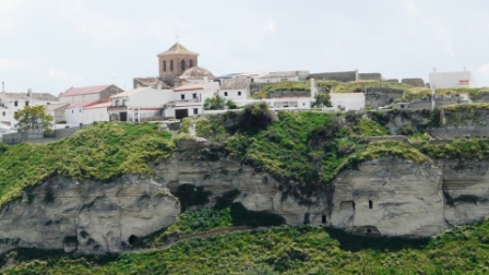
We felt quite fired although the ride had not been bad. The straight road had a lot of quite fast traffic and we were relieved to arrive in Baza. We fell into the first bar we saw and had a beer to cheer us up before setting off to find Tourist Information. She suggested a hostal quite close to the bar that we had just left. We rode down and were put of a bit by the outward appearance. Inside however was a pleasant, newly re-decorated and furnished hostal with nice bedding and towels.
Again that evening we struggled to find anywhere to eat. Our appetite for Spanish cuisine was getting a little jaded and we longed for a good Indian or Chinese. Eventually we followed the signs to a small Bodega down a side street, which exuded good quality wines and local produce but not food. We could tell immediately that the owner was a conniseur and would know where we could find a good restaurant. He recommended a place which just so happened to be next door to where we were staying. We were not disappointed and had a wonderful meal.
Andalucia - Day 32 - Baza to Olula del Rio
- Distance 52km
- Max Elevation 986m
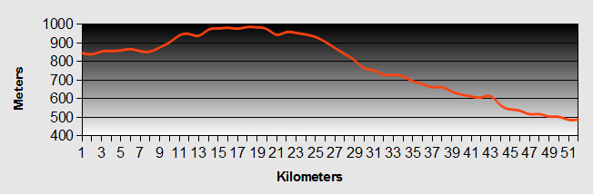
Ride Description
Today,s ride was following the A334 across to Seron and then on through the Almanzora valley. We were expecting the road to be busy and fast, but it was new smooth tarmac with a wide hard shoulder and not as much traffic as we expected. There were no major climbs and a lot of downhill but the weather was cold and we had to stop for coffee to thaw out. As we came out of the cafe it started to rain, but we set off anyway. After only a few minutes the rain poured and then turned to hail. We dived into a bus shelter and waited for it to stop.
Thereafter the ride was mostly downhill. The rain held off, but it was still very cold. We passed through a forest of wind turbines, only meters from the road and towering over a few nearby houses. The blades made loud whooshing noises as they turned through the air.
As we were bypassing Seron we spotted an old railway track that had been made into a via verde, but we couldn't tell how far it went or how to get onto it, so we stayed on the road.
Again the weather turned colder and windy. We stopped for shelter again for food and warmth.
By now we had reached Tijola and we tried to find the via verde, but we could only find the old station and no signs of a proper cycle route. So it was back on the road again.
After one more stop for a brew up, we arrived in Olula del Rio, which lies at the junction between the A334 and the main A319 over the Sierra de Los Filabres. It is an important marble and stone mining area and we expected that the town would be quite affluent, but the place felt deprived and run down. For the first time in Spain there were groups of teenagers hanging about in the streets with little to do and a lot of kids cruising around in their motors, playing the inevitable boom boom music. It just didn't feel good. The hostal that we stayed in was equally depressing and for a third night running we struggled to find anywhere decent to eat, opting in the end for a cheap, but passable pizza.
Andalucia - Day 33 - Olula del Rio to Lubrin
- Distance 66km
- Max Elevation 1079m
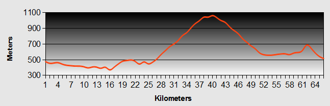
Andalucia - Olula del Rio to Lubrin ride Profile
Ride Description
Karen had made it quite clear that she didn't want to ride up a hill on her birthday. So we started off on the flat, to make her feel better. Riding further along the Almanzora valley we bypassed Cantoria on our way up to Albanchez; a climb that she had expected and then onward to Las Molinas before descending for lunch at La Rambla Aljibe.
Whilst the wind was at our backs down the valley, it changed to a crosswind as we started our ascent into the Filabres hills. At Albanchez, we stopped for a coffee break and then complacently continued on the main road past the village and upwards. It wasn't until we had climbed another 150 meters that Steve realized he had made a fundamental error. On the one day that Karen didn't want hills, he had missed the turn off to Las Molinas and instead of heading to La Rambla Aljibe, we were in fact on our way to Uleila del Campo over a 1070 meter pass!! Oops!
Pursed lips and eerie silence for the next few kilometers, but at least the wind had turned to our backs and it was a steady, gentle climb and it was warm! We were only passed by one motor bike over 26km.
As we neared the Puerto de la Virgen, 1070m, we had one last glance at the Almanzora valley and the distant Sierra de Segura, ...
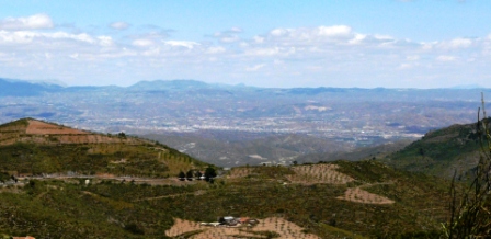
...before we claimed our reward of the long, winding downhill to the plain below Uleila del Campo.
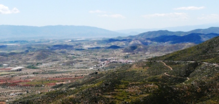
From there it was a dash along the long straight road to El Pinar and the final climb over the hill to Lubrin. We rolled into the Plaza Bar for some good home made tapas and of course an ice cold beer!
We were back!
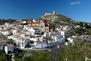
New! Comments
Have your say about what you just read! Leave me a comment in the box below.