Cycling New Zealand's Fiordland
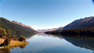
Now we were headed for the spectacular Fiordland and the Southern lakes.
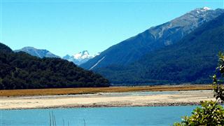
Our ride down New Zealand's West Coast had taken us past beautiful beaches, pristine rain forest and magnificent glaciers only a hundred meters or so above sea level. The section had ended in Haarst, just a few kilometers inland.
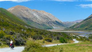
The next section of our route took us up Haarst valley, through the gates of Haarst and up the steep climb to reach Makarora at the head of the southern lakes area. We wound through the lakes calling at Wanaka and the bustling Queenstown.
From there we planned to take the passenger ferry across Lake Wakatipu and then take the cross country route to Te Anau. Here we would rest up for a couple of days before heading north to Milford Sound, before returning by bus to Queenstown.
Schedule
Our ride descriptions give an account of the ride that we completed. As part of the description we also provide links to Wikiloc or Google maps and elevation profiles based on mapping data available through the internet. The ride profiles are smoothed to give what in our opinion is a more beneficial view of the profile. We use paper maps, GPS and on line data to plan and conduct our rides. We are happy for you to use our descriptions, but be aware that we do not guarantee the accuracy of the information provided as situations surrounding any ride change over time.
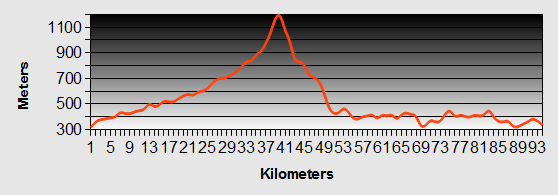
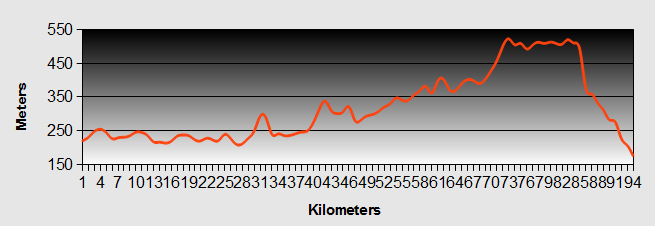
Fiordland - Day 1 - Haast to Makorora
- Distance 76km
- Max Elevation 546m
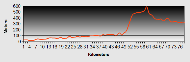
Fiordland - Haast to Makorora Ride Profile
Ride Description
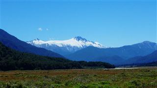
Today would mark our departure from the South Island's rugged west coast and provide us with some of the most stunning scenery yet as we venture into the South Island's Fiordland.
Over breakfast, a lady (Pauline to who we are eternally grateful) chatted with us about our ride from Haast to Fiordland. Her husband and some friends were cycling up the Haast valley to Makarora, the same place we would stay at that night. She knew how steep the hill was and offered to carry some of our bags in her car. Well, you can't refuse an offer like that. So with a lightened load we set of up the valley.
The wide flat alluvial plain continued for 40 kilometers up the valley. The Haast River snaked through the plain, turquoise blue in colour.
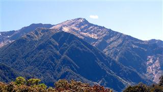
On both sides the mountains rose above us, the bush stopping about 700 meters and giving way to bare rocky peaks and coarse grassland. Beyond we could see the snow covered peaks of the higher mountains.
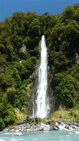
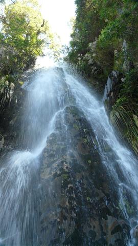
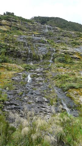
All along the valley waterfalls tumbled down the slopes or over the tops of rocky precipices. We stopped to walk to the Roaring Billy, Thunder Creek and Fantail Falls.
Having had days of hardly seeing any other cyclists today we saw seven all going in the opposite direction away from Fiordland.
At Pleasant Flats we stopped for lunch. We just managed to get in and out of the toilets before the Kiwi Experience bus arrived and disgorged hoards of young backpackers. We sought refuge in a quieter part of the picnic area to eat.
Suitably re-energised, or so we thought, we set off to climb the four hundred meters to Haast Pass. The road crosses the river at the "Gates of Haast". Here the gorge narrows with large cliffs at either side, with the water thundering through below. We renamed it the "Gates of Hell", as it was from here that the gradient increased to at least 15%. Even with our reduced load, we struggled, in 1st gear, to make progress. We must have stopped at least five times in one kilometre. The sun beat down and we were sheltered from the wind. When the gradient reduced and we were in the shadow of the cliffs, we stopped at a waterfall and stood, fully clothed under the wonderfully cooling water.
From there it was a much easier climb, gentler gradients continuing up the river valley to reach the top at 563m. It was rather an anti climax, with no dramatic views as we were still in the trees.
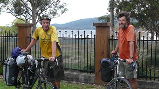
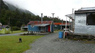
We dropped down into the Makarora valley to find the camp site complete with bar and swimming pool. Guy and Stephen arrived later and seemed a bit put out that they hadn't managed to catch us up during the day. They cheered up after a few pints in the bar.
Fiordland - Day 2 - Makarora to Wanaka
- Distance 58km
- Max Elevation 450m
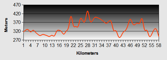
Fiordland - Makarora to Wanaka Ride Profile
Ride Description
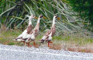
We got an early start today, stopping along the way to let these three locals cross the road.
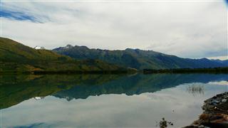
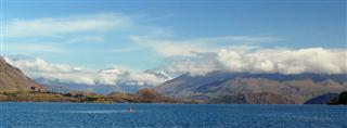
It wasn't long before we reached the start of Lake Wanaka which was at very high levels due to the rains, so much so that many of the fields leading to it were flooded, encouraging lots of bird life to rest there. It was an idyllic, calm and tranquil morning as we cycled along the undulating road by the lake. We stopped to take in the atmosphere as we looked across to the mountains that were mirrored in the still waters. As we watched the wind started to increase and soon the flat calm was lost to us.
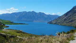
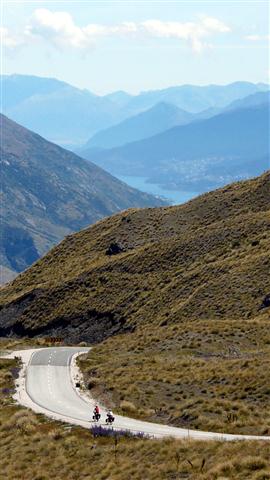
Lake Wanaka is over 1000 ft deep, putting its depths lower than sea level. The road rose gradually as we cycled half way along the lake, before turning eastwards to reach the 465m saddle between Lakes Wanaka and Hawea. The lakes lie parallel to each other running from north to south, but remarkably Lake Wanaka is 69 m lower than Lake Hawea.
The road drops down the other side to Lake Hawea and continues rising and falling with some steep climbs along the lake's west side. Shortly before commencing a long climb, a cyclist coming towards us veered over to our side of the road and stopped to talk with us. He was German and looked like he had just crossed the desert. His panniers were of a old, battered canvas ones and he wore cotton clothing with full length sleeves and trousers. Underneath his helmet he sported a floppy bush hat and around his neck he wore a worn and ragged scarf. He waxed lyrical abou the beauty of Fiordland and asked us if there was anywhere that he could get food between here and Haast, as he had set off without any. We thought it was a bit risky as the next shop was two days ride away.
The ride continued with hard ups and downs all the way to the end of the lake where we turned off to the Lake Hawea township for a spot of lunch.
It was a further 20km of hard up and down riding before we reached Wanaka, hot and tired.
Fiordland - Day 3 - Wanaka to Queenstown
- Distance 93km
- Max Elevation 1200 m
Fiordland - Wanaka to Queenstown Ride Profile
Ride Description
Steve was kept awake most of the night by a group of noisy, giggly girls (they just wouldn't leave him alone). As normal Karen slept through it.
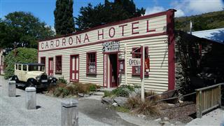
Our route took us up the wide Cardrona valley. It was a gradual climb from 300m at Wanaka to 600m at Cardrona, where we stopped at the old Cardrona Hotel, built in 1865, for a coffee. In the winter it is a popular ski resort and is the only Nordic skiing venue in New Zealand.
As we were leaving the hotel we stopped to speak to a road cyclist who was training to take part in the Wanaka triathlon. While we were chatting we spotted Stephen and Guy coming up the hill. The cyclist promised to delay them for us so that we could get a head start on the real part of the climb.
From there the gradient increased as the valley narrowed. It was sheltered from the wind and the sun was hot. About 2km from the top we both gave up the struggle of pedalling up hill in 1st gear and got off to push for about 500m. As we pushed, we spotted what we thought was a cyclist hurtling downhill towards us. As he came closer we realised he was a young man riding a skate board at around 30 mph pursued by his friends in a car who were filming him. They must have turned back up the hill and gone passed us, because he came skating passed us again for his second attempt. We didn't see him again so don't know whether he wrapped himself round a road sign or something.
The last 500m of hill were less steep so we were able to save face and cycle into the car park at Crown Saddle, crowded with tourists. At 1080m, this is the highest sealed road in New Zealand.
Collapsing on the grass we revived ourselves with lunch, a glass of wine and mug of tea. Stephen and Guy arrived about 40 minutes later. The views towards Queenstown, The Remarkables and the Crown Range were breathtaking. After a group photo at the top we took turns to film each other as we sailed down the steep hill towards Queenstown. As we careered down the lower half of the descent, the road twisted through several tight hairpins. It was magic!
Instead of heading straight to Queenstown we went via Arrowtown and met Stephen and Guy at the Arrowtown micro-brewery to sample their special ales.
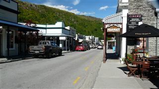
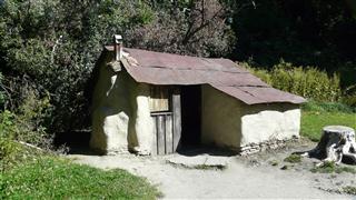
There is a renovated village in Arrowtown where the many Chinese gold workers lived in the 1800s. After a quick look around we took the wrong turn out of Arrowtown and ended up back on the main highway 6 into Queenstown, which was busy and fast.
Fiordland - Day 4 - Queenstown to Mavora Lakes
- Distance 43km
- Max Elevation 800m
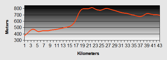
Fiordland - Queenstown to Mavora Lakes Ride Profile
Ride Description
During the night we were disturbed by other hostel guests who stood outside talking and smoking until the early hours.
The steam boat TSS Earnslaw departed from the wharf at 10-00am, with us and our bikes on it. It was a delightful restored boat with a steel hull, lots of wood and brass fittings. The main deck was given over to a lounge, cafe and bar. A young pianist tickled the ivories of a baby grand piano, (you could even buy a copy of his sing along CDs).
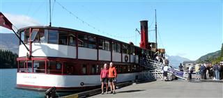
The wind had dropped and we had a calm crossing to Walter Peak Farm on the other side of the lake. Whilst we were cruising we met an English couple that had been on the Fiordland, Milford Sound overnight cruise and had in fact got married on board. How romantic! It stimulated our desire, not to get married, but to go on the overnight cruise.

From here the route was on a gravel road.
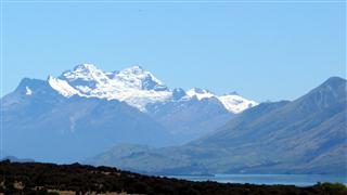
It was easy to start with, turning along the side of the lake with views up Glenorchy towards the snow covered Southern Alps.
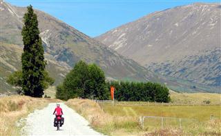
The track turned inland and upward following the Von River valley. After a short climb we came into a grassy flat bottomed valley with herds of brown and white cattle grazing freely. On two occasions we had to cycle passed sombre looking bulls. We pedalled quickly, not looking them in the eye, but they seemed more concerned with taking their calves and cows to safety rather than confronting us.
The track then started to climb steeply, winding its way into a strong cold head wind. We stopped half way up for lunch and to recover. As we were setting off again a young couple on mountain bikes came pushing up the hill. When we told them it was another 25km to Mavora Lakes they realised that it was too far for them and turned back, (wusses!)
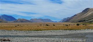
After a few short pushes, we completed the climb to 700m and came out onto a high grassy plain, bordered by bare mountains. The wind was even stronger and riding along the valley we could have fully expected an army of Orcs marching across the whole width of the valley.
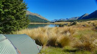
As we got close to the Mavora Lakes turn off, we came across a Swiss cyclist who had pitched his tent at the side of the track. He couldn't speak much English, but he had learned one key word, "Sand flies" and told us that the camp site at the lake was overrun with them. Rather than take his word for it decided to see for ourselves. We pitched at the side of the smaller south lake and the sand flies were not too bad as there was a strong wind.
Next to us was a young German guy called Michael. He had collected firewood and that night we sat chatting around the fire.
Fiordland - Day 5 - Mavora Lakes to Te Anau
- Distance 67km
- Max Elevation 650m
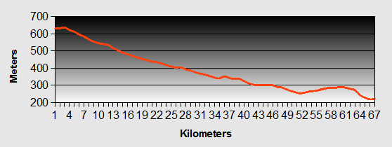
Fiordland - Mavora Lakes to Te Anau Ride Profile
Ride Description
The first half of today's ride continued on the gravel road. It was mostly flat, slightly downhill and much looser gravel than the previous day's section. There was regular traffic passing us, throwing up clouds of dust which covered us and our bikes. It was a relief to get onto the highway and some smooth tarmac. It was downhill all the way to Te Anau and our first experience of Fiordland.
We camped at the Top 10 site, and at $41 it was the most expensive camping we had paid for to date. Before we could do anything we had to turn the hose on our bikes and bags to remove the coating of dust. As we went to pitch the tent we realised that Stephen and Guy were on the next plot. They had arrived the day before and today had been walking part of the Kepler track.
Too tired to cook again, we treated ourselves to a pizza in the town, followed by beers with the lads.
The following day we took a day off to catch up on washing, shopping, blogging and booking our Fiordland, Milford trip. At the information centre we booked our overnight cruise and arranged to return from Milford to Queenstown on the bus. We managed to book a cabin at 'Gunn Camp' on the way to Milford. This meant that we could leave the camping equipment behind and cycle with a lighter load.
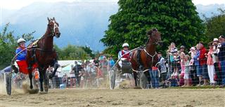
It was very windy and we felt sorry for Stephen and Guy who had set off to ride the whole 122km, through the stunning Fiordland terrain to Milford Sound. We were entertained watching the preparations for the harness racing that afternoon. The road outside the campsite was closed to traffic and was being transformed into a racing track, complete with wire fencing, thick sand over the tarmac, hospitality tents and spectator seating.
It was fun watching the races and we were tempted to have a bet but resisted. There was a large crowd of people watching as this was the first time for ten years that the races had been held. Health and safety regulations had almost put an end to this local tradition.
Fiordland - Day 6 - Te Anau to Hollyford
- Distance 94km
- Max Elevation 520m
Fiordland - Te Anau to Hollyford Ride Profile
Ride Description
It rained all night and Steve woke up in a puddle of water which had dribbled onto the groundsheet. We shuffled sideways a bit and he got back to sleep. By morning it had stopped and we got on the road early for our long Fiordland ride.
We had arranged to leave our camping gear at the 'Tracknet' bus office but had been given wrong directions by the tourist information girl. We turned up at the wrong campsite and had to ride back over the other side of town to the right place.
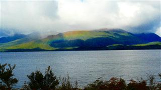
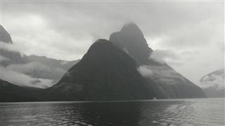
There was still a fresh wind blowing in our faces and low clouds sitting on the Fiordland mountain tops. A rainbow caused by the sun shining through the mist cheered us up.
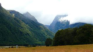
The Fiordland road followed the edge of Lake Te Anau for the first 30km before turning up the Eglinton River valley, slowly rising up to 'The Divide' at 480m. The valley floor was broad and flat with grass and beech forest and the low Fiordland cloud would lift every so often to show the towering sides with some patches of snow still in the shaded valleys.
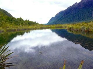
In the midst of the beech forest, we happened across the Mirror Lakes. They are crystal clear and in calm conditions, they give an almost perfect reflection of the Fiordland mountains on either side of the valley.
The road rose slowly up to 'The Divide' at 480m. From there we enjoyed a steep downhill into the Hollyford valley where we turned off down a gravel road to 'Gunn Camp'. This was where the workers building the Homer tunnel through to Fiordland's Milford sound had lived during its construction. The buildings have now been converted to a small museum, a shop and cabins for walkers.
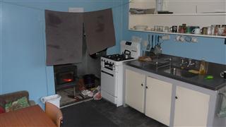
Our accommodation was a little 'worn' but at least we had our own bathroom, kitchen and small fire to keep us warm. Steve negotiated the purchase of an egg and a cup of flour from the site manager to produce delicious pancakes for pudding.
Fiordland - Day 7 - Hollyford to Milford Sound
- Distance 39km
- Max Elevation 920m
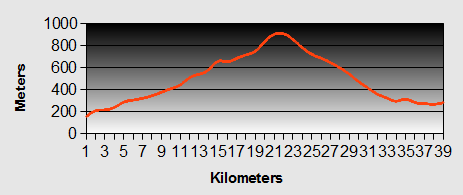
Fiordland - Day 7 - Hollyford to Milford Sound Ride Profile
Ride Description
Our prayers for a dry day were not answered and the drizzle and low Fiordland cloud continued today. Waiting until 10.00am to leave, we hoped to miss most of the heavy traffic and buses.
The 8km climb from the camp back to the tarmac took an hour and by then it had stopped raining. From there we headed uphill to climb the hill to the Homer tunnel, 650m in 10km. We enjoyed the ride up more than we expected to. There was some hard shoulder most of the way, the traffic was light, only about 8 buses passed us, and it was not as steep as we had feared. The views of the Fiordland hills must be wonderful on a clear day but we only managed a few glimpses.

Sooner than expected we arrived at the gaping mouth of Fiordland's Homer Tunnel. It was time to put on all our warm layers and as many lights and reflective bits as we could.
 Homer Tunnel Entrance
The traffic through the tunnel is controlled by traffic lights during the day, so that there is only one direction of vehicles to negotiate the narrow roadway. We waited until all the queueing traffic had gone before following. The road drops 1:10 downhill and there is only very faint background lighting. It is impossible to see the road surface which is uneven in places and constantly wet. There were waterfalls down the sides which we could hear but not see. It is not a road to rush down. About three quarters of the way down the lights changed and the uphill traffic started to come towards us. It seemed tremendously loud in the confines of the tunnel. We stopped to let it go by before heading towards the welcome 'light at the end of the tunnel'.
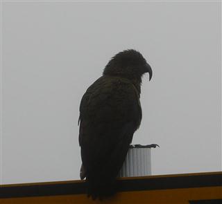
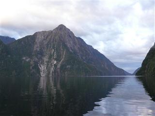
On the other side of the hill the Fiordland vies were obscured by low cloud. A solitary Kea sat on a roadside sign waiting for a car to wait at the traffic lights so that it could remove the rubber bits that it likes so much.
The downhill was fast and furious through hairpins and as it dropped the clouds cleared. The high, bare rock faces were covered in long thin waterfalls falling down to the thick forests at the base of the valley.
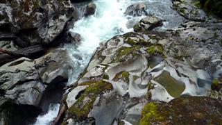
The trees were clothed in a spectacular amount of moss and lichen, witness to the amount of rain which falls here. We stopped at The Chasm to see the impressive water moulded rock formations. Unfortunately, so had several bus loads of tourists.
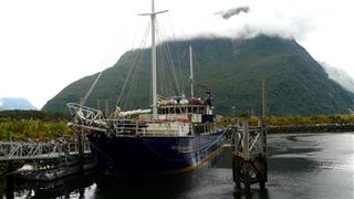
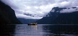
Our cruise on the Milford Wanderer departed at 4.30pm. The cabin for 4 wasn't big enough to swing a cat so we were glad to have it to ourselves. The food was great and the other passengers were mostly families with school age children.
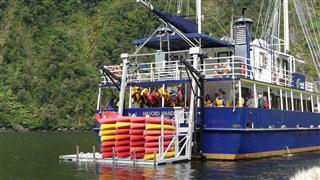
The ship cruised part way down the sound and then anchored in Harrison Cove where we went for a ride in the tender while others went out in kayaks or swam in the sound, jumping into the cold water from the top deck.
After our evening meal we watched the sun go down across the sound and experienced the peace and tranquility of Firodland....
Fiordland - Day 8 - Milford Sound to Arrowtown
- Distance 21 km
- Max Elevation 530 m
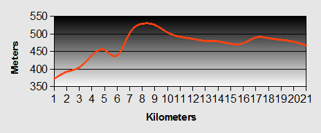
Fiordland - Milford Sound to Arrowtown Ride Profile
Ride Description
In the morning we were up at 6.30 and got a brief view of the still water, mirroring the high rocky walls and the long thin clouds, before the wind started and the rain came down.
After breakfast the boat cruised out through the Fiord entrance into the Tasman Sea, where there is a clear line showing where the dark coloured freshwater meets the lighter sea water.
 The Tasman Sea
By 9.30 we were back at the port to catch the bus back to Te Anau and from there to Queenstown, a five hour journey. At the bus stop in Queenstown we bumped into two separate travellers who we had met previously in the South Island.
Not wanting to stay in the expensive Queenstown again, we cycled 20 kms up the road to Arrowtown to camp.
New! Comments
Have your say about what you just read! Leave me a comment in the box below.