Gloucester to Plymouth
Gloucester to Plymouth was the final leg of our journey through Great Britain. We had travelled through some wonderful scenery and experienced the extremes of the late British summer. As the days were getting shorter and the temperatures dropping, we needed to head south and to warmer climes. But first, we planned to meet up with our son ad his girlfriend in Bromham.
Schedule
Our ride descriptions give an account of the ride that we completed. As part of the description we also provide links to Wikiloc or Google maps and elevation profiles based on mapping data available through the internet. The ride profiles are smoothed to give what in our opinion is a more beneficial view of the profile. We use paper maps, GPS and on line data to plan and conduct our rides. We are happy for you to use our descriptions, but be aware that we do not guarantee the accuracy of the information provided as situations surrounding any ride change over time.
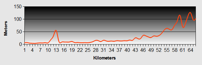
Gloucester to Plymouth - Day 1 - Gloucester to Malmesbury
- Distance 55km
- Max Elevation 190m
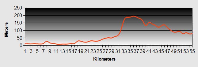
Gloucester to Plymouth - Gloucester to Malmesbury Ride Profile
Ride Description
Today we started the next leg from Gloucester to Plymouth. We had a very early start as Mark had to be in Gloucester by 8-30 for work. So we were up at 6-30. In the dark!! We breakfasted on porridge with maple syrup, packed the stuff into Mark's Mercedes and said our fond farewells to Anne-Marie.
Arriving at Mark's work in Gloucester we loaded up the bikes, said goodbye to Mark and set off along Sustrans route number 41 down the towpath of the Gloucester Canal. At one time Gloucester had been the biggest inland port in the UK.
As it was still early it was on the cool side, but the ride was pleasant and easy, eventually branching off the canal onto the Gloucestershire country roads, taking us briefly by the side of the tidal River Severn. At Frampton on Severn we switched onto route 45, which cut to the south of Stroud and through the village of Nailsworth.
Here we stopped at Hobbs Bakery and cafe to purchase bread and sample their fine coffee and cakes. We crossed the road to Williams Fish Market and deli. We bought fresh mackerel for our dinner. We continued out of Nailsworth up a 1st gear, but achievable hill riding across Minchinhampton Common to reach the Wiltshire village of Minchinhampton. We had missed their village fete by a couple of weeks, but they still had all the bunting up. Steve was keen to swipe a couple of Union Jacks to go with our Scottish and Welsh flags, but we couldn't find a way to reach them.
Minchinhampton is an historic village and still has its own dairy, where we bought some thick cream to go with our strawberries for dinner and some Blue Heaven cheese.
From there our Gloucester to Plymouth ride took us through gentle ups and downs, stopping briefly and gratefully to eat the lunch that Anne-Marie had prepared for us.
We arrived in Malmesbury at about 2-30 and headed straight to Burton Hill Caravan and Camping Park. The site was a nice site but didn't warrant the £13 per night fee. It does annoy me when these sites charge the same for us two with our little tent and bikes as they do for huge motor homes and caravans. They are just profiteering.
We cooked a lovely meal of Mackerel in onion, garlic, red pepper and tomatoes accompanied by new potatoes and purple sprouting broccoli. Fresh strawberries and cream, cheese and biscuits to follow all washed down with lashings of fine Italian soave wine.
By the time we had finished dinner the sun had set, the sky was clear and the temperature plummeted. Karen went for a shower to get warm, whilst Steve filled our bike bottles with hot water to turn them into hot water bottles for our beds. As it was still early we retreated to the campsite information room that had light and warmth, to complete our budget and blog and to plan the rest of our Gloucester to Plymouth route.
Gloucester to Plymouth - Day 2 - Malmesbury to Bromham
- Distance 40km
- Max Elevation 175m
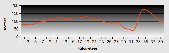
Gloucester to Plymouth - Malmesbury to Bromham Ride Profile
Ride Description
We woke to a warm sunny morning, but messed about a bit and got a bit of a late start. Cycled into Malmesbury, and picked up the Wiltshire Cycle Way that formed this part of our Gloucester to Plymouth route. It took us along easy unclassified roads heading south and at one point traveled along the Foss Way which is the old Roman road that runs from Bath to Lincoln and was a major trunk route for the Roman army.
We navigated around the west and south side of Chippenham crossing over the M4 and down to the A4. As we quickly crossed over the A4 into the village of Corsham we spotted a cycle tourist coming towards us along the A4, but we had no time to stop as we were hurrying to cross the road before the lights changed.
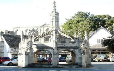
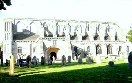
We headed into Corsham and stopped to decide our direction. As we did so the cyclist caught us up. He had been joined by another cyclist who was local and had cycled from Gloucester to Plymouth himself. He helped us find our way. It turned out that the tourer was American and traveling from Chippenham to Bath. We headed off in the direction of Lacock. Lacock is a lovely village largely preserved by the National Trust which owns the Lacock Abbey. We took time to look around the village and stop for coffee and cake at a local Cafe.
We stopped to buy postcards at the Post office and as we prepared to leave, a gentleman cyclist of more senior years stopped to chat about our tour and about our route. Roger Peacy is a fit road cyclist and a member of Bristol Cycle Club. He advised against the last bit of the route that we had planned due to a very steep hill and was happy to cycle (slowly compared to his normal speed) with us to show us the way to our destination in the village of Bromham. What a gent!
As we arrived Emma and Katie came out to meet us and welcomed us into Katie and Steve's home. Simon our elder son arrived later and Katie and Emma had prepared a succulent meal for us. It was great to see them all again, catch up on their lives and talk about our adventure.
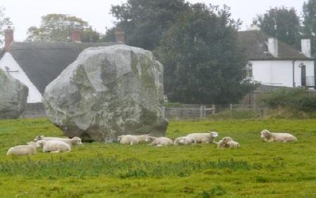
On Saturday Simon and Emma drove us to Avebury. Whilst perhaps not so well known as its more famous cousin, Stone Henge, Avebury is the largest henge in the world.
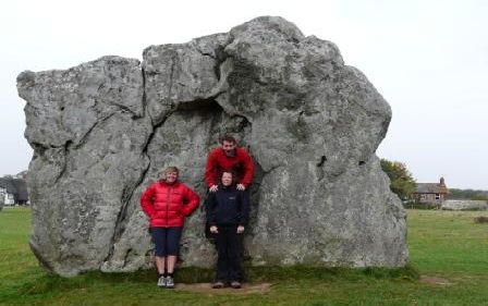
It is managed by the National Trust. It was a cold and rainy, but we braved the elements and walked around the stone circles.
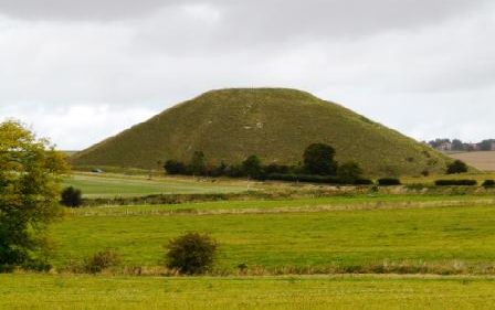
From there we travelled a short distance to Silsbury Hill, which is Britains largest man made hill and despite extensive scientific study over the years, no one is still any the wiser what it was actually for. Next we went to the Longbarrow .
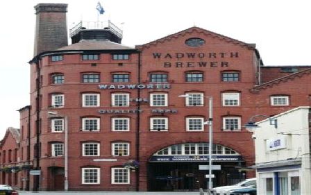
On Sunday we made a brief visit to Devizes and walked around the historic town. Unfortunately, it being Sunday, we couldn't visit the Wadworth Brewery.
Sunday afternoon and Simon and Emma said goodbye, on their way back to London, (Karen had a little weep).
That evening Steve's old friend, work colleague and boss over many years, Barry Webb and hiswife Julia drove up to take us out for a dinner treat. Great to see them both and talk about travelling around the World as they are also planning something similar, but in a little more style, on their ocean going cruiser!
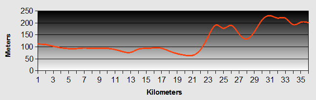
Gloucester to Plymouth - Day 3 - Bromham to Glastonbury
- Distance 89km
- Max Elevation 244m
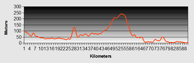
Gloucester to Plymouth - Bromham to Glastonbury Ride Profile
Ride Description
The weather was reasonable as we set off from Bromham, passing by the many market gardens along the way and for this part of our Gloucester to Plymouth ride picking up National Cycle Route No 4 along the side of the Kennet and Avon Canal, which made for an enjoyable and easy ride.
We were amazed at the number of people living on boats on the canal. We followed the canal to Bradford on Avon where we stopped for the "Full English." The Gloucester to Plymouth ride continued along the Canal to Limpley Stoke where we left the canal to pick up route 20 called the Colliers Way. It followed the line of the old railway that had previously replaced the original canal, long since filled in, arriving eventually in Midsomer Norton.
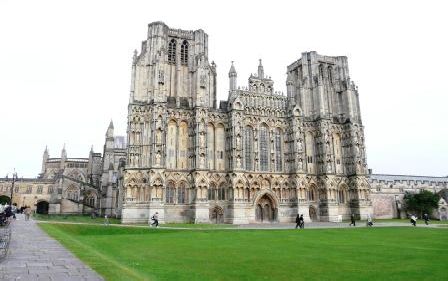
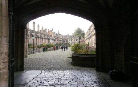
From here we navigated our own route to Wells along minor roads. Wells town itself is fairly small and as we dropped down the hill the Cathedral was dominant, dwarfing the rest of the town. It has to rank as one of the most impressive UK Cathderals that we have seen.
We spent a little time in the town marveling at the Cathedral before continuing our Gloucester to Plymouth journey towards Glastonbury, on route number 3.
This lead us through the flat land marshes known as the Somerset Levels and past the Peat Moors Visitor Center, where we glimpsed some of the round house huts built in the old traditional way.
Our impression of Glastonbury was disappointing compared to that of Wells. This may have been due to the lateness in the day, tiredness or reality, we couldn't really deduce which. We shopped quickly and found tourist information to find the nearest camp sites. We called one at Westhay which was only £4 per night! Bargain! The problem was it iwas 5 miles away, raining and getting dark.
As we headed through the town we were challenged to a race by three young lads on bmx bikes. If they won they would get our flags and if we won, we would get his handlebars! We politely declined the challenge, but they rode with us for a short distance and tried to help by giving us directions to Westhay.
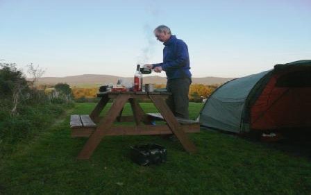
As we headed out of town we saw another close camp site. When they told us it would be £13 per night we carried on. The site at Westhay was a farm with shower and toilet, but was all we needed and cheap. We pitched and cooked by torchlight.
Gloucester to Plymouth - Day 4 - Glastonbury to Greenham
- Distance 65km
- Max Elevation 131m
Gloucester to Plymouth - Glastonbury to Greenham Ride Profile
Ride Description
Whilst we packed we chatted with a couple in a camper van who were also keen cyclists and travelers andwanted to know about our Gloucester to Plymouth ride. Geoff and Helen actually came from Westhay village, but lived in Melbourne, Australia. Geoff made us a real coffee whilst we talked. Before we left they gave us their email and offered accommodation when we are in Oz.
We made our way to get back on our Gloucester to Plymouth ride on route 3 and cycled along the old peat moors and arriving in Bridgewater along the side of the River Parrett. We headed straight to St John Street Cycles, home of the Thorn Bike factory to pick up a few essential spares for our trip and a new cycle helmet for Karen. A hundred quid or so lighter we went to find a greasy spoon cafe in the middle of the town. Bridgewater has no redeeming features and after lunch we headed straight out of town along the side of the canal all the way to Taunton.
The tourist information guy in Taunton told us that the nearest camp site on our Gloucester to Plymouth route was about 5-7 miles out of town on route 3. We cycled along country roads crossing valley after valley with several fairly steep climbs, making for tiring riding.
Along the way we met three guys on touring bikes, cycling towards us. They seemed genuinely pleased to see us and stopped to chat about our Gloucester to Plymouth route, etc. They were doing the Coast to Coast ride from Padstow to Bristol. This was their first long distance ride and they were ill prepared for the journey. They looked exhausted. They were heading for bridgewater which was still about a 3 hour ride away. At this time it was about 4-30pm. They had the advantage that they were staying in B and Bs.
We arrived at Greenham when it was almost dark and hunted around the village for a about 30 mins to find the site, which we eventually found up another final hill. The tourist guy's 5 miles had amazingly ended up as 12 miles.
The site was a good one at only £6 per night. Another bargain!
Gloucester to Plymouth - Day 5 - Greenham to Nomansland
- Distance 36km
- Max Elevation 233m
Gloucester to Plymouth - Greenham to Nomansland Ride Profile
Ride Description
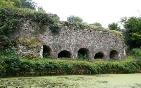
We had a slighty up and down ride initially, on a cloudy, but dry morning. Our Gloucester to Plymouth ride today took us along the Grand Western Canal extension which was built to service the Waytown Quarry. The remains of the original Limekilns are still to be seen.
We rode into Tiverton to the Tiverton Basin where they still operate a horse drawn barge, for the tourists.
We did our shopping and then went to a lovely cafe for lunch at which point it started to rain heavily. We waited it out, but it was still raining as we emerged and looked for the tourist information. Here we left route 3 which heads north and our Gloucester to Plymouth route continued, navigating our own way across to Oakhampton.
We found the nearest camp site was some 7 miles away at a place called Nomansland. We phoned to establish the price and they warned us that the hill out of Tiverton was steep. They called it Long Drag Hill. They were not wrong. We battled through pouring rain up the long hill and several more after that to reach the site. It was still raining as we pitched. We were pretty miserable and had to cook our dinner in our tent.
Gloucester to Plymouth - Day 6 - Nomansland to Lydford
- Distance 50km
- Max Elevation 295m
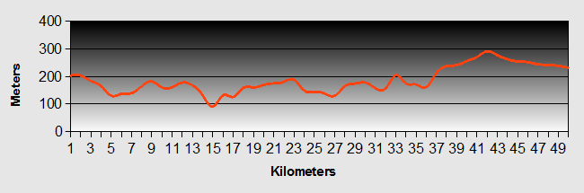
Gloucester to Plymouth - Nomansland to Lydford Ride Profile
Ride Description
Overnight the rain had stopped and the sky cleared resulting in a very cold night. (Someone that we met even suggested there had been a frost that night).
We had a late start, waiting for our tent to dry. The morning was sunny and warm and we stopped at Witheridge for lunch provisions. It was an easy ride downhill most of the way to Lapford, where we crossed the main A377 and started the steep climb up the otherside of the valley. As we climbed out of the village we spotted a house selling Corn on the Cob at its gate. We bought a couple for 20p each.
We cycled across a couple of steep sided valleys and as we reached the top of one hill we heard farm machinery and saw corn dust floating across the road.
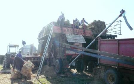
Lo and behold there in the field was an old fashioned threshing machine with about 8 men of older years working it.
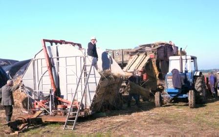
They welcomed us in to take photographs and we spoke to Jonathon, a retired farmer and Richard the youngest member of the crew, but actually the boss man.
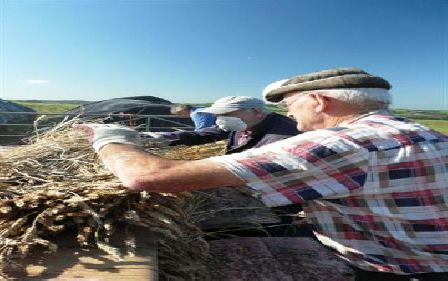
They were threshing corn for thatch using the old traditional methods. They worked all year round stopping only briefly for time off. Apart from Richard the whole crew where retirees and jokingly called themselves "Dad's Army".
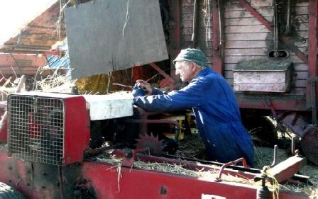
The threshing machine was a Marshal thresher that was 82 years old and last year produced 800,000 bushels of corn thatch. They work on a contract for the thatchers who own the corn grown by local farmers. It was fascinating to watch this work which was not without some significant risks as the guys fed the corn into the thresher drum.
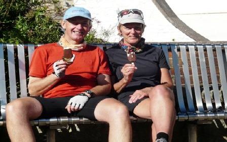
We continued on to Oakhampton and for the first time on out trip, we sat and ate an icecream.
We also chatted to a cyclist couple just out for a days run and they gave us good information about the rest of our Gloucester to Plymouth journey through to Tavistock.
Our Gloucester to Plymouth route was fairly steep out of the town, up onto the old railway line called the Granite Trail. The Trail took us past the still working Meldon Quarry and over the Meldon Viaduct.
After a few miles the route drops off the railway crossing over the main road and onto narrow back roads with the old ups and downs.
We were heading for a site at Tavistock, but as time was marching on we decided to stop at a site in Lydford. Here, we met the couple that we had previously chatted with In Oakhampton who invited us into their camper for a glass of wine during the evening. We chatted about our and their plans and swapped details. Thanks Mike and Sue for your hospitality.
That night our Michelin Star Chef, Steve cooked us another delicious meal of mackerel and we sat and ate looking across towards Dartmoor.
Gloucester to Plymouth - Day 7 - Lydford to Plymouth
- Distance 45km
- Max Elevation 287m
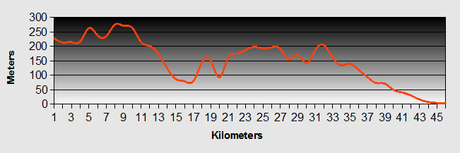
Gloucester to Plymouth - Lydford to Plymouth Ride Profile
Ride Description
We set off today thinking that the day would be an easy one as we understood the Gloucester to Plymouth route followed the old railway line into Plymouth. The ride into Tavistock started off up hill reaching its peak at Bentor.
We couldn't fathom how on earth the church, sited on top of the tor, manages to get a congregation each Sunday.
From there it was downhill into Tavistock. The route out of Tavistock along the 27 was steep and ended up going back down into the valley and onto a bridal path, which went back up hill. As we started our ascent we met a group of elderly mountain bikers that had turned back as it was too rough and steep. We continued on getting off to push up the rough track. Before we got to the really rough part that the riders had told us about we decided to climb over a locked gate to get onto the main road that passed close by. We unloaded all of our gear and lifted it and the bikes over the gate.
There then followed a dangerous ride along the busy main road for about 1 mile to the next trail access point. When we arrived there, it turned out we still had a push up a very steep rough shale track covered in slippery wet leaves ,with a couple of narrow gates thrown in increase the challenge, to get up onto the railway viaduct. For the first mile the track was muddy and very uneven and we wished we'd stuck to the road. From then on it was smooth tarmac and the gradient was gently downhill so we were soon on the outskirts of Plymouth and on our way to our final campsite in England at Riverside Caravan Park. Despite being close to Plymouth and several large industrial and retail parks this was a quiet and secluded place but just as we arrived the heavens opened and we had to wait to pitch until it abated and then once again we cooked in the tent as the rain poured down.
We had reached our destination. We had completed the Gloucester to PLymouth leg of our end to end ride. For us the journey hadn't finished, for we were on our way to Spain. Read about it on our Spain Pages.
Link Back to our Tours Page from Gloucester to Plymouth
New! Comments
Have your say about what you just read! Leave me a comment in the box below.