Yeonghae-Busan-Bicycle-Ride
From South Korea's East Coast to the
South West and Along the South Coast to Busan
The Yeonghae-Busan-Bicycle-Ride formed the second leg of our South Korean adventure. We had landed by air into Seoul's Incheon Airport and taken a taxi into the center of Seoul city. After a couple of days sightseeing we rode east from Seoul and then north to Chuncheon within a stone's throw of the North/South border, before heading south east to reach the east coast of South Korea at Yeonghae.
The next leg of our trip would take us south west all the way to island of Wando at the south west corner of the Korean peninsula. From there we cycled east again along the southern coastline to reach the resort town of Yeosu where necessity found us performing some major repairs to our bicycles. The final day took us by bus to Busan for a little R and R before catching the ferry to our next port of call Fukuoka, Japan.
Schedule
Our ride descriptions give an account of the ride that we completed. As part of the description we also provide links to Wikiloc or Google maps and elevation profiles based on mapping data available through the internet. The ride profiles are smoothed to give what in our opinion is a more beneficial view of the profile. We use paper maps, GPS and on line data to plan and conduct our rides. We are happy for you to use our descriptions, but be aware that we do not guarantee the accuracy of the information provided as situations surrounding any ride change over time.
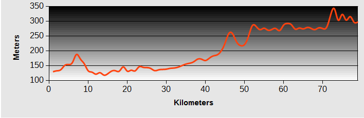
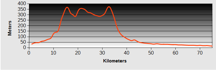
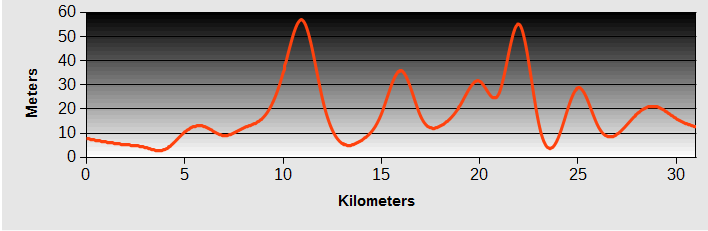
Yeonghae-Busan-Bicycle-Ride : Day 1 - Yeonghae to Andong
- Distance 95km
- Max Elevation 500m
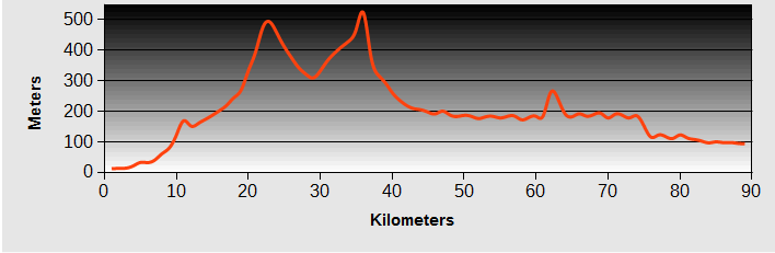
Yeonghae-Busan-Bicycle-Ride : Yeonghae to Andong Ride Profile
Ride Description
Re-invigorated after a day off yesterday, we set off with renewed strength in the legs, helped by a good breakfast and the fact that it was our 36th wedding anniversary. We left Yeonghae on NR 918 which climbs gently up a river valley through small farms and orchards. This area grows a lot of chillies and the bus stops and lamppost decorations were based on rather tacky big plastic ones.
 Tacky bus shelters
The trees in the orchards were heavy with ripe red apples and huge peaches.The abundance of fruit was surprising, given how expensive it is to buy fruit here: apples 1 pound each, peaches nearly 2 pounds. Above these the steep hillsides were covered with broadleaved forest.
 Apple Orchard
At about 400m above sea level the climb steepened but it was only another 100m climb to the col and a long descent to Jimbo, stopping on the way to view a 'Mountain Village' reconstruction.
 Bark Roofed Mountain Houses
We had planned to overnight in Jimbo but it was only 2.30pm and Andong was just 35km further so we carried on. At this point Karen discovered that she had lost her bike computer somewhere in the previous 10km. Damn.
 Traditional Fermenting Pots
A passing motorist stopped and handed us a much appreciated bottle of cold water through his car window. From Jimbo the road was a roller coaster along Highway 34. The traffic was light and there was a broad hard shoulder most of the time. The road dropped down to, and crossed, the reservoir formed by the Imha Dam and from there it was fast and flat all the way to Andong with the last 5km on a cycle lane.
Yeonghae-Busan-Bicycle-Ride : Day 2 - Andong to Sangju
- Distance 83km
- Max Elevation 138m
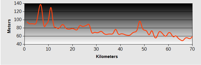
Yeonghae-Busan-Bicycle-Ride : Andong to Sangju Ride Profile
Ride Description
It was a late start this morning following breakfast at Dunkin Donuts ( not very nice donuts!). We planned to leave Andong on the cycle path which runs along the banks of the Nakdong River. There was just a four lane highway and a railway to get over to reach it.
The highway was very busy but we managed to get into the left lane to turn left at the traffic lights and get us onto a bridge over the river. Luckily we spotted a sign prohibiting bikes before the lights changed and made a quick lane change. This was a new road bridge, not the one on our map. At the next lights we picked up a cycle lane, over the railway and onto a special bike bridge over the river.
 Sculpture on Cycle Bridge
Running along the wide river banks, well away from any roads, the cycle path was peaceful and the sun was shining again . There was no-one around and not any other cyclists.
The river follows a meandering path through the low hills and the cycle route cuts across a couple of these on minor roads. So there are two quite steep but short ascents. They are signed as 7% gradients but are much steeper than that. They did have the benefit of giving some beautiful views of the river.
 Nakdong River
About twenty kilometres from Andong we turned from the river to visit the ethnic village and mask museum at He Hoe. This is a big tourist attraction although this morning it was quiet. The mask museum was fun, exhibiting not only the traditional Korean masks, but also examples from all over the World.
 Mask Man
When we returned to the bikes, Karen's tyre was flat. It had punctured over a spoke hole. Steve repaired it but it punctured again in exactly the same place as he inflated it. After re-doing the patch he blew it up again and it punctured in a different place. Time for a new inner tube.
The ethnic village was 1km further along the road so we left bikes at the ticket office under the watchful eyes of the two guys selling tickets and caught the free shuttle bus down to the village. Actually it would have been better to go down on the bikes and ride around the village.
 Traditional dress
We were a bit disappointed with the village. Lonely Planet waxed lyrical about how authentic it was with its dusty roads and lively village life but we found all the roads have now been concreted so that visitors can hire electric carts to ride around in. All the buildings have been rebuilt, nobody seemed to be living there. It all seemed too scrubbed up and perfect.
 Thatched village houses
Because of the puncture delay we didn't set off again until 4pm and still had more than 50km to ride to our planned destination. We rode like demons along the cycle path. In the late afternoon there were a few more cyclists about. A couple of young men on mountain bikes had no idea of why and when to change gear. At an uphill ramp both of them ground to a halt because they were in a high gear. We nearly crashed into them as we changed down and powered up the ramp.
 Dusk views approaching Sangju
With daylight starting to run out we checked the map and saw that it would be better to leave the river and go cross country on NR 914. This took us through cattle country but all of the beasts were in sheds, not grazing green fields. There were a few low hills to climb but some fast descents as well.
A man in a car tried to have a conversation with Karen while she was hurtling down a hill at 30kmh and he was driving on the wrong side of the road with traffic having to swerve past him. The sun set impressively behind the hills and we had to put the lights on to get into Sangju, through the rush hour traffic, and find a hotel.
Yeonghae-Busan-Bicycle-Ride : Day 3 - Sangju to Yeongdong
- Distance 59km
- Max Elevation 280m
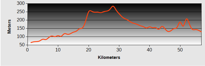
Yeonghae-Busan-Bicycle-Ride : Sangju to Yeongdong Ride Profile
Ride Description
After our hard day yesterday we had no appetite to get up early. As we went to put bags on bikes we remembered that Karen's Rohloff hub had an oil leak which was dripping onto her wheel rim and making the brakes squeal. The next 90mins was spent in a cafe drinking coffee while Steve made some phone calls to determine whether there was a Rohloff supplier in South Korea who could do a repair.
While he was busy with this Karen was entertained watching a big military parade which was going past the cafe window. There were a couple of military bands, lots of marching soldiers and vehicles towing field guns. It went on for quite some time and all the traffic was backed up down the street. A little old lady came along. She was tiny anyway but also had a badly bent back.
She was determined to cross the street and was probably old enough to remember the war. A soldier on traffic duty asked her to wait but she wouldn't listen and set off in front of a huge lorry. Another two soldiers joined in the restraint and managed to hold her back for a minute or two but she ignored all three of them and crossed the road.
 We love the spelling problems in Korea
By this time we had decided that the easiest way to repair the gear hub would be to order the spares we needed from England and get them shipped to Korea and get our nephew to courier the tools and spare parts we already had in storage in the Philippines to us. The plan was to take a couple of days off in Yeosu so we had them shipped to the already booked hotel.
We set off on a different route from the original plan. The Korea Tourist Map showed a bicycle museum about 5km down the NR25 so we went this way in hope of finding something interesting. It was no great surprise when no bicycle museum materialised. The villages along the way were smelly with intensive cattle sheds.
Turning onto NR 901, we rode through gentle valleys planted with acres of black grapes interspersed with rice, beans, apples and peaches. Each bunch of grapes was carefully enclosed in a special paper bag and the harvest was well underway.
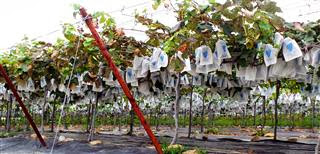 Grapes Ripening in Bags
Ladies were sitting at side of road packing the grapes into boxes and as we stopped to take photo they gave us a couple of bunches to try, delicious dark blacked skinned muscats.
 Grape packing
For our picnic lunch we stopped at a shady little rest house in a village. It was a busy place with villagers coming and going to the field on tractors and on foot.They were all happy to see two foreigners, waving and smiling at us.
Walking out to find some food that evening we came across the most adorable puppy in a pen at the roadside. Had he not been quite so big we might have stolen him.
 Yeongdong Boxer
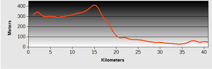
Yeonghae-Busan-Bicycle-Ride : Day 4 - Yeongdong to Jinan
- Distance 80km
- Max Elevation 345m
Yeonghae-Busan-Bicycle-Ride : Yeongdong to Jinan Ride Profile
Ride Description
It was raining again when we woke. Steve's tyre was flat and he had a problem with his gears. With those problems sorted we set off in search of breakfast but once again everywhere offering coffee was closed at 9am. Koreans only seem to drink coffee in the evenings and the shops don't seem to open till around lunchtime. so we brought cakes at a bakery then went into a 7/11 and got coffee.
The rain continued steadily for the rest of the day as we gradually gained altitude riding up a river valley on highway 68. This area is famous for its ginseng. The valley is beautiful with some high water cut cliffs and attractive waterfalls but it is also the site of yet another motorway building project.
 Waterfall Near Jinan
Arriving at the outskirts of Geumsan we found ourselves in a busy road junction between the new expressway and the highway, a six lane road which we had to cross to escape onto a local lane. Today was ginseng market day and there were long queues of cars and buses and lots of security.
|
With no let up in the rain by lunchtime, we needed to find shelter to eat our picnic lunch. An ideal rest house was already occupied by a group of Korean tourists. Like all Korean coach tours they had brought everything with them, tables, chairs,barbecues, food and drink. A lot of them were eating, sheltering in the luggage spaces under the bus. The next rest house was outside a post office. We made ourselves comfortable and the post office manager came out to see if we would like a cup of coffee. |
 Rest House Lunch Rest House Lunch |
|
Further up the valley is a large reservoir and we turned on to NR 795 along its western shore. With the low cloud and grey skies it was difficult to appreciate the views. |
 Reservoir Near Jeanju Reservoir Near Jeanju |
The low mood continued when we arrived in Jinan with very few accommodation options. The first one was dirty and only had ondon (i.e. mats on the floor) rooms. Over the road was a slightly better option, at least it had beds, but the pillows were gross, filled with something which felt and sounded like hula-hoops.
Yeonghae-Busan-Bicycle-Ride : Day 5 - Jinan to Jeonju
- Distance 39km
- Max Elevation 420m
Yeonghae-Busan-Bicycle-Ride : Jinan to Jeonju Ride Profile
Ride Description
On the outskirts of Jinan is Maisan Mountain, which in Korean means 'Horse's Ears'. The two steep sided peaks do look exactly as the name describes and we set off to have a closer look.
 Horse Ears Mountain
Following the signs from the town, we arrived in a large car park at the foot of the peaks. It wasn't obvious where the path to the summit started. Also there was a small electric powered bus picking up walkers. With all the seats filled the driver set off and seeing us on the bikes he gestured for us to follow him.
It set off climbing an old tarmac road, now closed to traffic which took us about half way up the mountain.
From there we continued on foot up a fixed stairway together with a large party of Korean hikers. The peaks are only 685 m high and the access is by stairs, but every one of these hikers was dressed and equipped for an Everest attempt, with sticks, boots, gaiters, rucksacks, probably gloves and thermals as well. The conglomerate rock which forms the mountain looked like magnified concrete with huge boulders bonded together.
 Maison Peak
Returning to Jinan we took Highway 26, a four lane dual carriageway towards Jinan. Having accessed it up a slip road we realised that there was a separate cycle path on the other carriageway but even if the traffic had been light enough for us to cross, the continuous central crash barrier prevented us accessing it.
Eventually we reached the next junction and crossed over to the cycle path. At Sinjeong the cycle path stops and we turned off onto the old road, climbing a quiet rural valley along a tree lined road. At the summit was a short tunnel and then a long easy downhill to rejoin the highway for a few more kilometres.
 Sculptures mad of old ceramic pots
Closer to Jeonju we took another minor road along the river and into the city centre. It was Saturday and the pedestrianised city streets were thronged with shoppers. We had booked in advance, at the Jeonju Benikea (Best in Korea chain) which lived up to its name and was right in the centre of town.
 Jeonju Flags
Opposite the hotel was a large church and that evening they were hosting a free open air opera concert which we enjoyed.
 Open air concert in Jeonju
Jeonju - day off
Jeonju is a vibrant modern town with a just a sprinkling of old, enthusiastically restored buildings. As it was Sunday they were all heaving with Korean tourists.
 Jeonju City Gate
 Old Shop
 Jeonju old wall
Yeonghae-Busan-Bicycle-Ride : Day 6 - Jeonju to Jeongeup
- Distance 53km
- Max Elevation 160m
Yeonghae-Busan-Bicycle-Ride : Jeonju to Jeongeup Ride Profile
Ride Description
Today was one of those 'same same' days with no significant sights or events. The low clouds obscured the mountain tops and the lower slopes were forested. In the valleys were mile upon mile of rice paddies as this area is called the rice basket of Korea.
 Harvesting
The road edges have overhead electric cables and most are planted with young trees. Between the two are massive webs with equally massive spiders sitting on them, waiting for the next tasty morsel to blunder into their trap.
 Massive Spiders
A long line of lorries was being loaded with huge conifers their massive loads being carefully strapped into place but the crowns protruded so far from the backs of the trailers that we hoped they didn't have many corners to negotiate in their journey.
 Tree Transport
About 11.00am we started to yearn for a cup of coffee and saw a roadside sign advertising the same. Riding up the drive took us to a smart restaurant with a big car park decorated with twelve Korean horoscope statues. We went inside but there was no-one around. We used the toilets, wandered round the restaurant and kitchen and shouted but to no avail. So no coffee this morning.
 Expensive Sculptures - No Coffee
It is slowly dawning on us that the reason why we find Korea so difficult is because greetings here, even between close friends, are very formal with bowed heads. Smiling, waving and eye contact are not things that they are comfortable with. So very few waves or 'hi's' as you travel around.
The whole day we rode on old roads at the side of the new highways so the traffic was light. Coming into Jeongeup we passed groups of school children walking home from school. In most other countries they would have giggled and maybe waved or shouted, but here they completely ignored us.
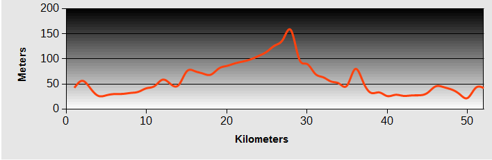
Yeonghae-Busan-Bicycle-Ride : Day 7 - Jeongeup to Gwanju
- Distance 83km
- Max Elevation 325m
Yeonghae-Busan-Bicycle-Ride : Jeongeup to Gwanju Ride Profile
Ride Description
Just to the sough of Jeongeup is the small Naejangsan National Park which has a circle of mountain peaks that are joined by a 'via ferrata' path with ladders and bridges and accessed by a cable car.
 Naejangsan Reservoir
We thought we might enjoy the challenge but having ridden up there we found the cable car only runs in high season. On the way we passed the memorial to the Donghak farmers rebellion of 1895.
 Farmers' Rebellion Memorial
So we had to content ourselves with a walk around the Naejang Temple and the beautiful valley which was peaceful and quiet on a Tuesday morning.
 Naejang Sa temple
 Naejang Gateway Figures
As we rode back into the tourist village at the park entrance we could see our route on the NR 49, skirting the hillside way above us.
It was actually an easy and enjoyable climb along the valley opposite the temple, giving us views back to the national park. The roadside has been planted on both sides with maple trees and their leaves were just starting to change colour. In four weeks time they would all be deep red and orange.
 View of Naejang from the road
Once over the col we dropped to a high plateau of more rice paddies with harvesting in full swing. It seemed strange to see small combine harvesters doing the work, unlike the hard labour of hand cutting in the poorer Asian countries. The rice mills were churning out clouds of bran dust which blocked our noses and gave us sneezing fits.
On the outskirts of Damgang we picked up a cycle path along the river bank. This meant we could get all the way into the centre of Gwangju city without having to negotiate the roads. The downside was that it was a very long way round. It did give us a good tour of this massive urbanisation. All around the outskirts there were groups of new tower blocks of flats under construction. In between these were little pockets of agriculture; greenhouses and rice paddies.
Nearing the city centre it was the usual problem with the cycle path along the river idea. There is usually a path on both banks of the river, one designated for walking and one for cycling. But we always seem to manage to end up on the wrong side and then can't find any way to get across to the right side. Also, once on the riverside, which is always well below street level, there are very few exits.
We booked a motel near the river and that evening treated ourselves to an Indian meal. The vindaloo and mango lassi were divine.
Yeonghae-Busan-Bicycle-Ride : Day 8 - Gwanju to Yeongam
- Distance 74km
- Max Elevation 350m
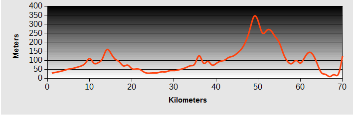
Yeonghae-Busan-Bicycle-Ride : Jeongeup to Gwanju Ride Profile
Ride Description
We were able to make use of the river pathway again this morning to get out of the city. Once again we were on the 'footpath' side but there were very few people walking. At the place we needed to exit there was only a set of steps up to the road so we had to take the bags off and lift everything up to the top.
 Gwanju Cyclepath
Several heavy showers during the morning slowed us up as we had to take shelter and then raised the humidity to uncomfortable levels. We rode south on the quiet NR817, heading to the temple at Unju-Sa. On the way we made a short detour to the Hwasun Dolmen site. This area has a huge number of ancient dolmen, large rocks balanced and levelled on smaller rock bases. They cover quite a large area and in pouring rain under grey skies we only saw a few of them.
 Hwasun Dolmen
Unju-Sa is a temple set in a beautiful steep sided gorge, surrounded by lots of unusual stone sculptures and pagodas.
 Unju Sa Buddha and Pagoda
There are rocky outcrops with Buddha images carved on them and ancient old gnarled pine trees clinging to the towering cliffs. With the rain gone and the clouds lifted the camera was kept very busy.
 Unju Sa Carvings
 Unju Sa Golden Buddhas
Sightseeing over, the next problem was to find a route to our planned overnight stop in Yeongam. It looked like we would have to go all the way back north, nearly to Gwangju again before we could turn west.
Then we spotted a minor road which ran up a valley and appeared to stop at the top. The sat nav showed a track going over the top of the valley and then dropping into the next one, saving about 25km.
The first section was a tarmac road which climbed gently up a rice paddy valley. It ended at a small village and it wasn't easy to find the rough track which wound through a couple of farms and barns and started to climb up the hill. After another kilometre it became a narrow concreted lane with overhanging high grass and trees. There was a thick layer of algae growing on it and with the shade of the trees and high humidity it was very slippery meaning the bikes had to be pushed up the steepest sections.
This was the hardest climb we had done since Taiwan.The valley was completely deserted and no vehicles passed us. The gradient improved further up but continued relentlessly upward. Drenched with sweat we reached the top and started the equally steep downhill into another little village and a proper surfaced road. There were still a couple of climbs to endure with tired legs before arriving at Yeongam about 5.30pm.
Yeonghae-Busan-Bicycle-Ride : Day 9 - Yeongam to Haenam
- Distance 42km
- Max Elevation 170m
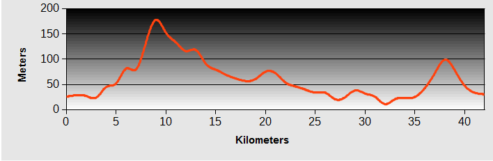
Yeonghae-Busan-Bicycle-Ride : Yeongam to Haenam Ride Profile
Ride Description
The aching legs wouldn't get out of bed this morning so we had a late start. We had hoped to be able to go for a walk in the Wolchulsan National Park, just to the south of Yeongam, which has some beautiful rock formations. But the cloud was still very low and there would be no views so we decided to continue south, keeping to the flattest roads.
 Wulchulsan Mountains
We did see a few rocky pinnacles sticking through the clouds. The road went through Girin, reportedly the oldest village in Korea, but it was much the same as all the other places we have ridden through, ramshackle concrete town with a small, old style, rebuilt section which was closed today anyway.
 Ethnic Village
Further along the road was an interesting memorial garden built in memory of a Korean scholar called Wang-In who taught the 1,000 character Chinese alphabet to the Japanese royal family.
 Half of the 1000 Character Chinese Alphabet
The morning was spent on the old 13 road, lovely and quiet now most of the traffic uses the new 'improved, widened and straightened' version. It was fine until we approached the intersection of the 13 with the expressway. Suddenly there was no remnants of old road and it looked like we would have to go through the intersection. But we turned left onto a narrow concrete village road, through rice and vegetable fields, using the sat nav to navigate the frequent confusing junctions.
Most of the traffic seemed to turn onto the expressway, leaving the 13 a very peaceful road but a little further on there was yet another old section. so two parallel roads with no traffic, just us and our bikes. The road ran along the side of a wide river flood plain which, in the spring, is a breeding area for hooded cranes. It reminded us of the Humber valley.
 On the way to Wando Island
We arrived in Haenam by 2.30pm and although the motel offerings didn't look too good, we found one with a lovely, helpful and generous owner who communicated with us via his phone translator app. The icing on the cake was the wonderful 'western' style three course evening meal at a local eatery. We felt full for the first time for days.
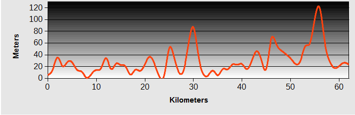
Yeonghae-Busan-Bicycle-Ride : Day 10 - Haenam to Wando
- Distance 55km
- Max Elevation 60m
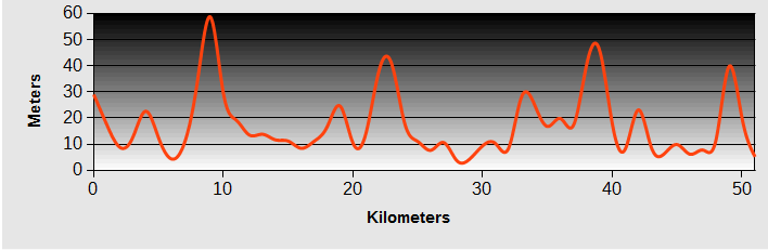
Yeonghae-Busan-Bicycle-Ride : Haenam to Wando Ride Profile
Ride Description
Today's ride saw us continuing on Highway 13, again using the old, parallel road, heading for the south coast of Korea. The farmland we rode through was varied, growing sweet potatoes, garlic and lemons. The road was quiet and the views long but marred by the persistent low cloud and haze. The high humidity continued and made it feel very hot whenever the sun got through the clouds.
 Coastal Rice Fields
It was low tide when we arrived at the gently shelving coast and long, dark coloured mud flats seemed to stretch for miles, with just a thin strip of pale sand at the high tide mark and a flat calm sea just visible in the distance.
 Fishing Huts
Our route now was on Highway 77 which in the future is going to be a major southern arterial road, joining the many offshore islands of the south coast by long bridges. Only a few of them have been completed so far but several more are under construction. From the mainland we crossed the first bridge onto a small island and then continued to the next, longer one connecting to Wando island. As we approached the bridge there was a warning sign of a motorway 700m ahead. Our map didn't show the 77 as a motorway and we weren't sure if there was an exit after the bridge before the motorway began.
At one side of the bridge was a pedestrian path, so we rode along that, reasoning that there must be an exit for pedestrians. There was, but it was a rough, steep concrete ramp running down to a rough area of grass about 300m wide before we could get back onto a road. The old road runs along the coast to the south-eastern port of Wando which is atypical port town. the whole seaside strip is lined with motels but only a few have a reception or staff on duty. We tried a few and then booked into the first one with a 'person' .
 Yi Sun Sin
We had a vague idea that we could get a ferry to the island of Jeju and then get a ferry back from there to Yeosu, further east towards Busan. But according to the lady at the ferry ticket office there was no boat back to Yeosu, so we would continue riding east along the coast.
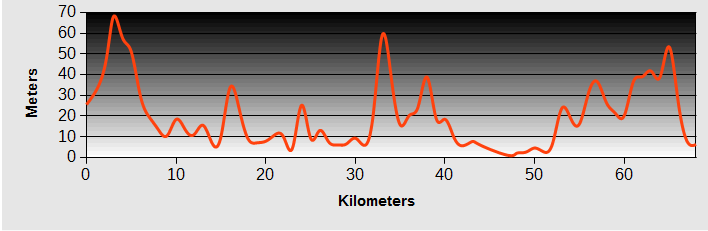
Yeonghae-Busan-Bicycle-Ride : Day 11 - Wando to Jangheung
- Distance 66km
- Max Elevation 120m
Yeonghae-Busan-Bicycle-Ride : Wando to Jangheung Ride Profile
Ride Description
By 8am there was thunder, lightening and heavy rain so we snuggled back under the covers hoping for improvement, knowing we couldn't bear to spend another day there. Lie-in, late breakfast and proof that the 'rain before seven, fine before eleven' is a load of rubbish saw us setting off in ponchos.
The sea was flat calm and there were long, low white clouds drifting over the distant mountains. There is a new bridge over to the next island, Sinjido and roadworks are underway to widen and straighten the road.
 Long White Clouds
The Google map shows a long bridge from there to the next island but that is a bit optimistic as so far only a few of the supports have been completed. Instead there is a little car ferry plying backwards and forwards over the strait. With the cool grey morning and drizzling rain it was just like the Hebrides.
Gogeumdo island is really beautiful with traditional style villages, peaceful, traffic free roads and forested hills. What a shame they plan to put a big highway across here once the bridge is completed. Around its coast are several big fish farms, each producing different species: flounders, prawns, cockles and oysters.
By lunchtime we were back on the mainland, crossing another, older bridge and had lunch in a bus shelter as the rain continued to pour. Shoppinjg for our lunch we were very tempted by the 'gift box' of spam.
 Spam Spam Spam Spam Spam Spam Spam Spam lovely Spam, wonderful Spam...
Not long after lunch Karen had a puncture from a big shard of broken glass lodged in her back tyre. At Jangheung we again had problems finding an ATM that would give cash on an international cash card.
In the evening we walked to the market to find a meal. this area is a big beef producer and the market was primarily dozens of butchers, all selling beef. A lot of them had barbecue type restaurants attached. The beef was very good, finely veined and tender with a great flavour but considering the shop cost of the meat was less than two pounds, served with rice, a few small servings of veg and pickles, the cost of nearly 40 pounds for a meal we cooked ourselves seemed a bit steep.
Yeonghae-Busan-Bicycle-Ride : Day 12 - Jangheung to Beolgyo
- Distance 72km
- Max Elevation 70m
Yeonghae-Busan-Bicycle-Ride : Jangheung to Beolgyo Ride Profile
Ride Description
The clouds had cleared this morning and we headed back south towards the coast. It was Sunday and the locals were out enjoying the sunshine. We followed several minor roads, along the beach sides.
 Beach - Jeonil Ri
At lunchtime we found a picnic table in the shade of a large tree by the beach. On the next table was an elderly local couple who appeared to completely ignore us. But once we got back onto our bikes they waved and wished us good luck.
 Digging for Clams
At Hoecheon Myeon there was a wide golden beach and crowds of people digging, we think for cockles. Further along a group demonstrated good co-operation, unloading an immense boat full of bamboo.
 Unloading Bamboo
That evening we set off from our motel to find some food. As we walked along the road a young man greeted us in English. His name was Sunkim and he had learnt to speak English while doing his military service at an American air base in Korea. He took us to a local restaurant serving the local cockles, helped us to order and then stayed to show us how to use the special pliers to open the cockle shells
Yeonghae-Busan-Bicycle-Ride : Day 13 - Beolgyo to Suncheon
- Distance 42km
- Max Elevation 23m
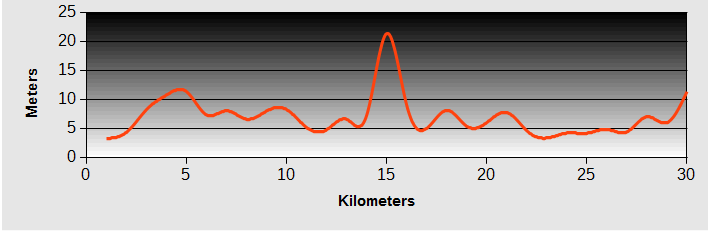
Yeonghae-Busan-Bicycle-Ride : Beolgyo to Suncheon Ride Profile
Ride Description
This was one of those 'at last' days when, after three and a half weeks, everything came together for a perfect day and a discovery of the real Korea. The sun shone from a clear blue sky with just a gentle breeze to tickle the legs.
 Fishing Village
We only had a short ride along the beautiful, flat, peaceful and deserted coastline. Along the way were little fishing villages where life seemed to be little changed over the years.
 The Mud Larks
The tide was out and the locals were out collecting shellfish. For transport they have a 'mud boat', akin to a small sledge,to get around at low tide. Using their feet as propellers they scoot across the sloppy mud.
 Mud Boat
Groups of women packed the shellfish in net sacks and washed them in water tubs on the shore. Their clothes were covered in mud up to their armpits. The shore was alive with tiny crabs and mud-hoppers that scrambled for cover as we rode by.
 Cleaning Shellfish
To complete the perfect morning there was a little cafe with views over the bay serving coffee and cake as well as complimentary local grapes.
 Possibly the best coffee in Korea
Just after this Steve stopped to take a photo of a little old lady, nearly bent double with spinal problems, limping along the road with a bamboo walking pole. Just as he lifted the camera she saw a flock of sparrows feasting on the ripe rice in a field. In an instant she transformed to a screaming banshee, shouting and waving her pole to get rid of the birds scaring him so much he jumped on his bike and rode off quickly.
 The Mild Lady
All too soon we were heading back onto main roads towards Suncheon. A smart new cycle path headed for the river bank but stopped suddenly at a new railway construction and we had to ride along a muddy lane to get back to the route.
Yeonghae-Busan-Bicycle-Ride : Day 14 - Suncheon to Yeosu
- Distance 41km
- Max Elevation 58m
Yeonghae-Busan-Bicycle-Ride : Suncheon to Yeosu Ride Profile
Ride Description
At the riverside on the way out of Suncheon there was an Expo Garden Exhibition and we decided to have a look.
 Suncheon City
Rolling up to the entry gate the security guard came running up waving his arms and insisted we must leave the bikes at the cycle stand in a quiet, unobserved area about 200m back down the road.
 Garden Expo
Steve was adamant he wouldn't leave his bike there and kicked up quite a fuss. By this time we had four officials all gabbling away in Korean and eventually an agreement that we could lock them to the fence next to the security guard.
 Garden Expo
We spent a couple of hours viewing the various gardens. There were crowds of school children there and they had been tasked to ask all foreign visitors they saw for their e-mail address. So we had to spend most of our time writing ours on their forms.
 Email Collectors
The best exhibit was the 'Bridge of Dreams' over the river with a display of thousands of small tiles, each depicting the 'dreams' of Korean schoolchildren.
 Bridge Plaques made by Korean Children
By lunchtime we were back on the river cycle way and ate a picnic watching the shoals of fish in the river avoiding the fishing hooks of the anglers.
 Traditional Costume
 Garden Expo
Heading down the west coast of the peninsula towards Yeosu the minor roads were very quiet, little traffic but even so there was a newly completed cycle track next to the empty road.
Today was the 18th of September and the start of a three day holiday in Korea so we had pre-booked a hotel to make sure we wouldn't have to search around for a room. We had also had two different parcels delivered ready for Steve to replace Karen's Rohloff oil seal.
 The view from our hotel in Yeosu
Yeonghae-Busan-Bicycle-Ride : Day 15 - Yeosu to Busan
Ride Description
We had run out of time and it would have taken at least three more days to cycle to Busan along the coast. So we packed the bikes in their bags and got the hotel to give us a lift in their minibus up to the little bus station. Our destination was Busan Central Bus Station. Throughout Asia the bus stations are always at the furthest outskirts of the cities but this one really took the biscuit. Central it certainly was not.
Without the bikes we could have used the metro but lugging panniers and bikes up and down an escalator and onto the train was out of the question. So we set to to assemble them and ride into town. We attracted quite an audience of interested passengers but we performed well and had everything ready in about 20 minutes. It was a seriously long way into Busan and at one point we climbed up a 15% gradient hill through a golf course! After more than 20km we finally arrived at our accommodation.
Now we had two days to do the sights of Busan and find out about the ferry to Japan.The first morning we caught the metro down to the International Ferry terminal.
 Busan Fish Market
At 11am everything was closed up, the ticket offices not opening until 2pm, so we spent a couple of hours wandering round the vibrant Jagalchi fish market and exploring the unusual merchandise in the Chinese shops.
 Why would you need a bunch of dried lizards
In the afternoon we returned to the ferry terminal and asked for the help of the volunteer translator to buy our tickets, but the lady employee spoke better English than the translator.
 Busan from the Harbour
After a long discussion about the bikes we still weren't clear whether they would accept them for carriage assembled or not. So we decided to pack them in the bags and get a taxi down to the ferry.
With one day left before departure we went to see the United Nation Cemetery where the 2,300 foreign servicemen who lost their lives in the Korean War are buried, a sombre and emotional place.
 UN Cemetery
Finally we had a quick walk along the beach at Haendae before setting off for the ferry.
 Haendae Beach
Link Back to our Tours Page from Yeonghae-Busan-Bicycle-Ride
New! Comments
Have your say about what you just read! Leave me a comment in the box below.