Kyushu-Bicycle-Ride
Fukuoka to Saiki and beyond.
Fukuoka - The Arrival
Our Kyushu-Bicycle-Ride would be our introduction to Japan would be on the Island of Kyushu, the west most major island of Japan.
We were instructed to be at the ferry terminal at 5.30pm to collect our boarding passes and check the bikes. Boarding started at 7pm but the boat didn't actually leave the port until 10pm.
The boat surpassed all our expectations. Other than a large Korean walking group there were just a few other passengers. The cabins were very comfortable. We had bunk beds but there were also Japanese style ones with mats on the floor. Toilets and showers were communal and everywhere was clean and neat.
There was a small restaurant but using it was not as straightforward as it may seem. The menu was displayed outside and available in three alphabets, Japanese, Korean and English. To order food you had to put money into a machine and press the button for the dish you required.
Sounds simple but the buttons only had Japanese and Korean labels. It took us ages to work out which one had the corresponding sequence of squiggles to the chosen dish. Then we had to hand the dispensed tickets to the waitress who delivered our food trays.
By the time we woke the following morning we were already docked at Fukuoka and just had to re-assemble the bikes and ride into the city.
 Arriving in Fukuoka
 Assembling the Bikes
Leaving the gear at the hotel we set off to organise a Japanese SIM card for the phone. Having done this in every other country we have visited we didn't anticipate any problems but eventually gave up and decided to do without Google maps and the tracker for the next four weeks.
 Temple
So we did a bit of sightseeing and fortified ourselves with some Nepalese ten bean curry in tiny little basement restaurant where we were the only customers.
We had read that Japan has a law which bans cyclists from riding on pavements. What we found is that all of the places we visited now have shared use signs for all pavements where it is physically possible to ride a bike. Cycling is very popular here but most people use their bicycles in the towns. The majority have utility type bikes with mud guards, baskets and back racks. There are very few mountain or road bikes.
Schedule
Our ride descriptions give an account of the ride that we completed. As part of the description we also provide links to Wikiloc or Google maps and elevation profiles based on mapping data available through the internet. The ride profiles are smoothed to give what in our opinion is a more beneficial view of the profile. We use paper maps, GPS and on line data to plan and conduct our rides. We are happy for you to use our descriptions, but be aware that we do not guarantee the accuracy of the information provided as situations surrounding any ride change over time.
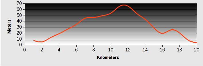
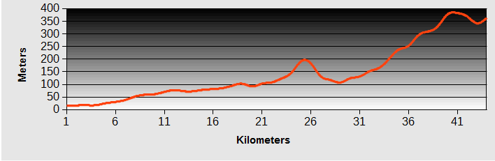
Kyushu-Bicycle-Ride: Day 1 - Fukuoka to Karatsu
- Distance 55km
- Max Elevation 32 m
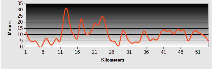
Kyushu-Bicycle-Ride: Fukuoka to Karatsu Ride Profile
Ride Description
Steve had one last try to get a 'pay as you go' SIM on the way through Fukuoka but could only get a six month one which was too expensive. We rode down to the harbour and along a cycle route on the pavement, past the fish market and the Fukuoka tower.
 Fukuoka Tower
Beyond the city there is a long section of elevated highway, with the old 202 road running below it. After a few kilometers the cycle path ends and the road splits into two with a carriageway on each side of the highway. The highway is level but the old road climbs up and down at the side of it and is narrow with no hard shoulder.
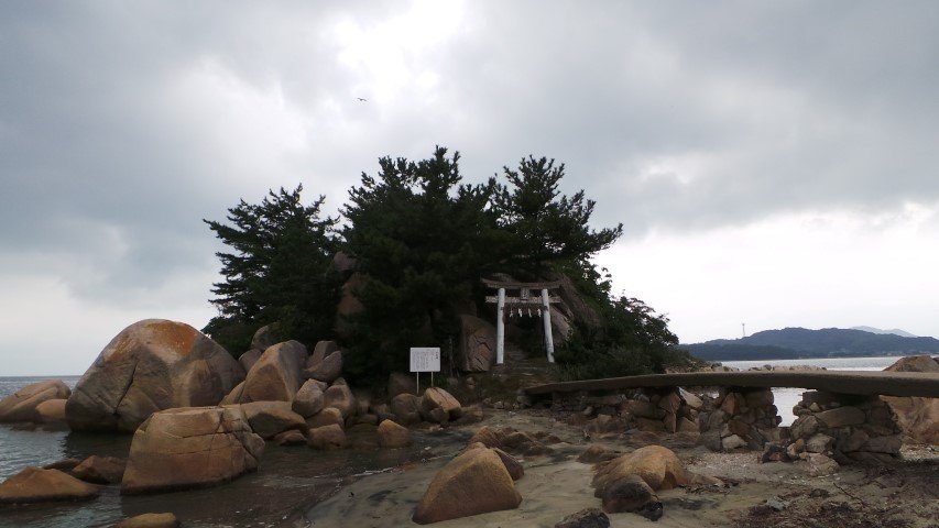
Beyond Itoshima the old road follows the coast along the low rocky cliffs. The bays had narrow yellow sand beaches and the sea was flat. We stopped for a picnic lunch near a rocky islet with a shrine accessed by a narrow concrete bridge.
As we ate and had a paddle the rain swept down the hill at the other side of the bay. We only got a short shower but the higher hills were shrouded in black clouds.
Further along the coast we turned off onto a lovely quiet road through a tall pine forest bordering the beach. The rain caught up with us here so we were glad of the shelter from the trees. We had planned to ride to Yobuko, a little fishing village at the end of the next peninsula but the weather persuaded us to stop at Karatsu.
It was a struggle to find a hotel in Karatsu, we are lost without Google maps. By the time we had found a reasonable motel it was pouring with rain and continued all night. It was so heavy we got a taxi to the nearest restaurant, only 700m down the road.
It was a typical Japanese place with low tables and cushions on the floor. With no wi-fi to use the phone translator app we asked the waitress to recommend something. She returned with two squid, lying on a platter of ice, with part of their flesh removed and cut into thin strips to eat raw. They were still waving their tentacles and looking at us with their huge, accusing eyes. We made a mental note for the future to always make sure the food we ordered was dead.
Kyushu-Bicycle-Ride: Day 2 - Karatsu to Imari
- Distance 69km
- Max Elevation 200m
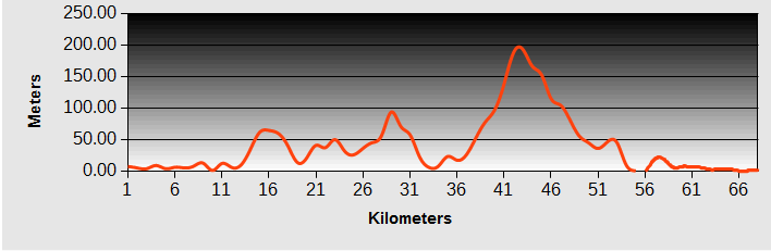
Kyushu-Bicycle-Ride: Karatsu to Imari Ride Profile
Ride Description
The rain had stopped so we decided to continue on the road round the peninsula to see Yobuko. There was a strong north easterly wind as we rode north past rocky cliffs and numerous small rocky islands.
 Coastal views leaving Karatsu
Yubuko was a lovely little fishing village with just enough balance between being a tourist attraction and authenticity.
On this weekday morning there was only one coachload of elderly Japanese tourists. The street was lined with stalls, manned by even older residents...
 Yubuko Fish Market
...selling dried fish, fresh shellfish and sea urchins. In comparison, we were youngsters. One shop owner let us leave the bikes in her garage while we wandered round and had coffee.
 Sea Urchins
Along the northern coast, the road climbed higher to traverse several high bridges over long sea inlets. The harbours here were full of expensive cruising boats, no scruffy, working fishing craft.
 Yubuko Coastal Bridge
Above our heads were flocks of large raptors, black kites, which feed on the fish waste and also are fed with bread by the locals. Being such a windy area there are also many wind turbines.
 Black Kite
It was quite a tiring ride with lots of ups and downs. After passing the Genkai nuclear power plant the traffic increased, and the road climbed a longish hill with narrow lanes, no hard shoulder and lots of heavy lorries.
This section of road is being widened so should be better in future. A man backing his car onto the road gave way for Steve to pass, but did not see Karen. He reversed into the back of her bike, hitting the panniers but causing no permanent damage except to her nerves.
 Yubuko Coastline
Along the west coast there were lots of small villages and farms in the steep sided valleys and terraced fields stretching to the sea.
 Terraced Fields
Imari, famous for its ceramics, is a smart little town with pavements surfaced in gravel and pottery fragments, which glisten in the sun, and bridges decorated with examples of its art.
 Bridge Statue
Kyushu-Bicycle-Ride: Day 3 - Imari to Haika
- Distance 65km
- Max Elevation 68m
Kyushu-Bicycle-Ride: Imari to Haika Ride Profile
Ride Description
Before leaving town we needed cash but struggled to find an international ATM and then it refused to give any cash. Having no SIM we wanted to ring our bank on SKYPE but there was nowhere with Internet open at 9am.
 Okawachiyama Street
The next two hours was spent riding up to the village of Okawachiyama where there were once many kilns producing pottery.There are lots of old kilns here but few actually producing pottery now. We wandered around the steep, narrow pedestrian streets looking at expensive pottery in the shops and the old kilns.
 Terraced Kiln
Returning to Imari was easier, being mostly downhill. We found the only Internet access in town (according to Tourist Information) and managed to contact our bank who assured us there was no problem with our cards. Very few Japanese bank ATM's accept international bank cards. The best option is the Post Office, which has international ATM's in most of its offices.
Once we had plenty of cash we set off south on the 202, following the river valley which is also shared by a small private railway line. We headed for the coast, hoping to find some accommodation there. We passed the Huis Ten Bosch hotel which is a huge European style building, dominating the skyline for miles.
 Huis Ten Bosch Hotel
It was obviously way out of our league so we continued south for about ten more kilometres, but there was just one motel which was closed. Enquiring at the 7/11 we were advised that the nearest hotel was 30km further. So we turned back and returned to Huis Ten Bosch, thinking it was worth asking. Riding over the bridge to the hotel there was loud 'Disney' style music playing over loudspeakers. The large building we could see from the road was only one of several World themed hotels on the site but they are all over 200 pounds a night.
So, in an increasingly bad mood, we rode back to Haiki and found a hotel there, only 35km from Imari, so 30km of wasted energy. Rather than expend more energy searching for a restaurant we decided to eat at the hotel. With low expectations we went into the deserted dining room but the food was actually extremely good.
Kyushu-Bicycle-Ride: Day 4 - Haiki to Nagasaki
- Distance 65km
- Max Elevation 78m
Kyushu-Bicycle-Ride: Haiki to Nagasaki Ride Profile
Ride Description
This morning Steve set off to go for breakfast with his t-shirt inside out, a sure sign of early dementia.
There was 15km of very familiar road to start with, retracing our route back to Huis Ten Bosch. The same loud Disney music was still playing on the loudspeakers.
 Old Bus Cafe
Turning off we headed towards the Expressway, turning off just before the slip road onto a minor road which is signposted as a cycle route to Nagasaki. For the next three kilometers we could enjoy the sunny blue skies and lovely coast views in peace with no traffic.
 Traditional Japanese garden above rice paddy
At least there was one of the millions of drinks machines that line every road in Japan. Even on the most deserted highway, in the smallest village, at the top of a mountain, as long as there is an electricity supply there will be a machine dispensing hot or cold coffee, tea and soft drinks.
We continued south on the 202, following the coast, climbing over a couple of headlands. There was a separate cycle path but it kept changing from one side of the road to the other and varied in quality from rough and narrow to smooth tarmac. It was frustrating because it always seemed to come to an end at a blind bend, meaning a risky crossing of the road.
 Tranquil Omura Bay
Most of the agriculture is rice, with small, terraced fields. With no access possible by machine the harvest is still done by hand, the cut rice suspended on racks to await threshing.
 Racks of Cut Rice
At lunchtime we sat on a little quay with views over the flat calm bay, watching the amazing jelly fish swimming in the shallows.
 Jellyfish
For the last 15km the road went through sprawling urbanisation and shopping malls approaching Nagasaki. It was busy, but had a smooth cycle path. Coming into the city, it was a shock to see the old streetcars (or trams as we know them) still running along the modern, high rise lined streets of Nagasaki. All of the pavements in the city are shared use and plenty of people cycle there, weaving through the crowds of pedestrians.
We called into tourist information at the train station (usually here in Japan) and picked up an English map and booked into a hotel for two nights.
Nagasaki - Day Off
Our hotel was just across the road from Dejima, the old Dutch port that we had read about in the book ' The Thousand Autumns of Jacob de Zoet' . It is being slowly restored to how it looked in the 17th century and was a very interesting place.
 Dejima Museum
No-one could come here without visiting the Atomic Bomb museum and the Ground Zero memorial park. It was a very emotional experience, especially reading some of the personal accounts of the bomb survivors.
 Ground Zero-Nagasaki
One of the abiding memories of all the survivors is the lack of clean drinking water after the bombing and their unquenchable thirst. So the museum and park have many pools and fountains of clean, sparkling water.
 Sufukuji Temple Gate
We enjoyed riding on the old trams and visiting some of the old temples on the hills above the city.
 Spectacles Bridge
On the first night we set out to find a Chinese restaurant recommended in Lonely Planet. Not taking a map with us and trying to find it by memory, we walked into a little local eating place about two doors down from the one we were looking for. It was a lucky find, run by a friendly family, full of locals (it only needed 10 people to fill it) and with wonderful sea-food.
 Nagasaki restaurant owners
The second night we made it to China Town and had another fabulous meal.
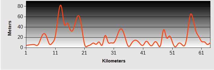
Kyushu-Bicycle-Ride: Day 5 - Nagasaki to Kumamoto
- Distance 80km +ferry
- Max Elevation 138m
Kyushu-Bicycle-Ride: Nagasaki to Kumamoto Ride Profile
Ride Description
We climbed out of the city along a back street running parallel to the 34 on the hillside. There was climb to about 200m but a tunnel at the top saved another 100m of toil. Even better, there was a separate raised pathway to cycle on, and good lighting. By now it was raining and grey so despite the fact we could have seen some lovely views across the sea, we just had clouds.
For lunch we stopped at a 'Farmer's Market' shop which had a help yourself set price buffet. An hour later we found a bakery for coffee and cakes. There was a car ferry from Shimabara to Kumamoto at 3.45pm and we reached the outskirts of the town thinking there was plenty of time to spare. But it was at least 5km further, the rain was pouring and we thought we might miss it. We sped down to the gate, Steve ran across the car park to buy tickets and we were the first passengers to be loaded.
It was a 40 minute ride across a calm sea and then a further 15km to ride into Kumamoto, racing against the setting sun. We knew there were lots of hotels in the city but we couldn't seem to find any of them. At last we found a newish hotel that we could afford that also had a good restaurant.
Kyushu-Bicycle-Ride: Day 6 - Kumamoto to Choyo
- Distance 40km
- Max Elevation 380m
Kyushu-Bicycle-Ride: Kumamoto to Choyo Ride Profile
Ride Description
The breakfast was really good and the sun was shining so today was going to be much better than yesterday. We had booked into a bed and breakfast close to Mount Aso, one of the active volcanoes on Kyushu island. Thinking to avoid the heavier traffic on the main road, we set off up a narrow minor road through the suburbs. It turned out to be a bit of a rat-run, with all the local drivers having the same idea as us.
We dreamt of finding a really good French bakery but had no luck. The road continued up the east side of the river valley, through small agricultural villages, rice fields and bamboo. There were many old wooden barns with earth covered bamboo slat walls, gradually crumbling away.
After 25km the road starts to climb as it comes to the edge of the Aso caldera. There were 500 meters on highway 57 before turning off onto the old 174 which continued to follow the Shirakawa river up a deep gorge. One of the bridges here was being repaired and east bound traffic was diverted onto the busy 57 but there was no-one working today so we rode over the bridge on the other side of the traffic cones.
 Shirakawa Gorge
At Choyo we turned off to the little railway station to get directions to our accommodation. The old station building has been converted into a cafe so we eventually got a cake and coffee and only another 2km to get to our bed and breakfast.
 B and B Cat
Mount Asa - Day Off
We contemplated riding up to the summit of the volcano but, having the World's biggest caldera, it would be a long ride. Instead we did the trip by public transport. The b and b owners gave us a lift to Tatano station as they were going shopping. From there we caught the train to Aso town. The huge flat caldera area has many towns and miles of rice growing in the fertile soils.
 Aso Caldera
From Aso town there is a regular bus up to the volcano. The active crater, Nakadake, and the cable car to it, were closed because of dangerous gas levels.
 Nakadake Crater
Instead we climbed to the peak of Kijimadake, one of the neighbouring summits to get a view of the steaming crater.
 Kijimadake Summit
The walk back down, around one of the inactive craters, through shoulder high grass on a very rough and loose path, was exhausting. The hillsides around the summit of the volcano are used for beef cattle grazing, their smooth grassy slopes contrasting with the forested lower slopes.
 Walking The Crater Rim
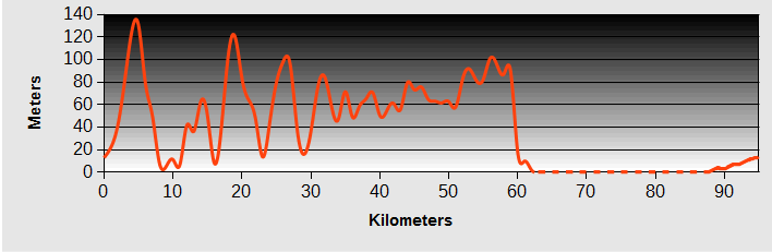
Kyushu-Bicycle-Ride: Day 7 - Choyo to Taketa
- Distance 55 km
- Max Elevation 880m
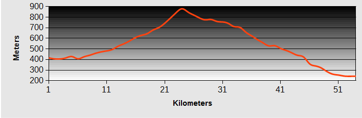
Kyushu-Bicycle-Ride: Choyo to Taketa Ride Profile
Ride Description
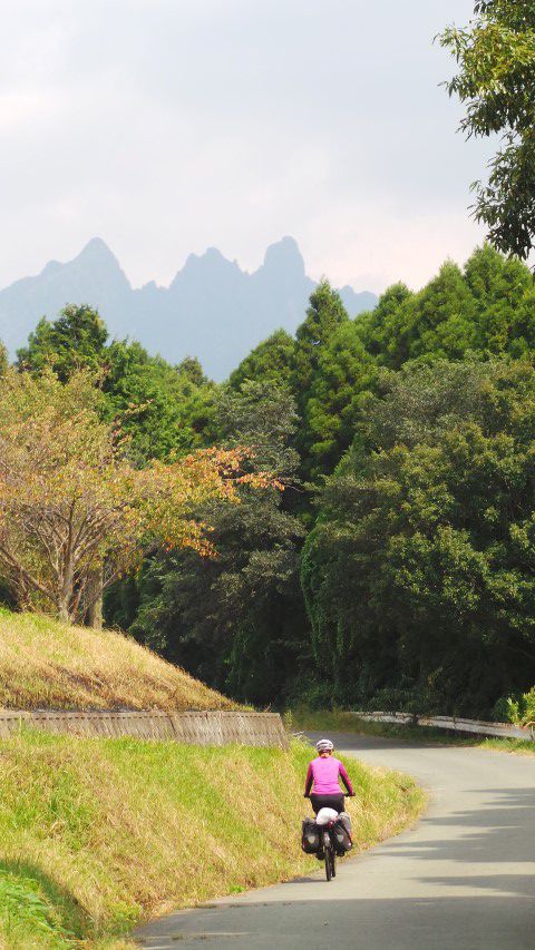
This morning we continued up the Shirakawa valley towards Takamori. On the outskirts of the town we stopped for coffee at a photographer's gallery. He had some amazing pictures of the locality. Close by was the Shirakawa Spring, with gallons of crystal clear spring water bubbling out of a sandy river bed. We drank the water to get energy for our climb back over the side of the caldera.
 Taking the Waters - Shirakawa Spring
A gradual uphill followed, through conifer forests. The evidence of the damage caused by the 2012 floods was everywhere, with huge chunks of concrete torn from the road sides and crash barriers washed away. One of the bridges we had planned to cross had been completely destroyed and we had to make a detour back to a lower bridge.
Having expected a difficult climb it was a shock to realise we were descending again and starting the long downhill to Taketa. We turned onto the 135, a narrow minor road with no traffic on it. Even this top section had not escaped damage and several sections of road edge were completely unsupported above the river valley. After only 5km the damage was more comprehensive and the road closed. We had to make another detour which meant more climbing across four more shallow valleys.
Taketa was a touristy town with a few small hotels, none of which was outstanding. We booked into the nicest one and set off to look for food. Using a map from the hotel we headed down a dark, unlit alley way to find the only restaurant with a western name 'Bistro and Cucina'. The only person there was the chef. He produced an amazing French four course meal for us including boeuf bourguignon, Camembert cheese and chocolate gâteaux......formidable!
Kyushu-Bicycle-Ride: Day 8 - Taketa to Saiki
- Distance 70km
- Max Elevation 250m
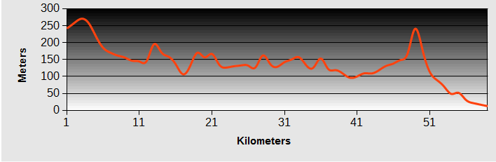
Kyushu-Bicycle-Ride: Taketa to Saiki Ride Profile
Ride Description
Before leaving we had a quick tour of the town including the castle and a pretty temple on a rocky hillside with some interesting stone carvings
 Taketa Temple Statues
 Taketa Temple Carvings
 Taketa Temple Steps
We took a detour to view the Harajiri falls and have a coffee break. There were four tunnels along the way. Only one of them had a separate cycle path. Hara
 Harajiri Falls
Approaching Saiki the traffic numbers increased so we turned onto a cycle path along the banks of the river. It was busy with schoolchildren riding home on their bicycles. The city was one of those places where it is difficult to identify the centre. We rode around a bit and found the railway station with tourist information. No-one spoke English and there was no map with hotels on.
A few streets further was a large modern hotel. The car park was empty and there was no-one around. But the receptionist insisted they were full. So we rode back up the main road to a scruffy tourist hotel that at least had comfortable beds. It wasn't cheap, at 50 pounds a night, not including breakfast and had no wi fi.
But tomorrow was another day and we would catch the ferry to our next Japanese Island Shikoku.
New! Comments
Have your say about what you just read! Leave me a comment in the box below.