Shikoku-Bicycle-Ride
Beautiful coast, valleys, mountains, flora and fauna.
To start our Shikoku-Bicycle-Ride we needed to cross by Ferry from Saiki on the east coast of Kyushu Island to Sukumo on the west coast of Shikoku Island.
It was raining again as we left the hotel and rode down the road to find breakfast and buy food for our boat journey. The ferry terminal was just down the road from where we had stayed and there was no problem getting the tickets. We waited in the shelter of the terminal as the boat arrived and unloaded its vehicles and passengers.
We were boarded first and went upstairs to check out the facilities. That didn't take long as there were none. The only food or drink was from vending machines. There were no seats, just matted floors to sit on and a blanket for cushioning cost 100 yen to hire.
 Seats. What seats?
There were few other passengers so we lay on the floor for most of the three hour crossing. The sea was quite rough with the strong winds so sitting up, on the floor, with no view out of the window was nauseating. From Sukumo port it was a 4km ride into the town with the rain still pouring down. We booked into a hotel on the outskirts of the town centre. It was still raining at 7pm as we walked round the corner to a Chinese for dinner.
 Sailing Japanese Style
Schedule
Our ride descriptions give an account of the ride that we completed. As part of the description we also provide links to Wikiloc or Google maps and elevation profiles based on mapping data available through the internet. The ride profiles are smoothed to give what in our opinion is a more beneficial view of the profile. We use paper maps, GPS and on line data to plan and conduct our rides. We are happy for you to use our descriptions, but be aware that we do not guarantee the accuracy of the information provided as situations surrounding any ride change over time.
Shikoku-Bicycle-Ride: Day 1 - Sukomo to Shimanto
- Distance 85km
- Max Elevation 160m

Shikoku-Bicycle-Ride: Day 1 - Sukomo to Shimanto Ride Profile
Ride Description
Today we planned to ride south, along the coast to Tosashimizu, stay there overnight and then ride around Cape Azihuri, the western of Kyushu's two capes, the next day.
 Sukomo River
Taking the 321 out of Sukumo we went past a couple of little harbours with scruffy village. A 'coffee' sign at the side of the road persuaded us to stop. The place looked fine from the outside.
Inside there was an old lady serving and a couple of locals smoking. The walls and ceiling were coated by a thick layer of black dirt as were the venetian blinds and chairs. On the window ledges were vases that at least had fresh flowers in them but the vases and water in them were revolting. We tried not to touch anything and drank the coffee quickly.
 River Valley on Highway 28
From there we turned off onto the quieter 28 which climbs a small river valley and descends another to rejoin the 321 at the south coast. It was a pretty, peaceful ride along the valley, but as with most river valleys in Japan, most of the banks are concreted and the river flow controlled with concrete barrages.

The south coast was rugged and rocky and we arrived in Tosashimizu about 2.30pm. Searching around the town there seemed to be few restaurants and only a couple of quite scruffy hotels which were not open until 4pm.
 Shikoku South Coast
We didn't want to wait around and then find the rooms unsuitable so decided to carry on north on the 321.
There was a place about 6km up this road, called Kayu Inn, that we had read about in Lonely Planet and we hoped we could stay there. We knew it was quite pricey and was an ecofriendly, organic food place that offered evening meals as well as breakfast. It had a board up advertising rooms available so we stopped.
The owner came out and told us that their policy is not to rent rooms unless they are booked in advance. He asked us if we had read the hotel's 'philosophy' on-line which we obviously had not. He admitted that he had a room available but then looked at the two of us on bikes and pointed out, at least twice, that it was a no-smoking establishment. Then he came up with the deal breaker. Because their meals are organic they needed 24 hours notice to provide an evening meal and the nearest alternative place to eat was 5km away and closed at 5pm.
"Never mind" we said, "we'll just cycle another 25km to Shimanto and find a place that wants our custom". As it would be dark by 5.30pm we now had to pedal as fast as possible on to Shimanto, stopping to put the lights on for the last 5km. The first three hotels there got the thumbs down also but number four was fine, had wifi and also a really good restaurant.
We ate our evening meal while watching the performance of the four staff in the restaurant. There were two chefs, a waitress and a kitchen assistant. They worked together perfectly as a team, needing no verbal communication. Forget the ' Masterchef' scenario with everyone shouting at each other for 'service', these guys produced and served dish after dish of sumptuous food without wasting an ounce of energy talking about it.
Shikoku-Bicycle-Ride: Day 2 - Shimanto to Uwajima
- Distance 68km
- Max Elevation 240m

Shikoku-Bicycle-Ride: Shimanto to Uwajima Ride Profile
Ride Description
Karen woke up this morning with a migraine so had to take pills and stay in bed for another hour. Steve meanwhile went to the lobby to get on the Internet to plan the day's route. It was another grey morning with rain threatening. We decided to follow the Shimanto river valley north for about 50km to Kihoku, which looked like a sizable town where we hoped there would be a hotel.
Leaving Shimanto we followed the 340, a minor road on the east bank of the river. It was another of the roads that had been improved and widened in parts, but then reverted to a narrow winding lane in others.
 Small Land Crab
Traffic was minimal and apart from frequent showers it was a lovely ride. The winding river was fast flowing following all the recent rain and a lot of fishermen were trying their luck.
The valley drains a large area of the mountains and is subject to frequent flooding. Because of this all the bridges across it are 'submersible', with strong supports but no arches or sides so that flood waters can flow over it easily. It's a bit unnerving riding across on a bike though.
 Submersible Bridges in Shimanto
We spent the whole day either putting on, or taking off, rain gear as the heavy showers tortured us. The compensation was that at lunchtime there was a cafe that was open where we had rice rolls, soup and coffee for only 3 pounds each.
There was a hotel in Ekawasaki but we were there just after lunch and wanted to carry on. At Kihoku we started to worry. Although it was a large town the houses were well spread out with no obvious centre.
 An Icon...
A shop owner confirmed our fears that the nearest accommodation was in Uwajima, 15km further and back down to the coast. That 'deja vu' feeling again. So, another small climb to a watershed then a long downhill through a gorge which could have been beautiful in better weather and without dusk rapidly approaching. At least the city had plenty of choice of good hotels and a wide choice of eating. We drowned our sorrows with a bottle of red wine and a rather tasty steak, an extremely expensive (the meal cost the same as the hotel room) but necessary.
Uwajima - Day Off
The weather forecast was for heavy rain all day so we decided to have a day's rest. In fact it was dry most of the day so we walked around the city, visiting its impressive castle, a few temples and the shopping mall.
It was so quiet, with hardly anybody on the streets or in the shops, so different from the Philippines and China.
 Uwajima Castle
Shikoku-Bicycle-Ride: Day 3 - Uwajima to Hosenbo Onsen
- Distance 44km
- Max Elevation 250m

Shikoku-Bicycle-Ride: Uwajima to Hosenbo Onsen Ride Profile
Ride Description
We had to return to Kihoku to pick up our route but decided to take a different road, the 57 which follows the same valley as the railway.
 Old Steam Engine
From Kihoku two roads follow the river valley north, so we chose the 280 which was quieter and wound its way through the small villages with old traditional houses and barns.
 Shimanto Valley
Long flights of stone steps up the hillsides took us to tiny temples and shrines.
We stayed at an 'onsen', the Japanese hot spring. It was our first experience of Onsen etiquette. The baths are separate for male and female. Necessary because no clothes are allowed. First you take a shower, then go sit in one of the hot pools, some have jacuzzis, some are muddy.
Then you go to the washing area which has stools and a hand shower. You sit on the small stool and wash everywhere very thoroughly, shampoo and body wash provided. The locals take ages over this. Once cleansed you get back in the hot water until you can stand it no longer.
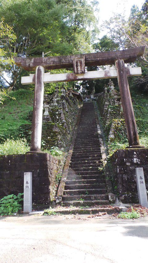
 Typical Small Temple
Accommodation here was good value for Japan and it included access to the hot baths and breakfast. They also had a kitchen which we could use for a small cost, We had brought food with us to cook. The kitchen was fully equipped except there was not a single knife, apparently knives are too risky. Good job we always carry our own.
 Thatched Shrine
Shikoku-Bicycle-Ride: Day 4 - Hosenbo Onsen to Susaki
- Distance 64km
- Max Elevation 700m

Shikoku-Bicycle-Ride: Hosenbo Onsen to Susaki Ride Profile
Ride Description
With a long day ahead we left early. We had to ride 4km back to Shimokagyama where we tried to buy food for lunch but ended up with a couple of apples, some cheese spread triangles and peanuts.
The next 25km was climbing and falling, along river valleys, gradually gaining height following the 197.
There were quite a few lorries and the old road, on the other side of the valley, was appealing. But the new road avoided climbing over the cols and went through tunnels under the peaks.
 Old buildings, not many of them left now
The longest tunnel had roadworks in it, with only one lane open. As always in Japan there were no traffic lights to control the traffic but a man with a red flag for stop and a white flag for go. He waved his white flag and shouted to us to ride fast. Reaching the actual road works, another flag waving guy directed us to the opposite side of the bollards so that the traffic behind us could pass.
 Our Tunnel Guide
He then jumped on a bicycle and rode with us to the end of the tunnel so that he could control the traffic and see us safely back onto the left side carriageway. Amazing service.
 View from the Pass
Finally we reached the top of the last climb, at 500m, and an expansive view over the misty hills towards the sea.
On the steep valley sides were terraced tea plantations with lines of neatly clipped bushes contrasting with the surrounding forest and plunging down into the valley below us.
 Tea terraces
We turned off the main road onto the narrow 133, which hair-pinned down the steep slopes, passing more tea farms and villages with carefully tended market gardens on stone walled terraces.
 Down the Hairpins
Getting closer to the coast the valley flattened and widened and we came to the outskirts of Susaki city, on the south coast of Kyushu.
 Snake on bridge
There followed a very long and tiring search for somewhere to stay. The first hotel we found was large and modern but was fully booked. They pointed us down the road to a second large, older place which also had no vacancies.
 Temple carving
Searching in vain for another hotel or any tourist information we turned in desperation to the local post office as generally the staff there speak a little English.
The guesthouse they suggested was also full but even though the couple who owned it were rushed off their feet trying to prepare evening meals for their guests, they took the time to phone another guesthouse, book us their one remaining room and the daughter got on her bicycle to guide us there.
We had already ridden past this place twice but didn't recognise the sign. The room was a good size, just mats on the floor and 60 pounds a night, no wifi or breakfast. A little Italian restaurant just down the road took the edge off our misery.
 The Guesthouse Sign
Shikoku-Bicycle-Ride: Day 5 - Susaki to Kochi
- Distance 53km
- Max Elevation 150m

Shikoku-Bicycle-Ride: Susaki to Kochi Ride Profile
Ride Description
It was still raining in the morning. In a break between showers we rode to a little French bakery cafe for breakfast. It took two cups of coffee and a big cake before it was fit to set off. We were heading for the 47, which runs through the Yokonami National Park on the coast.
 Boat on the Harbour side
At first the road was busy. There is a lot of industry along this coast with its many harbours. Once we turned onto the 47 it was much quieter. For the first time we passed several 'Henros', the term for the pilgrims who come to Shikoku to walk around the 88 temples close to its coast. Traditionally they wear white clothes and a conical woven sunhat and carry a staff.
 Henro
HenroThe road runs down a rocky peninsula, climbing up and down, affording fabulous views of the Pacific ocean and wave lashed rocks.
 Yokonami Coast
There were few seabirds but plenty of black kites. We watched a man feeding them with bread. He was trying to get them to fly down and pick the bread out of his hand. No wonder the local people are terrified of these birds because they are apt to swoop down and steal food from picnickers hands.
 Feeding the Kites
At the end of the peninsula the road crosses to the mainland over a bridge. The coast here is extensively concreted, with a massive new sea wall, probably as a result of the tsunami, and has lots of small industry.
For the last 10km we rode on the cycle path along the extremely busy 34. The traffic noise was wearing and as we went over an elevated section, an extractor fan on a building sprayed Karen liberally with stinking cooking oil.
Arriving in the city we had to go to five hotels before we found one with a vacancy because, unbeknown to us, there was a national holiday on Monday.
 Sea Wall Sculpture
Kochi - Day Off
Realising it was a national holiday weekend, we suspected the roads and hotels would be busy for the next two days, so stayed in Kochi.. We liked the compact and clean city with its old tram system and pedestrian shopping street.
 Kochi Tram depot
Even better was the choice of food: fish and chips with Guinness at the Irish Bar on Friday, curry and beer at the Indian Saturday and surprisingly good Japanese/French fusion with wine on Sunday. The breakfast at the hotel was less of a treat. Exactly the same poor buffet choice every morning. Hardly any guests in the completely full hotel ate there.
 Sunday Games
We checked out the traditional Sunday market, selling mostly food and vegetable produce to local customers and yet another impressive castle on a hill.
 Chilli Bouquets
Walking around Kochi we were struck by how obedient the Japanese are. At a pedestrian crossing with traffic lights they will always wait patiently for the 'green man' before crossing. Even if the road is clear of traffic in both directions they will never move before the lights change.Car drivers also will never go through lights on red.
 Kochi Bridge
There were small waterways along the roadsides with very clean water, all full of huge, hungry carp.
 Feed Me!!!
Shikoku-Bicycle-Ride: Day 6 - Kochi to Oboke
- Distance 62km
- Max Elevation 400m

Shikoku-Bicycle-Ride: Kochi to Oboke Ride Profile
Ride Description
There wasn't a cloud in the sky this morning. The breakfast room was more popular today with all the tables crowded. A couple from Fukoshima sat with us and chatted to us in English. They were impressed with our chopstick skills.
To get out of the city we had to ride along the busy 374 before turning off onto a minor road to cut across onto highway 32.
 The Three Scholars of Kochi
This road has been widened and straightened in places with a bicycle lane at the side. But once it started to climb into the mountains it was often only two lanes and no hard shoulder. Today was a public holiday so we hoped for light traffic. There were more lorries than we had expected and because of the holiday lots of motorbikes.
After a climb to 400m at Nabiki Pass there is a long slow descent into the Yoshino Valley. The road and railway take opposite sides of the river and there are some long sections of the old road still usable, avoiding three long tunnels and providing an escape from the heavy lorries fora while.
 Yoshino Valley
The river has ultra clear blue water and several narrow gorges and rapids, a white water rafters dream. Steep hillsides are clothed in conifer, broad leaf and palm trees, interspersed with bamboo.
We saw a handful of Japanese cyclists today, mostly on road bikes. With only the single climb it was an easy ride.
 Rafting on the Yoshino River
We had spent a lot of time searching for mid priced accommodation in the Yoshino and Iya valley areas but found that there was little in between the cheap hostels and local guesthouses and the high priced onsens. So we booked into onsens for the next two nights.
The one at Oboke looked a bit shabby on the web photo and as we approached along the road it looked no better. We had low expectations which were proved wrong. Once inside it was wonderful, with friendly staff, beautiful rooms and lovely food. The baths were good too but, as they are separate male and female pools, and neither of us speaks any Japanese, it gets a bit lonely.
 Onsen Hospitality
Shikoku-Bicycle-Ride: Day 7 - Obake to Iyashino Onsen
- Distance 37km
- Max Elevation 800m

Shikoku-Bicycle-Ride: Obake to Iyashino Onsen Ride Profile
Ride Description
The breakfast was impressive, but having a raw egg to drink out of a little cup is not very appetising first thing in the morning.. Grey clouds lined the sky as we loaded the bikes and one of the hotel staff was on duty outside the door to wish all the departing guests goodbye, what a nice touch.
To start the day was a 2km ride back up the valley to the turn off for the 45, which climbs the ridge between the Yoshino and Iya river valleys. Starting the first climb the legs were moaning, despite having been well soaked in the spa yesterday. The road was very quiet, well surfaced and the gradient was never steeper than 10%, Despite the cool morning it was very sweaty.
A family with a small child stopped and stood by the roadside to give us satsumas. The last 100m of climb was saved by the nice tunnel at the peak of the ridge, about 1,500m long. Coming out into the descending valley we started to feel the first drops of rain.
 Iya Gorge
After a 200m descent to the valley floor we turned onto the old 32 road and started another steady climb. Only a few km up the valley is the first major tourist attraction, the Kazurabashi vine bridge at Myoshi.
This is a big coach tour destination but early on a wet Tuesday morning it was quiet. We rode down on the bikes to the newer road bridge from where there is a good view of the vine woven one. At this point the rain got really serious and we had to put on our ponchos.
 Kazurabashi Vine Bridge
The ride up the valley was a long slow, easy climb and the views were beautiful but the rain fell heavily with no respite. There was nowhere to shelter, no bus shelters or rest houses like in Korea. For lunch we had to sit on a log underneath a rocky overhang and were joined by a friendly stick insect.
There were constant jaw dropping views of the river, the bright turquoise waters contrasting with the pale stone cliffs and the autumn tinted trees. Tonight's Onsen was at Iyashino, a steep climb up a side road on the opposite side of the valley. Torrential rain continue until well past bedtime.
We both had a soothing hot bath and then a lovely traditional Japanese meal in the restaurant.
 Iya in the Rain
Iyashino - Day Off
We woke to heavy rain, ate breakfast watching the rain, packed the bags and waited for the predicted break about 10am. It just kept on raining. Climbing 700m in the rain was not appealing so we booked in for another night. Today was Steve's birthday and it was also the day the spa was shut and the restaurant was closed at lunchtime. So he had a birthday feast of a bag of crisps, two cheese spread triangles, a yogurt and a pack of chocolate biscuits. Not even a birthday candle.
Shikoku-Bicycle-Ride: Day 8 - Iyashino to Mima
- Distance 66km
- Max Elevation 64m

Shikoku-Bicycle-Ride: Iyashino to Mima Ride Profile
Ride Description
The morning dawned with blue skies but it was bitterly cold with a northerly wind. We had to put on as many layers of clothes as possible. The short 1.5km descent from the hotel back onto the road froze us to the bone and it was a relief to start the long, gentle 15km climb up into the mountains.
The next village, for some reason, has become famous for its scarecrows and there are some very amusing displays. The two old women chatting over the fence were very realistic, with their wrinkled skin faces and red lipstick.
 Rag Dolls
There was hardly any traffic and the road varied between a narrow,winding one lane to broad, newly surfaced two lanes with a hard shoulder. The narrow sections have electronic warning notices to inform drivers of approaching vehicles.
 More Rag Dolls
Halfway to the top, at Higashi Iya, are two more vine bridges. On this quiet, cold morning we were the only tourists there
 Male Vine Bridge
They cross a beautiful wooded gorge and the trees were glowing with their autumn colours.
The river level was high after all the rain and we couldn't take enough photographs to show the beauty of this place.
 Female Vine Bridge
There is also a reproduction of a wooden cable car river crossing which was lots of fun for two grown up children.
 The Cable Car
The final 7km of climbing was up a deciduous forested valley with the peak of Mount Tsurugi shrouded in cloud. There is a small chair lift from the village at the road junction.
 Forested Upper Slopes of Iya Valley
We put all the layers that we had shed on the climb back on, with woolly hats and gloves and rode up the chair lift. To get to the mountain summit about 150m higher, there was a rough path.
 Mount Tsurugi Chair Lift
It was difficult climbing it with cycling shoes, but seeing some of the extremely elderly and disabled people who had already made the ascent, we had no excuse. Sadly by the time we got to 1,995m the clouds had obliterated the views from the top. There were small drifts of sleet against the path and the temperature was 0 C.
 In the clouds Mount Tsurugi
From the high slopes we could see the 492 road that we were planning to descend on. There was a large landslide and lots of road work vehicles with no other traffic and we realised it must be closed.
 View of the Landslide on Highway 492
Back down in the village we asked the owner of the cafe where we stopped for lunch. He showed us a map and pointed out three roads that were closed following damage in 2012 floods. So there was no choice, the only road down, other than the one we had climbed, was 438.
 View from the chairlift
Ahead was 35km of downhill so all of the extra layers stayed on. Even this was not enough and we had to stop several times to defrost. The road was delightful. Not quite as scenic as the 439 that we had climbed up on as the trees were mostly conifer plantation and obstructed the views. We were held up a couple of times for roadworks but with hardly any traffic it was just a matter of not getting too cold, avoiding the thick conifer deposits on the road and stopping to look at the many beautiful waterfalls tumbling down the rocky cliffs.
The valley was narrow and steep sided all the way until it flows into the broad Yoshino valley. Consequently there is little agriculture.
Reaching Sadamitsu, a sizable town, we enquired about hotels but were sent on to Mima, about 10km further east. It was dusk as we arrived at 5.30pm and it took a while to find accommodation. But the advantage of darkness is that the illuminated hotel signs are easier to see and we found a nice, newish place.
 Old House
Shikoku-Bicycle-Ride: Day 9 - Mima to Tokushima
- Distance 43km
- Max Elevation 122m
Shikoku-Bicycle-Ride: Mima to Tokushima Ride Profile
Ride Description
Today was an easy flat ride down the valley to Tokushima, at the mouth of the Yoshino river. We tried to keep off the busy roads, riding on narrow minor roads through the rice fields. A sign at the roadside pointed us to 'Dochu Sand Pillars" 1km away. Karen was keen to go but Steve got upset about having to climb a 12% hill to get there. It was worth the effort.
 Dochu Sand Pillars
Further down the valley we came to one of the 88 temples on the famous Shikoku pilgrimage and a group of pilgrims walking between temples.
 Kogen-ji Temple
We found Tokushima very like the other Japanese cities we have visited, clean, modern, good shops but somehow lacking soul, with deserted streets and except for a modern shopping mall near the station, we never found its 'heart'.
 Roadside Barn
Shikoku-Bicycle-Ride: Day 10 - Tokushima to Izumisano
Getting to the Honshu ferry was a short easy ride along the riverside road, spoilt by the heavy rain. At the terminal we had just bought our tickets and were sheltering from the deluge near the ticket office when another touring cyclist came to buy a ticket. Bruner is German, of a similar vintage to us and has travelled extensively by bike all over the World. We had an interesting couple of hours sharing stories and information on the ferry.
The ferry was a much more comfortable one than the Kyushu to Shikoku one, with a choice of large comfortable seats, bunk beds and open floor areas for its passengers. On the car deck our bikes were carefully tied in place with cushioning over the handlebars and wedges under the wheels.
At Wakayama we bade Bruner farewell as he set off to catch the train to the airport. We had a 30km ride to Izumisano which is close to Kansai airport.
There shortest route was on the 26, which cuts across the small headland north of Wakayama and then follows the coast north. It had a foot/cycle path for most of its length but some of it was so overgrown and rough that it was safer to be in the traffic. A little minor road along the sea edge for about 6km into Izumisano was the nicest part of the journey.
So there was just a couple of days to rest and pack the bikes before flying back to Manila. Plans for our next adventure, Mayanmar, are almost complete.
New! Comments
Have your say about what you just read! Leave me a comment in the box below.