Cycling New Zealand's Northland -
The Area To The North Of Aukland
Northland is the area to the north of Aukland and was the first part of our New Zealand adventure. The ride took us up the east coat as far as Russel, then across country to the west coast to experience the impressive Kauri forests before heading south back towards Aukland.
Schedule
- Auckland to Helensville
- Helensville to Mangawhai Heads
- Mangawhai Heads to Uretiti
- Uretiti to Mcleod Bay
- Mcleod Bay to Whangerie
- Whangerei to Oakura Bay
- Oakura to Paihia
- Paihia to Kaikohe
- Kaikohe to Opononi
- Opononi to Waipoua Forest Camp Ground
- Waipoua to Baylys Beach
- Baylys Beach to Matakohe
- Matakohe to Brynderwyn (followed by coach to Auckland)
Our ride descriptions give an account of the ride that we completed. As part of the description we also provide links to Wikiloc or Google maps and elevation profiles based on mapping data available through the internet. The ride profiles are smoothed to give what in our opinion is a more beneficial view of the profile. We use paper maps, GPS and on line data to plan and conduct our rides. We are happy for you to use our descriptions, but be aware that we do not guarantee the accuracy of the information provided as situations surrounding any ride change over time.
Northland - Day 1 - Auckland to Helensville
- Distance 49.2km
- Max Elevation 82m

Northland - Auckland to Helensville Ride Profile
Ride Description
The weather forecast for Sunday, the day of our departure from Auckland, was for rain all day. We set off in light rain, but at least as it was a Sunday the traffic was very quiet.
We took Rushton's advice and headed on his route out of Auckland towards highway 16. Nearly all of this was on a separate cycle way next to the highway or on quiet residential streets. There were quite a lot of road cyclists out, all travelling in the opposite direction.

It was a fairly easy exit although we did get our first taste of Northland's hills. As we cleared the suburbs the countryside felt very like Aberdeenshire with beef cattle grazing in rolling pastures interspersed with pine trees, but with arum lilies and tree ferns thrown in. Surprisingly, there were a lot of flat hedgehogs. We weren't sure whether these were an indigenous species or an import. We were also reminded of Scotland when we discovered the favourite New Zealand snack is steak and cheese pie, great when you need a few calories.
The route was fairly flat or small, low gradient hills all the way to Thiensville. It was a strange 'wild west' sort of a place, spread along one main street. In the past it had been a very important transfer point between the railway and the ships that sailed up to Northland before the mainland roads and railway were completed.
Our accommodation was the BBH hostel on the main street. It had been converted from an old cottage hospital and had well appointed double rooms opening onto a verandah with views across to the coast. We were the only residents so it was nice and quiet.
That evening we walked to Porcini's restaurant for a delicious meal of mussels followed by lamb for Steve and duck for Karen. It was the perfect end to our first day's cycling in Northland.
Northland - Day 2 - Helensville to Mangawhai Heads
- Distance 88.5km
- Max Elevation 180m

Northland - Helensville to Mangawhai Heads Ride Profile
Ride Description
It poured with rain all night and we woke to intermittent heavy showers. Our host said that we wouldn't get any further than Wellsford as it was very hilly. This sort of comment always spurs us on to greater things.
After 10km, the serious Northland hills started. They weren't big, only 200m at most, but very steep and there was a strong westerly wind blowing us into the middle of the road all the time. Highway 16 was quiet, although the traffic moved fast. There were no heavy lorries and the camper vans were all small, not like the coach sized ones in California.

Arriving at Wellsford tired and hungry we stopped for coffee and cake. The town was featureless and we really didn't fancy staying there, but asked the waitress about accommodation anyway. As we drank our coffee, Leon, a young cyclist from Northern Ireland came in and chatted with us. He had cycled all the way through the US and was now touring New Zealand. It looked like he hadn't changed his clothes or had his hair cut since setting off. He was on his way to Mangawhai and showed us an easy route through Northland on the map.
Decision made we set off to confound the predictions of our BBH host.
Once off highway one, the Northlandride led us through a scenic valley all the way to the coast at 'Magical Mangawhai'. Mangawhai Heads is another 7km up the coast. After 89km we were pleased to arrive at the Coastal Cow Backpackers Hostel.
This hostel was set up by Tasha and Keroma, but was now being run by Tasha's mum and dad as their daughter and her Kenyan husband have set up an African Safari holidays company. African Touch
Mangawhai Heads is at the mouth of a Northland estuary with large sand dunes between the river and the sea. It makes the bay well sheltered and idyllic with a 'magical' illumination when the sun shines.
Northland - Day 3 - Mangawhai Heads to Uretiti
- Distance 28.3km
- Max Elevation 100m

Northland - Mangawhai Heads to Uretiti Ride Profile
Ride Description
We continued our Northland tour from Mangawhai. We rode north, climbing up a long gorge of traditional New Zealand bush, with tree ferns and conifers. After the long climb we had a fast descent down into Bream Bay which has a stunning beach with golden sand and turquoise sea. We were tempted to swim but there was still a cold wind.
Another climb and descent took us into Waipu Bay and after a further 10km we arrived at the town of Waipu. Here we stopped for lunch and to do some shopping.
We went to visit the Museum that tells of how 900 settlers thrown out of Scotland during the clearances, followed the Rev McLeod first to Nova Scotia, then to Australia, before finally finding their paradise at Waipu. We didn't go in as we are too tight to pay the $8 entrance fee.
After Waipu we joined Highway 1. It was busy and fast with heavy trucks passing frequently. Mostly there was a decent hard shoulder (except for bridge crossings). New Zealand drivers do not like to have to use their brakes unless absolutely necessary and there are frequent road safety signs reminding them to slow down. Unfortunately cyclists are not a reason to slow down.
We stopped at the DOC camp site at Uretiti, which is between the road and the sand dunes with direct access to a beach several kilometers long. We swam and walked on the beach finding lots of shells, the odd dead fish and even a dead baby penguin. Ah!
The only thing that spoilt the whole view was New Zealand's only Oil Refinery, at the north end of the estuary.
Northland - Day 4 - Uretiti to Mcleod Bay
- Distance 55.2km
- Max Elevation 65m

Northland - Uretiti to Mcleod Bay Ride Profile
Ride Description
Although we could see Whangarei just across the estuary from Uretiti it was a 34 kilometer ride along highway 1 to get there. We stopped there for lunch and then headed out towards Whangarei Heads. On the way out of town we took a detour to Abbey Caves. This was a stiff climb of about 500 meters up typically steep NZ inclines. When we arrived a sign warned that thieves operated daily so we were concerned about leaving the bikes.
Luckily the Little Earth Backpacker Hostel was next door and they allowed us to leave our bikes while we went to view the caves. Entry to the caves is free, but to appreciate them you need the proper caving gear. We could only go a few feet into them so couldn't see the stalactites and glow worms. The area around the caves is strewn with volcanic boulders of many unusual shapes. It looked like a Henry Moore exhibition.
Once we had pushed our laden bikes up the drive from the hostel which must have been about 33 degrees, we had a rapid downhill back onto the road to McLeod bay.

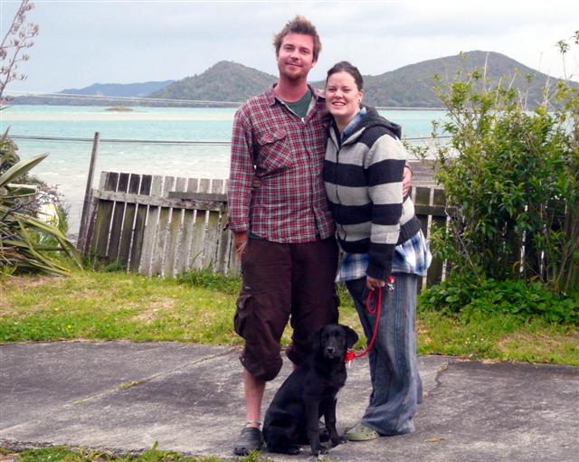
We had arranged to stay with Andy and Charli the son and daughter in law of friends in our home town of Thornton Le Dale. They are renting a lovely house overlooking the sea with towering mountains behind. They had recently acquired a lab cross puppy India, who kept us amused all night.

Northland - Day 5 - Mcleod Bay to Whangerie
- Distance 27km
- Max Elevation 65m

Northland - Mcleod Bay to Whangerie Ride Profile
Ride Description
Charli and Andy, both being keen divers, persuaded us to dive at the Poor Knights Islands, just north of Whangerie. This area is reputed to be one of the most diverse marine sanctuaries in New Zealand. We later understood this to mean "cold water" reserves.
We cycled back into Whangerie and sought out the local dive shop, who suggested that we take a tour with Dive Tutakaka because they would also provide free transport from the town.
The Bunkdown Hostel just outside the town centre would be our base for the next two nights. There was a New Zealand guy in his 70s there, who was cycling from the Bay of Islands, through Northland on a petrol drive assisted bike. There were a lot of young German tourists there too.
The following morning we got up early ready for our pick up at 7-10 am for the 1 hour ride to Tutakana. Everyone at the dive centre was friendly, but we had to get Joe to email our dive logs for verification. Once we were all kitted out and after a quick coffee at the bar, it was all on board.


The boat was pretty fast and it took us approximately an hour to reach the Islands. In the past these islands were inhabited by a Maori tribe. Another tribe on the mainland made overtures to trade, but the islanders sent them packing. So whilst all the island menfolk were away on a hunting trip the mainlanders attacked and massacred all of the women and children that were left on the island. The chief then put a 'tapu' on the island which prevents anyone from living there again.
For our first dive the boat sailed to the northern most tip of the islands. Along the way we saw huge shoals of fish on the surface chasing shrimps. The site known as "Cream Gardens" comprised a wall down to about 20 meters deep, following a spit of land out to sea down to around 80 meters. There were many colourful sponges and nudibranches which required close inspection to really appreciate them. We also saw a seal (briefly), crayfish and scorpion fish. The water surrounding us was littered with long filament type organisms and small gooseberry shaped things like jelly fish, but they weren't jelly fish.
After a prolonged lunch, we moved to the channel between the two islands and dived a site known as Rogers Rocks. This was a shallower dive, to about 17m. The area was gently sloping with large boulders on the bottom. Here there were lots of big snapper, demoiselle, blue fish, black spiny urchins, red moki and black angel fish. After only about 25 mins we were tired and cold so surfaced.
We found cold water diving much more strenuous than tropical diving. Due to the thicker and full wet suits, it was more difficult to control buoyancy. By the time we finally arrived back at our hostel we were so exhausted we bought a take away and were in bed early.
Northland - Day 6 - Whangerei to Oakura Bay
- Distance 49.2km
- Max Elevation 260m

Northland - Whangerei to Oakura Bay Ride Profile
Ride Description
We had a brief conversation with a guy as we were leaving the dive shop and he recommended turning off highway 1, 26km north of Whangerie onto the Old Russell Road and following the highway along the Northland coast.
It was excellent advice. The road was quiet and wound its way along a gently rolling valley before climbing up through bush covered hill sides and then dropping down several valleys with beautifully clear streams. Along this part of the road there were a huge number of dead possums. There is currently an intensive programme in place to try to reduce the numbers of these hugely destructive creatures, introduced from Australia for their fur. We weren't sure whether the ones we saw were poisoned or just run over.
We dropped down to the sea at Oakura, a wonderful sheltered bay with white sand. The campsite was just over a steep bluff, which took some climbing up with the bikes. It was a stand up in the pedals job. It was Labour weekend so the site was busy with families. The weather was warm and we walked along the beach to lay on the sand for the rest of the afternoon.

Northland - Day 7 - Oakura to Paihia
- Distance 49.7km
- Max Elevation 56m

Northland - Oakura to Paihia Ride Profile
Ride Description
The Northland ride continued in much the same vein as the day before, i.e. bush covered hillsides and stunning views over the sea and the bays below. The hills were steep, one after the other as we went from one bay to the next.
Cresting yet another of these hills we met a couple called Oliver and Susan on slick road bikes out for a day's ride. They lived in Auckland but were away for the labour weekend. After chatting with them and watching the dolphins in Elliot's Bay below, they invited us to stay with them if we were passing through Auckland.


There were no shops or cafes along the road and we had no food with us. By the time we eventually arrived in the town of Russell on the Bay of Islands, we were starving and headed straight for a waterfront cafe. This was the first capital of New Zealand before it was moved to Auckland and then Wellington. We thought there would be many more colonial style buildings befitting a capital, but the town centre was rather small and touristy. We were under whelmed.
We took the foot ferry over to Paihia and cycled to the Waitangi Holiday Park camp site. The camping here is at the side of the river and very quiet. We pitched the tent next to a tree with red flowers and enjoyed listening to the serenades from the Tui birds who came to sip the nectar from the flowers. That evening we cycled back into the town, only about 2km, and dined at the Swiss Cafe.
Northland - Day 8 - Paihia to Kaikohe
- Distance 42.2km
- Max Elevation 282m

Northland - Paihia to Kaikohe Ride Profile
Ride Description
Today we would start to cross over Northland from east to west. The camp site was just over the bridge from the treaty grounds where the agreement was signed between the European colonisers and the Maori tribes. Our budget prohibited a visit to the centre itself and we satisfied ourselves with a quick walk around. An old gent suggested that we then take the forest road to Kerikeri to avoid the highway. We took his advice and set off through the hill top golf course, which has to have one of the best golf views in the World, over the Bay of Islands.


The road became an unsealed gravel track and we battled our way along the uneven surface eventually dropping back down into a valley to the Hararu falls.
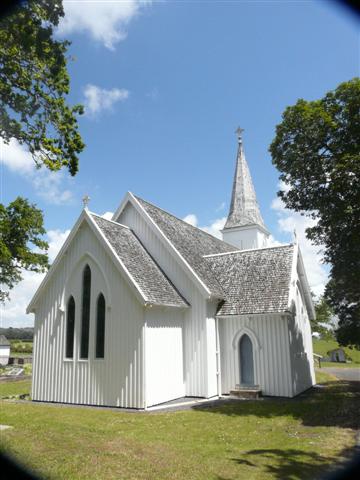
Somehow, having only a crude photocopied map we had taken a wrong turning and come round in a circle, back to the main road that we had been trying to avoid. As it was the traffic wasn't too busy we continued on the smooth road along the valley crossing over highway 12 along quiet back roads. We called in at the Waimate North mission and viewed the quaint old church.
Kaikohe is another non nondescript town spread along the main road. We had planned to camp at the only camp site along that section of highway 12, but it was closed. Instead we checked into a small friendly and quiet motel.
Northland - Day 9 - Kaikohe to Opononi
- Distance 51km
- Max Elevation 210m

Northland - Kaikohe to Opononi Ride Profile
Ride Description
This morning's Northland ride started badly when, just as we were about to set off, we noticed a puncture in Karen's back tyre. Steve installed a new tube and we set off.
The first part of the Northland ride was easy, mostly downhill and straight and we covered nearly 18km in the first hour. As we sped down hill, Karen was hit by an unidentified flying insect which stung her in the abdomen.
Only a couple of miles later her back tyre suddenly lost air. On inspection the inside of the tyre webbing was worn through to the steel and this had punctured the inner tube. We had to patch the tyre and the inner tube to get us under way again.


The Northland ride became more hilly and as we got closer to Hokianga Harbour we crested yet another hill and glimpsed the peak of an unbelievably high sand dune just peeping over the next hill. We could hardly believe our eyes. It wasn't until we dropped down into the harbour that we realised just how big it was. Rising up on the other side of the harbour it must have been 200 m high.
The site at Opononi was only separated by the road from the lovely estuary that formed the harbour.
We brought ice creams for our pudding and put them in the camp kitchen freezer. When we got back there to cook our tea someone had stolen one of them! After dinner, we rode to the viewpoint at the mouth of the harbour to watch the sunset.
Northland - Day 10 - Opononi to Waipoua Forest Camp Ground
- Distance 34.4km
- Max Elevation 400m

Northland - Opononi to Waipoua Forest Camp Ground Ride Profile
Ride Description
The Northland road south out of Opononi is a first gear, lung bursting climb with stupendous views across Hokianga Harbour. An exhilarating long descent follows with rolling hills along the valley all the way to Waimamaku where we stopped for second breakfast.


After that the Northland ride begins a long but fairly gentle climb out of the valley up to the Kauri Forests of Waipoua.
We stopped to walk the forest trails to see these most amazing and ancient trees. The oldest of them are around 2500 years old and at one time the trees covered a large part of New Zealand.
The European settlers felled most of the forests for building, furniture, boats, and other items.

The forests are awe inspiring and it makes one ashamed that European man destroyed in just a few years what took thousands to grow.

Northland - Day 11 - Waipoua to Baylys Beach
- Distance 44.5km
- Max Elevation 3340m

Northland - Waipoua to Baylys Beach Ride Profile
Ride Description
After saying our goodbye's to Alse we set off on our Northland ride with the long climb up the valley and out of the Waipoua Forest. The countryside changed back to rolling hills and meadows and we had a pretty uneventful ride before taking the turn off to Aranga to follow a dirt track for 5 or so kilometres along a rough gravel track down to the beach.


The plan was to cycle along the Ripiro Ocean Beach for 26km to Baylys Beach. This is New Zealand's longest drivable beach. However, by the time we got there the tide was almost fully in and we had to wait five hours before it would be low enough to ride on the compacted sand.
So we ate our lunch and enjoyed a lie on the warm sand watching the Tasman sea rollers breaking on the beach. While Steve guarded the bikes, Karen climbed the 480m to the top of Maunganui Bluff a huge volcanic outcrop rising up from the sea with wonderful views along the Northland coast.


Eventually at 4.30 the sea was low enough to set off and initially it was exhilarating riding on the smooth hard sand with the waves breaking on the right. We were surprised at the amount of dark brown algae in the water which was deposited onto the sand as the tide fell, looking a bit like a huge oil spill. The locals advised us to avoid riding through it as it would stick to our tyres and mudguards and was difficult to wash off.
As we continued we encountered much softer sand that was harder to cycle over and a strong head wind so it was an exhausting ride. A man who was fishing with a set line on the beach gave us two Snapper as they were small ones, they looked huge to us.
The beach is popular with 4 wheel drive enthusiasts. Unfortunately this guy didn't quite make it!
Eventually around 7pm we reached Baylys Bay and had to climb a steep hill up to the camp-site. Our legs were so stiff pushing was the only way to get up. Like a mirage, as we came over the top of the hill there was a bar restaurant called the Funky Fish. We fell through the door and revived ourselves with a pint of the local brew. Invigorated we quickly pitched the tent, put the fish in the fridge for tomorrow and went back to the Funky Fish for a delicious meal.

Northland - Day 12 - Baylys Beach to Matakohe
- Distance 58.6km
- Max Elevation 83m

Northland - Baylys Beach to Matakohe Ride Profile
Ride Description
The thing about New Zealand camp-sites at this time of year is that they are mostly used by foreign tourists on short tours of the islands so everyone is up at the crack of dawn every day. The showers and kitchen are buzzing by 7am. We had to wait for the local shop to open as we had nothing for breakfast so it was a late start.
Dargaville, the first major town, calls itself the kumara (sweet potato) capital of NZ but is otherwise fairly ordinary. We had to find a an internet connection to book our bus for tomorrow so went into the computer shop.
Bus booked we continued, following the Wairo estuary for approx 20 km before turning inland towards Matakohe. We planned to camp at the camp-site which is next to the Kauri museum there. As we got close to the town we saw a camp-site sign directing us to turn right and went off on a roller-coaster ride for about 3km before realising that this was not the right camp-site. It seemed a long 3km back the other way.
Northland - Day 13 - Matakohe to Brynderwyn (followed by coach to Auckland)
- Distance 26 km
- Max Elevation m

Northland - Matakohe to Brynderwyn Ride Profile
We got up early so that we could be packed and ready to go into the museum as soon as it opened at 9am. The Kauri museum tells the story of the first settlers who came to Northland and the industry that grew up around harvesting and using the Kauri trees and also the tree sap or gum. There are a lot of giant cross sections of different trees, including some that were killed in a volcanic eruption and have laid buried in a bog for 40,000 years. There were reconstructions of sawmills and various other machinery and lots of old photographs of different aspects of the Northland logging industry.
About 11am it was time to set off for Brynderwyn to catch the bus to Auckland. The route was as always hilly and still a strong head wind. The 27km to the Swinging Cow Cafe seemed much longer and we only just got there before a heavy shower of rain swept down the valley.
The bus was slightly early and there was no problem getting the bikes in the boot. We had removed the pedals and wrapped the chain in plastic, as instructed on the bus company website, but the driver told us that no-one usually bothers with this.
Two hours later we arrived in Auckland and made our way to Oliver and Susan's place to take up their kind offer of hospitality for a couple of nights.

New! Comments
Have your say about what you just read! Leave me a comment in the box below.