Bike Victoria Following the Wonderful Coast
from Genoa to Melbourne.
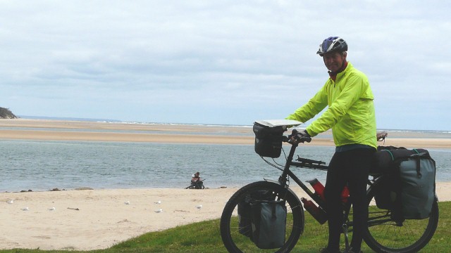
Our Bike Victoria ride followed the coast from Genoa through Lakes Entrance and down to the idyllic Tidal River on Wilson's Promontory. From there we headed west to Philip Island to see the penguins and kola bears, before taking the ferry north and completing our journey into the center of Melbourne. It followed on from our ride from Sydney to Genoa through New South Wales.
Schedule
Our ride descriptions give an account of the ride that we completed. As part of the description we also provide links to Wikiloc or Google maps and elevation profiles based on mapping data available through the internet. The ride profiles are smoothed to give what in our opinion is a more beneficial view of the profile. We use paper maps, GPS and on line data to plan and conduct our rides. We are happy for you to use our descriptions, but be aware that we do not guarantee the accuracy of the information provided as situations surrounding any ride change over time.
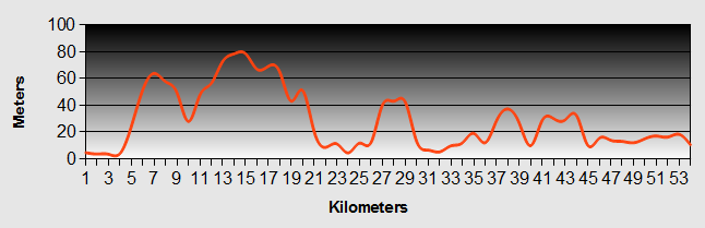
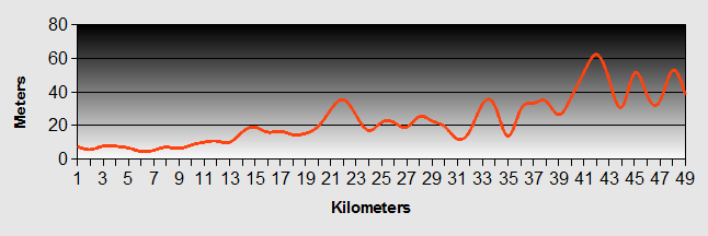
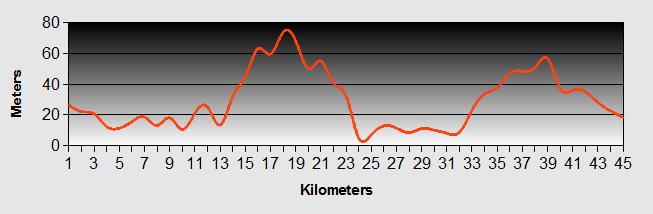
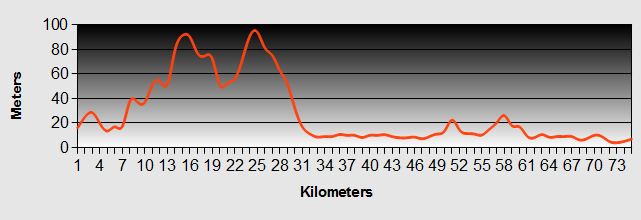
Bike Victoria - Day 1 - Genoa to Cann River
- Distance 48.9km
- Max Elevation 320m
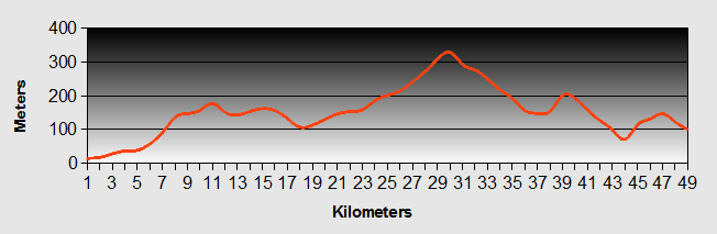
Bike Victoria Genoa to Cann River Ride Profile
Ride Description
Our Bike Victoria ride was the second leg of our journey from Sydney to Melbourne. The morning was cold and showery. The camp site did not have any drinking water but a couple in a camper van filled up our water bottles for us.
The ride started with a long slow climb of 10km again through gum forest with little else to see. We did notice that there was very little road kill here. Presumably in Victoria they remove the corpses, it made cycling up the hill easier without inhaling the stink of rotting flesh.
These long sections of road with little to stimulate the senses lead to some interesting discussions. Today we spent a long time considering the road signs. There are lots along the highway warning of logging trucks. Some of them show a side-on view of a log truck, others have a head-on image. On some the logs are all the same length while others have a pyramid shape. Does the man who makes them get bored with producing the same image or do they mean different things? After doing that subject to death we then spent some time considering what type of creature had produced a particularly large pile of poo on the hard shoulder, concluding that it must be human.
The road continued through the forest, narrow and winding until the descent into Cann River. There was only one food shop and it closed at 1.00pm on Saturday. There wasn't much else there, a few coffee shops, a garage and a hotel. The camp site was the cheapest so far at $10 which compensated for the fact that because the shop was shut we had to go to the hotel for a meal.
Bike Victoria - Day 2 - Cann River to Orbost
- Distance 77.2km
- Max Elevation 330m
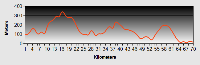
Bike Victoria Cann River to Orbost Ride Profile
Ride Description
The weather was improving at last and the sky was blue. Shopping in Cann River was very expensive, $9 for a loaf of bread. By 9am we were continued our Bike Victoria ride, climbing again for another 10km. The road passed over several divides and dropped down again into valleys so although it felt like climbing a mountain the highest elevation was only 330m.
This was the third day with no towns, services or anything to capture the interest other than miles and miles of gum forest.
Bike Victoria - Day 3 - Orbost to Lakes Entrance
- Distance 56.7km
- Max Elevation 110m
Bike Victoria - Orbost to Lakes Entrance Ride Profile
Ride Description
This morning we hoped to get free internet access at the community centre in town so got up early but then ended up chatting for ages to an Australian cycle tourist from Canberra. He had just completed the Melbourne to Adelaide ride along the Ocean Road and advised that after Port Fairy the route is flat and boring.
There is a rail trail which runs from Orbost to Bairnsdale which seemed a good idea to escape the now busy highway. It was signposted from the road next to the camp site Steve went on ahead but missed a left turn. Karen, having lost sight of him followed the route correctly which meant that as she crossed the Snowy River on the road bridge, Steve was heading off down the river bank in the opposite direction.
Reunited again, we set off on the Bike Victoria trail but found it had a very rough and loose surface and ran parallel to the highway so it was easier to ride on the tarmac. Once again the road rolled through endless gum plantations and with clear blue skies it was very hot. There had been a recent forest fire and we rode for several kilometres through trees with blackened trunks and brown foliage with just a few strands of regrowing bracken to relieve the monotone colour scheme. It was like riding through a sepia photograph.
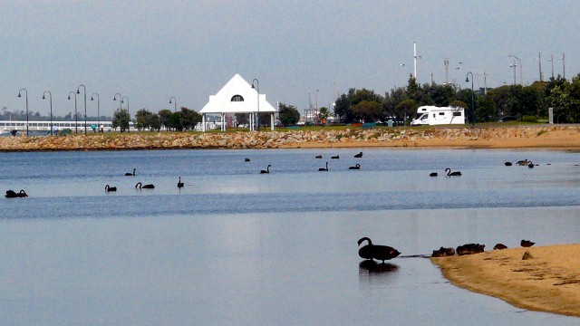
Speeding down the long downhill into Lakes Entrance helped to cool us and we passed a signpost for 'Coulsons Road'. The town was disappointing. The main street running along the lakeside comprised motels and hotels but no bars or cafés with outside seating to enjoy the views over the lake and harbour.
Bike Victoria - Day 4 - Lakes Entrance to Bairnsdale
- Distance 53.9km
- Max Elevation 80m
Bike Victoria - Lakes Entrance to Bairnsdale Ride Profile
Ride Description
The highway out of town was very busy and was narrow as it climbed up the short steep hill out of town. We rode on the footpath on the other side of the crash barrier. At the top of the hill we turned off on a side road towards Metung. It was a quiet road and very hilly but Metung was a beautiful place, on the shore of Bancroft Bay on Lake King. It was obviously a popular retirement town, with lots of new properties being built.
From Metung the Bike Victoria route followed the lovely Tambo river valley up to Swan Reach and back onto the highway. There was a lot of traffic but at least there was a wide hard shoulder. At Nicholson we were able to get back onto the rail trail and escape from the heavy traffic. On this section there was a rough tarmac surface and it ran flat all the way to Bairnsdale.
The campsite had a small swimming pool and it was such a hot day we didn't even bother to pitch the tent before going for a dip. A beer and a meal at the Chinese across the road completed the day.
Bike Victoria - Day 5 - Bairnsdale to Stratford
- Distance 69.8km
- Max Elevation 62m
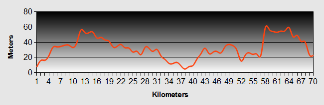
Bike Victoria - Bairnsdale to Stratford Ride Profile
Ride Description
After 5km we turned off the highway onto the C106, a slightly longer but wonderful flat route across grass meadows with grazing cattle and sheep. The ditches at the side of the road were full of frogs that made a noise that sounded like a group of primary school children playing wooden percussion instruments.
As the road was so flat our progress was fast, covering the first 40km in two hours. The Bike Victoria route passed through some lovely old trees and regenerating forest. By 2pm we had reached Stratford which, just like its English counterpart, lies on the Avon River. There the similarities end though. It does have a collection of unique shops which attract the tourists.
The campsite was next to the river but also close to the highway and railway. It was owned by a New Zealand couple so had a really well equipped camp kitchen with a wood burning stove. As we settled down to try and sleep it started to drizzle and there was a lot of noise from the road and railway.
Overnight the drizzle became a downpour and we woke to find the far end of the tent was in a shallow pool of water. The bed mats and sleeping bags were floating on it. There was no way we could move on today. Instead we rented one of the on-site caravans then built a blazing fire in the camp kitchen and spent the day drying out all the wet things.
When the rain at last abated we strolled around the town. The butchers had a 'selection of flavoured snags' which turned out to be sausages so we brought some for tea. The museum was only open on Tuesdays (it was Wednesday), the art gallery was shut and the local film club was showing a film but $15 each was just too expensive.
The most entertaining thing in town was the stories displayed in the Garden for Humanity, just down the road from the camp site One told the story of a local woman, 32, a mother of five children who was driving a group of calves over the bridge when it was washed away in floods. All the calves survived by swimming to safety but she was drowned. Another told of how a travelling circus drove into town under a low bridge and the elephant, which was in an open cart, hit its head on the bridge and died. The carcase was too heavy to be moved and had to be buried right next to the road.
Bike Victoria - Day 6 - Stratford to Seaspray
- Distance 54.6 km
- Max Elevation 82m
Bike Victoria - Stratford to Seaspray Ride Profile
Ride Description
It rained heavily again overnight but we were warm and cosy in our caravan. On the weather forecast the low pressure system which is bringing all the rain is stretching all the way form the north to the south coasts of Australia, difficult to avoid.
Once again we were able to avoid the highway by taking a minor road that ran parallel to it. At the first town, Sale, we stopped to pick up our e-mail and book the ferry to Tasmania at the library.
At Sale the Princes highway turns inland to take a more direct route to Melbourne. For our Bike Victoria ride we turned off onto the Gippsland highway which continues down the coast. A few kilometres further we took the road to Seaspray, a small town right at the end of 90 mile beach which runs all the way from Lakes Entrance.
The approach to the town is through an impressive avenue of ancient pine trees.
Seaspray is very like a some of the small towns on the Lincolnshire coast back inthe UK, full of holiday homes and caravans and little else.
Bike Victoria - Day 7 - Seaspray to Port Albert
- Distance 81.4km
- Max Elevation 53 m
Seaspray to Port Albert Ride Profile
Ride Description
It was a windless morning which was good as there was little shelter on this part of the coast. Once we had climbed up away from the sea the road was flat and we made fast progress on our Bike Victoria ride. There were a lot of big bugs flying around which kept hitting us on our faces and helmets, some quite painfully.
At Darriman we re-joined the Gippsland highway and had completed 60km when we stopped for lunch in the park at Yarram. Here we met two Australian ladies, aunt and niece, who were cycling the Bike Victoria route in reverse traveling from Melbourne to Sydney. It was their first long-distance trip together and they were finding it hard, getting up in the dark at 6am to get packed. We advised them to stay in bed a bit longer.
As we had made such good progress we decided to take a side trip to Port Albert, the oldest port in Victoria which was supposed to have a number of historic buildings. In fact there were only a few and several of these in ruins. We had a beer and some fish and chips, looked around the marina then went back up the road to camp. The camp site was very busy with weekend campers enjoying the warm evening.
Bike Victoria - Day 8 - Port Albert to Foster
- Distance 48.5 km
- Max Elevation 62m
Bike Victoria - Port Albert to Foster Ride Profile
Ride Description
It was a beautiful sunny morning and the people next door woke us up early so we got an early start. Along the Bike Victoria route there were some dubious tourist attractions: an 'historic cemetery' an 'historic pear orchard' and a wind farm viewing platform. Most promising was a large sign offering free hot drinks in 5km. A second one directed us into a picnic area but there were no hot drinks, not even a tap.
By 2pm we arrived at Foster where the camp site was crowded so we pitched the tent on a bit of grass by the side of a caravan awning. We went into the town to shop and met a large group of touring cyclists from Melbourne who stopped to chat about our Bike Victoria ride. It started to rain so we rushed back and dived into the tent and it poured for two and a half hours, a real tropical storm.
Because of the rain everyone was crowded into the campsite kitchen, barbecuing, drinking and chatting so it was a lively evening.
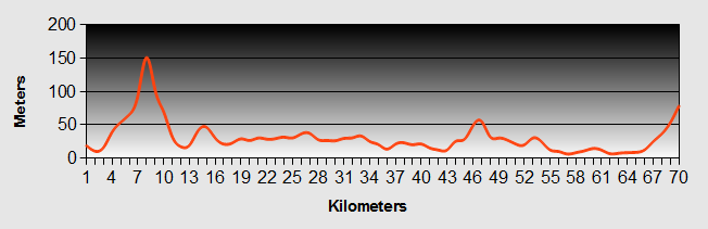
Bike Victoria - Day 9 - Foster to Tidal River
- Distance 59.3km
- Max Elevation 150m
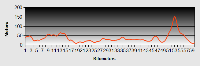
Bike Victoria - Foster to Tidal River Ride Profile
Ride Description
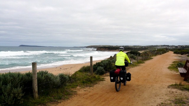
From Foster our Bike Victoria route take another side trip to Wilsons Promontory National Park. Its a very scenic and popular holiday destination for Melbourners. As it was a holiday and the site was fully booked over the weekend, we timed our arrival for Monday afternoon.
We went to tourist information on our way out of Foster and managed to print our route details for Tasmania for free. Again the first part of the Bike Victoria ride that day was along flat roads and we were at Yanakee by coffee time and bacon and egg rolls. Just after Yanakee the road enters the national park and continues for another 20km through gentle rolling hills and low growing scrub. There was a lot of traffic coming in the opposite direction, loaded with camping gear and boats.
The last 10km had three more serious climbs, but the gradients were gentle with fabulous views over the inland forest and over the shoulder, along the coast towards Norman Bay. The hills were topped with huge rounded granite outcrops which looked like big loaves of bread. They were coated with orange and white lichens giving them a candy stripe effect.
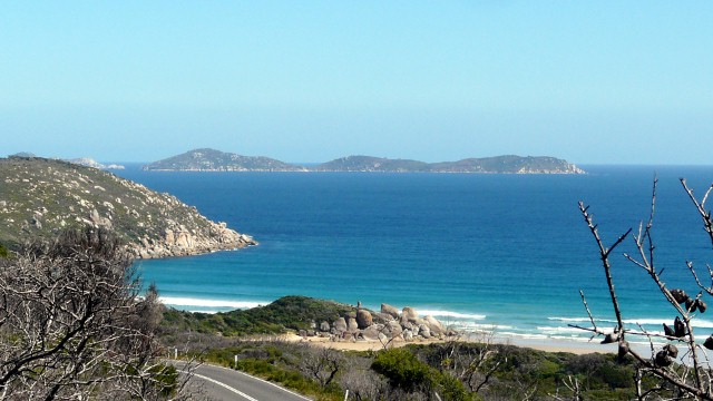
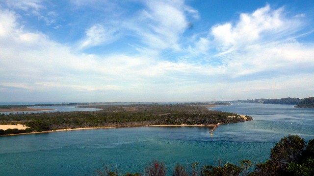
The camp site was large with a shop and take-away outlet. It was formerly used as a commando training camp during WW2. The camp was on the banks of Tidal River and had Mount Oberon as a towering backdrop.
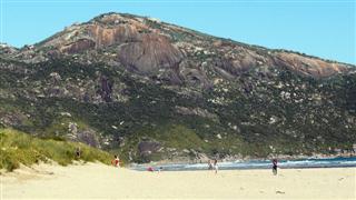
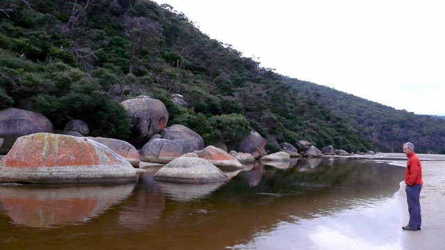
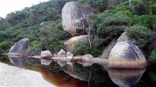
The river meandered towards the sea through a flat, sandy estuary and its banks were strewn with rounded boulders of granite. Oberon Bay had a gently shelving beach and was very sheltered, perfect for swimming.
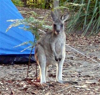
Once it got dark the permanent inhabitants came out to play, wallabies, wombats and possums. There were warnings about wombats ripping open tents to get at food so we slept with ours in the inner tent.
Tuesday we had a day off and just relaxed, swimming, reading and lying around. During the day large groups of school children of all ages began arriving and setting up camp in the large schools section. Apparently there are always lot of school groups here during term weeks. As a treat we thought we would have a take-away for tea but it was closed by 6pm. There wasn't much left in our food stock so we miserably cooked up some pasta and sauce.
Today we heard the news of the devastating earthquake and tsunami in Japan, only a few days ago we had been discussing cycling along this coast as part of our next trip.
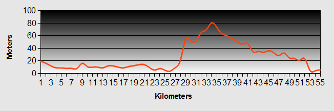
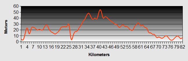
Bike Victoria - Day 10 - Tidal River to Walkerville
- Distance 85.2km
- Max Elevation 150m
Bike Victoria - Tidal River to Walkerville Ride Profile
Ride Description
This morning we were joined by more than a dozen parrots for breakfast, us eating porridge and they feasting of the grass seeds. The first 40km of our Bike Victoria ride today was a back along the road towards Foster. We stopped at the same cafe for second breakfast and chatted to a local grocery sales rep. He told us that it was possible, at low tide, to ride along the beach of Waratah Bay instead of going the longer route by road. This would cut about 7km off our Bike Victoria ride.
We rode down to Waratah bay and onto the beach but about 1 km along the beach stopped at a low rocky platform and even though it was nearly low tide the sea was right up to the rock. This meant turning round and going by the road route. The road skirted around the top of Cape Liptrap National Park, a large tract of native rainforest, one of the best examples we have seen so far in Australia.
There was an enjoyable and speedy descent through the forest to the sea at Walkerville. The camp site was a thin strip of land, between the forest and the sea so that each pitch had a view out to the ocean. We walked along the sand where there were ancient gnarled trees and intriguing animal footprints in the sand.
Bike Victoria - Day 11 - Walkerville to Wanthaggi
- Distance 66.8km
- Max Elevation 154m
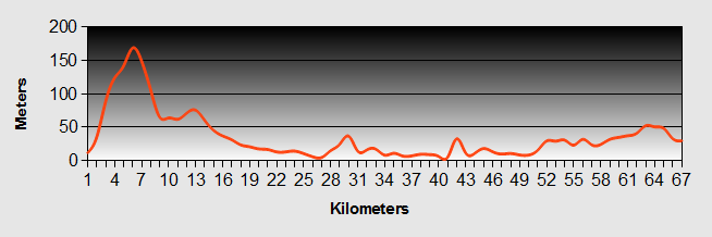
Bike Victoria - Walkerville to Wanthaggi Ride Profile
Ride Description
After yesterday's exhilarating descent, we had to climb back up to the top this morning. The climbing continued to take us over the headland between Walkerville North and Walkerville South. From the top there were wonderful vista across the bay back to Wilsons Prom. The hard climb was followed by a long sweeping descent through fields with huge sand dunes separating us from the sea to the west.
Inverloch was our lunchtime stop. After that our Bike Victoria route took the cycle path along the edge of the beach which looked glorious in the afternoon sunshine.
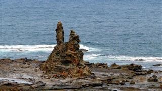
The road climbed to the top of the cliffs on the way to Cape Patterson. There was a wide wave cut platform and this spectacular sea sculpture.
When we arrived at the camp site at Wanthaggi the board said it was full. Over the weekend there was a children’s 24 hour go-cart race and most of the contestants were camping there. As some of them weren't arriving till Saturday there was enough room for us to pitch. The children and parents who were camped next to us were lively and talkative.
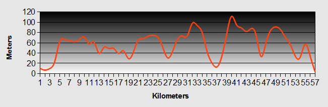
Bike Victoria - Day 12 - Wanthaggi to Cowes
- Distance 45km
- Max Elevation 79m
Bike Victoria - Wanthaggi to Cowes Ride Profile
Ride Description
There was another rail trail running along the coast from Wanthaggi to Anderson so it became part of our Bike Victoria route. This one had a fine gritty surface which was easy to ride on. There was a huge construction project going on at the coast and miles of large diameter water pipes being laid along the side of the trail, we think for a desalination plant.
For about 1 km the Bike Victoria trail ran right next to the sea on the top of a low cliff with the waves breaking just below. It was very popular with sea anglers with their huge rods (no pun intended).
The trail stopped at Anderson and after the quietness of the track we were suddenly on a busy four lane highway with fast moving traffic for 6km to San Remo.
From here there is a bridge over to Phillip Island and a cycle route at the side of the road right across the island to Cowes. The road was busy with traffic and classic cars attending a rally there over the weekend.
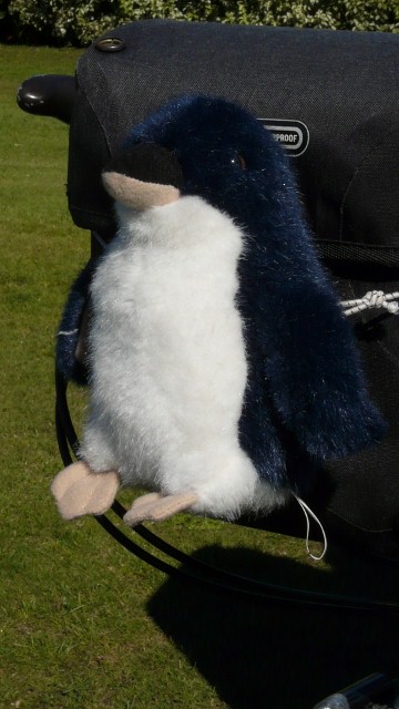
At the Tourist Information office we were unable to resist the little blue penguin looking for a home and christened him Peter. He now takes pride of place on Karen's handlebar bag, come rain or shine.
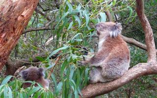
After pitching the tent we rode back to the koala sanctuary. For once we were happy to pay the very modest $10 entry fee and it was worth every penny. As we walked along the board walks through the tree canopy there were koalas sleeping in the trees just above our heads.
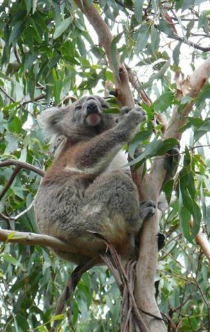
Further on there was a mother and her half grown baby in the tree right next to us.
Bike Victoria - Day 13 - Cowes to Melbourne
- Distance 73km
- Max Elevation 98m
Bike Victoria - Cowes to Melbourne Ride Profile
Ride Description
It was an early start again today so that we would be at the quay in Cowes for the 8.45 passenger ferry to Sandy Point on the Mornington Peninsular. The morning was warm and there were only a few of us up so early on a Saturday.
The boat took about 30 mins, travelling via French Island. Riding up to Hastings the road was fairly quiet. We had planned a route to Frankston, on the other side of the peninsular, from where there our Bike Victoria route could utilise a cycle track all the way up the coast to Melbourne.
To begin with it went well as we safely navigated onto a quiet back road that ran parallel to the busy main road which had no hard shoulder. Then suddenly there was a huge hill ahead and our road went straight up it. So it was back to the main road. There were several sections of cycle track which ran at the side of the railway line but in between we had to brave the busy road with lots of heavy lorries.
At Frankston we had coffee and chatted to a couple slightly younger than us, trying to sell them the idea of selling up and going off travelling. They didn't need much persuading.
From there our Bike Victoria ride follows the coast along the west side. It was a warm sunny day so everyone was out enjoying the weekend. Scantily clad cyclists on their skinny wheeled racing bikes shunned the cycle track and sped past on the road, mums jogged pushing strollers, teenagers on skateboards and families sauntered along creating a nerve racking obstacle course.
From Station Pier there is another cycle track that runs along the side of the tramway all the way to the CBD at Federation Square. The Yarra River bank was even more crowded with lots of cyclists weaving their way through the crowds.
Booking accommodation at the 'Space Hotel' on Russell Street we discovered that Melbourne is hillier than we anticipated! The hotel was very reasonable for a city centre at $89 per room but was in the middle of being refurbished so all the public areas were unusable and the reception was in the middle of a building site.
That evening we went for a meal in China Town, then laid on the comfy bed and watched the TV, a treat after 4 weeks camping.
New! Comments
Have your say about what you just read! Leave me a comment in the box below.