Cycle the East West Highway across the mountains from Kota Bahru to Penang on to Langkawi.
The East West Highway is a great way to cycle from Kota Bahru on the east coast of Malaysia to Pilau Penang in the west. It takes you over the mountains through some more remote areas of Malaysia. If you are lucky you will see Monkeys and Elephant.
Schedule
Our ride descriptions give an account of the ride that we completed. As part of the description we also provide links to Wikiloc or Google maps and elevation profiles based on mapping data available through the internet. The ride profiles are smoothed to give what in our opinion is a more beneficial view of the profile. We use paper maps, GPS and on line data to plan and conduct our rides. We are happy for you to use our descriptions, but be aware that we do not guarantee the accuracy of the information provided as situations surrounding any ride change over time.
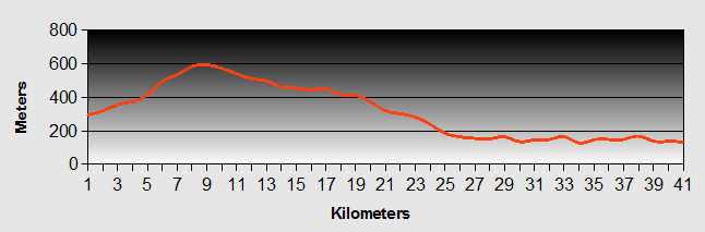
East West Highway - Day 1 - Kota Bahru to Tanah Merah
- Distance 57km
- Max Elevation 28m
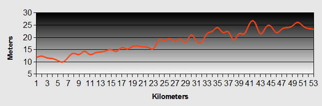
East West Highway - Kota Bahru to Tanah Merah Ride Profile
Ride Description
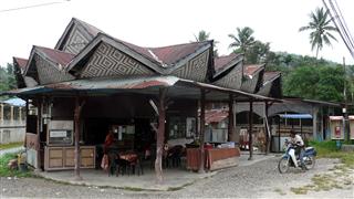
Kota Bahru is one of the most devoutly Muslim cities in Malaysia and we found the constant preaching and chanting, broadcast over loudspeakers in the streets, malls and the market quite intrusive. We were glad to be leaving on our East West Highway ride, but before we checked out of our room we kept up our established tradition of leaving the room in a worse condition than when we had arrived. As Karen bent down packing her bags the mirror which was glued to a dressing table affair, fell forward hitting her on the head. Its a good job her head was there otherwise the mirror would have smashed into thousands of pieces on the tiles instead of just a couple. Still we will have to keep an eye on her for the next 24 hours and make sure she doesn't show any signs of head injury, (flashing lights etc).
At the Royal Thai Consulate, our visas were ready for collection as promised and the route out of town was slightly easier to navigate than the one in, as we took the route north over the bridge and turned onto our East West Highway route following the Sungai Kelantan river inland.
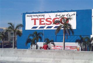
There is a huge amount of road building going on here with new over-passes and bridges being constructed everywhere. There is even a Tesco store right next to the East West Highway.
The East West Highway was much busier than we expected and it was really hot again. The sun hats took a bit of getting used to. They are apt to get whipped off by the backwash from passing lorries so will need a bit of adaptation. Steve is already working on design improvements.
Habitations stretched along most of the East West Highway all the way to Tanah Merah. Our mid morning stop allowed us to sample fresh coconut juice drunk through a straw, straight from the fruit. The afternoon food stall theme was watermelons, great piles of huge ones for miles. Not being able to carry a whole one we stopped and asked a lady if she would just sell us a couple of slices. She cut two huge, sweet ones and then refused to take any payment for them.
Thanks to the sat nav we found a reasonable accommodation with bedroom / bathroom and sitting room for just 13 pounds per night. So by 2-00pm we were checked in and recovering from the heat. Having brought a total sunblock lotion and stopped the anti-malarial tablets our hands were starting to improve.
East West Highway - Day 2 - Tanah Merah to Jeli
- Distance 50.4 km
- Max Elevation 108m
East West Highway - Tanah Merah to Jeli Ride Profile
Ride Description
Today was supposed to be a short ride along the East West Highway, about 45km. Continuing beyond Jeli would mean a further 86km hard ride to the next accommodation at Banding. We set off at 9.00am and rode a few km along the East West Highway before stopping for breakfast at a roadside cafe. It was just across the road from an army base and there were four soldiers there. They didn't speak much English but we managed to have a conversation with them. As usual the first question was "Where are you from?", the second "How old are you?" There are many military bases here, very close to the border with Thailand.
The East West Highway started to climb gently as the morning wore on. There was more forest and less habitation. Being Friday morning there was lots of traffic, mainly local young men in groups on their motorbikes.
After about 42km on the East West Highway we passed the Jelita Inn which we had read about in another cyclist's blog. One of the staff at the hostel in Kota Bahru had recommended the Sri Terapong Inn in Jeli so we continued to try and find it. Nearing the town there was further road building, which confused the sat nav, but after riding round the whole place we assumed it had closed down. So we had to ride back to the Jelita. As there were no rooms with air con there we got a room across the road at the Jeli Inn but the air con in the only available room didn't work. In fact, when Steve investigated further it seemed that it was working in reverse. Ah, the joys of travel.
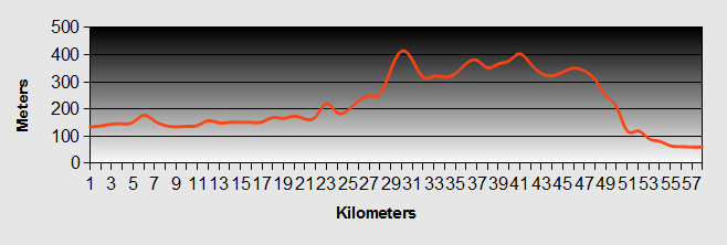
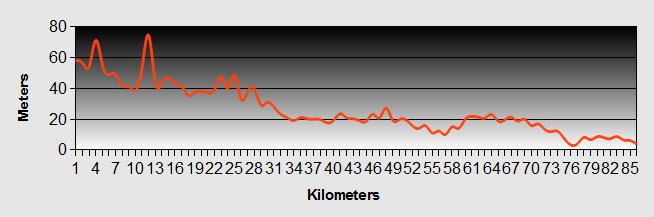
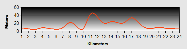
East West Highway - Day 3 - Jeli to Banding
- Distance 82.6 km
- Max Elevation 1057m
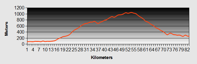
East West Highway - Jeli to Banding Ride Profile
Ride Description
An early start was necessary today for two reasons. First to avoid the heat of the day as much as we could and second to avoid meeting any wild animals up in the mountains. The alarm rang at 6-15am. It was still dark so we dozed for another 15 minutes. We quickly dressed and packed rolling our bikes out into the relative cool of the misty morning.
Retracing our tracks we rode past Jeli and stopped a few kilometres further on for breakfast at a road side stall. This was fast food. Chicken rice, pre packed in grease proof paper paper. It was tasty and we washed it down with mugs of hot tea.
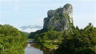
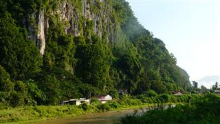
The East West Highway was rolling for about the first twenty kilometres. We passed through Kampung Gungong with its spectacular karst rock towering above the jungle and the river below it.
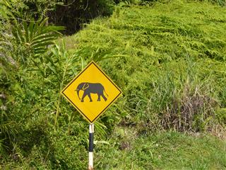
As we started our long climb up the East West Highway, we kept a look out for elephants, but apart from this sign and a few pieces of elephant poo, we didn't see any.
By now the sun was well up. Fortunately there was a fair covering of cloud. Nevertheless, the heat was relentless and we were sweating copiously and drinking similar amounts of water. We finally reached what appeared to be the top of the climb. A sign 3km earlier had announced a rest area and cafe, but when we arrived it was another of Malaysia's great gestures with nothing to back it up and it was closed. We sat and ate dried apricots and nuts and drank more water.
Dejected we continued along the East West Highway onwards through rolling hills. Within minutes we did find a cafe that was open and stopped for our lunch. Feeling refreshed we forged up more hills. We clearly hadn't reached the top. We drank more water, and sweated more tears. After another two hours climbing up the East West Highway we finally reached the top at approximately 1070 meters. There was a cafe and a great view from the top, but the haze made photos not very good. We needed more sustenance so stopped for a bit of Western respite in the form of a beef burger each. If we're not careful we will soon be clucking as our diet currently consists of rice, chicken and eggs. A few people stopped and talked with us about our ride along the East West Highway.
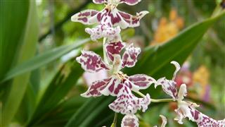
We hoped for a long downhill, but were not optimistic that there would not be more ups and downs. As it was our prayers were answered. The East West Highway swept downhill for almost 30km on a smooth snaking road reaching 50km/h through dense green jungle passing colourful flowers, butterflies and a group of monkeys. The lower we got the higher the temperature and humidity became.
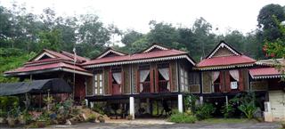
At the bottom was the Temengor hydroelectric reservoir which has the Belum Rainforest Resort on an island in the centre. After sweating up a 1:5 drive to the hotel reception we decided it was beyond our budget with cheapest rooms 338RM a night. On the banks at the other side of the lake was Banding Lakeside Inn, a fairly new, large hotel. This is also built on the top of another steep hill, this time with a 1:4 incline so by now our clothes were floating off our bodies. They had a special offer which meant we only had to pay 130RM for a room with a balcony overlooking the lake and a bath (good for washing the clothes).
After a quick shower it was straight into the infinity swimming pool for a relaxing slow swim then back 'home' to do the washing!
East West Highway - Day 4 - Banding to Gerik
- Distance 39.6 km
- Max Elevation 600 m
East West Highway - Banding to Gerik Ride Profile
Ride Description
A long day on the East West Highway yesterday coupled with a comfy bed meant that we didn't get up until about 7-30am. As we checked out, Steve realised that he couldn't find his cycling glasses. A look in all the bags, around the room and up the steep drive yielded nothing. Neither had they been handed in at reception. Despite one final look around we had to head off without them.
By now it was 9-00am and the sun was well established with only slight cloud cover, not even a breeze to cool us. Turning out of the hotel driveway onto the East West Highway towards Gerik, we were straight away into a long and slow gradual climb for the next 8km. Thankfully there was some shade provided by the trees at the side of the road. Sadly we still didn't see any elephant.
From the top we had a slow descent of the East West Highway for the next 20km and we couldn't believe it could be so easy following yesterday's long downhill. Throughout this time there was not a single roadside food stall, so we had to eat the emergency biscuits with water.
The East West Highway route through the valley was beautiful and when there were no cars around, it was also very peaceful. We had been riding the East West Highway through the rain forest for approximately 100km and are surprised that Lonely Planet makes no mention of this amazing jungle and the reservoir at its centre.
Finally we came into a more inhabited area and found a shack at the roadside with tea and banana fritters. From here it was only another 10km on the East West Highway to Gerik. We had only travelled 42km along the East West Highway, but to go further would have added another 68km through probably hilly terrain, so we decided to call it a day and stay at Gerik. It was clear that we were back in an area of more Chinese population, which meant beer. We found the Avana hotel, which was recommended to us by the nearby Chinese restaurant owner, snoozed for the afternoon and listened to the afternoon thunderstorm.
Later we strolled through town to find some food. Being Sunday evening, all the Chinese restaurants were closed. There was a small food stall that looked popular. As usual they could only offer 'chicken rice' but it was the best fried chicken so far, served with fried chicken blood (a bit like black pudding).
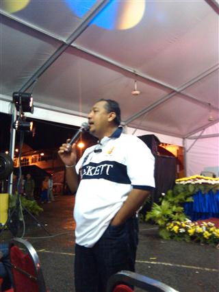
After the meal we went to the supermarket to replenish our food supplies. There was a big marquee on the market place and a lot of people sitting on chairs in front of the stage. Then a car stopped and unloaded a group of very attractive young local girls in traditional costume. There was obviously some event going on so we hung around to see what transpired. A lady persuaded us to take a seat so we went to the back so that, as the only white people there, we wouldn't be conspicuous. The area began to fill with what seemed to be the whole population of the town.
A man who spoke very good English came up to us and insisted we move to the front. He was the local radio presenter who was the MC for the event. His opening introduction involved telling everyone who we were and what we were doing and everyone applauded. After that we watched the girls doing a traditional dance. Then there was a raffle and the final of the local talent contest 'Gerik Idol'. We managed to escape after this to get to bed, ready for an early start tomorrow.
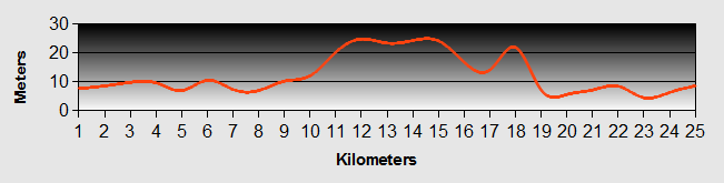
East West Highway - Day 5 - Gerik to Baling
- Distance 57.8km
- Max Elevation 420m
East West Highway - Gerik to Baling Ride Profile
Ride Description
Gerik is a bit like Thornton(-le-)Dale - the spelling keeps changing. On the map it is written 'GRIK' and on some of the road signs, but on others it says 'GERIK'.
The alarm went off at 6.30 and by 7.15, just as it got light we were back on the East West Highway. It had rained overnight and the clouds were still low so the air was fresh and cool. The first 20km along the East West Highway was gently rolling along a forested river valley with many traditional timber stilt houses. One of these was the home of some famous Malayan and we rode up the driveway to get a photo.
Just before the serious climb started we stopped for tea in an attractive road side cafe.
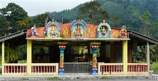
The clouds had now begun to lift and it was warmer. The East West Highway was very quiet with little traffic and delightful scenery. This was the most enjoyable ride so far in Malaysia. Despite this there were constant reminders of how fragile this beauty is. Some of the hillsides were bare due to logging and there were landslips. Other areas had been cleared of the natural rainforest and were planted with young palm trees. There was a massive open-cast tin mine and finally, at the view-point just before Baling we could see the remains of a once massive mountain, now reduced to a few exposed rocky pinnacles, like a rotten tooth. The tin mine was kelian Intan and it was here that we spotted the first Hindu Temple that we had seen in Malaysia.
Baling is a small town by the side of a river which runs against a massive karst rock cliff.
There was a marked difference between this town and those that we had travelled through in the East, with more liberal attitudes and dress due to a larger population of Indians and Chinese. There were not many accommodation options, just a couple of cheap hotels in the centre, so we opted for the slightly better one on the way out of town.
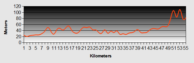
East West Highway - Day 6 - Baling to Georgetown
- Distance 88.6km
- Max Elevation 75m
East West Highway - Baling to Georgetown Ride Profile
Ride Description
Today our ride along the East West Highway would conclude at the east coast harbour city of Butterworth to catch the ferry to Georgetown on the island of Penang. It was a bit of a mystery how far it actually was. The sign on the outskirts of Baling said that the distance along the East West Highway was 96km but the sat nav said 75km. The road numbers on our map were different from those on the road signs. It was also not clear at what point the East West Highway became a Free-way and whether we could ride the bikes on it.
The first 15kms along the East West Highway was through small villages with numerous small roadside stalls selling food and drink. Then suddenly there was nothing except palm plantations, the few roadside vending stalls were all closed down.
We kept following the signs to Butterworth and the E15. Closer to the coast the signs showing the distance to Butterworth had been blanked off. We passed through a huge new town development at Desa and from there the traffic increased dramatically. There were lots of lorries, some carrying nauseating loads of stinking animal carcases and all spewing black diesel fumes over us. The road was narrow and the surface rough and pot holed. We did get onto the E15 after 54km and found that, as we had read, it had a separate motorbike lane but we turned off at the first exit to find a quieter route along the K118 and 119.
It was actually easier than anticipated navigating through Butterworth and to the ferry port.
We had completed our challenging ride across Malaysia's East West Highway.
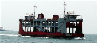
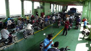
The fare for both of us and the bikes was only 3.60RM (75p) for the five minute ride. Within 5 minutes of arriving here, cycling through Little India, we were in love with Georgetown. Like a miniature version of Singapore but louder, more colourful and more intimate with its fusion of Chinese, Indian, Malay, Japanese, Armenian, Siamese, Burmese and Indonesian culture. Many of the properties are in the old Georgian style, thanks to the time the British were here.
Searching for accommodation took us to Chulia Street to check out the Stardust as recommended by LP. Just behind it was a newly renovated old house called Chulia Heritage Hotel which had a 'petite' room for 85RM a night. Cramped room but queen size comfy bed with crisp white sheets, spotless bathroom, free Wi-Fi and TV. We booked for three nights.
East West Highway - Pulau Penang
Penang Day 1
Known as "the Pearl of the Orient", Penang is the only Malaysian state with an ethnic Chinese majority. Yet, it doesn't feel that way. The island brings together a broad mix of cultures, but mainly those of the Indian sub continent, China and Malaysia, living in harmony, against a backdrop of colonial architecture and with a highly entrepreneurial spirit.
In 1771 the British East India Company signed the first agreement with the Sultan of Kedah giving it the trading rights on the island in exchange for providing military assistance against Siam. Captain Francis Light took possession of the island on behalf of the East India Company in 1786 and the island was formally signed over to him in 1791. He established the island's capital, naming it Georgetown after the Prince of Wales.
By the 1800s the Island was home to over 10,000 people. It thrived thanks to its liberal economy and tax free status, but was supplanted by Singapore, which became the hub of the far east sea trade routes.
It suffered badly through the war years and many of its old buildings were destroyed or damaged. After Malaysia's independence in the 1960s, Penang prospered as a free port, but lost its duty free status to Langkawi in the mid eighties. Despite this there are many high technology businesses based there and some call it the "Silicon Valley of the East".
In 2008 the harbour and old town parts of Penang were awarded World Heritage Status so the old building are being restored and new development more restricted.
Our first day found us sightseeing and following some of the Georgetown Walking Tour outlined in Lonely Planet. After a breakfast of roti canai and sweet tea admiring one of the earliest and simple mosques in the city...
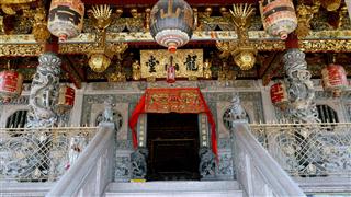
...we walked to the Han Jiang Ancestral Temple.
We had to experience a ride in one of the many trishaws and we agreed a price of RM10 for the ½ kilometre ride to the Penang Museum. When we arrived the "driver" announced that that was the price each. So we coughed up double and felt as though we had been conned, but at only 4 GBP we didn't grouse too much.
The Penang museum is a great place to start as it gives a good background (in English) of the history of the island and Georgetown, and at just 2RM entry fee is good value. Unfortunately you are not allowed to take photographs.
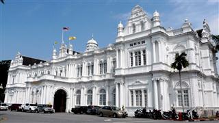
From here it was a 15 minute walk to Fort Cornwallis, passing by the the grand architecture of St. Georges Church, the City Hall and Town Hall which, built in 1800, is one of the oldest buildings in Georgetown.
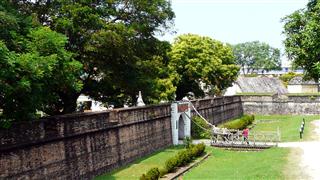
We walked along the sea front and through the Pedang park to the Fort. This is the site of the first stockade built by Captain Light when he started to establish the British presence on Pulau Penang. It was later replaced by a brick built fortification in the shape of a four pointed star with large cannon pointing out to sea. Much conservation work has been undertaken to restore the fort walls, but other than this there is really little left of the original.
Our walk took us through the banking area of the city to the Penang Peranakan Mansion.
Just as we were crossing the road to the Mansion, Karen found a wallet on the road. We did the right thing and walked back to the nearest police station to hand it in.
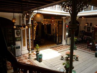
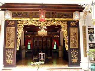
The Peranakan Mansion has been lovingly preserved as a private museum depicting the life of a rich Chinese merchant living in Penang at that time. From the outside the building is in the Colonial style, whilst internally the rooms are sumptuously decorated in the oriental style, with dark wood floors and columns, gilded fret work and carvings. Next door is the old, private Buddhist shrine still largely in its original state.
As we left the Mansion, some locals were chopping up Durian fruit. We had been daring ourselves to try this olfactorially offensive fruit since we had been in Malaysia. Steve took the initiative and tried 'un petit morceau'. Once past the pungent aroma, it was sweet and strongly tasting. Karen declined. Probably a wise decision as Steve said it kept repeating on him all afternoon.
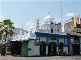
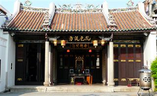
We wound our way through Little India with its incense, colour and noise passing by one of simplest and oldest Mosques e to reach Khoo Kongsi. This is the old Chinese Assembly Hall for the Chinese community in the city.
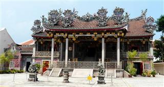
As well as being a benevolent organisation for the members of the Khoo clan it symbolises the strong links between the generations of the clan and the reverence given to their ancestors.
This particular kongsi (clan-house) can trace its linage back through 45 generations to the original founder of the dynasty. Again, oriental architecture and Buddhist symbology abound, and there is a serenity about the place providing an oasis in the middle of the turmoil of the city.
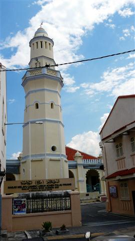
Just along the street we came to the Acheen Street Mosque. In its plainness, a complete contrast to the Kongsi that we had just left. This particular mosque is unusual for its Egyptian style minaret.
By now we were just about dead on our feet, so we retired to the sanctuary of our hotel for a couple of hours before venturing out once more for our evening repast.
Penang Day 2
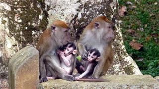
Having "done" the City, we decided today to visit some more of the island and rented a scooter. We fuelled up the scooter on petrol and us on roti canai and headed off to the Botanical Gardens, some 6 or 7 kilometres to the north west of the city. We went with great expectation. Most of the botanical gardens that we have visited in the past had been worth the time and effort. As we parked up, the gardens held great promise. There was no entry fee and we planned a route through the paths up to the "waterfall", (the gardens are also known as The Waterfall Gardens). There were lots of monkeys on route, many with babies, but we kept our distance. The peace of the gardens was shattered by the repeated sounds of automatic gunfire coming from, we assumed, a military firing range nearby.
Reaching the path to the waterfall we were told it was closed and in fact was only open for one day each year! This seemed to set the theme. The cactus house was closed. The fern house was closed for maintenance and the formal gardens? You guessed it, they were closed too. So after an hour traipsing around what was in fact no more than a peaceful park (apart from the gunfire) we hopped back on our trusty Honda and sped off towards the Kek Lok Si Temple. This was easy to find as it was so prominent even from a long way off.
Translated as the "Temple of Supreme Bliss" it is quite startling, if not in scale of ornamentation then in its commercialisation.
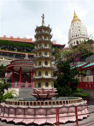
We were reminded of the excessive commercialisation that we observed at Lourdes. Throughout our tour there were opportunities to buy souvenirs.
Statues of the smiling Buddha, wishing ribbons, joss sticks, and other memorabilia. However architecture of the temples and statues is impressive.
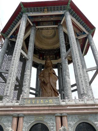
Overlooking the whole site is the massive 36.5meter bronze statue of Kuan Yin, Goddess of Mercy. At the moment a new temple dome is being built over the statue and is near to completion. Unfortunately the scaffolding and building works spoiled the view of the statue.
Our next port of call was the Snake Temple at Beyan Lepas. We followed our sat nav and found ourselves in the midst of an enormous industrial complex, mostly occupied by the huge Braun factory, but also housing other western names like Fairchild Semiconductor. This was the Silicon Valley of the East that we had read about. After chasing our tails for thirty minutes we did find the temple. Negotiating the usual souvenir shops we entered the temple and were underwhelmed by the Wagler's pit vipers lazing, dormant on various tree branches around the alter. These venomous snakes are nocturnal and thus sleep during the day.
Our furthest visit out of the town was to the Penang War Museum. The museum is housed in an old fort on the top of the steep Bukit Batu Maung (hill). Built by the British in the 1930's, it was used as an internment camp by the Japanese during the Second World War. Again this is a private museum and the most expensive we had visited at 35RM each. Was it worth the money? Probably not, but it was interesting nonetheless. There were the remains of the 6" and 15" naval gun emplacements, barracks, stores, etc as well as reconstructions of the gallows used to hang General Yoshimita of the Japanese Imperial Army. The photographs and narratives (in English) told us a lot about a history that we knew nothing of previously.
However, driving around on a scooter in the busy city is exhausting and we now headed back to comfort. That night we ate like kings at the Chinese food stalls down the road from our hotel.
This was our last day in Penang and we had to be up early to catch the ferry to Langkawi, our last destination in Malaysia.
East West Highway - Day 8 - Georgetown to Pantai Cenang, Langkawi
- Distance 23km
- Max Elevation 45m
East West Highway -
Georgetown to Pantai Cenang, Langkawi Ride Profile
Ride Description
Tickets for passengers for the Langkawi ferry are sold at various agencies around Georgetown. The tickets for freight (ie bicycles) are sold at a different office. Luckily we chose an agent close to the freight office and managed to arrange both tickets at the same time.
We arrived at the terminal in good time for our 8.15 departure. It began to fill with passengers for the two ferries. A very officious lady was in charge of directing the customers. She treated everyone like naughty, stupid schoolchildren but in fact that's how they all behaved. Her attempts to separated the passengers for the two ferries, one departing at 8.15, the other at 8.30, were thwarted by impatient travellers who kept trying to get in the wrong queue. We were told that although we had 8.15 ferry tickets we must travel on the 8.30 ferry because of our bikes. This involved a quick run back to the agent to get them to put an official rubber stamp on the ticket which magically allowed us to use it on the other one.
The ferry was full to capacity with a diverse group of passengers. A lot of Malay families, a large group of middle eastern Muslims and a few Europeans.
From the ferry port at Kuah we had a 20km ride to the main beach on the island, Pantai Cenang. This is the busiest resort on the island, popular with backpackers but at least it has 'budget' accommodation even though this is 30% more expensive than on the mainland. As it is officially the rainy season there was plenty of availability but it took a long search on Trip Advisor and Agoda to find anywhere with reasonable customer reviews.
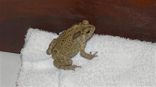
The 'White Lodge' lived up to its good reviews. Set back from the main road it was peaceful and the chalets were well equipped with a fridge, TV and kettle. That evening as we lay on the bed watching TV we discovered an unadvertised amenity, toads under the bed. Over a period of about an hour four of them appeared, hopping for the door which had a large gap under it. Toad
On Saturday we had a day off and sat on the beach, swam and rested. We found the resort was too commercialised for our tastes. The beach was noisy with speed boats, jet skis, banana boat rides and parascending. The resort had a lot of unfinished buildings and lots of rubbish lying around. The only thing that was cheap was alcohol, because there is no tax, but food was much more expensive. It was nice to be able to go into a proper restaurant with a menu and to have food served at the table.
East West Highway - Day 9 - Pantai Cenang to Satun, Thailand
- Distance 35km
- Max Elevation 25m
East West Highway -
Pantai Cenang to Satun, Thailand Ride Profile
Ride Description
Sunday morning we were woken by torrential rain at 7am. By the time the bags were packed it wasn't quite as heavy. Steve tried to put his bike shoes on and found there was no room for his foot. He shook it and out popped another toad. After cycling the 20km to the jetty in the heavy rain we were soaked and had to change into dry things. We brought the tickets, changed some money into Baht then pigged out on cakes and latte coffee at Starbucks. The border formalities seemed very low key and relaxed. A couple of porters hauled the bikes onto the front of the boat and lashed them on with rope. It was a sixty minute ride to Tammalang Pier then a quick 10km ride into Satun still with some drizzle and cloudy skies.
We had been advised to head straight to On's Bar, with English speaking staff and good local knowledge. The Sinkiat Thani Hotel next door is reputably the best in town and our top floor room was pretty basic but had good views over the town to the forested hills beyond. For our evening meal we went next door-but-one to On's restaurant and tried a traditional Thai curry. As it was election day the sale of alcohol had been prohibited but we were allowed to have some amber brew as long as it was disguised in a mug.
New! Comments
Have your say about what you just read! Leave me a comment in the box below.