Cycle the Amazing Whanganui River
and discover its incredible history.
Riding in the shadow of Mount Tongariro to National park and down to Pipiriki on the Whanganui River. We learned the history of the fascinating story around the river and cycled from Pipiriki to Wanganui.
Schedule
Our ride descriptions give an account of the ride that we completed. As part of the description we also provide links to Wikiloc or Google maps and elevation profiles based on mapping data available through the internet. The ride profiles are smoothed to give what in our opinion is a more beneficial view of the profile. We use paper maps, GPS and on line data to plan and conduct our rides. We are happy for you to use our descriptions, but be aware that we do not guarantee the accuracy of the information provided as situations surrounding any ride change over time.
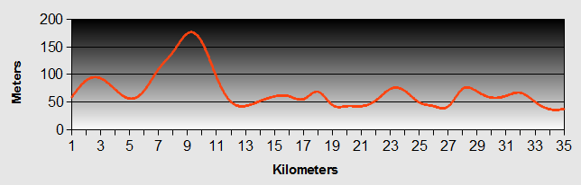
Whanganui River - Day 1 - Turangi to National Park
- Distance 56km
- Max Elevation 950m
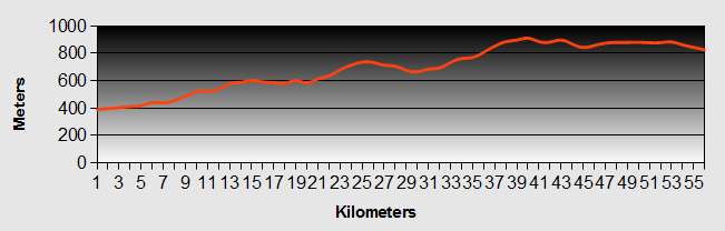
Whanganui River - Turangi to National Park Ride Profile
Ride Description
It had rained heavily all night, but the cloud was higher and it looked as though it was going to be a better day, so we packed up and got under way.
The main route out of Turangi went up the SH47. We decided to take the alternative route down SH 1 for 10km before turning up the SH 47A by the side of Lake Rotoaira, to avoid the steep climb up the Te Ponanga saddle.
It was still overcast with a very strong head/side wind. As we made the gentle climb up SH1we were joined temporarily by a group of road cyclists out practising in preparation for the round Taupo Lake ride. We chatted to them as they were interested in our journey. When we told them of our route down the Whanganui River Road their reply was "Be careful, they still eat people down there!" With that dire warning they sped off ahead as we turned off.
Now the wind was full head on and it was a long slow up hill. The surface of Lake Rotoaira was very choppy and white with surf.
Turning back onto the SH 47 it was disappointing to find that our planned cafe stop was closed so we pulled off the road into bushes to shelter from the wind and eat lunch.
The head wind continued all the way to the summit at 910m, made worse when it also started raining. At one point we took shelter under the trees.
 Mount Ngauruhoe
Although the cloud was very low, we did get some tantalising glimpses of the volcanoes Tongariro, Ngauruhoe and the highest, snow capped Ruapehu at 2797m.
 Mount Ruapehu
Arriving in National Park, we fell into a cafe to warm up. It was a short walk to our hostel, the National Park Backpackers Lodge, complete with very well equipped indoor climbing wall. The place was full, mostly of young gap year travellers, the majority of whom were planning to do the Tongariro Alpine Crossing. During their briefing, which we overheard, they were warned that they may not be able to do the walk as snow and low cloud were forecast.
Like all the other hostels in the area, this one also serves the winter skiing season. At all the ski resorts we have been to previously you see posters warning of avalanche and what to do if you are caught in one. It felt rather strange here to see posters warning of what do in the event of a volcanic eruption.
Whanganui River - Day 2 - National Park to Pipiriki
- Distance 63km
- Max Elevation 820m
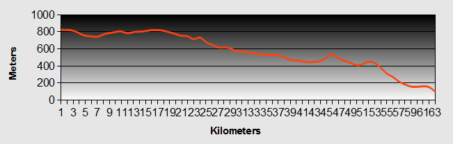
Whanganui River - National Park to Pipiriki Ride Profile
Ride Description
About 6-00am the first group of enthusiastic trekkers woke us as they prepared for their departure. We languished in bed until they had all cleared out of the hostel.
When we went out to get the bikes this morning we could believe that it would be snowing on the mountains. It was freezing, so we donned all of our cold weather gear. It became even more a reality when we saw a snow plough pass us on the road. Again the wind was in our faces, but we were toasty warm and with a fairly easy flat or slightly down hill ride we got well "into the zone", flying along. The only climb of any significance was when we dropped down into the impressive Managanoiuteao River gorge with its perpendicular sides clothed in masses of tropical foliage and spanned by the old iron railway bridge, looking like a childhood Mecano model.
The downhill continued to Raetihi and we completed the last 17km in 40 minutes. Raetihi calls itself a historic town and it has seen its hay day many years ago. Today the majority of shops on the main street are closed up, as is the old cattle market. It had a sad depressed feeling about it.
From here we turned off SH 4 to take the road to Pipiriki and the Whanganui River. On the profile it looked as though the road was mainly downhill, but there were a couple of significant climbs. Once they were out of the way however, the road descended quite steeply following the valley all the way to Pipiriki. In total we had dropped about 800 m from National Park and the increase in temperature was notable.
In the late 1800s the government was trying to encourage people to settle in the area and the Whanganui River was the main form of transport, before the road was finished in 1917. Pipiriki was a thriving village and had a large hotel which served the many tourists and settlers that came up the river by steamboat. Today the village is just a few houses and the gateway into the upper Whanganui River. As such there are three different companies that offer jet boat and canoeing trips in the upper reaches.
We decided to stay for two nights on the free camping area and go for the jet boat ride up the river.
Whanganui River - Day 3 - Whanganui River Canoe Ride
Day Off
The jet boat ride up the river didn't leave until 10-00am, so we could have lazy start. After breakfast we packed our lunch and swimming stuff and took the bikes with our valuables to the Whanganui River Adventures cafe and office.
When we got there, Ken Hawthorn, the owner asked us where the rest of our belongings were and was concerned that we really shouldn't leave them unattended. He loaned us his pick up and we quickly loaded all our stuff and half erected tent into the back to take it up to their place for safe keeping.
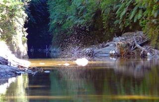
Accompanying us on the trip was a Taiwanese family, mum, dad and two teenage kids, a girl about 20 and a son about 17. We all donned our life jackets and set off in the jet boat for a thrilling 50 minute ride, 32km upstream. Along the way Ken, who was born and bred on the river and whose parents were local farmers, talked to us about the history of the river and stopped at key points to show us interesting features. He pointed out the farm that his parents had owned.
The rock in this area is very soft sandy, almost shale like. As a result the gorge is very deep with near vertical sides covered in lush native vegetation.
 Whanganui River
At various points tributaries enter the Whanganui via equally deep and steep gorges. One of these is the Mangapurua valley. The boat stopped at the Mangapurua landing further upstream where we got off for a 40 minute walk up the gorge to reach the "Bridge to Nowhere".
At the bridge we ate lunch, while Ken showed us a photo history and regaled us with stories of the Bridge, the settlers and the local history. After the First World War, soldiers returning to New Zealand were offered plots of land with incentives to clear them and develop farms. At the time the only access to the land was via the river, requiring a two day boat journey from Wanganui. The plan was to build a road with a bridge of the Mangapurua Valley. There were only four men working on the bridge. Living locally in huts. It took them one and a half years to complete. By this time the onset of the great depression and difficulty in farming the land meant that many of the original settlers had given up and left, leaving only three, who bought out many of those that left.
Over time, the cost of maintaining the road became unsustainable. In addition the new government of the day, that had always been opposed to the project decided to close the valley down and forced out the last few settlers. This was despite them even being prepared to maintain the road themselves. The road fell into disuse and the bridge became overgrown.
Today the bridge has been preserved and the original track has been opened up to walkers and also forms part of the new national cycle way.
To top of the story, Ken showed us a picture of him and his wife Josephine getting married on the bridge several years earlier.
On the return journey Ken dropped us 12km from Pipiriki. Here we changed to canoes and paddled our way down the bottom part of the gorge. There was a strong headwind and apart from four easy rapids that added a bit of excitement, the water was slow moving, making paddling hard. After three hours of paddling, we were relieved that we hadn't signed up for the 5 day canoe trip from Taurmanunui.
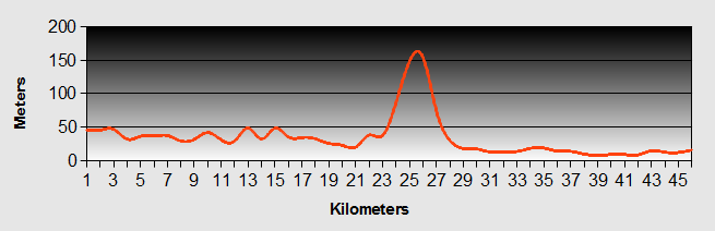
Whanganui River - Day 4 - Pipiriki to Otumaire
- Distance 35km
- Max Elevation 180m
Whanganui River - Pipiriki to Otumaire Ride Profile
Ride Description
The ride out of Pipiriki started on sealed road for about 5km along the Whanganui Valley up and down a fairly easy hill. Then came the gravel section. As we started to ascend the long climb of the day, we negotiated some roadworks that were under way repairing one of the many land slips or washouts as they call them here. The gravel was more like loose rocks and was hard going with our full load, but the hill was gradual and it was a case of just churning away slowly slowly. It was worse coming down the other side as it was loose and it felt like we were riding on a load of marbles.
The gravel ceased momentarily at the small settlement of Jerusalem. It was here that the Sisters of Compassion built their convent and church which still operates today. We walked up for a look and found a peaceful and serene picture. It is possible to stay there and it is used as a retreat.
 Jerusalem Church
It was then back onto gravel road for another few more kilometres before it finally ceased altogether as we came into the settlement of Ranana; or to use its western name of London. Travelling down the valley was a bit like going on a mini World tour, as most of the settlements were originally named after European towns. As well as Jerusalem and London there was Corinth (Korinti) and Atene (Athens).
The rest of the ride was up and down gentle hills. Following the river.
 Jerusalem Church
After Jerusalem, we stopped to look at the only preserved flour mill along the valley, Kawana Mill.
 Kawana Mill
Our camp ground for the night at Otumaire was a free DOC pitch with just toilet and water, by the side of the river. The river wasn't easily accessible as the bank was steep and sandy. The sandy was not firm underfoot and we sank up to our ankles before we found a place firm enough to swim from.
Despite this, the pitch was delightful. We were totally on our own and there was hardly any traffic.
We sat in the evening sun eating our dinner and listening to Queen on our portable music player.
 Kawana Mill
Whanganui - Day 5 - Otumaire to Wanganui
- Distance 46km
- Max Elevation 155m
Whanganui - Otumaire to Wanganui Ride Profile
Ride Description
We didn't want to get up this morning as it was very cold. Being in the bottom of the valley, the sun didn't reach us until about 9-30am. Nonetheless, we ate a meagre breakfast, eating up what was left of our bread and milk (not both together). After the tent had dried off we set off knowing that we had a fairly long and steep climb ahead of us.
We passed through Athens and arrived next at the Settlement of Parakino. We wondered whether it was derived from Paris. It is on the site of a former village called Kaitangata which translated literally as "Cannibal". So the warning that we were given by the cyclist back at Turangi seemed to have a ring of spooky truth about it.
The climb out of the valley was a second gear hairpin of about 2.5km, but the views were worth the ride.
 Whanganui River
As we looked back from the view point at the top of the hill we were surprised to be rewarded with clear view of Mount Ruapehu that had eluded us days before.
 Mount Ruapehu
The descent took us through pine clad hillsides to join the SH4 to Wanganui. We stopped in the lovely little village by the side of the river, Upokongaro which has a church with an unusual three sided spire. It has the strange appearance of looking twisted from whichever angle it is viewed.
It was then an easy more or less flat ride into Wanganui.
Whanganui River - Day 6 - Wanganui
Day Off
Nobody that we spoke with seemed to consider Wanganui as a town worth a visit and it has had a poor reputation for intergang violence and racial problems.
 Wanganui Cinema
However, we found it to be a pretty town (more than many that we had visited in New Zealand) with many of its original buildings still intact.
 Wanganui Colonial Style Buildings
The main shopping area along the tree lined Victoria Street is vibrant during the day with nice pavement cafes and seating areas. It would benefit from being made into a pedestrian precinct though.
 Wanganui Art Deco Architecture
In its early days, the town was a major hub for transport and trade, particularly between Wellington and Hamilton and beyond. Visitors would travel by boat from Wellington and then catch the river steamers up the Whanganui river as far as Taramuni. From there they would take the new train northwards.
 Waimarie River Boat
The Whanganui river is no longer navigable to larger boats, but one paddle steamer, the Waimarie, was salvaged after 47 years at the bottom of the river. Now reconstructed it provides tours up the lower stretches of the river for tourists.
The River Boat Museum at Taupo Quay shows the history, through photos and stories, of life on and around the river, as well as documenting the salvage and restoration of the Waimarie.
Having already taken the tour of the upper parts of the river and the walk to the Bridge to Nowhere, we felt a much greater appreciation of the hardships and struggles of the early settlers that developed the river into a major communication route and set up farms along its banks.
The art gallery stands proudly on a hill to the east of Victoria street and is also worth an hour of your time, with some excellent exhibitions.
 Wanganui Sarjeant Art Gallery
Whilst we were in Wanganui we heard the awful tragic news of the deaths of the 29 miners caught in the underground explosions at the Greymouth coal mine. We were musing about the surreal vision of a Christmas tree in mid summer, but this was tempered by the flags flying at half mast.
 Wanganui Christmas Tree
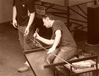
There is a good brochure of the city walk, available from the tourist information i-site on Taupo Quay. The Museum and Art Gallery form part of the walk, as does the Chronicle Glass Gallery where you can see working artists producing the most stunning pieces of blown glass art work.
If you are driving it would be easy to drive through the town and miss what is a much underestimated city. Get out of your car or motorhome and walk around the town. You will be pleasantly surprised.
 Wanganui
Whanganui River - Day 7 - Wellington
Day Off
The roads between Wanganui and Wellington were reputed to be busy through flat boring terrain, so we had decided to take the bus instead. As we boarded the bus we met an American couple of cyclists who were living in Nelson and had just been up around Wanganui for a weeks cycling. They were working as consultants in the wineries having run a vineyard in the Nappa Valley, California.
Our journey passed quickly as we chatted with them, read our magazines and dozed off.
The approach to Wellington was along the oceanside. The road was indeed very busy and we were pleased not to be riding along it. The coach stopped at the train station so it wasy easy to transfer our bikes onto the Metro for the short journey to the suburb of Clifton Downs. It would have been a long steep climb back out of Wellington on the road otherwise.

The party was in full swing as we reached Laura's house, set in the hills above the city. We were welcomed with a cold beer and lots of people to meet. She made us feel right at home. We had a comfy bed and soft towels. We spent the evening chatting, eating and drinking with her friends, finishing off with a dip (kit on) in the hot tub.
The next day gave us the chance to explore the city. Wellington waterfront was a buzz of activity, with cyclists, joggers, roller bladers and tourists. Sightseeing Helicopters were coming and going from the quay. Kayakers were paddling about the harbour dodging the yachts as they raced back and forth.
Our fist visit was to the Te Papa Museum of New Zealand. Entry is free and it was really worth going. In fact there was so much to see and interact with that we couldn't take it all in.
 Te Papa Museum
There was a whole floor dedicated to the natural history of New Zealand. We learned about the history of the Maori and European settlers with accounts of well known New Zealand families and tribes.
We marvelled at the beauty of the greenstone which is greatly treasured by the Maori people. Master craftsmen sculpted the most attractive jewelry and made razor sharp tools for the delicate carving of timber.
What particularly struck us were the personal accounts written by refugees that had come to New Zealand from places like Rwanda, Cambodia, Poland and many other countries. We were both close to tears reading them.
Having only seen the first two floors, we needed a break and headed outside into the Wellington sunshine.
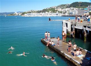
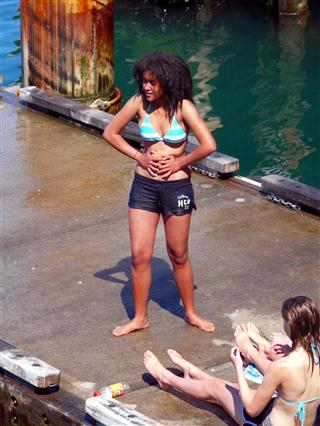
Along the harbour were groups of teenagers swimming and showing off to each other by jumping off the quay into the water some 3 or 4 meters below.
After an icecream stop, we took the cable car up to the botanical gardens and enjoyed the great views across the bay.
 Wellington Cable Car
Later that evening Laura drove us up to the wind turbine view point and around the bays and inlets that make up the Wellington sea front. Then it was time to pack and get ready for the ferry journey to the South Island the following day.
 Wellington
New! Comments
Have your say about what you just read! Leave me a comment in the box below.