Cycling The Top Of The South Island of New Zealand with its Beautiful Bays, Hellish Hills and Friendly Folk
The ride through the Top of The South from Picton to Golden Bay takes in some of New Zealand's most beautiful scenery and coastal walkways. It emcompasses the Marlborough, Nelson, Abel Tasman, Golden Bay, Murchison, Buller Gorge, Hokitika, West Coast, Kaikoura and Hurunui regions.
Our route took us along Queen Charlottes walkway and over the long and steep Takaka hill into Golden Bay and right out to Farewell Spit. It was a time to relax and enjoy the Christmas festivities.
Schedule
Our ride descriptions give an account of the ride that we completed. As part of the description we also provide links to google maps and elevation profiles based on mapping data available through the internet. The ride profiles are smoothed to give what in our opinion is a more beneficial view of the profile. We use paper maps, GPS and on line data to plan and conduct our rides. We are happy for you to use our descriptions, but be aware that we do not guarantee the accuracy of the information provided as situations surrounding any ride change over time.
Top Of The South - Day 1 - Picton
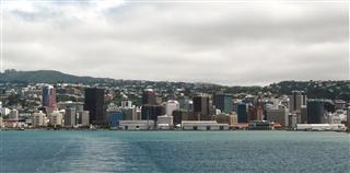
Today, we would cross from the North Island to the Top of the South Island. The ride from Laura's place only took about 30 minutes and was mostly downhill all the way into Wellington centre. After a fruitless half hour trek around the city trying to find the 'Infomap' series 1:500000 maps for the South Island, we were directed to "The Map Shop". It was like an Aladdin's cave of maps and we could have spent ages there looking at the various maps, guides and globes of the countries of the World. We found what we were looking for, but actually opted for the 'Kiwi Map' series instead. It was the same scale, but had more information about tourist attractions, camp sites, etc.
From there it was just across the road to the ferry that would take us to the Top of the South and which left Wellington precisely at 1pm. The sea was calm and the view of the harbour as we left the city was appealing. As there is a speed restriction in the large harbour area, it took us about an hour to reach the Cook Straight i.e.the stretch of water between the North and the top of the South Islands.
On the boat we met Volter and his girlfriend from Germany who were also planning to tour around the Top of The South. He was a touring cyclist, but they had rented a campervan and while he rode his bike, his girlfriend drove the van. He showed us pictures of the Australian coast between Sydney and Melbourne and raved about how beautiful it was, throwing our minds into more confusion about which route to take when we arrived there.
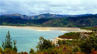
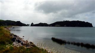
An hour later we cruised into the mouth of Queen Charlotte Sound and the main port entry to the Top of the South. The sight of the bush covered hills around the sounds was tantalising.
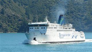
After another hour the ferry arrived at Picton, the gateway to the Top of The South. The town has a marina and lively main street with shops, bars and cafes. There are a number of backpackers hostels and motels.
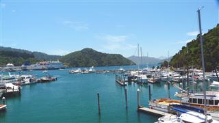
Over the next few days in the Top of the South, it was our plan to walk and ride the famous Queen Charlotte Track, but we needed time to prepare and find out how to get there and back, as the far end is only accessible by water. So we checked in for two nights at the Alexander's Holiday Park. It was at the far side of town, but there was a short-cut footpath along the river. It was also at the side of the railway track. In the middle of the night there were long freight trains running from the harbour which made a tremendous noise.
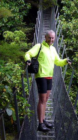
On Tuesday we called in at the Top of the South's Cougar Line company. Their service offered boat transport to the start of the Queen Charlotte Walkway at Ship Cove and a free luggage and bike transfer to your choice of accommodation along the track. The whole 71km of the track can be ridden for most of the year, but from 1st Dec to 31st March cycling is prohibited on the first section from Ship Cove to Punga Cove. We decided to walk this part and cycle the rest.
That afternoon we walked the Picton Snout Track which goes from Picton town to the end of the land spit to the east of Picton. Half way along we stopped for a breather and to swim in the crystal clear waters. At the end of the spit you can look down almost the full length of Queen Charlotte Sound. Erected at the end of the Snout is a moving memorial to two Japanese divers that had drowned there several years earlier.
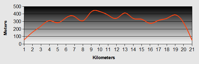
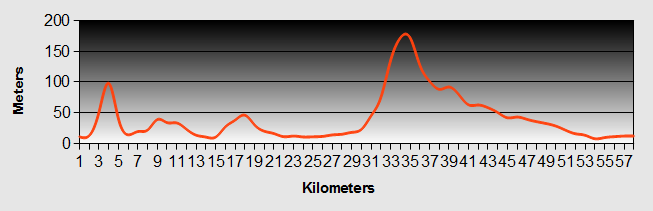
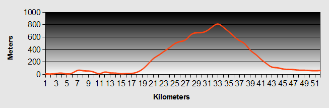
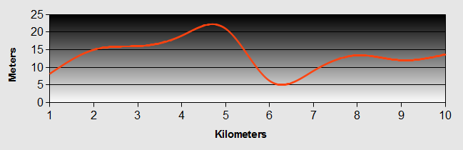
Top Of The South - Day 2 - Ship Cove to Punga Cove
- Distance 13km walk
- Max Elevation 443m
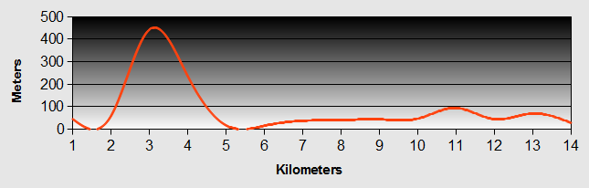
Top of The South - Ship Cove to Punga Cove Ride Profile
Ride Description
It was an early start at 6am, but neither of us got much sleep anyway as a strong wind got up after dark and it rained intermittently all night we were both wondering about delaying our trip for a day as the bad weather was forecast to continue. Three long freight trains rumbling past ensured interrupted slumbers. By the time we rose the rain had stopped but it was still very windy.
Our belongings had to be packed very differently to our normal, well practiced routine. For use on the ride/walk, we only needed a day pack and our lunch. We then had to divide the rest of our gear into two. The things we needed for minimal camping plus food for two nights which would have to be repacked into our holdalls at the taxi quay, and the remainder which would be delivered to the track end point at Atawira. This apparently simple reorganising of our gear was quite stressful and our tempers got a little frayed.
Once at the quay we packed our holdalls, labelled our bags and with only our day packs boarded the water taxi, saying a fond farewell to our precious bikes.
The cruise to Ship Cove took a little under one hour with a slight circle around to spot some rare Hector's Dolphins, but all we got was a glimpse of a dorsal fin.
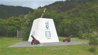
As the taxi left us on the jetty, it felt like we had been abandoned. The only way back now was to walk, but first we visited the Top of the South Memorial to Captain Sir James Cook. Ship Cove was the first place that Cook landed on the top of the South Island. Here his men gathered food and tended the weary with water from the crystal clear stream.
It is also a sacred Maori spot as depicted by the carved totem that we found there.

There were only a few others making the trek, but none the less we didn't want to get caught up with them and quickly headed off on the steep climb, some 200m and taking about 35 minutes. The path winds through native bush. The sun streamed through the tree canopy and a light breeze kept us cool. From time to time we were rewarded with stunning views of the sounds and aquamarine bays below.
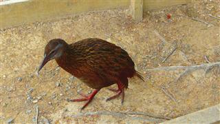
At our first lunch stop we had our introduction to the Weka birds. These are another of the Top of the South's flightless birds, but unlike the Kiwi they are successful and numerous. A group of three of them appeared and stalked around us, fixing us with beady eyed stares. They had huge yellow, eagle like feet and the way they moved and stared at us reminded of the velociraptors in Jurassic Park.
The pathway followed the convoluted Top of the South coast all day, sometimes climbing high and other times dropping back to the coast. Most of the time it wound through the lush bush which gave welcome shade and was full of birdsong and flowers.
Todays walk was 27.5km and we were glad to arrive at our camp site at Camp Bay. We were even more relieved to find our bikes and baggage delivered as promised to the Punga Bay Jetty. Just along the path from the camp was the Punga Bay Resort which had a bar and cafe at the sea edge where we enjoyed a cold pint of beer, returning later for a fish and chip supper.
The resort was manned by a multinational staff some of whom we met that evening. Also there was a young, long blond haired Austrian lad who was chatting up the bar staff and trying to scrounge somewhere to sleep for the night. During the conversation it transpired that he played the accordion which was in his van that he had left at the Portage Hotel further along the track. He also told us that he had the full lederhosen uniform to go with it, even though it was a bit tight as it had been bought for him when much younger. The pretty and vivacious Harriet behind the bar was getting quite hot under the collar at the thought of him in his tight leather shorts. Unfortunately we didn't get a chance to see him perform - on his accordion that is.
After dinner the chef wandered down the jetty with a bowl full of fries and started to feed the fish. There were hundres of herring and spotty fish boiling at the surface. We also saw mink fish, eels and star fish.
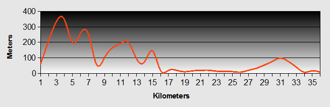
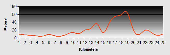
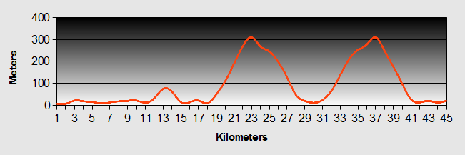
Top of the South - Day 3 - Punga Cove to Cowshed Bay
- Distance 20km offroad
- Max Elevation 470m
Top of the South - Punga Cove to Cowshed Bay Ride Profile
Ride Description
We were woken early again, but this time by the dawn chorus which was cacophonous and then by the Weta birds which had found their way under the edge of the tent and were breakfasting on our fruit.
As we prepared breakfast we realized that we had left behind our knife, fork and spoon sets so we had to eat our muesli with a large plastic serving spoon and a spatula.
With our gear packed, we carted our holdalls back to the jetty and left them in the small hut ready for pick up.
It was great to be doing some off road, none load cycling at last. We were confronted initially with a steep push up the hill at the back of the camp ground before briefly coming onto a gravel road and then cutting back onto the track again. The climb continued, alternating between pushing and riding. Fortunately the day was overcast and refreshingly cooler. None the less after a 430m climb we were sweating like pigs. To offset the long climb we had the excitement of some challenging down hill sections over rocky and loose surfaces.
Overlooking the Sound, we ate our lunch with a young guy from Somerset who despite the offer of free baggage transfer included in his ferry ticket had opted to carry it all himself. He was young, strong and carefree. He reminded us of our eldest son, Simon. Spontaneously while he was in Christchurch, he decided to run 10 kilometers in his bare feet. This resulted in him getting blisters. Undeterred he went and scrounged some merino wool from a store to dress his wounds and was now walking the Queen Charlotte Track in three days. Normally it is done in four. Ah the benefit of youth!
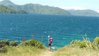
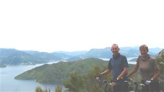
 View from Queen Charlotte Track
 Descending Queen Charlotte Track
The final descent to our next stop over was long and exhilarating, the last kilometer being on sealed surface. Two pints of Tui had our name written on them and we sat on the plush 'Portage Resort' terrace looking out across Kenepuru Sound. Refreshed, we picked up our bags which were stored securely by the hotel ($12 for this privilege) and cycled 300m to our pitch at Cow Shed Bay.
The site was next to the water and was occupied by about thirty noisy teenage girls and their teachers. Fortunately there was another part of the ground on the other side of road and nearer to the toilets. We pitched the tent and went for a swim in the cooling sea.
Back at the tent a bearded guy rolled up on a bike. He was planning to spend the night at his friends house just up the road and had just stopped for water. He stayed for another 15 minutes coming out with weak jokes and meaningless banter. We were pleased when he headed off.
That night we ate a delicious steak at the Portage Hotel.
Top of the South - Day 4 - Cowshed Bay to Havelock
- Distance 35km 50% off road
- Max Elevation 370m
Top of the South - Cowshed Bay to Havelock Ride Profile
Ride Description
As we ate our breakfast we were joined by our friend from the evening before. It turned out that his friend wasn't in and he had therefore spent the night on his deck. He again stayed talking for another 20 minutes while we were trying to pack our gear. He tried to frighten us with stories of steep hills to climb, dangerous precipices and rock falls on the next section of the track. He suggested we take the sealed road instead. We took it all with a pinch of salt and were again glad to see the back of him.
The ride started with a four hundred meter climb, the first hundred meters on the road. Turning off onto the track it was steep and rocky. It was only possible to push and we were thankful that we did not have our gear with us. The sun was fierce and the sweat dripped off us in buckets.
Finally we reached the top. The views to the sounds were breathtaking. The water was flat calm with interference patterns caused by the bow waves of passing vessels.
For the first two hours we didn't see another soul and could career down the track at full tilt. It was an up and down roller coaster ride before the second major climb of another 200m.
From Mistletoe Bay, the track became much easier with gentle rolling curves following the contours along the coast, through dappled beech tree forest along rocky pathways.
By now we were passing groups of walkers that had set off earlier in the day and we exchanged gentle banter. Us threatening to run them over and they returning with threat to poke their sticks through our wheels; all in the best possible humour. All too soon we were in Anakiwa. It was only 2pm and we had to wait until 3-30 for the taxi to arrive with our bags. We sat and watched an outbound school learning how to row, kayak and sail. It caused some amusement and the time passed quickly.
The Queen Charlotte Track was thoroughly enjoyable, both as a walk and as a cycle ride. We would highly recommend it.
The boat arrived at 3-30pm. Our gear was offloaded and we had to then re pack it into our panniers before we could set off again to complete the final road section to our next stop, Havelock.
The road around the Top of The SOuth is pretty well flat all the way to Mounui on the Pelorus Sound. It then rose gradually to a view point overlooking the estuary, across to Havelock. After that came a long and enjoyable descent all the way to the town. We pulled up outside the Havelock Hotel. Although it was only five o clock, it was heaving with people, mostly men and many still in their work clothes, wellingtons, shorts and t shirts. The local mussel factory, the biggest local employer, had just undergone a big refurbishment and this was the celebration of its completion. At the bar we were offered the chance of rolling the dice to win our drinks for free, an different slant on 'happy hour'. We won one and lost one.
The campsite was just down the road from the hotel and next to the marina. We checked in for two nights as we needed to wash ourselves and our belongings of the accumulated dust from three days on the track.
That night we ate at the restaurant that overlooks the slipway at the marina, watching people launch their boats ready for a weekend on the water. The range of abilities and styles was vast and we were kept amused all evening.
The following day was spent doing all of our chores, emailing, blogging and speaking to family on Skype. At 5pm we went back to the same marina bar for 'happy hour' and this time watched people returning with their boats. Getting them onto the trailers required even more skill than launching them and some people needed a bit more practice, one missed the trailer altogether.
Top of the South - Day 5 - Havelock to Nelson
- Distance 76km
- Max Elevation 395m
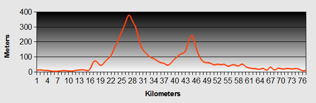
Top of the South - Havelock to Nelson Ride Profile
Ride Description
The Peddler's Paradise warned us of the hills we had to climb today. The couple that we had met previously, Karen and Henry had also said that it was quite narrow and busy.
As it was Sunday there were few trucks and the traffic was generally lighter. The first 25km was virtually flat terrain until we reached Pelarus Bridge. We stopped at the cafe and paid $18 for two lousy pies and a pot of tea.
It was very hot as we started the first climb to the Rai Saddle at 247 metres. It was a gradual 2/3 gear incline all the way with good width hard shoulders for most of it. We descended through pine forests and stopped at a picnic spot next to the river to eat lunch. As we were leaving the lay-by, we met an American couple cycling in the opposite direction and chatted with them for a few minutes.
The second climb of the day was longer up to Whangamoa, but of a similar gradient reaching 357m. At the top we met a couple on a tandem and a solo cyclist, just about to start the descent. We let them go first and it wasn't long before we had lost sight of them.
The road descended through sweeping hairpins, switching back and forth down the steep sided valley and making for a very exhilarating ride. We had wide smiles on our faces all the way down.
From there it was about another 15km of mostly flat riding along the Top of the South road. The ride swept down to the Tasman Bay and we rode along the side of the estuary towards Nelson. About 7km outside of the town we picked up a dedicated cycle track, which was smooth and easy to follow.
We had planned to stay at the Accent on the Park BBH hostel. It is in the centre of town and has a garden where tents can be pitched. Unfortunately its tiny lawn was full with only two tents pitched, so we had to carry on through Nelson to the Tahuna Beach Holiday Park. The bicycle lane followed the sea front all the way to the site.
We checked in for two nights as we had been invited to dinner at Henry and Karen's house the next evening.
The next day we rode into Nelson to view the sights. Nelson is one of the main towns in the top of the South Island. It is a lovely town with a great feeling to it. There are lots of nice shops, but as with most New Zealand towns there are few real historical sights. It does claim to have the oldest street of pioneer houses in New Zealand called South Street but to be honest it didn't look much different from all the other streets in the other towns.
The cathedral stands on a hill in the centre of town. The foundation stone was laid in 1925, but for various reasons, it wasn't completed until 1969. Over this time, the designs were revised several times. As a result the building seems not to really know what style it is, a little bit like a camel. i.e. the horse designed by committee.
We went in to view the interior and found that it was just being decorated for the Festival of Christmas Trees. While we walked around looking at the trees there were carols playing and soon we were both close to tears thinking of our families and friends celebrating Christmas back in the UK. As we were leaving there was a collection plate for the families of the Pike River Mine disaster. It reminded us that although our families and friends were a long way away at least they and us could celebrate Christmas.
At 6-15 Henry picked us up from the camp site and we went to their lovely home overlooking the Tasman Bay estuary. Karen cooked us a lovely meal and we swapped stories of travelling and talked about the future, before Henry took us home and we went to bed feeling happy and contented.
Top of the South - Day 6 - Nelson to Motueka
- Distance 57 km
- Max Elevation 197 m
Top of the South - Nelson to Motueka Ride Profile
Ride Description
In the morning we talked with Fred and Sarah Wallis from Canada. They had cycled across America down to San Pedro just before the Mexican border before flying to Christchurch. They would be flying to Sydney in two weeks time and were following a similar route to us around the Top of the South.
After breakfast, Henry and Karen came down to say goodbye and to try out our bikes, as they were thinking of buying some touring cycles.
It had been raining for most of the night and we just managed to get the tent packed before the next shower started. The cycle track continued from Tahunanui following the bay, by the side of the main highway. It was flat and we made good progress. As we drew close to Richmond we saw the rain heading towards us across the bay. We pedalled fast to reach the town centre and sheltered in a cafe and the library while the rain teemed down outside.
The cycle track stopped about 2 or 3 km passed Richmond when we rejoined the main SH60. We turned off onto the The Moutere Highway. As it is a secondary road we expected it to be much quieter, but it was still busy. It climbs to 183m with views across to Rabbit Island and Tasman Bay beyond.
On the way we stopped at the Kahurangi Estate Winery and Cafe for a tasting. Of course we had to buy a bottle of our favourite Sauvignon Blanc. The village of Upper Moutere lays claim to the oldest pub in the Top of the South, if not the whole of New Zealand, dating back to 1860. Outside the village store we stopped and chatted to a policewoman. We had to keep our distance as we had just downed a couple of glasses of wine and didn't fancy being arrested for being drunk in charge of a bike.
As we got closer to Motueka the road was straight and boring. Moteuka was another featureless Top of the South town, but busy with tourists all heading to Abel Tasman. We camped in the garden of the White Elephant BBH Hostel and as the weather was rainy and depressing went for dinner at a Thai restaurant in the town.
The rain continued all through the night. We were thankful to be warm and dry in our little tent. By the morning it hadn't relented. There was no option but to book in for another night at the White Elephant.
The rain didn't let up much all through the next day either and we were confined to the hostel for most of the morning, catching up on emails and blog, reading and doing the crossword.
That night we went to the 'Gecko' cinema in Motueka. It is small and personal. There are two screens. We were in the smaller of the two which accommodates only 12 people in comfortable seats. You can even buy a coffee and have it brought to you own chair-side table. The film was "Lebanon" directed by Sam Moaz. It is a hard hitting account of four Israeli tank crew during the Lebanon War of 1982, as they endeavour to support a small group of infantry. The action is all filmed within the tank or through the gunner and driver's night-scopes. It is similar in feel to the German film "Das Boot". It shows that soldiers are just every day guys, scared as hell, who don't want to be there killing people.
Top of the South - Day 7 - Motueka to Marahau
- Distance 24km
- Max Elevation 83m
Top of the South - Motueka to Marahau Ride Profile
Ride Description
Another destination with few services so again we stocked up with three days food for our trip to the south of Abel Tasman national park. The ride started around the flat Motueka harbour before turning along the hillier coast towards Kaiteriteri. This was a beautiful place with a sandy beach below rocky cliffs, but over-run with tourist businesses, water taxis and kayak rental companies, catering for the hordes of travellers making their way into the park. Hurrying on we left the hordes behind on the steep and winding but sealed road to Marahau. This really is the end of the road. To travel onwards from here it's by foot or water.
We camped at 'Old Macdonald's' a site near the end of the walking trail. It is a large site on a working farm next to a river.
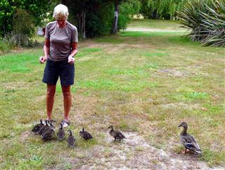
That night as we cooked our food in the kitchen area we were visited by a duck with her entourage of eight half-grown ducklings. It made cooking quite fraught with nine birds nipping in and out of our feet, begging for food and pecking our toes if we didn't give them any.
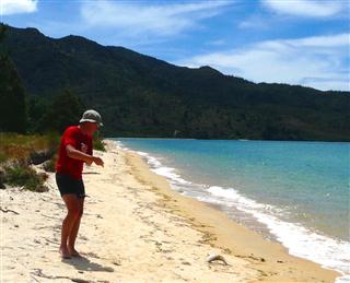
The next day was lovely and sunny so the day was spent on the beach. Steve took the opportunity to try out his newly acquired hand line. The local store sold frozen squid for bait and we sat for an hour as the tide came in with not a hint of a nibble apart from a few little crabs. Loosing enthusiasm we started to eat our lunch. Steve scarcely got his teeth into his sandwich before the reel shot off its support and into the sea. With a spectacular dive he grabbed and pulled and there was a 40cm unidentified fish on his hook. We later learnt it was a kawirai, not one of the tastiest of NZ fish but being free it tasted good to us.
The last day at Marahau we planned to rent a sea kayak and paddle around the coast. Investigating all the different companies it was clear that it would be too expensive at $110 a day. Instead we did a circular walk, climbing up from the sea to Holyoakes Clearing at about 500m. It was one of the steepest climbs we have done for years and it was hot and humid even though we were shaded under the trees.
At the top we sat on a rocky outcrop to eat lunch with a view over Torrent bay below. Then it was downhill to pick up the Abel Tasman walkway back to Marahau. The path was busy with walkers travelling in both directions. Some were fully equipped with huge backpacks and sturdy boots, others were in skimpy shorts and flip flops with just a bed roll under their arms. At the sight of the bar at the end of the track, thirst overcame economy and we couldn't resist a pint of beer.
Top of the South - Day 8 - Marahau to Takaka
- Distance 59 km
- Max Elevation 822 m
Top of the South - Marahau to Takaka Ride Profile
Ride Description
Today was the day we had been thinking about for the last eight weeks, i.e. the climb over the Top of the South's famed Takaka hill to Golden Bay. This hill is a legend in New Zealand, from sea level to 793m in 15kms. An annual bike race sees competitors complete the climb in 35mins. From Marahau we had a warm up 200m hill then back down to sea level to start the big one.
As we approached the start of the hairpins we were passed by a pretty young lady on a lightweight road bike. Dropping into first gear progress was 5.7k/h up the steep first section. The lady on the road bike was doing hill reps and soon passed us on her fast descent. As we continued she passed us three more times, each time offering encouragement and "good on yer's".
Two hours, several buckets of sweat, four litres of water, 2 Mars bars, 4 apples and several unmentionable words later we reached the summit. On the descent our 'travel on a Sunday' rule again worked in our favour as only one car passed us, we had the whole road to ourselves to fly round the hairpins. Two lads on a tandem toiling up in the other direction gave us resolve to try to find an alternative way back up for the return journey.
Being so focussed on the 'big climb' we had forgotten that from the bottom of the hill we had a 20km ride through flat farmland with a strong headwind to the first place with any services, Takaka. Arriving there, we were so tired we booked into the Kiwiana hostel, had a meal and were in bed by 9.00pm.
Top of the South - Day 9 - Takaka to Wainui Bay & Pohora
- Distance 47 km
- Max Elevation 322 m
Top of the South - Takaka to Wainui Bay & Pohora Ride Profile
Ride Description
Having reached the fabled Golden Bay we had another 10 days to kill before our pre-booked stay at the Shambhala hostel over Christmas. First we wanted to explore the east side of the bay and planned to stay at Pohora Beach camp ground. After a short 10km ride to Pohora we pitched our tent having paid the highest camping fee so far in NZ at $20 pp pn. Steve managed to negotiate a 10% discount.
After lunch we rode further along the coast stopping at the Abel Tasman Memorial on a bluff above Ligar bay. The plaque describes his journey in 1642 to find the southern continent believed to exist at that time. Unfortunately he totally missed Australia, but did discover what we now know as Tasmania. His journey continued until he arrived off the coast of Golden Bay. Here, four of his sailors were killed by the local tribe and he named the bay Murderer's Bay. Tasman left never to return. Nowadays the bay is developing with expensive designer holiday homes.
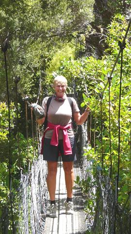
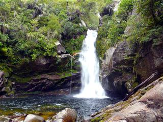
Climbing over another bluff we dropped down into Wainui bay, a large sandy estuary. The tide was high and we rode along the side of the estuary before seeing a turning to the Wainui Falls. After securing the bikes we walked through the bush, some 30 minutes up the valley. The path crosses the river via a shaky, chain link swing bridge. Looking down you get a clear view straight to the river below.
A few hundred meters beyond was yet another spectacular waterfall.
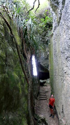
The following day, we rode to the Rawhiti Cave. Parking our bikes in the meadow, car park at the bottom of the valley, we commenced the walk by the side of a dried up river bed. After a few hundred meters, the path turns up the valley side. It snakes steeply upwards and took us about 30 minutes of hard climbing to reach the cave. As we came around a bend in the path we were startled by the spectacular, opening and realised that the climb had been worth the effort.

We had never seen stalactites like these. They were like inverted witches hats, bulbous and irregular shaped leaning out of the cave as if trying to reach the light. We descended about 20 meters down the slippery path into the cool of the cave entrance, where all around ferns and small rock plants grew.
While we were exploring and clambering around a Dutch couple who had arrived before us just sat there and seemed reluctant to enter the cave. We chatted with them. It turned out that he had a fear of falling (not of heights, but just falling). His descent was going to be challenging.
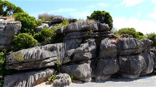
Next we moved on to the Labyrinth Rocks Park. It is an area of strangely eroded limestone rock formations surrounded by native bush, with pathways following the crevices and fissures between the rocks.
The evening was balmy. We swam in the warm and shallow water of the bay, afterwards relaxing on the beach. People were drawn to watch the sunset over the hills making for stunning photographs.
 Sunset over Pohara Bay
While at Marahau we had walked the southern end of the Abel Tasman Track. Today we wanted to walk the north end. The shuttle bus collected us and our bikes at 9-30 for the short journey to the car park at Wainui Bay. We secured the bikes there and continued on the bus over the steep, gravelled road over Pigeon Saddle to Totaranui.
The path climbs through native bush over the bluffs between bays, dropping down onto golden sandy beaches. The turquoise sea lured us in to swim every time. As there is no return by water taxi from this end of the walk, we found it less busy. The path varies between well formed, cut walkway and more natural single track. In our opinion this part of the walk way is prettier and less developed.
 Looking over Anapai Bay
Just before Separation Point, the headland where Tasman Bay joins Golden Bay, we came across our first seal, laying prostrate on the beach. As we continued towards the Point, the noise and the smell, wafting up on the breeze from the seal colony on the rocks below, became overpowering.
From here there was just one more beach for one last swim then over Gibbs Hill to return to Wainui Bay to retrieve the bikes. It was high tide when, for just two hours, the bay fills with water.
Top of the South - Day 10 - Pohora to Takaka
- Distance 9 km
- Max Elevation 21m
Top of the South - Pohora to Takaka Ride Profile
Ride Description
Today's plan was to ride to Collingwood at the west of the bay. As we left Pohara we took a short detour to 'The Grove Reserve'. This was another small park with strange, water sculpted rocks overgrown with climbers and tree roots. It was a bigger version of the Labyrinth just across the valley.
Riding into Takaka it started to rain so we went into the supermarket to shop and wait for it to pass. Then we had a coffee, then we went to the museum, then to the library for an hour on the internet. By this time it was raining more heavily and a change of plan was needed.
Just across the road was the 'Barefoot Backpackers' so, even though it was only 1pm, we checked in and spent the rest of the day in the comfortable sitting room watching the rain pouring down outside. The hostel gradually filled up with other travellers, all desperate to escape the rain. They were an interesting and eclectic mix of nationalities, ages and travel experiences and we all chatted till late in the evening.
That night the rain never stopped. We know this because our bed was so uncomfortable, with a deep squashy mattress and a big dip in the middle, that we neither of us got more than an hours sleep.
The next day dawned and still it poured so we had to stay another night, but first we had to fix the bed!! An old plastic bucket, a couple of jubilee clips, a change of mattress and it was all ship shape.
Eventually at 1pm it stopped and a quick trip to the library was possible. Again the hostel filled with damp and subdued travellers, especially those who had endured the heavy rains of the night before on a camp site. A different group of people but again very diverse and we sat round the kitchen table all night exchanging stories and experiences as well as a few bottles of wine.
Top of the South - Day 11 - Takaka to Collingwood
- Distance 33 km
- Max Elevation 82 m
Top of the South - Takaka to Collingwood Ride Profile
Ride Description
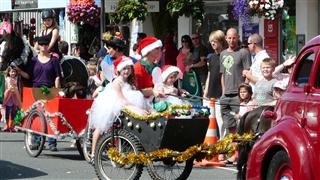
Today dawned bright and blue so we could continue our journey. As we cycled back along the main street to the supermarket, we were surrounded by the annual Takaka 'Santa Parade'.
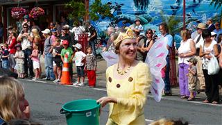
It was a strange mix of bands, floats, vintage cars, a steam engine, horses and carts, go-kart and emergency vehicles blaring their sirens.
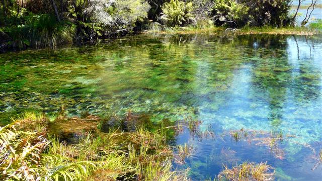
Escaping the melee we set off towards Collingwood. A short detour took us to the Pupu Springs, famous as Australasia's largest springs, producing more than 14,000 litres of water every second. The water is unbelievably clear and only the water under the Antarctic ice shelf is clearer. It would make a fabulous swimming pool but all contact with the water is banned because of the fear of the Didymo algae (common name 'rock snot') getting into the water.
The ride to Collingwood proved to be more challenging than the easy, flat ride we had expected. There were several, quite steep hills. On the way to Collingwood, we passed by the hostel that we had booked for Christmas, called Shambhala. We had arranged for some cycling gear to be delivered there, so we called in to pick up Karen's new jacket as we had been told there would be more strong rain to come.
Arriving in Collingwood we checked into the camp ground, right by the estuary.
That evening we sat in the site common room and cringed as we heard the rain start again.
For three days it rained constantly, in varying levels of intensity, from light drizzle through to torrential rain accompanied by thunder and strong winds.
We spent most of our time in the camp community room working on the computer, writing our blog, reading magazines, but not watching the lousy NZ television.
Camp Mother (alias Diane) was very concerned for our welfare and was astounded at our stoicism, as gradually everybody else left the camp site. By the third night, we were the only ones left.
The tent stood up well to the hard rain and gale force winds, being pitched on a sandy base helped, but mainly because we were on a slight mound.
We learned that 350mm of rain fell over five days. The River Aorere, which flows into the sea by the camp site rose dramatically, flooding the roads and fields along the valley. It was a raging torrent with huge trees and other forest debris for the next 24 hours. Then as quickly as it had risen it subsided back to normal.
The rain usually stopped in the evening and Steve decided to do some fishing, as the tide was coming in. After only ten minutes he hooked into another large Kawahi weighing about 4 kilograms. It put up a brave fight before being landed. It was such a beautiful fish that Steve didn't want to kill it, but it was dinner and served us well for the next two nights.
We were able to do ALL of the Collingwood tourist attractions in about 2 hours between rain storms; the Gibbs Lookout, the "historic" cemetery, the tiny but interesting museum, the court house (now a cafe) and the chocolate shop.
Top of the South - Day 12 - Collingwood to Farewell Spit
- Distance 25km
- Max Elevation 20m
We have omitted the profile as the road was flat all the way.
Ride Description
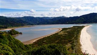
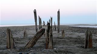
On the fourth day the sun shone and we rode up to Farewell Spit, the long curving spit of sand at the very tip of the west coast of the top of the South Island. When viewed from the air it looks like the beak of a Kiwi.
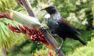
We stopped for coffee at the Paddlecrab Cafe and admired the view across the Bay. The spit disappeared into the mist along its length. As we drank our coffee a Tui bird flitted from one plant to another sucking the nectar from the flowers.
We walked along the beach on the Golden Bay side of the spit. The tide was in and there wasn't a breath of wind. The water was flat calm. Floating on it were about 200 or so beautiful black swans. Most of them were sleeping with their heads tucked under their wings, we assumed they were waiting for the tide to go out.
 Black Swans at Farewell Spit
From there we followed a footpath across the centre of the spit, which was more forested and marshy than we expected. Emerging through the sand dunes at the other side we were met by strong winds from the west, huge ocean rollers and a fine sea spray which gave the scene a wild feel.
The wave action had carved deep channels and pools in the beach.
 Windswept Fossil Point
As it was high tide they were filling with water and a single seal sat in each guarding his territory.
 Seals at Fossil Point
Returning to the east side of the spit the tide had retreated and all of the swans were standing on the beach, apparently in the same places that they had been floating. We assumed they were waiting for the tide to come in.
Lunch was eaten on the beach at the village of Pugonga close to the spit.
There are the remains of an old jetty stretching into the bay and small pieces of weathered coal lying on the beach, reminders of the areas strong mining history.
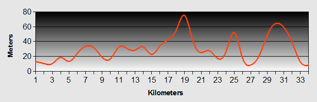
Top of the South - Day 13 - Collingwood to Onekaka
- Distance 170km
- Max Elevation 50m
Profile omitted as it was flat.
Ride Description
Packing our gear, we left it at the camp site office while we went for a trip up the Aorere valley. We had coffee at the Naked Possum which also has small tannery producing items from possum pelts. Steve was disappointed to find that they didn't have any possum fur nipple warmers left, (or maybe they never made them and this "must have" product was just a figment of his imagination).
 Kaituna Track
Returning to the camp site we loaded the bikes and headed back to Onekaka for our Christmas holiday stay in the Top of the South at the Shambhala hostel. Before the turn off to the hostel was the famous Mussel Inn with its own micro brewery. It was mandatory to stop and sample their brew.
The hostel is about 2km off the road, down a rough track. The final 50 meters was a push up the hill. Arriving at Shambhala we were rewarded with tranquillity and a wonderful view across the bay.
We met John, the owner who struggled to recollect our booking and couldn't find it in his little book. "However" he said, "don't worry, we have space" and proceeded to take us through the bush to a little cabin hidden away on its own. The ablutions were 200 meters away up the hill (except for a small handbasin and gas cooker). The only light was a miniscule LED light bulb in the ceiling. (note this is an eco friendly hostel). We were not impressed and felt we had been palmed off with the worst accommodation, despite having booked weeks in advance and having had communication with John over several weeks.
Over the next four days however, our attitude would change. Shambhala is a Buddhist retreat in extensive landscaped gardens. Throughout the gardens are guest cabins, a small tea house and yoga / meditation room. Its peace and tranquillity worked its magic on us. Our cabin was very quite and private with its own resident hedgehogs. We swam in the sea, walked along the beaches, read, and ate. At the end of our time there we were thoroughly chilled.
The first evening we walked 2km to the Mussel Inn for our Christmas treat. Coming back after dark we took a small path through the woods to see hundreds of vivid glow worms on the moss covered rocky outcrop along the path's length. It was like looking at stars in the night sky.
On Christmas Eve, we had a communal meal with the other guests. After dinner we were serenaded by a local artist, Hanna Ohwileo. She had a unique and haunting voice. Another couple from Australia also sang in close harmony. There were no carols sung or Christmas decorations. There was no opening of presents on Christmas day. It was a very pleasant change to the manic, grasping materialism of Christmas in a lot of the Western World and it really helped us cope with being so far away from family and friends.
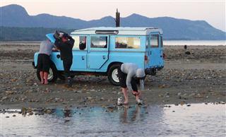
On boxing day we walked along the beach to where a small river meets the sea. There was a large group of local folk playing softball on the beach, crowding around the camp fire and enjoying a barbecue. We stopped and chatted with three divers who had been fishing. They were just loading their stuff back into their Landrover. As we walked on they sped passed us at high speed causing a large plume of spray as they forded the river. The Landrover promptly spluttered to a halt, to the loud cheers of everyone on the beach.
Top of the South - Day 14 - Onekaka to Motueka
- Distance 20km
- Max Elevation 546m
Profile omitted as we took the bus.
Ride Description
All too quickly our time in the Top of the South was up and we packed our bags ready to move on again. We had to get out of Golden Bay otherwise we may never leave. Come the morning, it was dismal, grey and raining a soft drizzle. We had already decided that we would get the bus from Mussel Inn to the top of the infamous Takaka Hill as we couldn't bear the thought of toiling up there for two hours. When the bus driver picked us up he assured us that the weather on the other side of the hill was fine.
He was right. As soon as we cleared the brow of the hill the cloud thinned and the sun came out. As we descended we had to keep stripping off a layer of clothes it was so hot. The traffic on the hill was mainly going upwards, towards Takaka, as New Zealand families set off for their summer holidays. Each car was packed with parents and children, with a huge trailer behind carrying all the holiday essentials; tents, food, beer, canoes, fishing gear, bicycles, scooters, a huge amount of stuff to haul up that big hill. We were glad we just had our bikes and bags and were speeding down the hill in the opposite direction.
In Motueka we returned to the White Elephant hostel to pick up our stored baggage and camp overnight before heading up to the Nelson Lakes tomorrow. The weather forecast for the next 24 hours was torrential rain, up to 600mm, and gale force winds. Time to peg the storm guys out.
New! Comments
Have your say about what you just read! Leave me a comment in the box below.