Bicycle Taiwan East Coast for an Amazing Adventure
Bicycle Taiwan East Coast? Why not? Taiwan is not one of those countries that springs to mind when thinking of doing a cycling tour and yet it is so well set up for bicycle touring. The major bicycling company Giant has its its main manufacturing base here and has done a lot to promote cycling throughout the country. They even run a scheme whereby you can rent a Giant bike at one of their outlets go on a tour and then drop it off at a different Giant outlet. The Taiwanese government has also made great strides to improve the quality of its rivers and what were once polluted waterways are now clean recreational areas with great bike tracks following some of the major rivers.
Bikes can not just be taken on trains but are welcomed. Straddling the Tropic of Capricorn, the countries weather is partly temperate and partly tropical so it exhibits a good environment for cycling. The mountain and coastal scenery is stunning and there are plenty of bed and breakfast accommodations as well as camp sites and more up market hotels at reasonable prices. You can even stay at the local police stations or pitch a tent in their gardens.
Seven Eleven stores abound and you are never very far away from civilisation but you can still get away from the crowds and enjoy this wonderful country.
Flying into Taipei, Taiwan's capital is easy with major airlines flying several times a week. We flew from Manila with Cebu Pacific
Taipei
We had booked three nights in the 'Dandy Hotel' which is number 1 on Trip Adviser. It was very good, although a bit far away from the centre of the city. We spent a day exploring the city and the second day putting the bikes together and buying last minute things from a pretty good bike shop just down the road.
 The Red House
The best thing about Taipei is it's efficient transport system. The MRT is easy to use, with a ticketing system very similar to London underground. All the stations are announced in English as well as Mandarin.
 Feeding the Birds in the Taipei Peace Park
The buses are well labelled and all destinations are in two languages. There is a constantly expanding cycle path network. Most of the rivers have paths on both banks and it is easy to go from the suburbs into the city along these.
 Temple Offerings
We wandered round the Peace Park, watching the children feeding the birds, did a couple of museums and temples and spent an hour watching, but not comprehending, the puppet theatre.
 Taipei Puppet Theatre
Schedule
Our ride descriptions give an account of the ride that we completed. As part of the description we also provide links to Wikiloc or Google maps and elevation profiles based on mapping data available through the internet. The ride profiles are smoothed to give what in our opinion is a more beneficial view of the profile. We use paper maps, GPS and on line data to plan and conduct our rides. We are happy for you to use our descriptions, but be aware that we do not guarantee the accuracy of the information provided as situations surrounding any ride change over time.
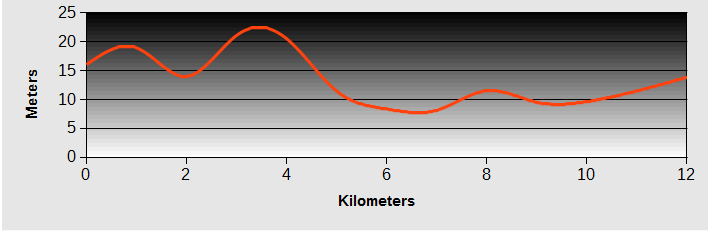
Bicycle Taiwan East Coast - Day 1 - Taipei to Bajia Bay
- Distance 47km
- Max Elevation 58m

Bicycle Taiwan East Coast - Taipei to Bajia Bay Ride Profile
Ride Description
It was a slightly nervous departure for both of us this morning after a break from touring for four months. Using the Taipei Metro Tourist map and the sat nav on the phone we found our way through the back streets and onto the amazing cycle path which follows the bank of the Suangxi river.
 The Suangxi Cycle Path
Apparently just 10 years ago hardly anyone used bicycles in Taipei city and all the rivers were badly polluted and blocked with rubbish. Now there are cycle tracks following all the major rivers which are very popular, especially at the weekends. The water quality is vastly improved and there are now masses of fish and fishermen, birds and human.
 Too Stuffed to Move
The sky was blue and the temperature was already in the high 20's but there was a cooling breeze and it was good to be avoiding the busy rush-hour traffic which we could see crossing the bridges above our heads. In the shade of a river bridge was a group of dancers practising their ballroom steps and along the path people were using the exercise machines and jogging.
 Ballroom Under the Bridge by the Side of the River
The Suangxi joins the Keelung and then flows into the main river of Taipei, the Tamsui. On the river bank at this junction was a fabulous little cafe serving coffee. Probably the last we'd get for a while. The cycle path continues right to the mouth of the Tamsui at the East China Sea and the 'Fisherman's Wharf harbour.
 The Bridge at Fisherman's Wharfe
From here we joined the main (only) road, Highway 2, along the northeast coast. This is a dual carriageway with wide hard shoulders but surprisingly little traffic and so instead of going up into the higher hills on the minor roads, as we had planned, we continued on it. The ride was easy, over rolling hills. The coast here is OK but not spectacular.
 Oyster shells set in lava
Bajia bay has a wide sandy beach and is popular with swimmers and surfers from Taipei. It was packed with young locals and families and very tightly controlled by the lifeguards. We booked into the Sun Family Guesthouse, the only accommodation marked on the Google map. The room was large but the unopened condom packet left strategically on the bedside cabinet with generous supplies of tissues on the other side suggested it was often rented by the hour.
 Bajia Bay
That evening we received an e-mail from Laurie, who we met at Atmosphere the previous week. She works for Cirque du Soleil and their World tour show was opening at Taipei Arena the next night. She had a pair of tickets for us and we were over the moon. Well worth cycling back to Taipei for.
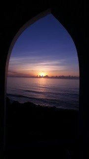
 Sunset at Baija Beach
Bicycle Taiwan East Coast - Day 2 - Bajia Bay to Taipei
- Distance 61 km
- Max Elevation 78 m

Bicycle Taiwan East Coast - Bajia Bay to Taipei Ride Profile
Ride Description
It felt really hot today as we were in the lee of the hills, so sheltered from the cooling breeze. Highway 2 followed the coast to Fuguei Cape where we turned off to visit the lighthouse.
 Fuguei Cape Lighthouse
There was a pleasant, narrow, cemented road from the car park to the lighthouse, giving good views over the sheltered sandy bay. On the beach here is the 'Green Reef' . Looked more like a few rocks covered in algae.
 Fuguei Cape Beach
From the car park we picked up a bike route that took us back onto the highway at Lomei. Along the coast a little was this impressive archway at Shimen Cave.
 Shimen Cave
As we continued along the coast it seemed like this area was formally very popular with plenty of cafes and restaurants to cater for tourists. But now a lot of them were falling to pieces and mostly closed. So there was no morning coffee today and it all looked rather ugly.
The road turned inland and there was a slow hot climb over the eastern headland before a cooling descent into Keelung. At the bottom of the hill was a MacDonald's which was irresistible. A Big Mac Meal later we set off again to find the NR5 back to Taipei. There is a cycle route along the banks of the river to avoid the traffic but the long meanders add a lot of extra kilometres and we wanted to get back in time to have a rest before heading to the show.
The heat was intense and Karen was badly affected climbing a long slow hill and then having to wait at traffic lights at the top in the full sun. Luckily there was a high rise building at the hill summit with some welcome shade and a 7-11 for cold water. The 7-11 stores are a cycle tourers dream. Cool, cool air conditioned shops with ATMs, clean toilets,cold and hot drinks, snacks, meals and tables and chairs to eat at.
It was 5pm before we checked into our hotel. It was within 'walking distance' of the arena but it was still quite a hike. Laurie met us as arranged and our tickets were on the very front row, right in the front of the stage. As usual photography during the performance was prohibited, but during the interval a group of the main dancers held a Michael Jackson dance class right in front of our seats.
 Cirque du Soleil
The show's title is ' Michael Jackson, the Immortal'. It was by far the best show we have ever seen with the most amazing acrobatic performances and stunning dancing, lighting and set. See it if you can.
 Cirque du Soleil
Bicycle Taiwan East Coast - Day 3 - Taipei to Fulong
- Distance 58 km
- Max Elevation 60 m

Bicycle Taiwan East Coast - Taipei to Fulong Ride Profile
Ride Description
The good thing about last night was we hadn't been able to find a drop of beer anywhere so our heads were clear when we woke even though the legs were stiff.
Heading out of Taipei again was a reverse of yesterday: along the river bank and onto NR5 back to Keelung and onto Highway 2, after a quick coffee stop at Starbucks. It was Saturday and there was a lot of traffic on the road, a combination of scooters, 4WD and lorries carrying quarry materials. The highway was only two lanes, with no separate cycle lane but always a wide hard shoulder and traffic was nose to tail in both directions.
 Meiyanshan Seafront
Because we were travelling south, every time we wanted to take a photo or see a sight we had to wait ages to cross the road. It was also a hot, hot day with cloudless skies. At lunchtime we arrived at Bitou, with a little sea-food restaurant overlooking the harbour and its fishing boats. There were stacks of aquariums containing all manner of live sea food to choose from. We tried to order but the waitress did not want to try to understand. Another woman in the queue spoke good English and helped us out.
 Huang Gang Biang - Wave Formed Rocks
Full to the brim with prawns and clams we departed Bitou through our first Taiwan tunnel, only about 200m, but good practise for later. The rocky coast here has lots of interesting wave sculpted cliffs and boulders but the heavy traffic made the journey a bit tedious. The most famous rock formations are at Nanya, which we hit at the hottest part of the day.
 Nanya Rocks
At the top of one cliff were a group of divers just returning to their car. They had all climbed from the sea, up about 75m of cliff in full wetsuits, jackets and tanks in 36C heat. That's dedication to diving!
 Divers climbing the cliff with full kit, 36C heat
We missed the beginning of the next stretch of cycle path, along the coast from Yanliao Coast Park into Fulong but tried to pick it up at the Longman suspension bridge over the river Shuang. From the road there was a 25% climb up a narrow track and after all that hard work the bridge was closed because of a cable break.
There is footbridge over the river towards Fulong and we thought we may be able to get across there but it meant crossing the long wide beach and the sand was just too soft and deep to push the loaded bikes across.
 Longman Suspension Bridge
So it was back to the highway and over the new bridge. Fulong was heaving with traffic and crowds. There was a sandcastle building competition on the beach and consequently all the hotels (well, the three that there are) were fully booked. At the third place the man said he had a single room in the basement and in desperation we accepted that.
It was small, just big enough for a wide single bed with the hardest mattress, no windows, tiny doorway and the bulb in the bathroom didn't work. As soon as the shower went on, little crabs started to climb up the drainage hole and invaded the bedroom. Not big enough to do any harm but not the best bedroom companions. We stuffed tissue into all the holes but a few kept appearing from under the bed.
 Bedroom Crabs
After showering and changing we set off to walk to the beach and see the sandcastles. The only access is over the footbridge, which is accessed through a big resort hotel. It was still light and only 5pm but everyone was leaving and the guard would not let us through. So we didn't get to see them.
Bicycle Taiwan East Coast - Day 4 - Fulong to Yilan
- Distance 52 km
- Max Elevation 35 m

Bicycle Taiwan East Coast - Fulong to Yilan Ride Profile
Ride Description
Our little room in the bowels of the earth had no natural light, so it was 8am before we woke up. After a quick check of the floor for crabs we leapt out of bed and got packed up quickly and emerged into the cloudless, hot morning. After a fruitless search for breakfast we shopped in the 7-11 and then had a picnic in a shady spot on the cycle path.
 Fulong Beach
This section of the coast has a dedicated cycle path for about 15km around the mountainous headland, mostly running at the side of Highway 2. Alternatively there is a shorter cycle route directly across the headland which runs through an old railway tunnel. Along the coast are some small villages with remnants of the original fisherman's cottages.
 Ang Oa Fishermen's Houses
As it was Sunday there were loads of cyclists. About 50% were on hired bikes, the rest on folding bikes which are carried free on trains. So from Taipei you can get the train out to here for the day. There was much less traffic today which was a relief. Hardly any lorries but more groups on powerful motorbikes. The shores are mostly rocky with wave sculptured outcrops and were crowded with people fishing with rods.
 Yellow suited temple dancers
At the temple in Dali, we stopped to watch the local ladies dancing in their yellow suits and shoes. People were queueing to burn sacrificial money in the huge stove.
 Sacrificing Money at Dali Temple
The road continues to hug the coast as far as Toucheng city which lies at the northern tip of the large, triangular plain at the mouth of the Yanglang river. There are several lengths of cycle path along this section of Highway 2, but they are not well signposted and always on the coast side of the road so it is difficult to cross over to use them if going south. The road was mostly flat but the head wind slowed us and made us work hard.
 Megang Black Hair Reef
We did find the cycle route round the outskirts of Toucheng to avoid the busy centre. There was some sort of motor rally going on and all the cars were lined up along the side of the road. After Toucheng we turned off Highway 2 onto the quieter NR191 towards Yilan, through agricultural land. We were frequently attacked by pairs of Jay-like birds who swooped and squawked at our heads, making us glad to be wearing helmets.
 Rally Prep Toucheng
Yilan is one of those towns that has been divided by both a railway running north to south, and a raised highway running east to west. We sat in a 7-11 next to the raised highway, enjoying the cool air conditioning and watching the spectacle of a minor RTA being dealt with by the local emergency services. Despite the only injury being a slightly grazed shin, it required three police vehicles,seven police, an ambulance and several statements.
In the town centre we found a little newly opened hotel with very nice rooms and had an exceptionally tasty meal of spicy crab at a tiny eatery.
Bicycle Taiwan East Coast - Day 5 - Yilan to Xincheng and Taroko Gorge
- Train from Yilan to Xincheng and then 33 km cycle ride up the lower stretches of Taroko Gorge and back to Xincheng
Ride Description
This morning's breakfast earned the distinction of being the worst offering since China. There was a meagre selection of delicacies laid out on a counter. Despite the vast quantities of very cheap fruit for sale everywhere there was just a very small bowl of lychee. Next to it was a plate of peanuts, then a bowl of something greyish brown, in liquid. Thinking it was some sort of stewed fruit it went on the plate but on tasting it turned out to be stewed mushrooms. Just along from that was a vast vat of pork in gravy which looked like it had been sitting there for at least three weeks and some overcooked vegetables. The only alternative was old, sliced rubbery bread and margarine.
 Call this breakfast?
South of Yilan the coast road, Highway 9, becomes a narrow, two lane road, with no hard shoulder, climbing up along a mountainous coast and passing through several long tunnels. The road is used by many heavy lorries carrying gravel from the quarries as well as huge numbers of tour buses. Several cyclist's blog pages describe it as a very frightening and dangerous road and so, with memories of the lesson learnt from the road up to Andermatt in Switzerland, we decided to take the train to Xincheng.
 Train carriage leaving Yilan
We cycled to the station expecting that there might be a long wait as not all the trains will carry non-bagged bicycles. Instead, the next local train was leaving in 30 minutes and was already at the platform. Bikes are carried in the rear carriage and there are bench seats along the carriage sides with a wide space in the middle. With very few other passengers we could sit down and hold the bikes steady in front of us. More and more passengers came on at the various stations and then 19 more cyclists with bikes all crowded in. It was quite a squeeze.
 Train carriage + 19 more bikes
The train reached the end of the coastal plain and as we crossed a level crossing there was a long queue of tour buses on the highway and a strong wind blowing from the south. Beyond that about 66% of the journey was through tunnels. Occasionally the line emerged from the darkness into a river valley, each one with massive gravel extracting plants and a tiny station with no-one getting on or off the train.
When we got off at Xincheng we had to take the bikes down the steps and back up the other side to reach the station exit. After lunch we checked into a hotel and as it was still early afternoon we decided to ride a little way up the Taroko Gorge.
 Meaning Lost in Translation
This is the most famous gorge in Taiwan so we were quite surprised by the lack of traffic. The road rises steadily and the gorge gradually deepens and narrows. After about ten kilometres we came to the tail end of a queue of traffic. As nothing was coming towards us we continued past the line of vehicles to the front where there was a big board informing of the times each day when the road would be open.
 Heading to Taroko Gorge
There had been a massive landslide about six months before and, while the debris is being cleared, the road is only open for 10 minutes every two hours.`With a high risk of rock falls from the unstable gorge walls, hard hats were recommended so we were glad to have our cycle helmets.
 Taroko Gorge
The road continues to wind its way through the towering gorge, through tunnels and over bridges. With so little traffic, it was a really enjoyable ride with stunning views.
 Taroko Gorge
We timed our return so that we wouldn't have too long to wait for the road to open and there was again a huge line of traffic waiting. The cyclists and motorbikes were allowed through first and the whole group set off downhill fast, but suddenly Karen's wheel was skidding as she had a flat. With the narrow road and no hard shoulder we had to wait until all the traffic had gone down before there was space to take the wheel off and repair the puncture.
 Taroko Gorge Landslide
Bicycle Taiwan East Coast - Day 6 - Xincheng to Cliff House
- Distance 74 km
- Max Elevation 220 m

Bicycle Taiwan East Coast - Xincheng to Cliff House Ride Profile
Ride Description
Today we managed to avoid riding on the highway (now 9) for most of the morning. First on a local road out of Xincheng. After just a couple of km on the main road, there was a bike way signposted to the left . It followed NR913, a quiet, local tree lined road running parallel to the coast. It went through the middle of one of the largest Chinese graveyards we have seen, a vast village of traditional little houses, all with gated, walled gardens.
 Cemetry Town
The NR 913 goes into the centre of Hualien City but we turned off onto another cycle path along the seafront. Most of it appeared to be only just completed and it was a lovely traffic free route past the airport and along the prom then turning in through a park and crossing several bridges before coming into another wide sweeping bay.
 What a bicycle way should look like
At the end of the beach it turned inland again and started to climb up a zig-zag path. After a couple of turns we came to a short flight of steps with a sloping ramp to push the bikes up. This was quite difficult with a loaded bike. Round the next corner were five more flights of steps. Seemed a strange way to design a bike path.
We reached the penultimate flight, sweating profusely and were confronted by four soldiers dressed in jungle camouflage and none of them old enough, surely, to have left school. They signalled to us to go back as the track was closed. Steve was sent to negotiate as there was no way we were going back down those steps and about 2km round the bay to get back to the road.
 Bike way with steps?
Eventually the most senior one rescinded and let us through. The youngest recruit had been stationed further down the road and had fastened a rope across the road, between two trees. He had tied it so securely it took several minutes for him to undo the knots so we could go through.
By now we were at the port, on the south side of Hualien and continued along Highway 11. Lunch was another delicious fresh seafood feast with lobster and clams. After the food the road seemed longer and hotter than ever, with a strong head wind. There were several sections of cycle track on the coast side, but there was not much traffic and more shade from the roadside trees on the hard shoulder.
Ahead was a large rocky headland and we thought we were going to have a steep climb. Instead the road climbed very gradually through three long tunnels, in total about 3km, broken by two very short sections of daylight. They were well lit with a clearly marked cycle lane and as the traffic was light it wasn't quite as daunting as some of the shorter tunnels.
 Descent towards Fengbin
Emerging from the darkness, it was amazing to see how high we had climbed. There were still several more hills to go and the headwind made each of them seem twice as steep. The amazing views made up for the pain and of course, every climb has a thrilling descent. On the negative side, the traffic in the afternoon was much heavier, mostly tour buses heading north. We were tired now and anxious to find somewhere to sleep and there seemed to be nowhere. The villages here were poor, few shops and worse, no 7-11's.
 Roadside sculpture, made from driftwood
The Google map showed a bed and breakfast place called 'Cliff House', near the 46km marker and we pinned all our hopes on this. It was a lovely house built right on the sea edge.The building style could be described as eclectic, somewhat Greek style but the interiors had unusual shaped alcoves and angled fittings. Our bedroom had a little balcony overlooking the sea and a huge bathroom with a sunken shower area.
Being a long way from anywhere, they included an evening meal in the price. It was pleasant enough, made mostly from ingredients grown in the garden, but unimaginative, just steamed rice and dishes of fried vegetables.
Bicycle Taiwan East Coast - Day 7 - Cliff House to Yiwan
- Distance 55 km
- Max Elevation m

Bicycle Taiwan East Coast - Cliff House to Yiwan Ride Profile
Ride Description
After getting up to watch the sunrise at 5.10am, we went back to bed for two hours until breakfast time. As we set off our host gave us a bunch of bananas from the garden.
The whole day's ride was on Highway 11, rolling slightly as it follows the coast south. Up until 11am the traffic was light but then the coaches became a bit tedious. For a large percentage of the day there was a separate cycle path.
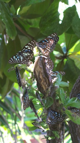
Our coffee stop was at a cafe at Shihtiping where we watched a big group of butterflies feeding on tree sap while we sipped our ice coffee.
The headland here has some smoothly carved rocky outcrops and a nice looking campsite with shaded platforms to pitch the tents.
 Shihtiping Campsite
Further south is the Tropic of Cancer monument, a huge white tower with a split in the centre, built at the point where the tropic crosses the Taiwan coast. Of course it was busy with tourists and we had to wait a while to get a decent photo. But at least there were plenty of budding David Baileys to take one of the two of us.
 Tropic of Cancer
By lunchtime we arrived at Bashian Cave, another tourist hot spot. The road was lined with coaches and a row of restaurants were filling with groups. We went into one and were offered a 'lunchbox'. This was a cardboard food box, filled with rice, meat, fish and vegetables. A delicious meal for only 45 dollars (one pound) each. The tables were all massive round ones, seating about fourteen people and everyone was full except for our, with just the two of us. We felt like Mr-and-Mrs-no-mates.
Lunch over we gave the caves a miss and pushed on. All around the coast of Taiwan, the town police stations provide support for touring cyclists with free air and water. Some also have space for camping and bivouacking. If really pushed we wondered if they would offer us a bed in an empty cell. We made good use of the free water today.
At Yiwan we found a bed and breakfast place run by a young couple with very nice, clean, big rooms overlooking the sea. It was a long way back into the town for an evening meal so the owner gave us a lift in his car and returned to pick us up when we had eaten.
 Billy no Mates
Bicycle Taiwan East Coast - Day 8 - Yiwan to Fushan
- Distance 51 km
- Max Elevation 80 m

Bicycle Taiwan East Coast - Yiwan to Fushan Ride Profile
Ride Description
The day dawned bright and hot as ever. The breakfast was pretty good and we set off in good spirits. Highway 11 continued south and we turned off after a few kilometres to ride along the sea wall at Sansiantai where there was this rather stylish deer, made out of wood debris from the beach.
 Shiti - Deer Sculpture
There is a small island close to the shore here with an eight arch bridge connecting it to the mainland. The first tour bus of the day had just disgorged its passengers so we had to share the views. A local fisherman was just returning to his car with an enormous octopus in a net. From the car park was a short section of cycle track along the coast through shady woodland.
 Sansiantai Eight Arch Bridge
Chengong was the next sizable town and we considered stopping there for the night. But the budget hotels were all old and crumbly, this one being the worst example and the most aptly named, except for a slight spelling error, as The Sin Bin. So we carried on after a (very expensive) cup of coffee.
 No Takers for the Sin Bin Hotel
At lunchtime we were cycling up a quiet road into Donghe, looking for food when we came across a taxi, slewed across the road with its bumper resting against a wall. The engine wouldn't start and no-one seemed interested in helping. So hero Steve (with two others) abandoned his bike and pushed the car back onto the road.
Just down the street we found a busy place selling the best steamed dumplings we have ever tasted. It was crowded with tourists and several groups of touring cyclists who we chatted to. It seemed like the must-do tourist food stop, a bit like Harry Ramsden's in Yorkshire.
 Crossing the Donghe bridge
The final tourist stop of the day was 'Water Running Up', a typical, pointless' tourist attraction' with a concrete water channel which, because of the angles of the road on one side and the bank at the other, appears to flow upwards. At least they didn't have the cheek to charge for admission.water
 Water Running Up
The plan was to ride into the last major city on the south east coast, Taitung, but with only about 5 miles to go we saw a Bed and Breakfast place with an Italian restaurant. They were fully booked but a little further along the road was another place, unmissable because of the windmill on the roof. We thought if we stopped there we could have a swim in the sea before dinner at the Italian place.
 Ocean Sky 11
But that was before we realised that we had left our plug adaptor in the bedroom in Yiwan. All of our electrical gadgets need it for charging so next thing we're in a taxi heading back to pick it up. It's amazing how far you can travel on a bike in 7 hours. The taxi driver took it easy on the way there. But coming back he got a bit bored and started driving like a madman, too fast, overtaking and undertaking. It was a relief to get back in one piece.
For dinner we went to the 'Italian' . Any hopes of pizza or decent pasta were soon dashed. The 'pasta' was in fact cold noodles served with yogurt, fresh fruit and chicken.
Bicycle Taiwan East Coast - Day 9 - Fushan to Taitung
- Distance 12 km
- Max Elevation 25 m
Bicycle Taiwan East Coast - Fushan to Taitung Ride Profile
Ride Description
Taitung was just a short ride away. The road goes past the end of the military airfield and the sound of the F16's taking off was deafening.
It was Friday and high season in Taiwan. Going away for the weekend is very popular so we decided to book into somewhere for three nights. The best value place, called the 'Travelers Hostel' was fully booked but a last minute cancellation meant we could stay, moving to a different room each day.
Taitung had a lively night market and lots of good shopping. and eating places. It was the weekend of the Wimbledon finals so we spent the evenings watching Fox sport on the flat screen TV in the bedroom. During the day we explored the city and it's parks.
 Crossing into Taitung
The Forest Park on the north side was an area of reclaimed land with nice shady cycle paths and lakes. The coast is on the Pacific ocean and with a stiff onshore breeze the rollers were impressive so although it was weekend and hot there was no-one on the beach.
 Taitung Forest Park
While we were wandering round the busy night market a lady on a bicycle stopped Karen and started speaking to her in Mandarin. She kept pointing to her thighs and grabbing her arm, trying to take her somewhere. Steve got a bit cross and thought she was touting for some business but Karen wanted to understand what she was trying to say so went with her.
 Taitung Night Market
She took us to a chemist, chatted with the pharmacist and then presented Karen with a pack of NSAID pain relief patches and left quickly. The pharmacist, who spoke some English, explained that she had been upset to see Karen limping so badly and though she must be in terrible pain.
 Leopard Cat
Bicycle Taiwan East Coast - Day 10 - Taitung to Dawu
- Distance 56 km
- Max Elevation 140 m
Bicycle Taiwan East Coast - Taitung to Dawu Ride Profile
Ride Description
We were ready to leave at 8.15am but the route out of town passed our favourite coffee shop 'Donute' and we couldn't go past without having a quick latte.
The route continued south, first on Highway 11 following the coast. Leaving Taitung the road is a dual carriageway with a hard shoulder. The wind had dropped and the Pacific looked flat and blue. About 8km south the road joins Highway 9. The morning traffic was light and mainly cars so we made good progress on the undulating road. There were a few sections of newly constructed road with the old road running parallel which was much quieter. On other sections there were on-going roadworks, reducing the road width to 1.5 lanes.
 What breakfast should look like.
We climbed up to about 150m a couple of times, giving us wonderful views of the rocky coast.
There were lots of cyclists coming north, mostly groups of young men. They are all fanatical about covering themselves to keep the sun off and wear long trousers, long sleeved tops and cover their heads and faces as well as wearing a helmet.
Shangw was the last place with accommodation before the 500m climb over the south east peninsula. We decided to stop there and set off to do the climb in the relatively cooler morning. There was a hotel just across the road from the little harbour. The lady owner didn't speak any English but was very friendly and helpful.
 Shangw Harbour
Of course dinner had to be seafood, a lovely freshly caught, unrecognisable fish and some prawns at a place near the harbour, on the table next to the temple dancers, all dressed in their yellow suits and shoes.
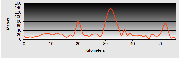
Bicycle Taiwan East Coast - Day 11 - Dawu to Henchung
- Distance 60 km
- Max Elevation 450 m
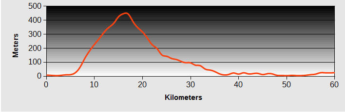
Bicycle Taiwan East Coast - Dawu to Henchung Ride Profile
Ride Description
Breakfast was not included at the hotel so we had dumplings and coffee at the 7-11 just down the road. Even at 7am it was pretty hot and the humidity was high. There was about 5km of flat road to get the muscles warmed up before before Highway 9 turns inland and starts to climb.
 Road from Taitung
It was an easy gradient and at this time in the morning a lot of the road was still in cool shade. There were three other cyclists also climbing, and we kept meeting up with them at the rest stops on the way up.
 Giant Moth
At the col at about 480m there was a cyclist rest stop with seats, toilets and fresh water. From here we turned left onto the NR199. This was a lovely, narrow country road, no buses allowed, and very little other traffic.
 Bike Stop at the Top
Having worked hard for the last 90 minutes we enjoyed the long downhill through jungle covered hills and the views towards the sea and of the reservoir lower down.
 View Back to the Sea
Clouds of butterflies fluttered around the road sides and the lily's flowering in the small valleys overwhelmed us with their scent. One of Steve's spokes on the back wheel broke and so we had a quick pit stop to replace it.
 Traffic Free Descent
All good things have to come to an end, and at the bottom of the descent we had to re-join Highway 26, noisy, busy and into a head wind Henchung. That night we found a ate at a Reggae themed bar with good music and food.
 Reggae Bar in Henchung
Bicycle Taiwan East Coast - Day 12 - Hengchun to Kenting National Park
- Distance 18 km
- Max Elevation 40 m
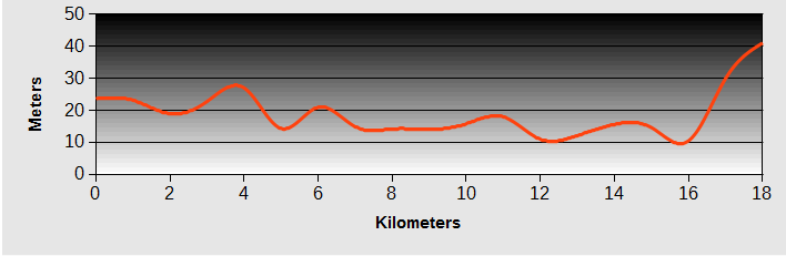
Bicycle Taiwan East Coast - Hengchun to Kenting National Park Ride Profile
Ride Description
The morning was spent exploring Hengchun which has some gatehouses and an old city wall. It is the first place we have found in Taiwan with a little history remaining, but even this has had to be mostly re-built following its destruction by the Japanese in the early 1900's.
After that we rode down to the South East point of Taiwan at Cape Eluanbui. This coast is the 'Costa Del Sol' of Taiwan with many hotels and up-market resorts charging ridiculous prices. All along the road are businesses set up to entertain the visitors: Go-karts, electric cars, scooters, dodgems, horse riding.
 Hengchun Southgate
There are only a couple of sandy beaches and these are packed with sun-beds and umbrellas. The sea is full of jet-skis and motorboats. We stopped to take a photo and a girl wanted to charge us for parking!
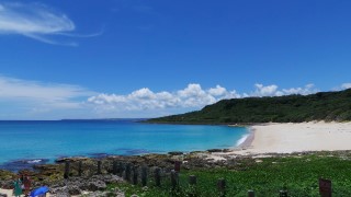
South of the main resort town of Kenting is the National Park which protects this scenic area from further development. Even the beautiful pale sand beaches here are protected and no-one is allowed to go onto them.
On the cape is a lighthouse, built in the late 1800's after several ships had perished on the rocks there. Because the area was still populated by indigenous tribes who attacked it, it had to be fortified. It is one of only two such lighthouses in the World.
As you would expect, it was heaving with bus-loads of tourists. But they confined themselves mostly to walking up and photographing the lighthouse. All the way along the path were street vendors selling 'lighthouse' memorabilia. It was identical to all those trinkets people buy on the streets of Whitby and Robin Hood's Bay.
 Eluanbi lighthouse
Away from the crowds there were paths, through the woods and around the attractive rock formations, down to the sea.
 Eluanbi Kissing Rock
Along the jagged rocked sea edge was a high boardwalk, with no side barriers, illegal in most Western countries, but no-one was falling off. The currents along this exposed headland looked treacherously strong so we made sure we didn't either.
 Eluanbi Narrow Gorge
New! Comments
Have your say about what you just read! Leave me a comment in the box below.