Crossing the Alps via the Gotthard Pass
Without doubt, the Gotthard Pass route through the Swiss Alps is evidence to Switzerland's claim to have some of the most spectacular scenery in the World. The thought of crossing the Alps was a daunting one, but we needn't have worried. Apart from one fairly challenging hill, (we actually had to push for a short distance), the first section took us through the rolling lowlands and lakes of classical Switzerland. The main crossing of the Alps demanded only one major climb - that of the Gotthard Pass, reaching to 2106m. The view alone was worth it and the long decent was exhilarating.
Schedule
Our ride descriptions give an account of the ride that we completed. As part of the description we also provide links to google maps and elevation profiles based on mapping data available through the internet. The ride profiles are smoothed to give what in our opinion is a more beneficial view of the profile. We use paper maps, GPS and on line data to plan and conduct our rides. We are happy for you to use our descriptions, but be aware that we do not guarantee the accuracy of the information provided as situations surrounding any ride change over time.
Gotthard Pass- Day 1 - Basel to Aarau
- Distance 52km
- Max Elevation 822m

Gotthard Pass- Basel to Aarau Ride Profile
Ride Description
This morning we had to retrace our route back towards Basel as far as
the point where the Swiss National North to South Bike Route (Route 3
) crosses it. This wasn't quite as simple as we though because there was
no route sign for 3 at the bridge . A few hundred yards further on we
found a "Route 3" sign and from there it was very well marked as we started our ride through the lowlands towards the Gotthard Pass.
The cycle route follows quiet back roads through the small towns
stretched out along the tram line into Basel and is relatively flat and
easy to follow. We stopped for coffee and biscuits on a little bench. As
we sat there, an old lady staggered from the road to sit with us,
holding her chest and looking pale. We both had a few anxious moments
wondering how we would cope if she collapsed but with a drink of water
and a rest she looked better and we left her recovering in the shade.
As it was Switzerland's national day everything was closed including
most of the bars and cafes. For lunch we sat in a little park next to a
row of aviaries full of parrots, budgies and finches. After lunch there
was a bit of climbing to do. It was only about 400m up to Schaffmatt at
812m. At first it was a gradual easy climb but we were astonished to be
passed at speed by a rather obese lady on a bike who, unlike us, had
enough breath to speak. The realisation dawned that it was one of the
electric bikes that are getting very popular here. We have seen several
tourers on them too.
The next section was much steeper, about 15%, but it was through trees
so was cooler. There were several short steep descents followed by
equally steep climbs. At last we passed a bar in a small village that
was open and couldn't resist a small beer. Big mistake because just up
the road was repeat 15% hill which went on and on......
Reaching the summit we had a glorious downhill through green meadows
with views of the snow clad Alps in the distance. There were no
campsites along the route and we arrived in Aarau to find most of the
hotels closed for the holidays too. The only one in town was expensive
but we deserved a night of luxury and booked in.

That evening the fireworks started again and looked to continue all night again. About midnight there was a tremendous thunderstorm so that stopped all the parties.
Gotthard Pass - Day 2 - Aarau to Nottwil
- Distance 33km
- Max Elevation 533m

Gotthard Pass - Day 2 - Aarau to Nottwil Ride Profile
Ride Description
We got up late and had a leisurely breakfast in the sunshine on the
hotel terrace so departed at 10.30. Today's ride was mostly flat,
following a river valley through meadows on tracks and small roads. It
was not as hot with some welcome cloud.
By early afternoon we reached Sursee, on the northern shore of
Sampachensee, and shopped at the Coop before leaving Route 3 to ride
down the west shore of the lake to a campsite at Notwill. It was a small
site, mostly permanent cabins, with most residents being OAPs. We
pitched on a bit of grass between two caravans and went to bed early as
another heavy thunderstorm hit.
Back to Ride Schedule
Gotthard Pass - Day 3 - Nottwil to Buochs
- Distance 36km
- Max Elevation 556m

Ride Description
The next day it was still raining and so it was a wet pack. We set off into the grey morning, riding down to the bottom of Sampachansee to pick up Route 3 again. Again the terrain was flat and we had to keep alert for the many route signs and turns. In Rothenburg there were some roadworks and we missed a sign. Once off the route it is incredibly difficult to find it again and we did a complete circuit of the town before getting back on track.
Luzern is beautiful and the sun was shining as we rode along the river. Karen felt a bit emotional, remembering a happy holiday here with her mum and dad in 1973. Later we sat overlooking the lake and low mountains to eat lunch. The cycle route runs along the lake shore which has such clear blue water. The high mountaintops were covered in low cloud.

Our day ended in Buochs where we pitched the tent on a very crowded site. That evening we expected noise from a crowd of young men in several small tents by the side of ours. Instead we were kept awake by a group of pensioners at the other side who all needed hearing aids.

Gotthard Pass - Day 4 - Buochs to Fluelen
- Distance 27km
- Max Elevation 540m

Gotthard Pass - Buochs to Fluelen Ride Profile
Ride Description
For the first time this trip we packed a completely dry tent. We were
off early in the clear cool morning to Beckenreid, about 5km further
along the lake shore where we got the car ferry to Gersau.
From there the route followed the lake shore to Brunnen. After that it
was back onto the busy main road with some fast traffic. There was a
pavement for most of the way and no pedestrians so we rode on that. The
mountains were getting higher and the clouds were dispersing, giving us
some lovely views. There were several tunnels but the cycle route
followed the old road around each one.

The campsite at Fluenlen was very crowded but for 30 francs we got a little pocket of grass to pitch on. It was very hot and we were straight down to the lake to swim and cool off. That evening the campsite was very noisy. It was the last day of the holidays for most of the Swiss and they were partying till late. There was also a heavy thunderstorm so not a good night.
Fluelen - Day Off
The Swiss couple we met in Belgium were quite emphatic the it was not a
good idea to ride up the mountains on a Sunday due to the number of
motorbikes. So we took Sunday off to relax and swim. As the day wore on
most of the campers went home and it was much more peaceful.

Gotthard Pass - Day 5 - Fluelen to Andermatt
- Distance 39km
- Max Elevation 1460m

Gotthard Pass - Fluelen to Andermatt Ride Profile
Ride Description
Today saw the start of the long climb up the Gotthard Pass. The ride fell into two parts.
The first section was wonderful. The sun was shining, we got an early start and the air was cool as we started riding up the valley out of Altdorf. The Gotthard Pass road was quiet, with most of the traffic on the motorway above our heads. At one point the traffic was queuing at a toll point so for a magic moment, even though we were going uphill we were traveling faster than the lorries above us.

After 15km and a coffee break the serious hills began. The first section
was a 400m climb in 11km and had two steeper climbs with a long section
of gentle gradients. As we ate lunch there were black clouds gathering
and within a few minutes of setting off we were donning our ponchos for
the first deluge. This was the end of the good part of the ride.
The next 5km climbed 200m and we reached Goschenen. Here a sign advised
us to get the train to Andermatt as the road was dangerous but we were
keen to ride the whole way up to the pass. Just after the town the
motorway ends and all the traffic comes onto this narrow road which
climbs through hairpins for another 400m to Andermatt.
The road was narrow with crash barriers at both sides and no hard
shoulder. It was pouring with rain and the clouds were low so the
visibility was bad.Even worse, the road went along several half tunnel
sections, a wall on one side with a roof and fast traffic in both
directions. All this and a 10% climb.
At this point we regretted not getting on the train but to descend back
to Goschenen was just as bad, so we pushed on. We still had a flask of
hot water so, sheltering under one of the half tunnels, we brewed tea
and stood there, soaking and miserable, as the traffic sped past.
There was a mountain bike route on a rough track which saved us from the
final section of tunnel and by now the mist was so thick that we
struggled to find Andermatt and nearly went past it on the by-pass.
It was still pouring with rain and we were soaked so booked into a
warm, clean hotel, had a good night's sleep, and managed to dry all our
gear by the next morning before our final assault on the Gotthard Pass.
Gotthard Pass - Day 6 - Andermatt to Claro
- Distance 79km
- Max Elevation 2106m

Gotthard Pass - Day 6 - Andermatt to Claro Ride Profile
Ride Description
All the rain was done by morning and we woke to blue skies. There was
just another 600m to climb to the St Gotthard Pass at 2,108m. The road
was relatively quiet and once the stiff muscles had warmed up we climbed
steadily through a lovely valley with cow bells ringing and mountain
walls above us. Several road cyclists passed us on their light steeds
but we weren't dispirited.

The last 3km was on the old road with its amazingly well laid cobbles.
It was disappointing to find that quite a few of the motorcyclists and
car drivers insisted on using this road too, ignoring the beautifully
smooth and well engineered new one. It was hard going up the last climb
on the rough surface but with not a small amount of elation we came to
the top and saw the summit sign in front of us.
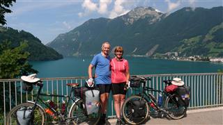
It was time to pose with our full Icebreaker kit on in front of the St Gotthard Pass sign.

Descending the other side of the Gotthard Pass is another, longer section of old cobbled road, dropping down round many hairpins through a beautiful valley, marred only by the new road built along its upper slopes. There were even more cyclists ascending in this direction which appeared much more arduous than the one we had come from.

With the St. Gotthard Pass dissapearing behind us, our plan was to stop at Biasca which our map showed had a campsite. Tourist Information told us the nearest one was 15km further down the
valley at Claro. Luckily it was mainly gentle downhill all the way so it
didn't take long. It was the most expensive site yet at 42 CHF for a
pitch. It did have a swimming pool but we were too tired to bother with a
swim.
Pitching the tent near the hedge we thought we would get some shade but
overnight we were invaded by slugs.They were all over the inner tent and
groundsheet and when Karen put on her cycling gloves there was one
there too.Ugh!
Gotthard Pass - Day 7 - Claro to Agno
- Distance 45km
- Max Elavation 642m

Gotthard Pass - Claro to Agno Ride Profile
Ride Description
For some reason today we had great difficulty navigating our way along
the cycle route. We went wrong at least four times. The last was due to
the absence of an important left turn sign and we went about 3km too far
along the road before realising. It was only thanks to the sat nav that
we got back onto the route.
It was hot again, about 30 C, and just before lunch there was another
10% climb, 340m in 6km. Just climbing from the centre of town back to
the road nearly killed us. Except for one short section, the whole
climb was in the full sun and very hot. Once we had crested the hill,
we rested in the shade and ate some food.
From there the cycle path followed the river along mostly unsurfaced tracks. Sometimes the route was closed due to roadworks and we had to navigate our way round the obstacles and find it again.
The campsite at Agno managed to exceed last night's record fee,
charging 43 CHF a night. It was on the shores of Lake Lugano and we
were able to cool off with a swim in the lovely clean water.
Gotthard Pass - Day 8 - Agno to Como
- Distance 38km
- Max Elevation 307m

Gotthard Pass - Day 8 - Agno to Como Ride Profile
Ride Description
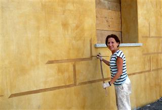
This last section of the cycle route follows the lake shore along its east side. There are many more houses and development here in the south. At the southern end of the lake we rode through the village and saw a lady, Moira, painting the exterior of a house with a 3D stone effect. She reminded us of our friend Krystyna, so we took a photo.
The official end of the cycle route is at Chiasso and we treated
ourselves to lunch so that we could spend our last 50 francs. We had
expected more of an experience crossing the border into Italy, but as it
was we just passed through with hardly any recognition at all. It was a
long slow and hot climb over the hill before dropping steeply down into
Como town.
Before we could continue we had to find some information about the
Italian cycle routes and get a map. Tourist Information was hidden away
in a square with no signage and only an inconspicuous front. Inside
there were no leaflets or information on display, everything had to be
accessed through the lady behind the counter. She was little help with
cycle routes and had no useful maps. She sent us off to the bookshop for
maps. Here they had maps of Wales, Northern England and France but not
for North East Italy.
As there were no campsites near we decided to book into a cheap hotel.
The one-way road system in Como took some navigating, with all the roads
in the direction we needed to go in being 'no entry'. The first place
we tried was full but the next had a quiet room at the back, on the
ground floor so no need to heave the bags up the stairs.
The next stage of our ride across Europe took us through the Italian Lakes, and Venice to Trieste and the border with Solvenia.
New! Comments
Have your say about what you just read! Leave me a comment in the box below.