Cycling the Pacific Coast -
San Francisco to Los Angeles
The Pacific Coast ride down the west coast of the US is one of the all time classic touring routes. We had a quick stopover in the US on our way to New Zealand so took the opportunity to ride part of this route, from San Francisco to Los Angeles.
Schedule
- San Francisco to Half Moon Bay
- Half Moon Bay to Butano State Park
- Butano to New Brighton Beach
- New Brighton to Sunset Beach
- Sunset Beach to Monterey
- Monterey to Pfeiffer Big Sur State Park
- Pfeiffer Bug Sur State Park to Plaskett Creek
- Plaskett Creek State Park to Hearst San Simeon
- Hearst San Simeon State Park to Cambria
- Cambria to Morro Bay
- Morro Bay to Oceano Dunes Beach
- Oceano to Lompoc
- Lompoc to Buelton
- Buelton to Refugio State Beach
- Refugio State Beach to Santa Barbara
- Santa Barbara to Carpinteria State Beach
- Carpinteria State Beach to Lake Casitas County Park
- Lake Casitas County Park to Lake Piru County Park
- Lake Piru to Santa Clarita
- Los Angeles
Our ride descriptions give an account of the ride that we completed. As part of the description we also provide links to Wikiloc or Google maps and elevation profiles based on mapping data available through the internet. The ride profiles are smoothed to give what in our opinion is a more beneficial view of the profile. We use paper maps, GPS and on line data to plan and conduct our rides. We are happy for you to use our descriptions, but be aware that we do not guarantee the accuracy of the information provided as situations surrounding any ride change over time.
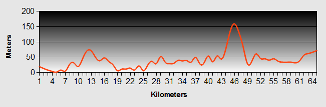
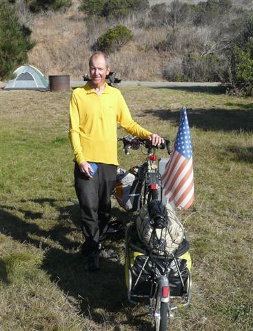
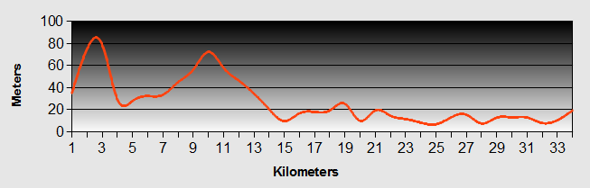
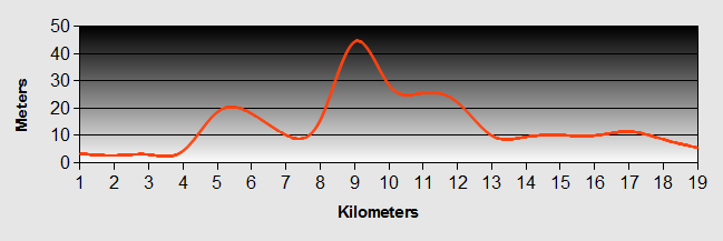
Pacific Coast - Day 1 - San Francisco to Half Moon Bay
- Distance 55km
- Max Elevation 210m
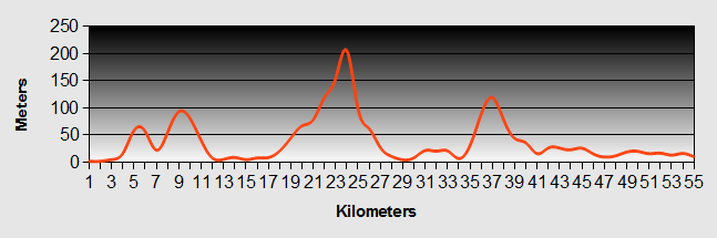
Pacific Coast - San Francisco to Half Moon Bay Ride Profile
Ride Description
As we rose for our ride along the Pacific Coast from Fort Mason, the bay was shrouded in mist. The Golden Gate bridge didn't exist. The bay cycle route turned up under the highway through roadworks with the inevitable "cycle route diverted sign" followed by a total void of information thereafter. We asked directions a couple of times and eventually found the correct route. At the top of the hill the fog was even thicker and wetter and what should have been lovely views of the Pacific Coast where simply replaced with sound effects of the waves crashing on the rocks below.
The fog was so dense that it wasn't worthwhile taking photos of the impressive "Legion of Honour" memorial. We dressed in our hi viz jackets and put on our lights. Fortunately the roads were residential and not at all busy. Descending the hill towards the Pacific Coast we stopped at Louis' cafe for the full breakfast with that lovely crispy American bacon and as much coffee as we could drink. This place was privately run and had been serving food since 1937.
We passed the San Francisco State Park and zoo and came onto California Highway 1 that winds its way alongthe Pacific Coast. It was busy, but had a broad hard shoulder. The fog was starting to clear a little.
Along the Pacific Coast highway we stopped at a gas station to buy petrol for our stove. As we were filling up a SFP squad car drew up. The policeman sidled over and Steve though he was in for trouble, but he just wanted to know if the fuel was to power the bikes, (duh!)
We bought burritos for lunch at a small Mexican take-out place next door to the gas station.
At the end of the bike lane on 1 we asked the way in a hardware store. The only way was to continue on 1 up a lengthy hill, locally known as Devil's slide. It was a narrow and busy hill with no hard shoulder. The advice of the guy in the shop was to take a taxi to the next town. We were made of sterner stuff and we carried on.
As we climbed the hill some geezer asked of Karen if she was on a single speed bike. She assured him that she had fourteen of 'em.
We dropped down the other side and continued along the side roads to Half Moon Bay where we sat and gorged ourselves with our lunch. What was left went to feed the seagulls. We didn't know if there was a camp site near by and enquired at a motel about accommodation. At $128+tax we cycled on.
The Pacific Coast route then went onto a lovely cycle track through the sand dunes and suddenly we found ourselves at the Half Moon Bay State Park Campground. Here we discovered "hike and bike" sections specially set aside for short stay (2 nights max) travelers. It was a good job, because the cost of a basic camp site was $35! If you had an RV with full hook up it was $50! Talk about trying to put people off. The H and B sites were only $5 per person per night.
Pacific Coast - Day 2 - Half Moon Bay to Butano State Park
- Distance 42km
- Max Elevation 140m

Pacific Coast - Half Moon Bay to Butano State Park Ride Profile
Ride Description
Awoke to wet drizzle and fog. The tent was soaked inside and out. Got an early start and tried to carry on along the Pacific Coast cycle way along the cliff top. It looked promising, but gradually deteriorated into a single track footpath. Getting over our fears of it going nowhere we tracked inland to get over an intervening gully and got back onto the Pacific Coast Highway.
We hadn't been back on the highway for more than 3 minutes when Steve realised he had a puncture. Our well oiled repair procedure kicked in and we were soon back on our way.
For the next 30km we continued on Highway 1 which was very up and down and busy with weekend traffic. American traffic mainly seems to adhere to the speed limit and we saw many "speed Controlled by Radar" signs and a few unmarked police cars. When we saw a sign saying "Speed Controlled by Aircraft", we had visions of Tom Cruise in his F15 flying low along the Pacific Coast shooting up anything that went over the limit.

We were suffering from our first long day in a while. The weather was overcast but warm. Couldn't find a cafe or any other outlet along the way. Finally we gave up, stopped to brew up and ate what we had.
We needed provisions and the first place we came to was the town of Pescadero that was two miles inland from the Pacific Coast.
It was a nice homely little town with two good general stores which also served food. We had a decent lunch stocked up and also discovered that there was a camp ground further down the valley at Butano State Park.
When we arrived the campground was full. We pleaded with the young female park officer who rang her supervisor and they agreed to let us camp on their picnic ground after 7-00pm for the hike and bike rate.
As we were the only ones there it was very quiet.
Pacific Coast - Day 3 - Butano to New Brighton Beach
- Distance 65km
- Max Elevation 140m
Pacific Coast - Butano to New Brighton Beach Ride Profile
Ride Description
We had to clear the site early. There was no fog and we rode up through the canyon to see the massive redwood trees. Then it was off up the Gazos creek on a nice quiet road to rejoin the Pacific Coast route.
It was less hilly today, just gentle rolling countryside; lots of cliffs and rocks with sandy beaches.
We stopped at a pick your own strawberry farm with its sign offering coffee at a discount for cyclists. We called in and opted for a strawberry short cake with cream. They had NO coffee as they had run out and only had some "festive tea thing". Still, it was well received.
At this point we have to mention that Steve had been having problems with his bell/compass. The bell wouldn't ding and in trying to fix it he had snapped the ball compass off its mounting. Painful!
He had now managed to fix the bell but still complained "My bell's ringing, but I've got no direction". Karen thought that this was akin to "the light's on but there's nobody home".
 A Thief In The Night
Shortly after this we stopped at a small hamlet to go to an ATM. As we arrived there were two cyclists just going into a cafe and we joined them for more food. They were a little older than us and were both keen tri-athletes. They had already done a swim that morning before their ride. Kathy had traveled extensively in all areas of the World by bicycle and was keen to share her experience with us. We swapped email addresses and said our goodbyes.
We came into Santa Cruz along the West Cliff promenade. As it was Sunday the sea front was thronged with healthy Americans cycling, skating, mono-cycling, jogging, surfing and playing beach volleyball (Steve's favourite as long as it's girls in 'only just there' bikinis).
We stopped to watch the surfers by the small lighthouse and got into conversation with a lady who hailed from New Zealand but had lived for the last 32 years in Santa Cruz. She warned us about how bad the weather can be in Wellington where she was born.
Further along the prom we stopped for beers and Steve was able to watch more beach volleyball. The town reminded us of an up-market Blackpool with it's numerous bars and restaurants and the large beach front amusement park with roller coasters and other adrenalin pumping rides. To get out of the bay the Pacific Coast cycle track went across the river on a narrow footbridge next to the railway track. Halfway across we met a group of Americans with a huge double width baby buggy. The only way for us to pass was to remove the panniers from the bikes and lift everything over the buggy.
The camp ground at New Brighton Beach was set on the cliff top at the top of a steep hill. After we had eaten our supper we rushed off to get a photo of the setting sun over the sea.
When we returned to the tent we discovered we had been raided by a raccoon who had tried to steal our breakfast granola and nuts. He was hiding in the tree above the tent with a guilty look on his face and there was granola all over the ground below him. We quickly stashed all the rest of the food in the secure food locker and he slunk off to search elsewhere.
Pacific Coast - Day 4 - New Brighton to Sunset Beach
- Distance 22km
- Max Elevation 65 m
Pacific Coast - New Brighton to Sunset Beach Ride Profile
Ride Description
We decided not to go all the way to Monteray today and opted to have a short ride. As we left the camp site a sign advised that the Pacific Coast bike route was closed and the diversion was very poorly signed. We ended up riding along the beach at Alto Apos, a sleepy seaside resort comprising mostly of vacation apartments. It was a dead end and we had to turn around and climb a very steep hill back out of the town to get us back onto the advised Pacific Coast route. Again we struggled to find somewhere we could buy groceries. At the turn off for Morensa State Beach we stopped to ask a passing motorist. He tried to use his I-phone to find us a grocery store without success. (modern technology ain't all it is cracked up to be).
Along the road was found a camp ground with a poorly stocked general store, but managed to find enough for an evening meal. We headed back to the Morensa camp ground only to find that they didn't have a hike and bike section.
We were now into another intensive market gardening area, with fields of strawberries, artichokes, brussel sprouts and cabbage. Just as we were about to turn off to Sunset bay, the fog started to roll in and the previously beautiful day was lost. We had the camp site to ourselves and we pitched right next to one of the fields - (forever). The temptation to steal a few was intense.
 Sunset Beach
After we had pitched, the sky cleared again and we walked down to lie on the deserted beach. We stayed until dusk and watched, amazed as hundreds of gulls flew in from all around to roost on the beach. They lined themselves up on final approach, like 747s coming in to land at Heathrow.
As we climbed back up the sand dunes to get a better view of the sunset, a group of lads asked us to take a photo of them. They then ran down the steps, across the beach scattering the roosting birds in all directions, stripped down to their duds and dived into the freezing cold Pacific.
After the obligatory sunset photos...
 Sunset at Sunset Beach
...we returned to shower and cook our supper.
 Fine Dining at Sunset Beach
Pacific Coast - Day 5 - Sunset Beach to Monterey
- Distance 51km
- Max Elevation 55m
Pacific Coast - Sunset Beach to Monterey Ride Profile
Ride Description
The next morning we continued our Pacific Coast ride through the intensive farming area, with huge field after field of fruit and veg, which employed large numbers of mainly Mexican workers.
Finally the Pacific Coast route came back onto 1 which was busy and noisy with lots of lorries. Although there was a wide hard shoulder, this section was boring and unpleasant.
Suddenly, a sign advised us that we were coming to a Freeway ( the UK equivalent of a Motorway). We couldn't see any other way ahead and stopped to ask a Mexican worker in the fields. He told us to continue along the Freeway until the first exit. We pedaled like maniacs along the hard shoulder with three lanes of fast moving traffic, convinced that we were breaking the law and about to be arrested by the police. When we reached the first exit a sign said " No Bicycles beyond this point", so it was obviously part of the official Pacific Coast route, but the signs didn't give much indication of that.
From there we traveled on quite side roads and then onto a well surfaced Pacific Coast cycle track parallel to the Freeway, all the way into Monterey. The rough ground around the cycleway was a warren of ground squirrels that kept doing a kamikaze dashes in front of our wheels.
Approaching Monterey we had lovely views across the beach to the Pacific Coast headland. The Fisherman's Wharf on the outskirts of the town looked inviting with lots of restaurants and shops. We locked up the bikes and had a delicious homemade pasta lunch. Afterwards we walked along the wharf to see the resident sea lions and pelicans.
 Sealions in Monterey Harbour
Karen had left her brand new North Face fleece top under the bungee cord on the bike of her bike and whilst we had our backs turned someone made off with it. Grrrrr!
Checked into the Hostel on Hawthorne Street for two nights as we needed to get hair cuts, get our computer fixed and find a new fleece top.
Day Off
Monterey is a lovely Pacific Coast resort town that originally made its living from whaling and later catching and canning sardines, but they fished the stocks to extinction by the early 1960s. Now the canning factories have been converted to gift shops, stores and restaurants catering to the tourist trade. The town has a nice ambience and is very bike friendly.
The hostel was homely and the staff were very friendly. There was a large sitting room and well stocked kitchen. One member of staff would entertain us with classical and popular piano. Breakfasts were pancakes and waffles for just a donation of 50cents.
We cycled to the suburb of "Seaside" to buy a fleece for Karen but ended up coming back to Joselyn's Cycle shop. She got a nice girly pink one.
Took the computer to be fixed twice, but not a lot of success. $50 later we still have a dodgy computer.
The haircut was an experience. We found a place run by two Spanish ladies of a certain age. There were no customers (should have rung alarm bells). Karen had a first when both ladies set about (being the operative words) her hair at the same time. One then broke off to give Steve a good going over! Still, that's traveling for you!
Duties completed we rode the 17 mile drive around the Monteray, Pacific Coast headland, passing through and between seven different golf courses the most famous probably being Pebble Beach.
Stopped at the Fish Wife cafe for a delicious lunch of Clam Chowder and Seafood Pancake.
Although the Pacific Coast ride was lovely it was spoilt a little by a lot of traffic and tourists at each view point.
 Ghost Tree
 Lone Pine
 Rock Piles
The last part took us up a steep hill through the park ,which still had cypress trees that were over 1000 years old. In a country that has only existed as a united nation for less than 300 years, this is real history.
We got back onto highway 68 in rush hour. It was busy, narrow and steep. We were glad to get off the 68 and onto Prescott (not John) to take us back to the hostel. One part of this was about a 33% incline.
That evening a young guy arrived at the hostel. He was a cocky, curly haired guy that we didn't initially take to. He boasted about having ridden from Half Moon Bay to Monterey in one day approx 100 miles. As we sat reading in the lounge he fell asleep and was still asleep when everyone had cleared off to bed. Don't know what time he actually got into his bunk, but it was late or even early morning. When we left the following morning he was only just eating his breakfast.
Pacific Coast - Day 6 - Monterey to Pfeiffer Big Sur State Park
- Distance 65km
- Max Elevation 160m
Pacific Coast - Monterey to Pfeiffer Big Sur State Park Ride Profile
Ride Description
After yesterday's Pacific Coast ride we knew that we didn't want to take the route up the busy 68 hill. Instead we found a way across the Monterey headland between the golf courses coming onto the Carmel Beach road at Pebble Beach.
Carmel Bay was beautiful with a long curving beach of almost white sand. Along the seafront were houses demonstrating the imaginative flair of American design uninhibited by strict planning rules. There were Scottish castles, fairy tale cottages and other such grossly over the top concoctions.
 Carmel Beach
As we left Carmel we stopped at Carmel mission. When California was a Spanish colony Christianity was brought by the Spanish to the local native indian community.
 Carmel Mission
Rejoining highway 1 we stopped at "Safeways" to buy supplies. While Karen was shopping Steve met a Mexican couple cycling the coast on recumbent bikes and was befriended by a gentleman of the road from Baltimore that carried a pair of drumsticks and a bag (but no drums). He lectured Steve on the ins and outs of how they had beaten the British prior to the civil war. Was he glad when Karen came out of the shop and got us back under way.
From here it was a gradual climb up towards Big Sur. We stopped at a vista point (view point to us British types) and dragged our bikes through a few feet of scrub to sit on the cliff top overlooking the sea to eat our lunch and have a brew up. It was perfectly quiet when we arrived, but by the time the stove was going a large group of motorcyclists had arrived and come over to our private little spot to take photos of the view. This was repeated again after a few minutes when a couple of cars stopped and their occupants all came across. Then a familiar face appeared. It was the young guy from the Hostel the night before. He seemed to want some company so he sat and ate lunch with us and we introduced him to real English teas with milk in it. He seemed to quite enjoy it and informed us that his name was Beamer.
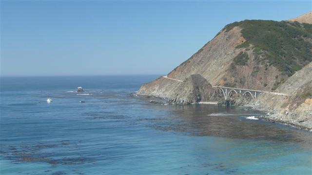
Thereafter the Pacific Coast route was an up and down road and we had fabulous views across the bay to the Point Sur lighthouse followed by a fast downhill and a long flat section before rising up slightly again as we came into Big Sur and saw Beamer sitting at a bar with beer in his hand. We had to join him.
 Point Sur
We camped at Pfeiffer Bug Sur state park under the massive redwood trees and met seven other cyclists all doing the Pacific Coast Route. One of them, Bob, was a 60 year old, interior painter and decorator from North Dakota and he had cycled all the way from his home, some 90 days. He was towing his gear in, appropriately, a Bob trailer. We were just surprised he hadn't nicknamed his bike Bob as well.
We were also joined by a couple of young, attractive young ladies who were traveling from New Mexico to Oregon with huge back backs. We thought they were walking but they admitted that most of it was hitching lifts.
After supper we all sat around the camp fire chatting until it was time to retire.
Pacific Coast - Day 7 - Pfeiffer Bug Sur State Park to Plaskett Creek
- Distance 55km
- Max Elevation 280m
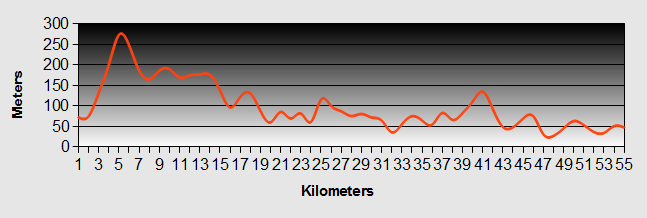
Pacific Coast - Pfeiffer Bug Sur State Park to Plaskett Creek Ride Profile
Ride Description
Before we set off south we went back 3km to Big Sur to buy provisions as we were unsure if there would be any more places to buy food. Carrying on again past the camp site there was a long climb which was hard going first thing in the morning. As Murphy's law would dictate, at the top of the hill was a store.
As we slogged up the hill we were passed by Beamer who had his sights set on getting to San Louis Obispo as he wanted to go to a swing dance (his other hobby). Our aspirations were much more modest.
 The Big Sur
On the way down the other side of the hill we stropped at the Henry Miller Gallery to look at some amazing art and for a coffee and Burito. The road was very busy with weekend holiday makers. It seemed to us there were only four types of vehicle on this part of Pacific Coast highway SUVs, Rvs (towing SUVs), sports cars and Harley Davison motorbikes.
The whole day was spectacular riding with fantastic views down to the Pacific Coast on our right and precipitous mountains and forest rising on the left. The sun shone strongly and it was very hot when we were high up, but whenever the road dropped back near sea level we picked up the cooling on-shore breeze.
We repeatedly crossed narrow canyons dropping down to cross them over concrete bridges built during the 1930s and then climbing again up the other side. There were not many trees to find shade to eat our lunch and finally stopped at Lucia under a tree.
The afternoon consisted of countless photos as each view surpassed the last.
All of the camp grounds that we passed along the way were full which surprised us this late in the season.
We camped at Plaskett Creek State Park which was full with masses of American families, lots of kids and quite noisy. It turned out that there were no showers and no potable water; just four toilets for the whole camp site.
Bob arrived shortly after us and another male cyclist was also camped there.
Once pitched we rode into Gorda to find food. We found the Whale Watchers Cafe. As it was already 6pm we were anxious to get back to the site before it got dark at 7-15. We were greeted by the American bar man like we were old friends. He told us that they could do anything on the menu "to go" and offered us a beer on the house while we waited. He was just finishing his shift so handed us over to Chinese waiter called Gilbert, who took our order. Next out came the chef who was a big round faced, jolly, Basque guy. He proceeded to serenade us whilst our food was cooked. We ordered a second beer and were persuaded to have a third, so that by the time our "surf and turf" was ready we hardly noticed the ride back as the sunset.
There was so much food that we shared it with the guys back at the site including two American ladies who had also pitched on the hike and bike site as there was no room on the main site.
They provided the fire wood and we again sat around chatting before retiring to bed.
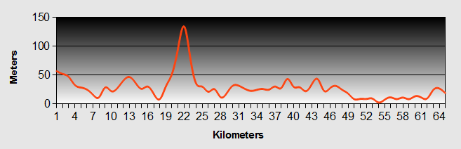
Pacific Coast - Day 8 - Plaskett Creek State Park to Hearst San Simeon
- Distance 52km
- Max Elevation 230m
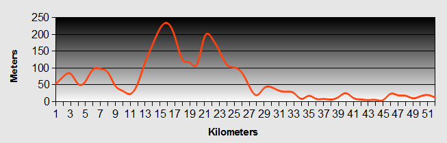
Pacific Coast - Plaskett Creek State Park to Hearst San Simeon Ride Profile
Ride Description
Our shared hospitality the night before paid off when the two American ladies paid our camp fees for us.
With clear blue skies and no wind we were set for a hot day. We cycled 5km to the Whale Watchers Cafe for breakfast. Bob was already there so we sat with him. We were soon joined by two more ageing touring cyclists, so we all ate together.
Breakfast over, it was 10-30am and we had a 1000ft climb out of Gorda followed by a fast downhill and another steep ascent.
After a few more minor hills we stopped for further refreshment before beginning a long gradual descent back to sea level. We were flying along when a group of people hailed us from a truck in a lay-by. They were the support team for a 100 mile road cycle race from San Lous Obispo to the Pedras Blancas Lighthouse and back again. They gave us bananas, apples and water as well as advice to call and see the Elephant Seals further along the road.
As instructed we stopped when we saw the tourists looking over the fence. This is where Elephant Seals come to give birth in the spring and to rest in the autumn. The beach was littered with row on row of pale seal bodies looking somewhat like sunbathers on the Spanish Costas.
 Basking Seals
We moved on from the tourists and only 200 meters up the road we spotted another small beach with no tourists and got much better views of juvenile male seals sparring in the water.
 Sparring Seals
We were now cycling passed Hearst Castle and decided against spending $27 to view it and instead diverted into San Simeon and ate a Hearst Beef Burger at a wee cafe.
 San Simeon Wharfe
As we covered the last 5km to the camp site we were amazed to see Zebra grazing in the fields with the cattle.
 Zebra
ZebraThe hike and bike section of San Simeon camp ground was right next to the Pacific Coast highway. It was cold at sun set so we were in bed by 9-00pm, just as a couple arrived to pitch up. They spent the next hour or so banging about and making a lot of noise before eventually settling down. Finally we got some sleep!
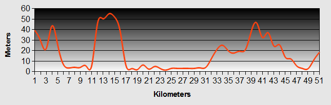
Pacific Coast - Day 9 - Hearst San Simeon State Park to Cambria
- Distance 3km
Ride Description
At 6am the couple next door started packing up again. It seemed hardly worth the $35 for 9 hours camping.
As we packed we said our sad goodbyes to Bob who we had camped and traveled with for the last three days.
We planned to only go three miles to Cambria so spent the morning doing odd jobs. The washing we had done the night before just would not dry despite hanging on a line in full sun with a stiff breeze, the high humidity meant that it just stayed wet. Finally it was packed damp.
The hostel at Cambria had been recommended to us and we needed time on the Internet. Obviously the ride did not take long so we bought some lunch and then went to sit on the beach in the warm sunshine. Here we met Fred who would become a constant companion as we traveled down the Pacific Coast. Always appearing just as food was brought out he would wait patiently for any tasty morsels that were on offer.
 Fred The Seagull
The hostel had the feel of a small family home.
 Cambria Hostel
After cooking and eating our dinner we sat with the other guests around the table swapping stories. Here we met Marianne Cantwell, who was vigorously working on her laptop. Marianne makes a good living from presenting on line coaching to people to help them free themselves from the day to day drudge of work and follow a career or lifestyle that they previously only dreamed of. You can see her web site at http://www.free-range-humans.com
Pacific Coast - Day 10 - Cambria to Morro Bay
- Distance 34km
- Max Elevation 83m
Pacific Coast - Cambria to Morro Bay Ride Profile
Ride Description
The road from Cambria moves away from the Pacific Coast. It was a steady up hill into a strong and hot head wind. The temperature was rising rapidly and our legs felt like they were frying. Arriving at the north end of Morro Bay the road cuts north east along the top of the bay to the small Pacific Coast town of Cayucos. We had to find shelter from the incredible heat. Even the locals were complaining about how hot it was.
We stopped at a cafe with air conditioning and downed gallons of iced water, before we could even summon the energy to order food. The thermometer on the shaded patio read 37 deg C (100 deg F).
Fed and watered we continued our journey in the intense heat. Suddenly at around 12-30 we dropped down to sea level and caught a blast of wonderful cooling sea breeze. It was like someone had just turned on the air conditioning.
Morro Bay is a lively town on an estuary with a beautiful, natural harbour spoilt only by a power station at one end of the bay.
 Morro Bay
We shopped at Albertson's and Steve came out chuffed to death as he had bought a bargain load of Dover Sole fillets for $3.83, but was shocked by the total bill - $76. However neither he nor Karen queried it at the time.
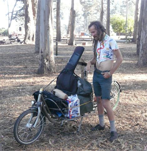
The Morro Bay state park camp ground is in a great setting by the golf course and minutes from the estuary. There were eleven other cyclists staying there that night. We met a young guy with dreadlocks on a most unusual bike. Unfortunately we didn't get his name.
It was peaceful and we both had the best nights sleep camping for some time.
 Morro Bay Estuary
Day Off
Day off - Steve was still wondering why the shopping bill yesterday was so high. He rechecked the till receipt and found that instead on $3.83 cost for the fish he had actually been charged $38.3, hefty price for a bit of sole! The shop refunded the difference. The rest of the morning was spent shopping in the town and later we rode around the estuary. There we sat on the side of the water watching the marvelous air display of the pelicans diving bombing to catch fish and the smaller birds all getting in on the act to salvage the leftovers.
There were hundreds of pelicans in the bay. At night they roosted on dredging barge close to the shore. There were two types of breed, grey and white. We learnt that the two types hunt for fish in very different ways. The grey ones fly up and dive down into the water to scoop up the fish. The white ones form large groups and work cooperatively, wading in the water to herd the fish onto the shallows where they can catch them more easily.
 Pelican Boat
Pacific Coast - Day 11 - Morro Bay to Oceano Dunes Beach
- Distance 37km
- Max Elevation 52m
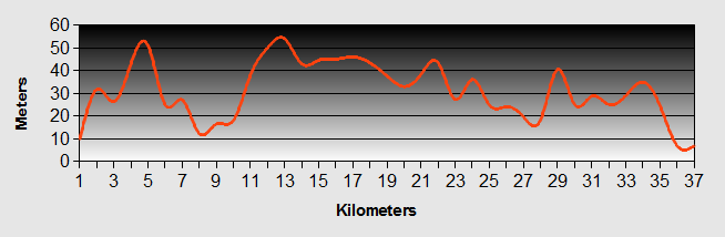
Pacific Coast - Morro Bay to Oceano Dunes Beach Ride Profile
Ride Description
Today's Pacific Coast route was entirely on the hard shoulder of H1. Most of the traffic was on the freeway which made the road relatively quiet. It was mostly flat with a few gentle rolls and we made good time to San Louis Obispo. We had to stop here to find an outdoor shop to buy new head torches as both of ours had spontaneously fallen to pieces when we tried to change the batteries.
After shopping, we found a cafe for an early lunch. A couple of cyclists taking part in a sponsored Pacific Coast ride from San Francisco to LA came in and chatted briefly with us.
From then on we kept being passed by groups of cyclists on the same Pacific Coast ride. They were all on road bikes with their gear being transported by their support team, so they could travel much faster than us.
It was cooler today, but the Pacific Coast ride was uneventful and Pacific Coast terrain / countryside was a bit boring.
We planned to camp at Oceano which, according to the State Parks information, had a hike and bike section. However, when we arrived we were told that it had been discontinued. Fortunately, the Arthritis Association bike ride folk were all camping there en-mass and we managed to blend in with them.
As we were cooking dinner, a young and attractive female cyclist turned up. She was also gate crashing the event and she sat and chatted with us. She had no tent only a bivvy bag. So she just parked her bike where she was going to sleep, next to our tent. Lilly, for that was her name, told us that she had quit her job and was cycling around the US, currently on her way to see a friend in Santa Barbara. Interestingly, she was expecting to get a job working on a Marijuana farm, which is legal for medicinal purposes in California. It made for an interesting evening.
At about 8-00pm one of the cyclists, who was also an operas singer gave a rendition of some opera favourites. She was very good.
And, although the site was crowded with tents, everyone was in bed by 9ish, so we had a good nights sleep.
Pacific Coast - Day 12 - Oceano to Lompoc
- Distance 73km
- Max Elevation 180m
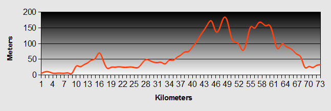
Pacific Coast - Oceano to Lompoc Ride Profile
Ride Description
The cyclists were getting up by 6-30 am and packing their tents, so we had an early start and were away by 8-30am.
The sponsored cycle ride took a slightly different route, but we all started off the same way. Of course everyone was passing us, even the veterans, but we did our best to keep up.
We arrived in the first town of Guadalupe and it was as if we were in the middle of Mexico. It was a predominantly Spanish speaking one road town with a rail road running next to it. Only Mexican food available an the usual surly Spanish service that goes with it. Stopped in a cafe for a burrito and a coffee and met Johnny. He wore a fancy cowboy shirt, Stetson, boots etc, but no gun.
The whole of the Pacific Coast ride was along highway 1 which went from normal two way road to dual carriage way to freeway. It was very busy, but had a wide hard shoulder. Initially flat with large market garden fields with intensive Mexican labour. Later we had to cycle four miles along the freeway. After this it went back to dual carriage way, which climbed up three long hills. It was very hot and exhausting as the sun reflected back from the road surface.
At the top of the last hill was the Vandenberg Air Force base where the train the astronauts for the space missions.
Arrived in to Lompoc and checked into the No 6 motel which was good value at $50.
Had a swim and saw a hummingbird.
Pacific Coast - Day 13 - Lompoc to Buelton
- Distance 33km
- Max Elevation 150m
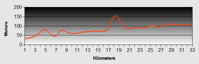
Pacific Coast - Lompoc to Buelton Ride Profile
Ride Description
We got up late and spent a long time looking for accommodation on line. As it was weekend everywhere was booked up in the town we wanted to stay in Solvang so we booked into the No 6 at Buellton.
Left Lompoc on highway 1 towards Santa Barbara and took the first left on a minor road along the Santa Ynez valley. It was a relief to be on a quiet road. It is an important agricultural area growing vegetables and grapes for wine production., We rode through walnut groves and home oaks.
Buellton was a nowhere place, by the side of the Freeway. Very Mexican. We went for a meal at the reputed Pea Soup Anderson's restaurant. We were under whelmed.
Saturday was a day off so we worked on the blog as well as talking with relatives on Skype.
In the afternoon we rode 3 miles to Solvang, the Danish capital of America. It is a pretty , wooden town although the Americans call it a city. We were a bit disappointed as it seemed very false. A bit like a Disney World film set. Typical Danish style buildings and windmills for no other reason than to build the illusion.
The most authentic thing was the town museum which was in a house built decorated by a Danish artist couple in the 1950s. It had exhibits of their art and historic records of the town and its development. It was run by three senior lady volunteers who were very keen to share their extensive knowledge of the area and history of the exhibits.
 Street Car in Solvang
We were the only visitors there while the false part of the town was heaving with tourists all apparently fascinated by the place.
When we got back that evening we saw on the TV that the East Coast had experienced bad rains and flooding. For once the bad weather missed us.
In the evening we walked down the road to AJ Spurs a traditional steak bar. AS per normal American style the portions were huge so we shared a 12oz Sirloin. The biggest steak on the menu was a 36oz one. Anybody that could eat it all got a free T shirt. XXX Large style we presume
Pacific Coast - Day 14 - Buelton to Refugio State Beach
- Distance 45km
- Max Elevation 280m
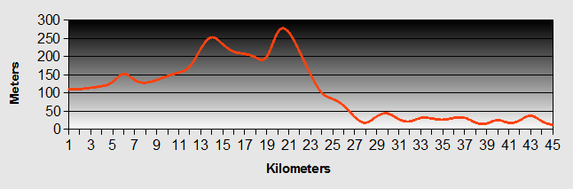
Pacific Coast - Buelton to Refugio State Beach Ride Profile
Ride Description
The ladies in the Sovang museum had told us about Alisal Road, a lovely back road that went out of Solvang and about 6km through the valley to join the Highway 101 and our Pacific Coast route further along.
 Alisal Road
It saved us some tortuous climbing up the 101 and it was such a treat to cycle along this British style lane in the shade of the huge Home Oaks and Maple Trees.
 Alisal Road
The low cloud spoiled some of the view to the top of the Santa Ynez mountains.
Cycling along we glanced down and spotted this huge tarantula at the side of the road crawling gingerly through the grass.
 Tarantula
Once we joined the Pacific Coast highway the elevation was at the base of the clouds so we donned our reflective waistcoats and switched on our lights.
Another section of three lane free way which some veteran cyclists had recommended to us in Preference to the Refugio road which would have taken us straight over the mountains, but was way to steep. Over the crest we had a two mile down hill all the way to Gaviota.
As we cycled along the Pacific Coast highway, Karen yelled out to Steve "Dolphins" and there they were jumping clean out of the water several times as they chased schools of fish.
At Refugio the camp price had doubled to 10$ per person and there were no shops or services, apart from a small store that sold nothing very useful at high prices. Spent nearly $70 on basic foods for our two day stay. A guy that was just vacating his camp site gave us a heap of firewood, so we had a cosy evening around the fire while we ate dinner. The compensation was that the hike and bike section was right on the beach so we could sit eating our meals watching the dolphins, seals, pelicans and terns all feasting on the abundant ocean fish.
 Refugio Bay Barby
The following day the previous day's low cloud had cleared so we decided to ride up the Refugio canyon road (without load). It was very steep and we could not have done it with a full load. We rode through avocado, lemon and walnut trees and as we got higher came into low scrub.
 View From Refugio Road
In the afternoon, for the first time in the US we lazed on the beach.
That evening a Swiss couple arrived. We had heard about them from other cyclists and we wondered if we would come across them or whether they were just a myth.
Pacific Coast - Day 15 - Refugio State Beach to Santa Barbara
- Distance 42km
- Max Elevation 62m
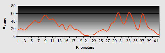
Pacific Coast - Refugio State Beach to Santa Barbara Ride Profile
Ride Description
It was a cool morning with high cloud and calm sea.
We chatted with Vreni an Ueli, who were around 60 ish and were basically done what we had done, but rented their house out instead of selling it. They had been cycling for 17 months and down 17000 km. We got the impression that they were wanting to go home, but their house was on three year lease. From Refugio they were heading on down to Mexico and then flying to Morocco before working their way back to Switzerland through Spain and France.
 Vreni and Ueli
The ride to Santa Barbara was pretty boring, along the freeway to Galota and then along a cycle path before coming to a cycle shop in Galota where Steve managed to get his gear shifter fixed which had rattled a screw loose. From we took the Pacific Coast cycle route which went through Hope Ranch, a famous area of Santa Barbara with expensive houses. Once in Santa Barbara the cycle path ran along the beach.
Booked into the cheapest accommodation we could find, the Tourist Hostel, just across the road from the train station. It was the worst accommodation we have stayed in so far. The walls were very thing and didn't stop noise from neighbouring rooms (say no more!) The mattress had a noisy plastic cover and the bed was uncomfortable. We were glad to be in any accommodation that night, as about an inch of rain fell.
After we had checked in Vreni and Ueli also arrived and after trying to find cheaper accommodation came back and checked also.
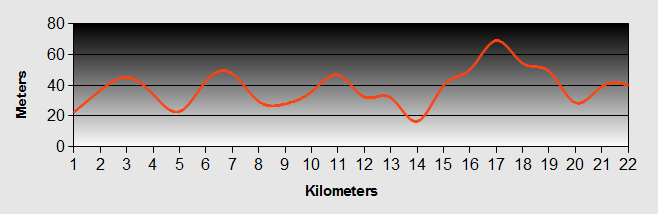
Pacific Coast - Day 16 - Santa Barbara to Carpinteria State Beach
- Distance 19km
- Max Elevation 44m
Pacific Coast - Santa Barbara to Carpinteria State Beach Ride Profile
Ride Description
Said goodbye to Vreni and Ueli as they were heading to Oxnard and spent the morning in an internet cafe dealing with emails and travel arrangements for New Zealand.
Later we took a brief bike tour of Santa Barbara which is a beautiful city with many old Spanish style buildings. Specifically the court house and the Santa Barbara Mission.
 Santa Barbara Court Building
 Santa Barbara Mission
 Santa Barbara Mission
 Santa Barbara
The Pacific Coast route from there was along quite suburban roads and cycle tracks all the way.
For the first time in America the campground was next to a good size town so there was easy access to shops, bars and restaurants. Just as we had pitched an other couple of cycle tourists arrived, Clare and David from Newcastle. They were on a six month trip from Seattle down to Mexico and Central America. Being 15 years our junior and on a definite time scale they were covering twice our daily distance. We met them in the bar later in the evening. They were good company and we were sorry not to be able to spend more time with them.
 David and Clare Robb
Pacific Coast - Day 17 - Carpinteria State Beach to Lake Casitas County Park
- Distance 28km
- Max Elevation 340m
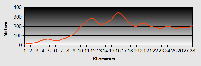
Pacific Coast - Carpinteria to Lake Casitas County Park Ride Profile
Ride Description
Today we left the Pacific Coast route and took highway 150 more or less due east, North of Venture. There were two good climbs, but the road was quiet and the scenery stunning with the surrounding peaks up to 2300m and large trees to shade us from the sun.
It is serious avocado country with most of the slope covered with avocado orchards. We learned that there at least six different types of avocados, all maturing at different times of the year, thus guaranteeing a year round supply.
 Lake Casitas
The camp ground on the shores of Lake Casitas was quiet with only a few Rvs. As it was only a short ride we had picked the tent by 2-00pm and we walked down to the lakeside cafe for a bear. It was closed and disappointed we walked back to the tent to make a "cuppa".
The camp host was very chatty and brought us some free wood for the fire and a couple of free Coronas. His name is Roger Moore!
 Lake Casitas
 Vulture
Pacific Coast - Day 18 - Lake Casitas County Park to Lake Piru County Park
- Distance 77km
- Max Elevation 440m
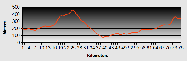
Pacific Coast - Lake Casitas to Lake Piru County Park Ride Profile
Ride Description
Continued along highway 150 through the grand mountains and valley plateaus. After 5 mails came to the town of Ojai and stopped for an egg and bacon breakfast.
As we set off a gain we were joined for a short time by an English cyclist, originally from Leicester who had moved to the US 21 years ago and California 18 years ago.
He stopped for an energy bar saying he would catch us up, but he never did. We must be fitter than we think.
 Ojai Valley
Only one serious climb today and we stopped at the Summit cafe, knowing that we had a good long hill from there into Santa Paula. Along the way we arrived at Sulphur Springs and saw the modern, Italian style, Thomas Aquinas College. As we headed down the valley we understood why Sulphur Springs had its name.
 Thomas Aquinas College
From Santa Paula it was all along the highway which was flat, but was very busy with a lot of large lorries. After brief stop at Fillmore for a McDonalds and some shopping we turned off up to Lake Piru. The road was poor and it was getting late. The road rose gradually until we reached the dam at which point the gradient increased dramatically so we were in 1, 2 and 3 gears most of the way.
Reaching the top we got wonderful views of the Lake in the setting sun.
 Lake Piru
We arrived at the campground at dusk. Time to pitch the tent before it got dark.
The next day we started to get ready for our transition to New Zealand. Cleaned and maintained our bikes, washed some clothes and finished off our final blog entry.
When we got back to our tent after a walk we found both of our back tyres were flat, but as it was getting to be dusk we decided to leave them till the next day.
Pacific Coast - Day 19 - Lake Piru to Santa Clarita
- Distance 42km
- Max Elevation 420m
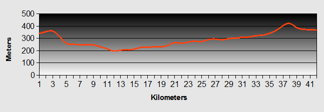
Pacific Coast - Lake Piru to Santa Clarita Ride Profile
Ride Description
The day we had intended to cycle from Lake Piru to Steve's nephew's place in Santa Clarita, north of LA, was supposed to be a laid back, easy going day.
We had a disturbed night due to the Mexicans camping close by, partying to 4-00am so we arose in not the best of moods.
Nevertheless we spent a relaxed morning washing down our kit in preparation for our flight to New Zealand. Steve set about fixing the punctures in the back tyres. Karen's tyre didn't present a problem. His own had a longitudinal slit adjacent to the valve. An awkward fix, so he fitted the spare tube. Having pumped it up to full pressure it popped and deflated rapidly. ***mn!
Removing it we found exactly the same type of slit. So we now had two bad tubes and no more spares. He tried to patch one of them and attempted to blow it up again. Pop goes another one. So then he re-adjusted the wheel tape and tried to patch the second tube. Carefully he pimped it back up again, making sure the tyre was properly seated and there were no pinches. Hiss! This one too was leaking. Then bizarrely Karen's back wheel went hiss, squeal and also deflated. Steve was in despair, not knowing what was causing these strange tube ruptures. There was nothing else we could do than ask a couple that we had met the day before and who lived in Santa Clarita if they could take us and our gear to the nearest bike shop, also in Santa Clarita.
We piled the bikes our gear and ourselves into Scott's SUV and headed off. He dropped us at Performance Cycles and wouldn't even let us pay him for his fuel let alone his time.
The guys at performance cycles fitted a new tube (although it was a Presta valve rather than Schrader) to Steve's bike and found that Karen's bike had a faulty valve.
With both bikes repaired we needed sustenance, so headed for the Starbuck's in the Barnes and Noble bookstore to find Sam's address.
Pacific Coast - Day 20 - Los Angeles
Coincidentally Sam's mum, Chris was in town on business and had invited us to use the spare room in her hotel suite near to LAX International Airport, before we flew to New Zealand. It was some 40 miles from Santa Clarita to El Segundo where she was staying. The easiest way to get there seemed to be by using the Metro.
So once we had packed up and loaded our equipment on the bikes we set off, stopping after a couple of hundred yards to post a letter. It was then we realised Karen's rear tyre was flat again and still we hand no spare tubes. We only had 40 minutes to catch our train!
A nearby shop owner Googled bike shops and found two. Steve unloaded his bike and set off at full speed. After a miles ride he found the first shop. It was closed! 300 meters further on the second shop was also closed!(today was Columbus Day in the US) Pulling his hair out he asked in another shop to see if there were any more bike shops. Told that there was another close by, he set off again following vague directions. Unable to locate it he asked a passer by who Googled it on his i-phone and called them to make sure they were open.
Steve finally returned with spare tubes in hand. By this time the train should have gone. Tyre repaired we casually rode to the station expecting a long wait. Fortunately the train was late and was just pulling into the station. The train attendant ran with Steve to the ticket machine and helped him buy the tickets and then it was a mad dash back to load the bikes onto the train. Phew!
Using the Metro worked really well and after three changes we arrived at El Segundo to find the hotel just 100 yards away where we checked in and freshened up.
That night Chris drove us the local Performance Cycles shop to get two bike boxes for shipping our bikes. They just fitted into the car with Karen and I huddling together on the bike seat.
She treated us to a tasty meal at a fish restaurant down by the wharf.
The following day was more or less consumed by preparing to fly.
We had to make several visits to the shops to get packing tape and stuff to wash and degrease the bikes with, as well as fitting in lunch.
The bikes needed dismantling substantially to get them to fit into the bike boxes, but finally we got everything into the box. Our bags were packed and we were ready to go.
We had booked a complimentary shuttle taxi to take us to the airport. With one last photo and quick goodbyes to Chris we were off.
New! Comments
Have your say about what you just read! Leave me a comment in the box below.