Cycle Melbourne to Adelaide
along the Great Ocean Road
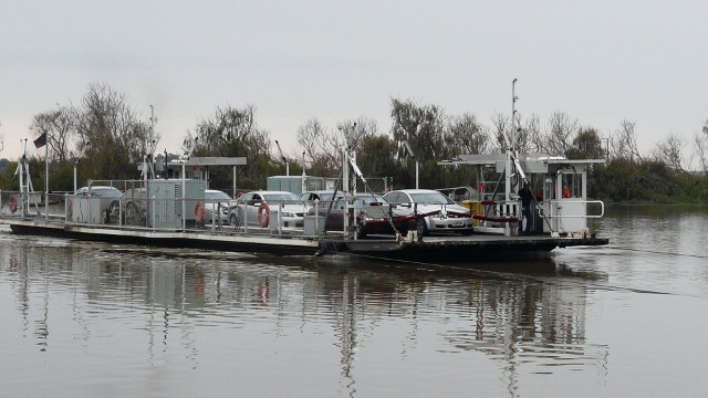
For the start of our ride from Melbourne to Adelaide we decided against the cycle route out of the city to the west, which runs through boring and busy industrial areas. Instead we took the train. Arriving at Southern Cross station, we found that the train had been canceled due to weekend maintenance works and was replaced with a bus. There is no guarantee that buses will take bikes, but as there were not many people on board it did not present any problem. The bus arrived in Geelong at 9-15am. We cycled down to the beach area and treated ourselves to eggs Benedict, fresh orange juice and coffee before the real start to our ride.
The ride took us 16 days with some additional time off days. No doubt it can easily be achieved in less time. If you haven't got the time or the stamina to cycle the route why not take one of the tours with Oz Experience.
Schedule
- Melbourne (train to Geelong) to Lorne
- Lorne to Apollo Bay
- Apollo Bay to Lavers Hill
- Lavers Hill to Port Campbell
- Port Campbell to Kilarney
- Kilarney to Portland
- Portland (car to Nelson) to Mount Gambier
- Mount Gambier to Millicent
- Millicent to Robe
- Robe to Kingston SE
- Kingston SE to 42 Mile Crossing
- 42 Mile Crossing to Meningie
- Meningie to Wellington
- Wellington to Strathalbyn
- Strathalbyn to McLaren Vale
- McLaren Vale to Adelaide
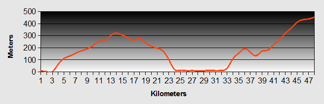
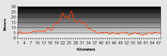
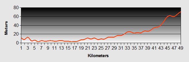
Our ride descriptions give an account of the ride that we completed. As part of the description we also provide links to Wikiloc or Google maps and elevation profiles based on mapping data available through the internet. The ride profiles are smoothed to give what in our opinion is a more beneficial view of the profile. We use paper maps, GPS and on line data to plan and conduct our rides. We are happy for you to use our descriptions, but be aware that we do not guarantee the accuracy of the information provided as situations surrounding any ride change over time.
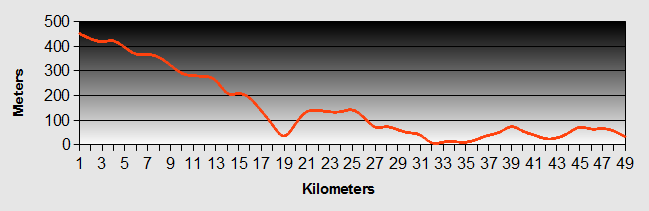
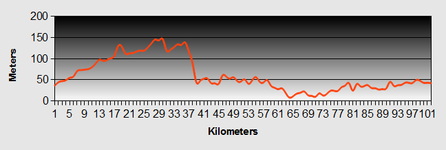
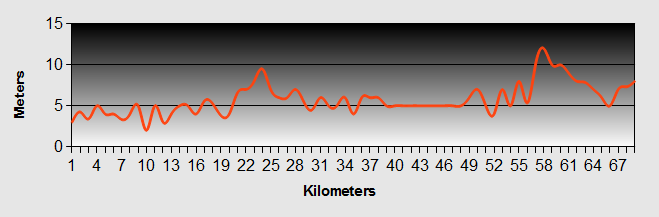
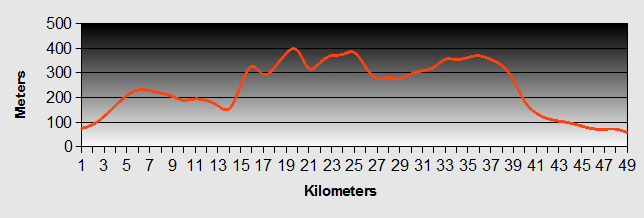
Melbourne to Adelaide - Day 1 - Melbourne (train to Geelong) to Lorne
- Distance 69km
- Max Elevation 120m
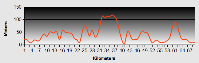
Melbourne to Adelaide - Melbourne to Lorne Ride Profile
Ride Description
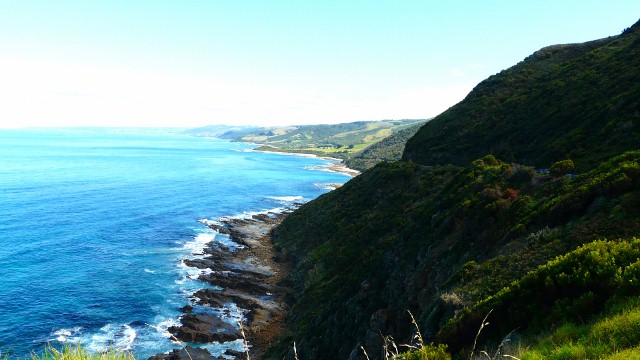
Our Melbourne to Adelaide ride started from Geelong and followed a designated cycle route to join the Surf Coast Highway which took us down to Torquay. The Melbourne to Adelaide road was straight and very busy, but had a wide shoulder.
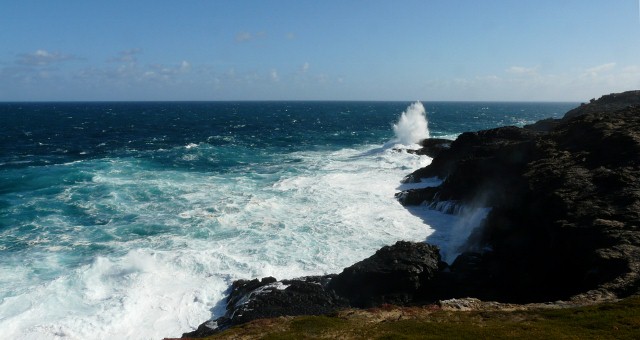
After Torquay the Melbourne to Adelaide road finally starts to follow the coast, over high bluffs and cliffs with lovely views over the beaches where there were crowds of surfers. At Anglesea we sat in the warm sunshine to eat our lunch and, for the first time for several weeks, it was warm enough to melt the chocolate on our biscuits. Shortly we came to the start of the Great Ocean Road, the building of which is commemorated by an archway.
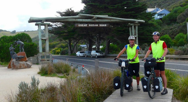
The present archway at the start of the Great Ocean Road is the fourth, the previous ones having been destroyed by fire, storm and road widening. The Great Ocean Road was constructed with pick and shovel, by soldiers returning from World War 1 and so is the World’s biggest war memorial.
Before we reached Lorne, as we climbed out of Grass Creek, Karen spotted an injured bird at the side of the road, next to the crash barrier.
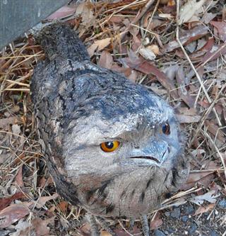
It was a Tawny Frogmouth and seemed to be stunned or possibly poisoned. Although it was quite calm it had a vicious looking beak that it wasn’t afraid to keep showing us. To stop it being run over, Karen wrapped it in her towel to pick it up and placed it carefully in the grass over the barrier.
The campsite was by the side of the river with lots of ducks with their ducklings and cockatoos. As the sun set it created a pink reflection on the clouds and we looked forward to a peaceful night’s sleep.
Now we were only 3 weeks away from our planned departure from Australia we had to sort out our visa problem. Because we had left it so late to get our visas we could only apply for the 3 month visitor online. The web site assured us we could apply for an 3 month extension to this. When we logged on we found there was a charge of $255 each to do this. As we only needed to extend by 3 days this was a bit steep. We rang the helpline to see if there was a day count for the 3 months, as entering on the 15th February meant that we were actually spending only 92 days in Australia. They were typically unhelpful so in the end it was cheaper and less risky to just bring our Singapore flights forward three days.
Melbourne to Adelaide - Day 2 - Lorne to Apollo Bay
- Distance 44.7km
- Max Elevation 62m
Melborune to Adelaide - Lorne to Apollo Bay Ride Profile
Ride Description
The peace of the previous evening was broken by a group of four girls in the adjacent tent, laughing, shouting and swearing until the early hours of the morning. There were lots of grumpy campers this morning and we were probably not the only ones to complain when we left.
The Melbourne to Adelaide road from Lorne hugged the coast all the way, rising and falling as it went over bluffs and descended into river valleys. The sun was shining and there were lots of motor bikes, classic cars and camper vans enjoying the ride. This was the Great Ocean Road that we had been expecting and it didn’t disappoint us. Traveling west on a bike means that you are closest the cliff edge so have the best possible view of the sea.
After a coffee stop at Kennet River, we climbed once again to the highest cliffs in Victoria at Mount Defiance lookout.
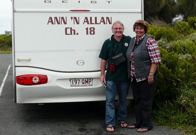
We chatted to three motor cyclists from the USA and were really interested in the tiny camera that one of them had mounted on his helmet. This was also the first time that we saw a particular caravan with "Ann and Alan Ch. 18" written on the back in large letters.
The Melbourne to Adelaide road then dropped back down to the ocean for the gently rolling, final 10km into Apollo Bay, but first we stopped for lunch, sitting on the beach and paddling in the rock pools.
Apollo Bay is a pleasant seaside town, with expensive holiday homes, bars and restaurants along its promenade. After shopping, we headed to our camp site at the recreational reserve just outside of town. It was cheaper than the town center sites and basic. The camp kitchen was an open barbecue area and wasn’t very clean, but it did have an open fire. We met John, a young Australian guy who seemed to be into building development, sports coaching and all sorts of other things. It was difficult to tell how much of his banter was real and how much was make believe.
John bought some wood and we got the fire going. Later we were joined by a group of German and Swiss travelers. John fetched his guitar and each of us took a turn at trying to string together a tune or two.
Melbourne to Adelaide - Day 3 - Apollo Bay to Lavers Hill
- Distance 47.3km
- Max Elevation 450m
Melbourne to Adelaide - Apollo Bay to Lavers Hill Ride Profile
Ride Description
Due to a clear sky, the night was very cold and we struggled to drag ourselves out of our cosy beds. The tent was covered with a heavy dew outside and condensation inside. By 9-00am the sun was up and it wasn’t long before everything dried out. We knew that we were in for some long climbs today, but nevertheless, we set off on our Melbourne to Adelaide ride in good spirits.
Immediately, the Melbourne to Adelaide road out of Apollo Bay started to climb North West, away from the coast and continued for the next ten kilometers over the Cape Otway headland. Even though we were told there were koalas in the wild on the headland, we decided against the 7km detour to the Otway Lighthouse.
The descent was steeper and shorter and eventually the Melbourne to Adelaide road curved south west along the side of the broad, marshy Aire Valley back towards the coast. Time for the second hill climb of the day, but before that we stopped with the other tourists to take in the views from the cliffs to Glenaire Beach.
Over the last two days we had been playing leap frog with "Ann and Alan" in their caravan and we met them again. This time he came and chatted with us about our Melbourne to Adelaide ride.
We girded our loins and got back into the saddle for a steady climb, varying between 1st and 3rd gears. After 20 minutes we stopped for lunch, fending off the marauding mozzies as we ate. The climb continued up and up for another 10km before we finally reached the outskirts of Lavers Hill with the choice of three cafes to tempt us. The one promoting Devonshire cream teas won out but they were out of scones.
Tea and cakes have the miraculous ability to transform tired and dejected cyclists into energy laden athletes ready for another 30km. But not today! The camp-site was just 1km further down at the Roadhouse Tavern. It had seen better days and appeared to be undergoing a half hearted renovation of sorts. Unfortunately there was not a food shop in town so we were forced to dine at the Tavern. It was surprisingly good food and the owner only charged us $10 for the camping.
Melbourne to Adelaide - Day 4 - Lavers Hill to Port Campbell
- Distance 49km
- Max Elevation 450m
Melbourne to Adelaide - Lavers Hill to Port Campbell Ride Profile
Ride Description
It was quite clear and dry when we got up in the morning, but before breakfast was finished the clouds had rolled in and the rain started. The scene was set.
We had expected an easy descent from Lavers Hill at 590m, but the Melbourne to Adelaide road continued through rolling countryside for several kilometers. There was a turnoff signposted to Moonlight Heads along an unsealed road. On the map it looked like this road continued along the coast, before rejoining the main road just before Princetown. We decided to give it a try. After about 3km, most of it downhill, we asked some tourists coming in the opposite direction and it appeared the road was a dead end. Dejectedly we climbed back up the steep rough hill back to the main road, where we met our motorcycling friends again.
Once back on the Melbourne to Adelaide road there was an exciting long and twisting descent through the gum forest. With a wave, the motorcyclists passed us on the way down. The road flattened out for the next few kilometers As we rounded a bend there were the bikers again, in a lay-by. As we passed them Steve commented "Hey, you guys have more rest stops than we do". It turned out that one of them had hit a wallaby, which lay dead at the roadside. They passed us once more, but that was the last time that we would see them.
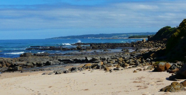
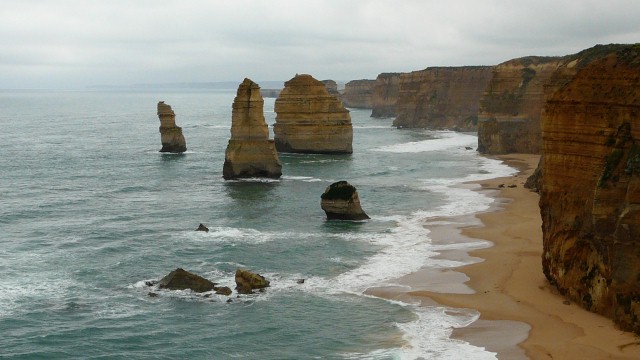
At the next settlement, Princetown, we rode up the hill into town which was just having its road resurfaced. Energised by this refreshment we continued on to Gibson’s Steps, a viewpoint over the bay containing two rocky pinnacles called Gog and Magog. There is a flight of steps down to the beach and crowds of tourists all puffing and panting their way up the narrow stairs.
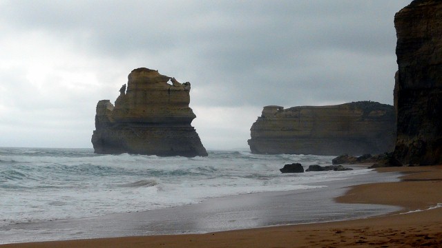
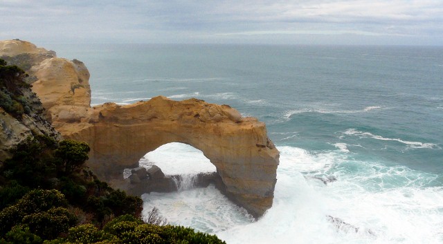
Just beyond this is one of the most iconic sights of the Great Ocean Road, the Twelve Apostles. There is a huge car park and visitor centre and coach loads of sightseers but it is a stunning natural feature. Unfortunately there are now only seven rock stacks left of the original Twelve Apostles, the others having collapsed into the sea.
The Melbourne to Adelaide road continues along the cliff tops with several turn offs to other famous sea eroded features such as Loch Ard Gorge and The Grotto. The weather was deteriorating and it started to rain quite heavily so we gave them a quick scan and pushed on to Port Campbell. We were wet and cold so booked into a small backpackers on the harbour. There was an open fireplace and a huge pile of red gum, so with a large fire and the whole place to ourselves we had a relaxing evening.
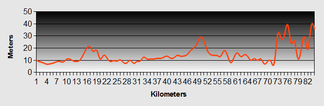
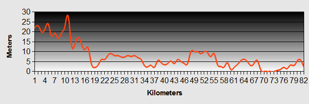
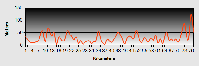
Melbourne to Adelaide - Day 5 - Port Campbell to Kilarney
- Distance 82.6km
- Max Elevation 78m
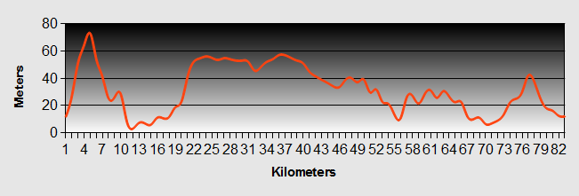
Melbourne to Adelaide - Port Campbell to Kilarney Ride Profile
Ride Description
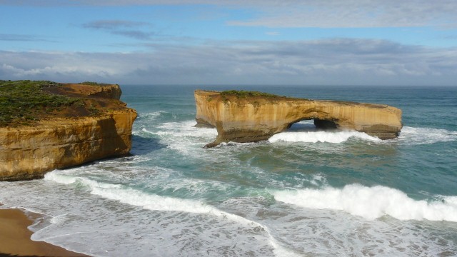
It poured with rain for most of the night but the day dawned dry and windy. The Melbourne to Adelaide road climbs back to the top of the cliffs as it leaves Port Campbell and then there are a succession of famous landmarks. Stopping and taking photographs at each one took quite a long time so by lunchtime very little progress had been made. But we had seen The Arch, London Bridge, Bay of Martyrs and Bay of Islands, all with huge waves breaking and a lot of sea mist. At the Bay of Islands lookout we met Ann and Allan for the last time as they were heading north.
From there the Melbourne to Adelaide road leaves the coast, turning inland and passing through quite boring, flat pasture. With the wind was strong and westerly, most of the time we were riding into it. The traffic was quite heavy and this section was not enjoyable. There were no lay-bys or picnic areas so to escape the cold strong wind we ended up eating our lunch in a bus shelter at the side of the road.
At Warnambool we stopped to shop for food and popped into McDonald's to check e-mail. There was a message from Ben asking if we would be able to go to their wedding on September 7th. Two sons wed in four months!
By now it was getting to be dusk, the weather was dull and drizzling and there was still about 20km to Kilarney so the high vis jackets and lights were needed. The camp-site at Kilarney was a little way from the main road, at the side of the beach. It was one of the cheapest since Melbourne.
Melbourne to Adelaide - Day 6 - Kilarney to Portland
- Distance 84km
- Max Elevation 40m
Melbourne to Adelaide - Kilarney to Portland Ride Profile
Ride Description
There was not much change in the weather today, still cold with a strong head wind and threat of rain. It was about 10km to Port Fairy, a lovely historic port town with restored old buildings where we had coffee. After that it seemed a long, long slog. The head wind slowed progress to a miserably slow speed and again it was away from the coast, through farmland and plantations.
At lunchtime we found a small volunteer fire station shed in a clearing at the side of the road and sat in a brief sunny spell, sheltered from the wind. Soon after that it started drizzling and then pouring. There was no point in sheltering and there was still a long way to go.
Arriving in the little town of Narrawong we saw a cycle path on the opposite side of the road. As we paused to try and cross the road a woman came out of her house and offered us a warm by her fire and a cup of tea. How could we refuse.
Warmed and slightly drier there was just the last 15km to Portland to complete and again the dusk was fast approaching as we navigated our way through some long country lanes to find Dave and Kerry’s house, our Couch surfing hosts.
By the time we arrived there was just about time to introduce ourselves before they had to dash off to their Easter Thursday church service. When they returned we had a lovely meal and a good sleep in a very comfy bed.
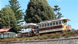
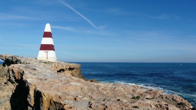
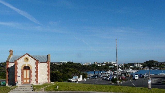
The next day we had a lie-in till 9am, pure luxury. Kerry and Dave took us on a tour of the local landmarks, including Cape Bridgewater, Portland harbour and Cape Nelson. Portland has a large wood chip factory, exported in large ships to Japan, and a huge aluminium smelting factory. There was a fishing competition being held so lots of people were fishing around Portland harbour. There is a recently renovated tramway running along the edge of the harbour.
In the afternoon Steve had a little nap while Karen worked on the blog. In the morning the weather was still unsettled so we loaded all our gear into the back of Dave’s car and he drove us to Nelson, 55km further along the coast. We went on a gravel road along the Gleneig Valley where there are lots of beautiful small camping areas in the forest, beside the broad, meandering Gleneig River.
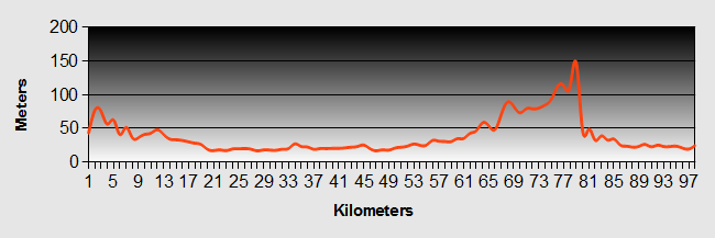
Melbourne to Adelaide - Day 7 - Portland (car to Nelson) to Mount Gambier
- Distance 109km
- Max Elevation 150m
Melbourne to Adelaide - Portland to Mount Gambier Ride Profile
Ride Description
After lunch in the tavern at Nelson, we said our goodbyes to Kerry, Dave and set off along the Melbourne to Adelaide road for a short ride to Mount Gambier, a town set on the side of an old volcano. The campsite here was right in the centre of the town but surprisingly, was very quiet. There was another cycle touring couple there. They had been on a one week circular tour of the area and were totally fed up because of the weather and the strong head winds. They weren’t particularly sympathetic when we told them that we too had the same struggle.
That evening Karen went to clean her teeth and put down her head torch on the sink. After walking back to the tent she realised she didn't have the torch and went back, but in the 3-4 minutes it had disappeared. No reading in bed for a while.
Melbourne to Adelaide - Day 8 - Mount Gambier to Millicent
- Distance 67.4km
- Max Elevation 150m
Melbourne to Adelaide Mount Gambier to Millicent Ride Profile
Ride Description
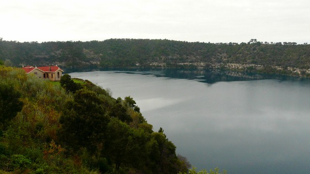
Before leaving, we climbed up to see the famous Blue Lake in the crater of the volcano. During the summer this lake is an incredible bright blue colour. During April the colour gradually fades to a more normal blue grey but then the bright blue reappears over just three days in November. All of the town's drinking water is pumped from this lake.
Mercifully today was warmer and the wind was less, meaning faster progress. Our Melbourne to Adelaide route took us off the Prince's highway to follow the Southern Ports highway. There was a sink hole at the side of the road which we stopped to look at. There was a cave entrance with deep, clear water and just as we were leaving a group of divers arrived to go into the depths.
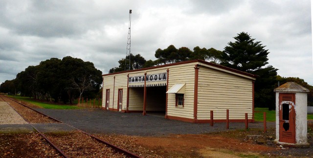
We had lunch in a park in Tantanoola at the side of the now disused railway line. The original station building was still there and seemed very sad and dejected.
Just outside the town was a huge Kimberley Clarke wood pulp mill, it took ages just to ride past it.
As we continued Karen's back wheel started to display the same symptoms as Steve's had three weeks earlier in Tasmania. There was a definite bulge and riding it felt like the wheel had gone square. This tyre too had split along the inside. Luckily it wasn't far to Millicent where Steve did his best to patch it up with a splint of plastic from a milk carton. We would have to try and get a new one along the Melbourne to Adelaide road.
Melbourne to Adelaide - Day 9 - Millicent to Robe
- Distance 81.8 km
- Max Elevation 30m
Melbourne to Adelaide - Millicent to Robe Ride Profile
Ride Description
At last, a summer's day with clear blue skies and sunshine. We’d forgotten where the suntan lotion was. Progress was fast again today along flat country which had been marshes before being drained.
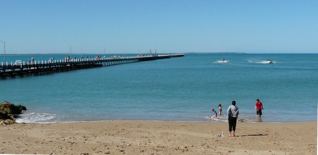
About halfway we rode down into Beachport, a popular tourist resort. As today was Anzac day we were treated to free Anzac biscuits with our coffee. Beachport is famous for once having the longest jetty in South Australia (or maybe the whole of Australia?) The original estimate for the construction of this jetty in 1876 was 26,000 pounds! When completed it was 1,220m in length, but is now a mere 770m, still pretty long.
The road from here runs at the side of three large lagoons, separated from the ocean by sand dunes. This area is very popular for 4WD vehicles, driving along the beach and through the dunes. There were large convoys of vehicles passing us, all equipped with large orange flags and ropes and spades to dig themselves out.
We rode up to the top of a small hill to see the Wainwine Cutting. An enterprising local farmer decided that he would cut a channel through the hill to the coast to drain his land on the other side. Despite advice that it would not be possible he excavated a deep channel with almost vertical sides and managed to turn the marshes into productive farmland.
Robe was another tourist magnet, crowded with Easter holiday makers. It was also very expensive to camp, $35.
Melbourne to Adelaide - Day 10 - Robe to Kingston SE
- Distance 67.4km
- Max Elevation 26m
Melbourne to Adelaide - Robe to Kingston Ride Profile
Ride Description
We were woken at 4am by the camper van on one side of us leaving early, then again at 5.30am as the ones on the other side started packing up too. At least the sun was shining to cheer things up. Before leaving we took a quick tour of the town’s attractions, the Obelisk, Doorway Rock, the marina and old customs house.
Exhausted by these tourist exertions we had to have coffee before leaving Robe but passed on the very expensive cakes. At the cafe we met Irene and Garth, a South African couple living in the Barossa Valley. They both enjoyed cycling and chatted about our Melbourne to Adelaide ride for ages.
As this was the last day of the school holidays the Melbourne to Adelaide road was busy with families returning home after the long weekend. They all had trailers loaded with every possible accessory for the perfect camping holiday, chairs, tables, canoes, inflatable things to drag behind the boat, bicycles, surf boards. One even had a settee roped onto the roof rack. That’s my kind of camping.
To avoid the heavy traffic we took a minor road detour around Cape Jaffa. The quiet road had wide verges full of autumn wild flowers that in the warm sunshine were a-flutter with hundreds of butterflies. The air was also full of flying bugs and huge grasshoppers.
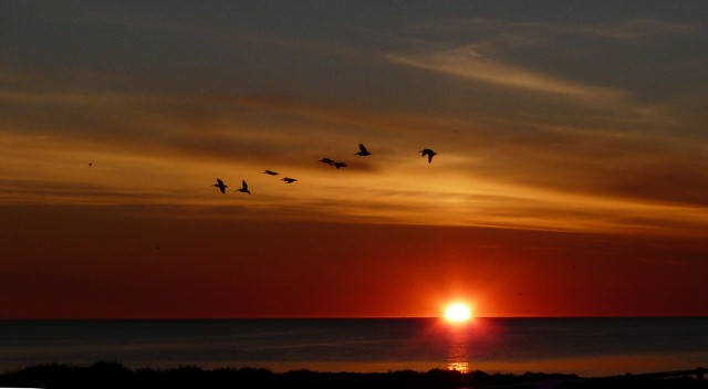
Kingston was a much less touristy place than Robe and the camp site was on the sea front. It was warm and for the first time for weeks a hot shower wasn’t needed to thaw us out. The sunset was stunning, the sun dropping below the sea horizon and turning the sky crimson and orange.
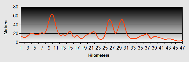
Melbourne to Adelaide - Day 11 - Kingston SE to 42 Mile Crossing
- Distance 71.1km
- Max Elevation 12m
Melbourne to Adelaide - Kingston to 42 Mile Crossing Ride Profile
Ride Description
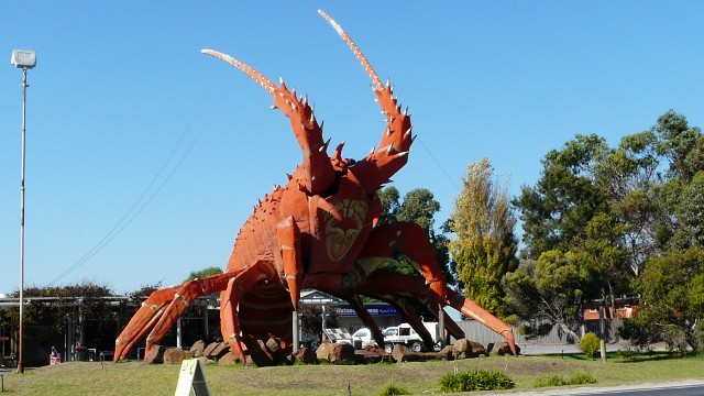
There were a few housekeeping jobs to be done today. Steve had to write a letter to NSI which involved begging a sheet of paper and envelope from the camp office and then going across to Tourist information to get on the internet. Then a new tyre had to be purchased for Karen’s bike as she was sick of bumping along the road. By the time we set off it was gone 11am and, believe it or not, the wind was still strong and head on. Kingston has a big Rock Lobster fishing industry and there was a particularly large specimen on the way out of town.
At least it was sunny and the traffic was lighter today. The road had a hard shoulder but it had a very rough surface so we cycled on the road mostly, skipping onto the shoulder to let traffic pass. We saw three other tourers today, all travelling towards Melbourne. The first were a young couple who were travelling fast and just shouted a greeting. The second was another ’young man’, Andy who had cycled from Liverpool over the last 15 months through Turkey, Iraq, Kazakhstan, Kyrgyzstan, Russia, Mongolia, China and across Australia from Darwin to Adelaide. He looked a little weather beaten but still very happy.
As the Melbourne to Adelaide road was straight and fast there was more road kill, lots of large kangaroos and lizards. The road follows the coast for 145km along the Coorong National Park. Most of the way there were trees and shrubs which gave shelter from the wind, but in some places there were huge flat grass pastures where the wind slowed us to 12kph.
The camp site at 42 Mile Crossing was a National Park one, there were toilets but no drinking water or showers. That night there was a clear sky and the most fantastic view of the millions of stars.
Melbourne to Adelaide - Day 12 - 42 Mile Crossing to Meningie
- Distance 76.7km
- Max Elevation 120m
Melbourne to Adelaide - 42 Mile Crossing to Meningie Ride Profile
Ride Description
Today was basically a repeat of yesterday, same weather, same scenery, same Melbourne to Adelaide road. The only difference was there was a more rolling road which gave better views over the salt flats to the high sand dunes. Except for a welcome coffee stop at Salt Creek the day was a relentless battle against the wind with very little to inspire interest. It was an i-pod and keep pedalling day.
Stopping for a coffee at Salt Creek we saw a swallow’s nest with a bird sitting on eggs. It is very confusing here. March is the middle of autumn but this week we have seen new born lambs and swans with young cygnets.
Melbourne to Adelaide - Day 13 - Meningie to Wellington
- Distance 45.1km
- Max Elevation 205m
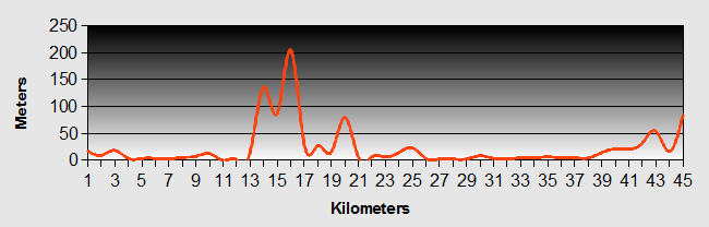
Melbourne to Adelaide - Meningie to Wellington Ride Profile
Ride Description
Meningie is on the shores of Lake Albert, a fresh water lake famous for its pelicans. The road continues along the shore of the lake then heads more inland. For the first 20km there were some low hills but then the next 20km was just one long, straight flat. We don’t think we could cope with cycling across the Nullarbor.
The road to Wellington turns off about 8km form Tailem bend. To get to the town there is a chain ferry across the Murray River. The ferry is one of twelve still operating across the Murray, all free and funded by the Australian government.
We camped at the small camp site near the river, just across the road from the hotel which served very good food and was very busy with local diners. After dinner we went to the bar to watch the wedding of William and Kate on the television.
Melbourne to Adelaide - Day 14 - Wellington to Strathalbyn
- Distance 48km
- Max Elevation 70m
Melbourne to Adelaide - Wellington to Strathalbyn Ride Profile
Ride Description
The final whisky the night before caught up with Steve in the morning and he was decidedly jaded, complaining also of a stomach ache, for the second day. It was dry but overcast with threatening rain in the air. Just as we finished breakfast the first drops fell and we rushed to pack everything up, but then it stopped again.
The Melbourne to Adelaide ride continued along flat plains skirting around the top of Lake Alexandrina. The wind was light and we were rolling along doing 20km+. We soon arrived at the start of the Langhorne Creek wine region and rode through acres of vineyards. At the village of Langhorne Creek we deliberated whether to do a vineyard tour, but Steve’s was suffering with his stomach ache and stopping for alcohol so early in the day would probably not have helped. Instead we opted for a coffee at the village shop. By now it had started to rain persistently.
The terrain was certainly more interesting now, being more rolling and diverse. It was only another 16km to Strathalbyn, our final destination for a quite easy short day’s cycling.
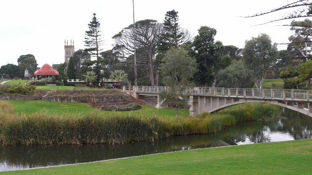
Strathalbyn was settled by the Scots in the early 1840s and made its fortunes from wool and farming. From the start the town was well planned straddling the Angas River (yes, that is Angas not Angus). One of the first buildings was a small log cabin hotel which was later replaced and still stands today as the Terminus hotel. The Uniting church overlooks a lovely park dedicated to the Anzac forces, on the banks of the river and the town has lots of bric-a-brac and collectables shops.
Due to the rain we checked into the cheapest hotel we could find, The Robin Hood, but still had to pay $90 per night. It was basic but dry.
We also noticed another cyclist arriving, but didn’t have chance to talk with him.
Steve’s stomach was still causing concern and Karen seemed to be having similar symptoms. Our thought turned to one of three things. The rainwater that we had been drinking at the 42 mile crossing, the mosquito bites that we had received at the same site or the seafood that we had eaten the night before. We ate light and went to bed early.
The next day we awoke to rain, but packed our things anyway ready for our departure.
Over breakfast we got talking with Ernst from Switzerland who had cycled from Perth across to Ayers Rock and then south to Adelaide. He had done a lot of cycle touring and had also spent two years in a Buddhist monastery in Thailand. He was very interesting to talk and a mine of good information.
The three of us talked each other into not cycling anywhere today and staying put in the dry of the hotel. We spent the day working on the blog and touring the town.
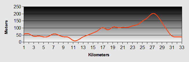
Melbourne to Adelaide - Day 15 - Strathalbyn to McLaren Vale
- Distance 47.5km
- Max Elevation 400m
Melbourne to Adelaide - Strathalbyn to McLaren Vale Ride Profile
Ride Description
At last, sunshine and no rain. Ernst was ready to leave by 8.30. We were slower as we were both still unwell. For the first time in 10 days there was a decent hill to climb, views over green fields, mature gum trees and small river valleys. After a long climb out of Strathalbyn there was a super slow descent for about 10km down a pretty river valley.
Going past a field of milking cows we spotted one lying on its side on the ground with its legs stuck out rigidly and rolling its eyes. Stopping at the farmhouse nearest to the field we found the farmer who was chatting to a pair of delivery men. We reported the cow problem and he glanced over at her, "looks like she’s dead". He went off to see while we chatted to the delivery men. When he returned he had a smile on his face. The cow had fallen over and couldn’t get back on her feet. With a bit of assistance she was now up and happily grazing as if nothing had happened.
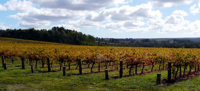
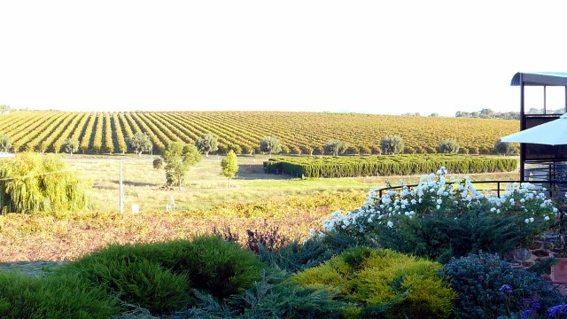
We were now into the McLaren Vale wine area and passed numerous vineyards. The vines looked quite pretty with their autumn golden leaves.
In amongst the vineyards was a field with camels, ponies and donkeys.

Even though we were still feeling rough, we couldn’t pass through this famous wine area without having a tasting. So after pitching the tent we rode about 500m up the road to Maxwell's (this was the nearest) of their reds and a mead and brought a couple of bottles to share with our hosts in Adelaide tomorrow. It is called "Silver Hammer" after the Beatles famous track and had been the subject of a failed copyright action.
Melbourne to Adelaide - Day 16 - McLaren Vale to Adelaide
- Distance 32.2km
- MaxElevation 200m
Melbourne to Adelaide - McLaren Vale to Adelaide Ride Profile
Ride Description
The night was very chilly but when we woke we both felt a lot better and keen to finish our ride from Melbourne to Adelaide. From the town we took the rail trail called "Vines to Coast" which winds its way through the hills. There had been no internet connection for a few days so when we spotted a McDonalds we stopped for coffee and checked the location of our Warmshowers accommodation on Google maps. It was actually not far from where we were.
As it was still early there was an excuse for a long lunch break, sitting in the sunshine in one of the parks on the cycle route. After lunch we left the rail trail, turning onto the "velo route" which runs at the side of the Southern Express-way. It climbed up to the top of a hill with fleeting views over the CBD then a fast downhill into Marion. From here we had to navigate our way to Mitchell Park and did get a bit confused at one point, especially as Steve thought we were going to Marion Park.
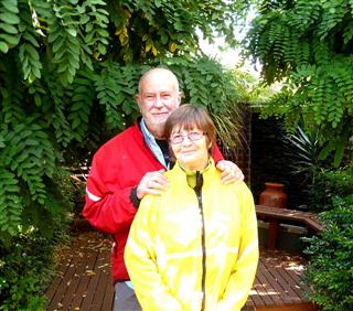
Once we were going in the right direction again we easily found David and Noelene’s house which is about 10km from adelaide CBD. David is a keen photographer with some fantastic collections of photographs of Australia. He also has one of the largest collections of cycle touring books we have ever seen.
They made us very welcome and Noelene cooked us the most delicious roast pork dinner.
New! Comments
Have your say about what you just read! Leave me a comment in the box below.