A Circular Bicycle Tour of Tasmania with its wonderful scenery, divers environment and friendly people.
Tasmania was a reall surprise to us. Having been in New Zealand and been a little disappointed with the ride south from Sydney we didn't really know what quite to expect in Tasmania. We felt that it was much more like New Zealand than Australia. It had some of the diversity of New Zealand, with that smaller island feel. The scenery and diversity were both stunning and beautiful. The islanders that we met were warm and friendly and the island had a lot more culture than we expected. This giro route really does make a great cycling tour.
Schedule
- Devonport to Gowrie Park
- Gowrie Park to Cradle Mountain
- Cradle Mountain to Rosebery
- Rosebery to Zeehan
- Zeehan to Strahan
- Strahan to Lake Burberry
- Lake Burberry to Derwent Bridge
- Derwent Bridge to Wayatinah
- Wayatinah to New Norfolk
- New Norfolk to Hobart
- Hobart to Richmond
- Richmond to Triabunna
- Triabunna to Swansea
- Swansea to Coles Bay
- Coles Bay to Bicheno
- Bicheno to St. Helens
- St. Helens to Launceston (by bus)
- Launceston to Exton
- Exton to Devenport
Our ride descriptions give an account of the ride that we completed. As part of the description we also provide links to Wikiloc or Google maps and elevation profiles based on mapping data available through the internet. The ride profiles are smoothed to give what in our opinion is a more beneficial view of the profile. We use paper maps, GPS and on line data to plan and conduct our rides. We are happy for you to use our descriptions, but be aware that we do not guarantee the accuracy of the information provided as situations surrounding any ride change over time.
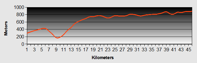
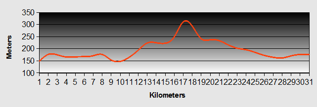
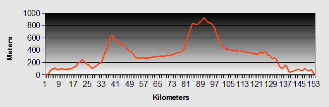
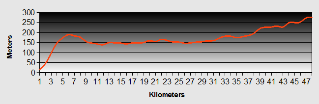
Tasmania - Day 1 - Devonport to Gowrie Park
- Distance 48.1km
- Max Elevation 300m
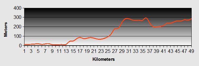
Tasmania - Devonport to Gowrie Park Ride Profile
Ride Description
We had decided to use the "Giro " route that we had downloaded from the internet. It is an eighteen day circuit of the Tasmania on mostly tarmac roads, with suggestions for several side trips. It gives details of budget accommodation, camp sites shops and other useful information. There is also a tour in the Lonely Planet guide to cycling in Australia.
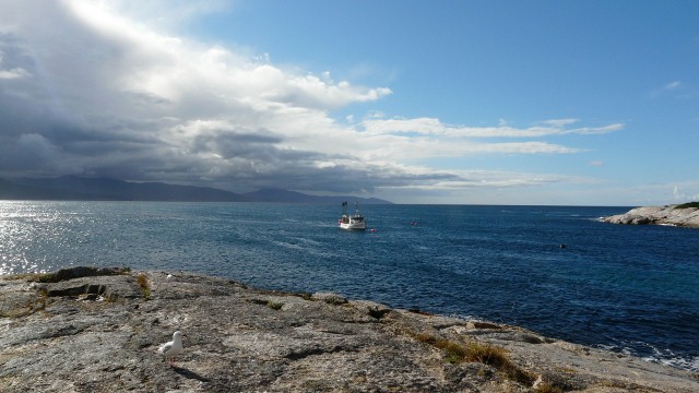
The ferry public address system woke us at 5.45am to get ready for the boat docking at 6.30am. It was still dark so it was reflective jackets and lights to get out of the ferry terminal and down the road to a motel offering cheap breakfast. As we ate, the only other cyclist who had been on the ferry came in and joined us. His name was Claude and he lived in Bagdad, near Hobart. He was returning from a solo trip round the wineries of Victoria. Surprisingly he still seemed to be able to walk in a straight line.
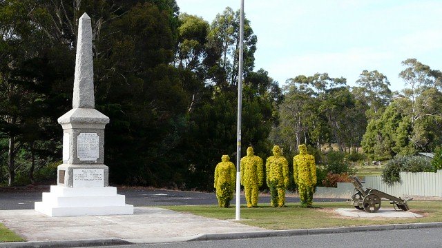
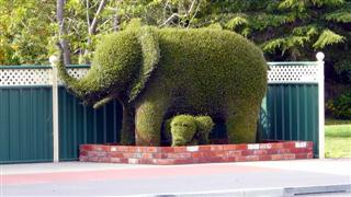
By the time breakfast was finished it was light but the weather was overcast and dull. The motel receptionist advised us to cycle up River Road to Latrobe and it was a scenic, quiet road along the banks of the Mersey River. From there we headed along the B13 to Railton "town of topiary". They had several impressive modern topiary sculptures, grown by training the growing climber through chicken wire formers.
There was an elephant, a crocodile and a Tasmania tiger as well as topiary soldiers at the war memorial.
From there the road started to climb up through forest and pine plantations to Sheffield "town of murals".
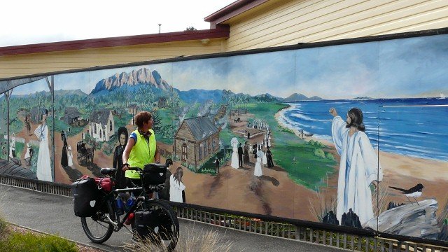
Initially the murals were used to brighten the boring brick sides of the building and shops along the road but now there are so many they have a display around the public park and hold an annual mural festival where more are painted.
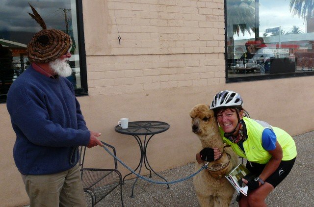
Outside one of the cafes was Ludo with his pet alpaca waiting for tourists to take photos and put cash in the box. Seems like a good way of making money.
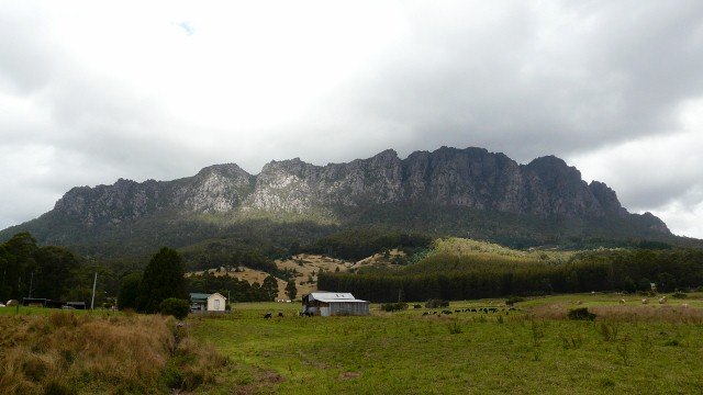
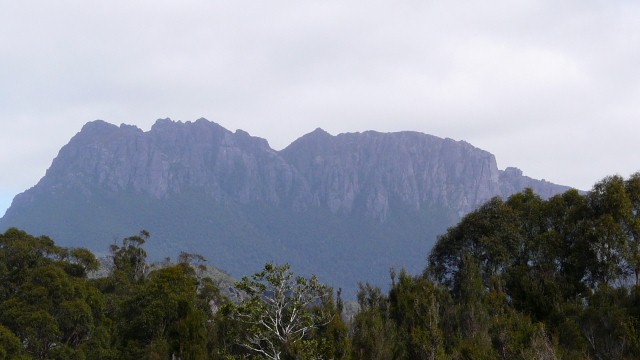
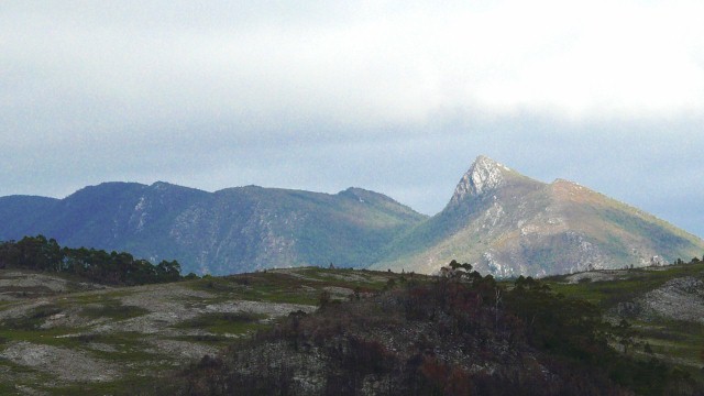
Our Tasmania route from here would have no supermarkets for at least three days so we stocked up before leaving. As we climbed the hill out of Sheffield there were great views of Mount Roland ahead, with its exposed rocky top catching the afternoon sun, but by the time we crested the hill and found a place to take a photo, it had disappeared behind an approaching rainstorm.
Gowrie Park used to be an important town where the construction workers for the hydro electric power scheme lived, but now there is little here except the camp-site. The tent had only been pitched for about 30 minutes when it started raining. For four hours it poured and it could not soak into the ground fast enough so the groundsheet had water coming up through it as if it had lost its waterproofing.
In a lull between downpours Steve went and booked a cabin and then had to move all the gear and take down the tent to dry it out in the large recreation room, which happened to have a large log fire.
The rest of the cabins were all occupied by a group of men on an industrial diving course which uses the deep waters of the nearby reservoir. They had an evening meal arrangement at the camp-site restaurant so we asked if we could have the same menu, two delicious home-made courses for $25 each.
The next day we begged a lift back to Devonport to buy a new groundsheet and also a couple of new waterproof jackets as it looks like there will be a lot of rain over the next month. In the evening we chatted to a Canadian couple in a camper van, touring Tasmania and who had just returned from Cradle mountain because the weather up there had been so bad. They were having a one year sabbatical from their jobs to travel the World.
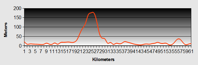
Tasmania - Day 2 - Gowrie Park to Cradle Mountain
- Distance 45.2km
- Max Elevation 820m
Tasmania - Gowrie Park to Cradle Mountain Ride Profile
Ride Description
Overnight there were strong winds and more rain but at least we were snug and dry in our cabin. After a lie-in and a leisurely breakfast it was still drizzling so we set off at 11am. Everyone had warned us about the hill that had to be climbed today out of the Cethna valley. The camp-site owner advised us to get the bus up to Cradle Mountain.
Except for a 2km steep descent to the Cethna dam, the whole of today’s ride was uphill.
The 5km climb out of the valley was the toughest part but the rain kept us cool and the road was quiet. As we crested this first hill at Moina, there was a cafe where we sheltered from the rain with a hot coffee. The Canadian couple came in, amazed that we had got up the hill so quickly.
After a brief rest we continued up the hill in the pouring rain. There was lush rainforest at first and as we got higher the forest became sparser, with ancient myrtle trees covered in mosses and lichens. Higher still, there were pine and gum trees. At one point there was a dip in the road where we reached 55kph as we passed a police radar speed check. A notice at the side of the road said in huge capitals: F*** OFF PRIVATE PROPERTY. Nice people. Really welcoming.
We pushed on hoping for a break in the rain but by 2.30pm we were so hungry that we stopped to eat our sandwiches in the rain, sheltering under a fairly ineffective tree from the wind and the drizzle. As we were already damp we then got very cold and had to get going again to warm up.
The camp-site at Cradle Mountain had camp-sites for $29 or an "alpine hut" (2 benches with thin mattresses in a shed) for $40 so we opted for the latter. Included in the price was a battery lantern. As we were unpacking our gear Steve looked down and was horrified to see a leech having a feast on his ankle. Karen quickly applied some salt and the beast was dispatched. There was a fabulous camp kitchen with a huge blazing log fire. We cooked up a chicken curry and sat all evening in front of the fire.
During the night it rained heavily again and we were kept awake by the noise of the water falling on the tin roof. The rain continued for most of the day so we donned our waterproofs and walked to the Cradle Mountain Chateau where there was an exhibition photographs of Australia and Antarctica. There were some stunning pictures, especially the Tasmania ones. Part of the exhibition was the sad story of the Tasmania Tiger. This marsupial looked like a dog, was a carnivore but had a tail like a kangaroo. Because it attacked the farm animals imported by the early settlers it was feared and hated and hunted to extinction by 1930’s.
There was a free shuttle bus from the camp-site up to Dove Lake.
From there we did a short walk to Lilla and Wombat lakes.
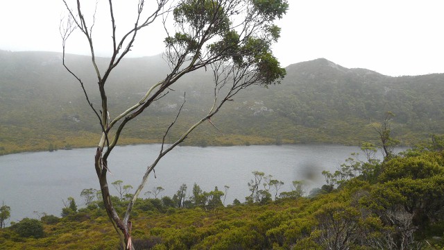
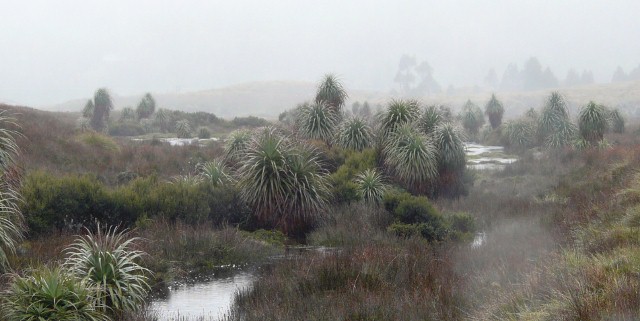
It was raining so hard it was difficult to take photos so they are all have rain spots. The annual rainfall on Cradle Mountain is 2,500mm and it rains on average 270 days per year. The mountain was invisible, shrouded with cloud and we got very wet and cold but it was still beautiful, walking across the button grass plains.
Waiting for the shuttle bus back Steve checked his shoes and found a crowd of hungry leeches crawling up the fabric, heading for his bare flesh, one already attached. Back at the camp-site we now had piles of wet clothes so we strung them in front of the fire to dry.
Tasmania - Day 3 - Cradle Mountain to Rosebery
- Distance 75km
- Max Elevation 820m
Tasmania - Cradle Mountain to Rosebery Ride Profile
Ride Description
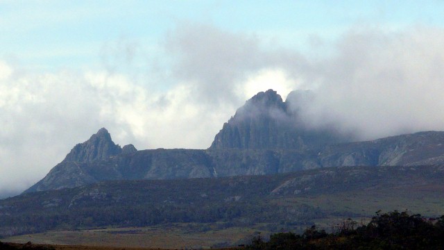
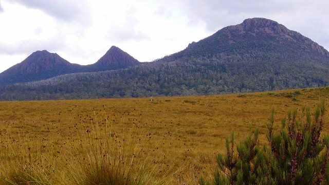
Today the weather improved, drizzling but with a few patches of blue sky promising to increase. As we descended the first hill it was so cold that Karen had to wrap her buff round her face to stop the pain in her sinuses. We rode across the high Tasmania mountain plateau through button grass and pine trees with hardly any traffic. There was a steep climb up to the saddle of Mount King from where there was a view back to Cradle Mountain. We waited patiently until eventually the clouds lifted and there was a glimpse, for the first time, of its twin peaks and Mount Pelion.
From there was another long descent and then rolling hills until the Murchison Highway. It climbed further, to its highest point at 690m, before a welcome downhill to Tullah. Having completed 54km of our Tasmania ride today we were ready for light refreshment at the local tavern. A group of middle age (i.e. our age) motorcyclists from Melbourne had just arrived too so we had to wait a while for our Devonshire cream tea. We needed the calories to take us up the 4km climb to the saddle of Mount Black, before a thrilling descent to Rosebery.
This town developed because the area has rich ore deposits from which gold, zinc, tin and iron are extracted. It is one of the few mines still working here in the west.
It is a lively, friendly place where everyone seems to want to stop and chat. In the evening we decided to try the local restaurant. From outside it did not look very promising, no customers, bare tables and chairs and a very ordinary take-away menu. When we said we wanted to eat there they produced an amazing menu with oysters and chateaubriand, but we decided on the "Mexican night" menu which was delicious. Steve, in jest, asked for a sticky toffee pudding for afters and in a trice was served with a home-made one.
On the table next to ours was a group of locals enjoying their meal. We got talking to them and the senior man on the table was the deputy mayor. He recommended going to the mining museum at Zeehan.
Tasmania - Day 4 - Rosebery to Zeehan
- Distance 30.4km
- Max Elevation 320m
Tasmania - Rosebery to Zeehan Ride Profile
Ride Description
It seemed impossible to get out of Rosebery this morning. A couple of people on the camp-site came over to chat and a Taiwanese man wanted to take a photo of us, offering us accommodation if we ever visit Taiwan. As we went to do the shopping a local lady told us her life story and then an elderly gent in the shop told us all about how he raced bicycles around Tasmania on the gravel roads.
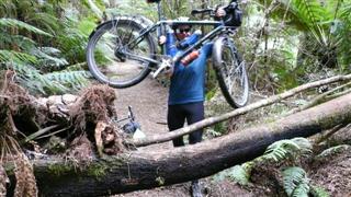
The Giro Tasmania route suggested a side trip to the Montezuma Falls, about 6km along a tarmac road to Williamsford and then 5km along an old railway track to the waterfall. What it failed to mention was that the 6km on tarmac was all uphill, followed by a steep rough descent on an unsurfaced road just to get to the car park at the start of the old tramway. At this point we decided that we couldn’t carry our gear any further so we hid it in the undergrowth.
The old tramway track was rough and wet following the recent heavy rain but it was lovely riding through the rainforest with its myrtles and tree ferns.
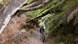
Every so often there was a fallen tree blocking the track so we had to lift the bikes over.
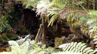
At one point there were the remains of one of the old wooden trestle bridges, now completely overgrown with ferns and shrubs. The last 2km of track still had the old wooden sleepers across which were interesting to ride over.
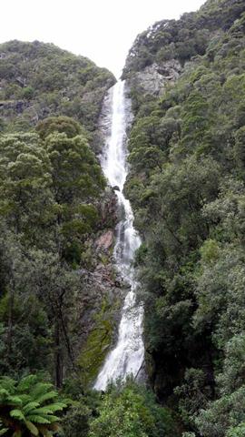
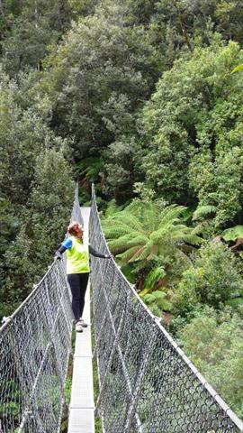
The waterfall was worth the effort. There was a newly built swing bridge across the river at the foot of the falls which was a good place for photos.
All we had to do now was ride all the way back to the main road. The last section down the hill was the best. Just before the main road we stopped in a lay-by for our lunch as it was already 2pm. A footpath from the lay-by went down to the old "works" a few derelict remnants of the old ore works and the rope way which transported the ore from the mine to the works in buckets.
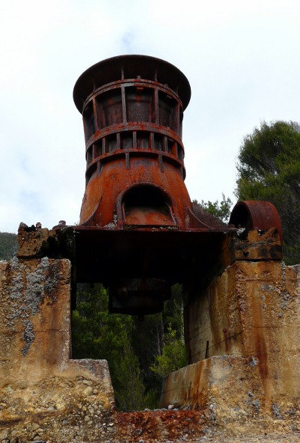
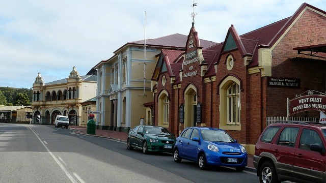
There was now a 30km ride to Zeehan which was hard work, continuously up and down low hills, through rain forest and over river valleys. Zeehan was also the site of a metal ore mine and had some restored historic buildings including the old Mining and Mineralogy School, the Court house and the Gaiety theatre, now converted to the Pioneer museum.
Tasmania - Day 5 - Zeehan to Strahan
- Distance 44.6km
- Max Elevation 225m
Tasmania Zeehan to Strahan Ride Profile
Ride Description
We spent the morning at the museum which had the most amazing collection of minerals as well as photos and artefacts connected with the Tasmania mining, timber and agricultural industries. After three hours we tore ourselves away to continue to Strahan.
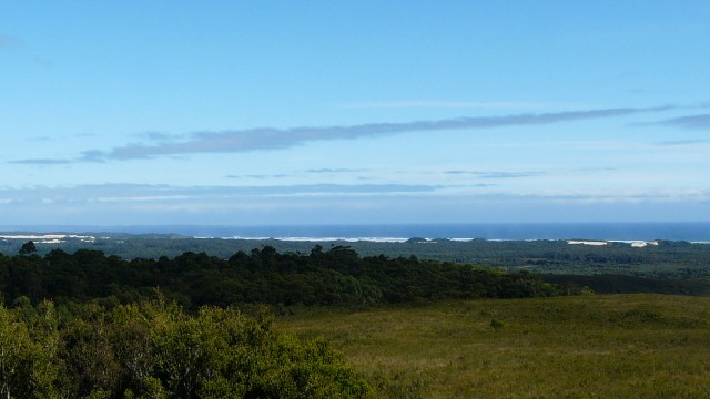
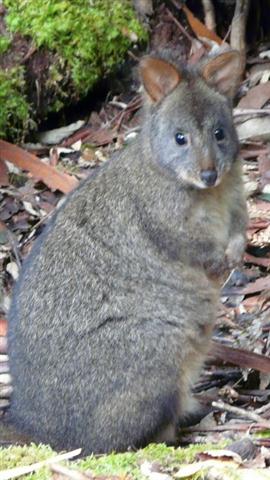
The Tasmania ride was an easier ride today with gentler ups and downs. The sun shone but the wind was still a cold southerly. For the first time we noticed the trees beginning to show their autumn colours and the rose hips and hawthorn berries in the hedgerows, a reminder that we were now into our third season in the southern hemisphere. The road kill here was mainly pademelons, a small type of wallaby, and possums.
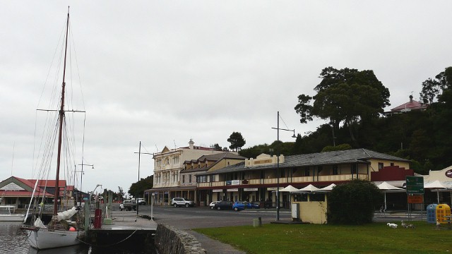
From the brow of the final hill there were views down to the southern ocean with waves breaking onto the sandy coast. The road dropped down through conifer plantations to Strahan. This was once an important port for wood and ore export but it is now a Tasmania tourist hotspot, selling cruises up the Gordon River and trips on the steam railway to Queenstown. It was tempting to do the Gordon River cruise but several people that we talked to who had done it thought that it was over-priced.
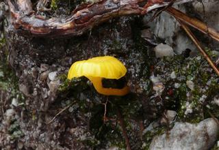
That evening we sat in the camp site kitchen chatting to another couple who had been up to Cradle Mountain. They were showing us their photographs and had taken an identical photo of a tiny yellow toadstool growing on a rock on the path up to Wombat Lake!
Tasmania - Day 6 - Strahan to Lake Burberry
- Distance 62.9km
- Max Elevation 400m

Tasmania - Strahan to Burberry Ride Profile
Ride Description
Over night there were several short showers and the morning was cold and cloudy. This is the longest spell of cold weather we have experienced, having to wear our all our warm gear every day. We cycled along the promenade to the harbour to take some photos before setting off.
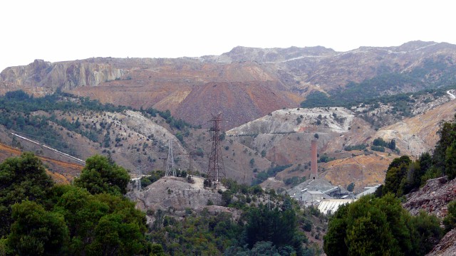
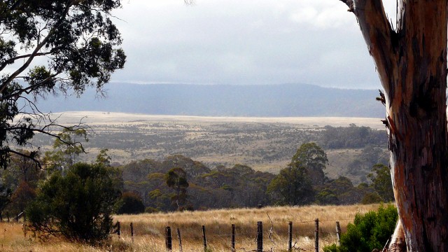
It was a long slow climb out of town and continued for the next 25km. At first there was rain forest and then button grass plains. At the highest point the views were obscured by low cloud. From there was a welcome descent towards Queenstown. As we sped downhill the road passed into the area affected by the copper ore treatment which has poisoned the soil, water and plants creating a bare landscape with no trees and bare soil. It reminded us of Andalusia.
Queenstown provided a welcome warm cafe for coffee and beefburgers. We shopped for food to last us three days as it was 175km to the next shop. The weather forecast was for more rain so we booked into the Wilderness Backpackers at Derwent Bridge for the following night.
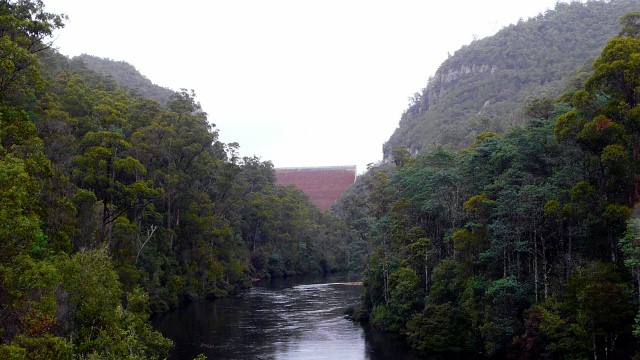
Out of Queenstown the road climbs up Gormley hill through the stark, treeless Tasmania landscape. Once over the hill it drops into a more fertile, wooded valley and is fairly flat all the way to Lake Burberry, a hydroelectric reservoir. The camp site here was cheap at $5 but there were no showers and the barbecues had been vandalised.
Steve had noticed a problem with his back wheel on the way up the hill out of Queenstown and found that the tyre was bulging because of a split and had to be replaced with the spare one. It was disappointing after only approximately 3,500km since fitting the new one at Golden Bay.
Tasmania - Day 7 - Lake Burberry to Derwent Bridge
- Distance 65.7km
- Max Elevation 820m
Tasmania - Lake Burberry to Derwent Bridge Ride Profile
Ride Description
The Tasmania Gyro route notes advised an early start today as we had a 900m climb. For the first time in over a week there was a pink sunrise and some blue sky. The tent was dry so we managed to leave by 9.30am.
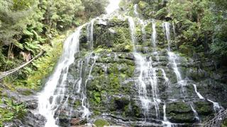
After a few kilometres we stopped to take a short walk to Nelson Falls.
From there the road climbed gently to Victoria Saddle at 530m and then descended slowly into the Collingwood river valley. This was a broad flat valley with button grass and tall gum trees. The sun came out and there was no wind, no traffic, no houses, no fences, no electric pylons, no people, just us and a smooth road. It felt like we had arrived in the Lost World of Tasmania. Stripping down to T-shirts and shorts for the first time in a week we rode slowly, trying to make the joy of the journey last as long as possible.
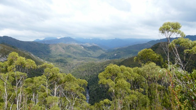
After crossing the Collingwood river there was a short climb to a saddle before dropping into the Franklin Valley. Here there was another short walk up the hill, through massive stringy bark gum trees, to a lookout at Donaghy Hill with fabulous views over the dense rainforest to the mountains beyond.
The second climb of the day was described as steep and long so we were dreading it. In fact it was much easier than we anticipated. There was hardly any traffic and the gradient was fairly gentle. It climbed up to King William Saddle which marks the east/west divide of Tasmania. During the day the wind had moved around to north-westerly and blew us up the last hill and into Derwent Bridge.
The backpackers was attached to the hotel and we had to go into the bar to check-in. This necessitated having a beer. We chatted to Richard, who had just completed a three day walk from Cradle Mountain. We later joined him and another couple of walkers, Helen and Andrew for a meal in the restaurant.
Tasmania - Day 8 - Derwent Bridge to Wayatinah
- Distance 53.6km
- Max Elevation 800m
Tasmania - Derwent Bridge to Wayatinah Ride Profile
Ride Description
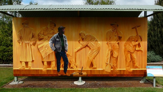
Unfortunately the good weather did not continue and the morning was cold and wet. After a cooked breakfast at the roadhouse we set off in all our wet weather gear. It was only 2km to The Wall, an incredible carved Huon pine mural, depicting the history of the area. The sculptor, Greg Norman, is a self taught artist and the carving is a "work in progress" gradually being extended and depicting the mining, farming and hydro electric history of this area.
The road passed through some beautiful forest but with a cold head wind and the driving rain it was more difficult to enjoy it today. After 20 km we took a right turn onto the C601 which was unsurfaced but was less hilly and 11km shorter than the main road. The Tasmania Giro route notes warned that it could be rough and cut up by logging trucks. In fact it was smooth and well graded. The problem was that the rain had made the top surface into sticky mud and it felt like riding through glue, especially on the slow uphill sections.
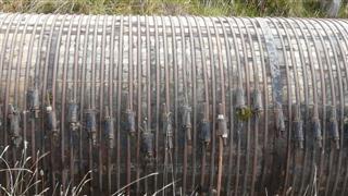
After a few kilometers the road crossed over a water pipeline that formed part of the hydro electric system. The remarkable thing was that the pipeline featured in The Wall and was made from wood like a barrel.
It was one of those days when we had to constantly change our clothes. Every time there was an uphill section the sun came out and we got so hot we had to strip off. Then on the downhills it would start to rain meaning another stop to put the waterproofs back on.
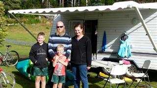
To end the day there was a steep 3km descent to Wayatinah and our already damp clothing and the bitter cold wind almost froze us. As we rode onto the camp site a couple in a caravan with their two young sons greeted us. Within a few minutes they had made us a hot cup of tea and invited us to share their evening meal.
It was still pouring with rain so we pitched the tent underneath a plastic awning at the side of an unoccupied caravan. Our tea was fresh and smoked fish, all caught by Craig and his two sons Harrison and James and cooked by Sarah. The family were spending a year travelling around Australia in their caravan. Their facebook page The Travelling Smiths documents their travels.
Tasmania - Day 9 - Wayatinah to New Norfolk
- Distance 79.2 km
- Max Elevation 410m
Tasmania - Wayatinah to New Norfolk Ride Profile
Ride Description
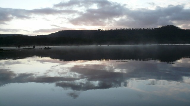
It was a beautiful Tasmania sunrise over the Wayatinah lagoon this morning. Still very cold but the rain clouds had cleared. We bid farewell to Sarah and Craig and set off again along the A10. The first 20km was very hilly, through gum forests and fast flowing hydro electric canals. Ouse was the first town for three days and the first internet connection for six. We hoped to be able to book a warm showers stay in Hobart but couldn’t find anybody near the town centre. Whilst doing the food shopping we mentioned to the lady at the till that we were heading to Mount Field National Park. She told us it always rains there and it would be freezing.
Setting off again we followed the road down the Derwent valley to the turn off for Mount Field. As we looked across towards the mountains there were grey clouds gathering and it was already raining. The road headed south west, straight into the strong wind and was described in the Tasmania Giroroute as "very hilly". It seemed a very bad idea to go that way. Instead we carried on down the Derwent Valley towards Hamilton.
It was a good decision. The wind was often behind us and except for two short hills the next 43km was flat or downhill. At one point Steve achieved 66kph. As we descended the temperature increased and we rode through wide open pastures with dry brown grass and a few pine trees.
The camp site at New Norfolk was at the side of the River Derwent and very busy, with a lot of tents. After a long ride we felt the need to eat out out and found a good restaurant called Quince where we blew a couple of days budget on a nice meal and a bottle of wine.
Tasmania - Day 10 - New Norfolk to Hobart
- Distance 26.8km
- Max Elevation 70m
Tasmania - New Norfolk to Hobart Ride Profile
Ride Description
Today was warm and a windy, north westerly to blow us into Tasmania's capital, Hobart. We continued on the A10 along the south bank of the river. From the Bridgewater bridge there is a cycle track which runs at the side of the railway, all the way into Hobart. As we hadn’t managed to get a warm showers stay we had booked into the City Central Backpackers. It was on the second floor of the building so all the gear had to be carried up two flights of stairs. The bikes got locked in the stairwell on the ground floor. It was a friendly and lively hostel with a good mix of nationalities and ages. Fed up with trying to exist without a computer, Steve decided to buy a new one and spent the rest of the evening getting it organised.
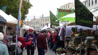
The next day we strolled around the colourful Salamanca market full of crafts, clothes and food stalls.
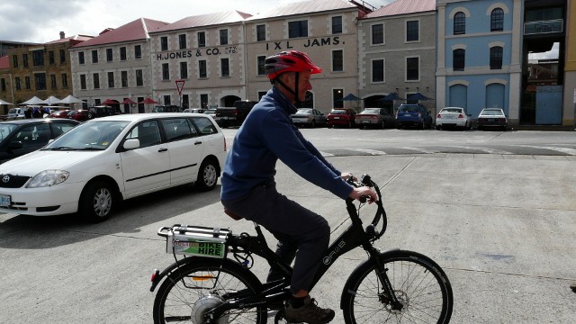
There was a place on the harbour hiring out electric bikes and Steve couldn’t resist the offer of a quick spin round the block.
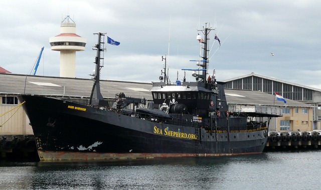
In the harbour was the "Sea Shepherd" which had just returned to dock after successfully obstructing the Japanese whale slaughter.
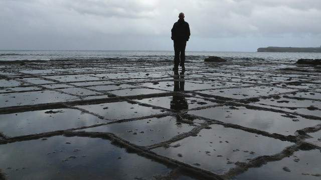
As there were so many things we wanted to see and do around Hobart we decided to rent a car for the next three days. The first day we drove to the Tasmania Peninsular, to the East of Hobart. The rocky coastline here has many sights including the Tessellated Pavement, the Tasmania Arch, the Devil’s Kitchen and the Remarkable Cave.
Being in the car it didn’t matter so much that there were strong winds and rain again. We drove to Port Arthur, famous for being the first penal colony in Tasmania but the entry fee of $30 each was too much and we didn’t go in. The Tasmania Devil Conservation park charged the same so much as we would have liked to see these unique creatures we drove on.
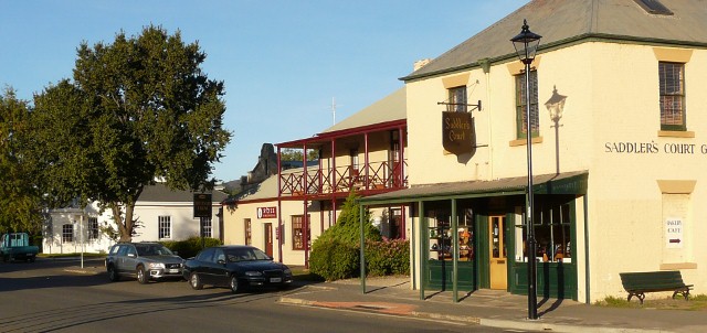
That night we decided to camp at Richmond, north of Hobart. There was a group of young East Asians camping there who were working at one of the local vineyards, harvesting the grapes. They were from Taiwan, south Korea and Japan and all spoke very good English and we enjoyed chatting with them in the evening as we ate our meal.
The next day we travelled south of Hobart to the Huon Valley and familiar sounding places such as Dover, Strathblane and Southport. A 30km drive along a gravel road through the rainforest took us to Recherche Bay which in the late 1700’s was the site of a massive Tasmania whale fishing industry. Huge numbers of whales were killed and processed here, mainly for their oil.

On the way back we drove up to the top of Mount Wellington, hoping to see the sunset over Hobart. We had to drive fast up the winding road as the sun was sinking rapidly. About 100m from the summit we ran into cloud so the view at the top was limited to the south. It was so cold we only stayed long enough to take a photo.
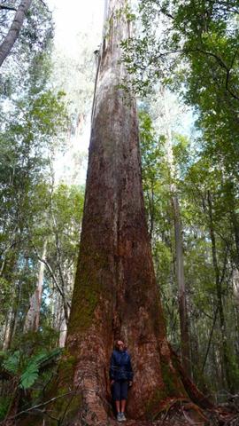
The last day there was sunshine and we drove over to Mount Field National park, along the road that we would have cycled on the Tasmania Giro route. This was the first national park in Tasmania and being so close to Hobart it is very popular. It contains the tallest flowering plants in the world. These are the gum trees, a hardwood, that grow up to 75m. Although the American Redwoods are taller they are softwood and have cones, not flowers.
We walked for a couple of hours in the forest seeing lots of colourful fungi and some pademelons.
Tasmania - Day 11 - Hobart to Richmond
- Distance 20.9km
- Max Elevation 240m
Tasmania - Hobart to Richmond Ride Profile
Ride Description
The hire car had to be returned to Hobart by 9.30am so we took the bikes with us in the boot and afterwards rode them back to Richmond.
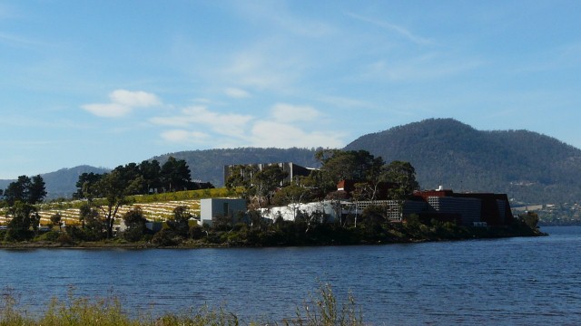
Quite a few people had recommended that we go to the Mona art gallery in Glenorchy which was on our way back. It is a new building in the middle of a vineyard, owned by a man called David Walsh. He apparently made his fortune through gambling and has built this huge gallery and filled it with unusual modern art, all owned by him. As you entered you were given an ipod which tracked your movements around the gallery and informed you about the pieces of art in your immediate proximity. The device told you about the artist and what the piece was about. Sometimes there were interviews with the artist or comments from David Walsh about why he bought the piece.
Whilst some of the art was quite main stream, other pieces were very risque. Many would find them shocking or even offensive. He seemed to like buying up art that other galleries had shunned. We spent a really interesting 2-3 hours there and would recommend it highly. The best thing was it was all free.
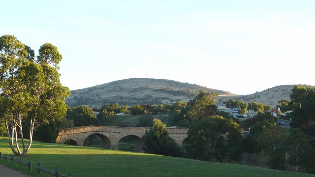
The ride back from there to Richmond took us up a long steady climb following the valley over grass tree hill down into the Coles River Valley wine region.
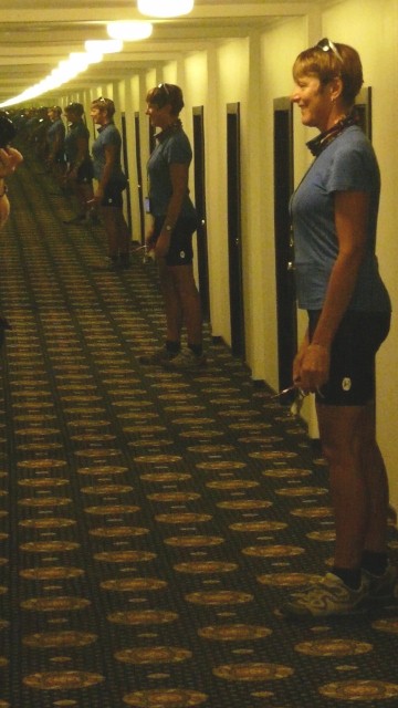
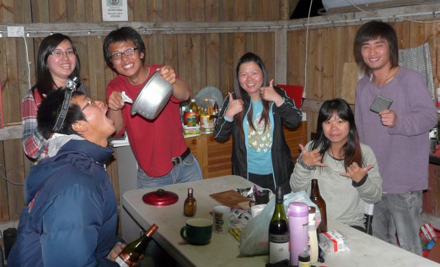
This was our last night at the camp site and we took the chance to get a team photo with Maggie, Gir, Wendy, Kiwi and the rest. Over dinner the cap on one of Steve’s teeth came off and despite using our emergency dental kit it wouldn’t stay on. We needed to find a dentist.
Tasmania - Day 12 - Richmond to Triabunna
- Distance 63.3 km
- Max Elevation 320m
Tasmania - Richmond to Triabunna Ride Profile
Ride Description
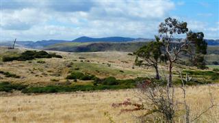
We rose to dense morning fog and the air was cool, but despite this we managed a relatively dry pack. Initially we followed the valley north out of Richmond and over hills to join the main A3. This road passes through beautiful forest and farmland but is narrow, winding, has no hard shoulder and climbs three significant hills with descriptive names, Bust-Me-Gall and Break-Me-Neck.
It also had log trucks, lots of them. They are all driven by testosterone fuelled men who drive faster than any other vehicle on the road. The trucks are so wide that on these narrow roads they have to drive with one wheel practically in the ditch. This makes it a bit dicey for us poor cyclists. They don’t like to pull out to pass and if they do the back end swings alarmingly in front of you as they pull in. They even intimidate the car drivers, pulling out to overtake and practically forcing them off the road. They have an instantly recognisable engine noise and as soon as you hear one approaching from behind you start looking for a place of safety, if necessary leaping into the ditch. And they don’t just pass you once, they spend all day driving back and forth between the forest and the mill.
Just before lunch Steve’s back tyre suddenly deflated. Once again it was a "pinch" puncture on the inside of the tube where it lies on the rim. He mended it and after another 500m there was a picnic area where we stopped for lunch. Ten minutes after setting off again it blew again. After applying another patch he was re-inflating it and it did the same again! Eventually we managed to get going with a new tube and low pressure.
For about 8km before Orford the A3 runs along the Prosser River gorge. Here the road is even narrower, running between a rocky cliff edge and a crash barrier above the fast flowing river. There is hardly room for two vehicles to pass let alone a hard shoulder. Incredibly we managed to get through the whole length without encountering a single log truck.
We camped at Triabunna and had planned to go on the ferry to Maria Island national park but at $35 each and extra for the bikes we just couldn’t afford it.
Tasmania - Day 13 - Triabunna to Swansea
- Distance 50.2km
- Max Elevation 100m
Triabunna to Swansea Ride Profile
Ride Description
Today the sky was cloudless and the sun was warm. We continued along the A3 but once we passed the wood-pulp factory there were no log trucks passing us. Karen had a puncture early on, caused by a splinter of glass in her tyre. The road undulated through farmland, mostly grass pasture.
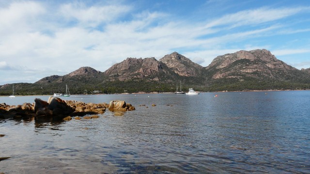
After 35km it dropped down to the coast again at Mayfield and we ate lunch on the beach. From there the road hugged the Tasmania coast all the way to Swansea, a pretty seaside town with some historic buildings and harbour.
Tasmania - Day 14 - Swansea to Coles Bay
- Distance 60.2km
- Max Elevation 180m
Tasmania - Swansea to Coles Bay Ride Profile
Ride Description
The tent was soaking wet with condensation this morning and had to be hung over the fence in the morning sun to dry. It was a fine morning but the forecast was for heavy rain later. Before setting off we had coffee in town and checked the e-mail so it was almost lunch time before we left.
Our route notes suggested a side-trip to the Freycinet Peninsular along Seven mile Beach from where we could book a ferry ride in a small dinghy to Cole Bay. This sounded quite exciting but when we rang the ferry man he told us the ferry service had ended.
Instead we had to ride around on the main road adding about 30km to our journey. The road was flat and the wind light for the first 20km which meant rapid progress. Then there was a slow 10km climb and with the increase in elevation came an equal one in the wind speed, head on of course. Arriving at the junction there had to be a conference, 14km straight on to Bicheno into the headwind or sharp right and 30km to Coles Bay with a back wind. We chose the second and had a flat ride with the wind helping.
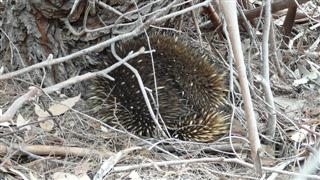
On the way Steve spotted an echidna in the undergrowth. Karen grabbed the camera, determined to get a photo and slithered down the steep bank in pursuit. The echidna, keen on self preservation, buried itself in the dry leaves at the base of a tree trunk. We sat down quietly nearby and ate our lunch waiting for it to emerge, but it refused to budge so the photo is just of its rear.
Further along the road there was a dead Tasmania Masked Owl, one of the biggest owls in Australia. It had only just died which seemed strange for a nocturnal bird and it may have eaten a poisoned animal. It had the most amazingly beautiful plumage and huge powerful claws.
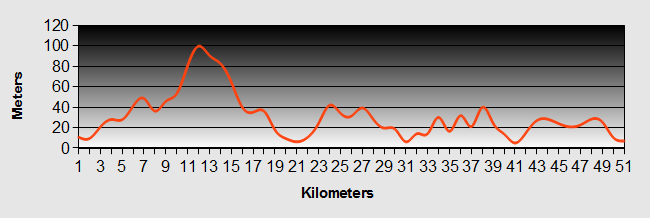
Tasmania - Day 15 - Coles Bay to Bicheno
- Distance 40.3km
- Max Elevation 60m
Tasmania - Coles Bay to Bicheno Ride Profile
Ride Description
Despite the pessimistic weather forecast there was just a short shower overnight and a clear sunny morning. We left all our gear at the camp site office and cycled into the national park to walk to the Wineglass Bay viewpoint. There was about 1km to walk, all uphill with a lot of steps. We suddenly realised how fit we are after this long session of cycling. All the tourists were toiling slowly up the hill, breathless and red faced, sitting down frequently, some even turning back, defeated. We almost jogged up and hardly breathing hard.
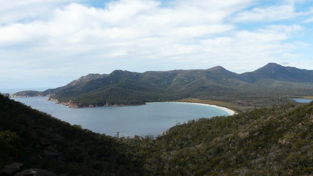
The view of the bay was lovely and it would have been good to have time to walk down to the beach but we didn’t have time. After picking up the gear we cycled back along the road towards Bicheno. Two cars passed us very slowly and then pulled onto the hard shoulder ahead. A familiar head popped out of the window. It was Maggie and the rest of the eastern Asians from the camp-site at Richmond.
Arriving at Bicheno we rode down to the harbour and found a sunny and sheltered seat to eat lunch. As we ate we discussed whether to continue further up the coast and camp at one of the beaches. Suddenly there were black clouds at the north end of the bay and within 5 minutes the rain reached us so we camped at Bicheno.
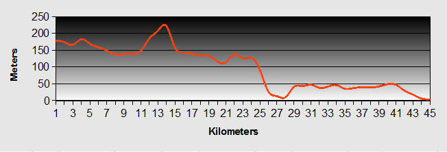
Tasmania - Day 16 - Bicheno to St. Helens
- Distance 74.9km
- Max Elevation 62m
Tasmania - Bicheno to St. Helens Ride Profile
Ride Description
The Tasmania rain and wind prevented us from getting much sleep. Having packed the wet tent we put on our full rain gear and set off for "the best cycle ride in Australia" according to the author of the Tasmania Giro tour. Well today it wasn’t. Low clouds blocked the views and strong cold southerly winds buffeted us constantly although most of the time they were at our tails. It wouldn’t be true to say it poured with rain all day, it did slow to a drizzle at least twice. We just put our heads down and turned the pedals, the rain pouring down our faces and dripping off our noses.
About 25km from St Helens we met a couple of cycle tourists battling towards us into the headwind and we were glad we were going north. At Scamander, the first town for 58km, we had to stop to get warm. We were both soaked to the skin despite our waterproofs and sat and steamed while eating fish and chips and drinking mugs of hot coffee. A local lady told us that the weather would get worse and that we shouldn’t try to ride any further but catch the bus to Launceston.
Arriving at last in St Helens we found the nearest backpackers and went to book in. reception wasn’t open until 4pm but another guest let us in to shelter. We got an en-suite double room with a BATH and filled it to the brim with boiling hot water to thaw out. There was no heating in the hostel so the wet gear just got spread around the bathroom to dry.
The next morning the rain was still pouring down so we decided to stay put, get Steve an appointment at the dentist to fix his broken cap, and book a ticket on the bus to Launceston the following day.
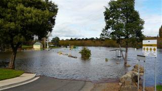
Steve’s appointment was at 2pm and by then the rain was even more intense. By 3pm the main road had disappeared under 6 inches of water, the hostel was like an island in a lake of water and the Tasmania fire-brigade had arrived to start pumping the water out of the flooded building opposite. Steve meanwhile had had to have his tooth root extracted and then wade back through a foot of water along the street. The hostel owner was getting very anxious as the flood was expected to get worse at high tide, due in 3 hours.
Luckily the rain abated soon after and the water level quickly receded. Our wet gear wasn’t drying so we asked for an electric heater which speeded things up.
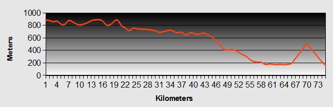
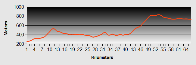
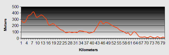
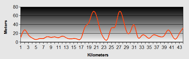
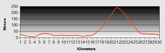
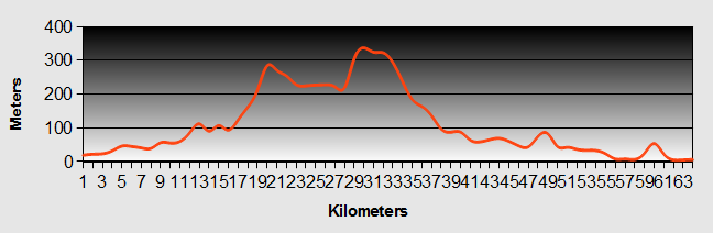
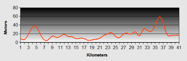
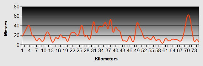
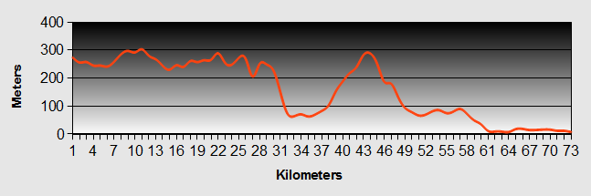
Tasmania - Day 17 - St Helens to Launceston (by bus)
- Distance 150km
- Max Elevation 920m
Tasmania - St Helens to Launceston Ride Profile
This part of the ride was by bus. As you can see from the profile above, it would makes sense to take two days over this section if travelling by bike.
Ride Description
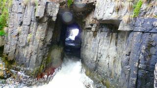
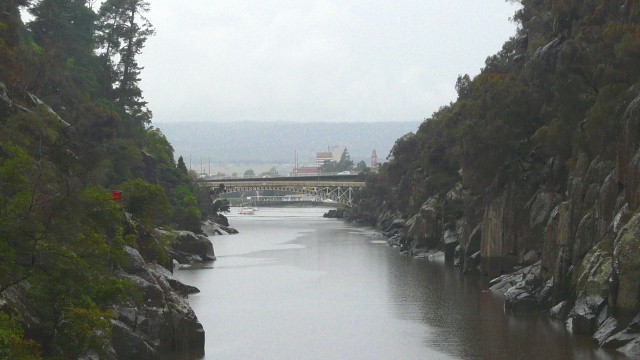
By morning most of the gear was dry and we packed and caught the bus at 8.30am. The bus went back through Scamander and across the Elephant Pass to Launceston. There were several landslides which had been cleared off the road and the rivers were all very high. In Launceston we booked into a Backpackers and spent the afternoon exploring Cascade Gorge.
Tasmania - Day 18 - Launceston to Exton
- Distance 47.4km
- Max Elevation 260m
Tasmania - Launceston to Exton Ride Profile
Ride Description
The Tasmania Giro Route said that it was flat all the way to Exton but it was quite a climb to get out of Launceston. By keeping to the old highway we avoided having to ride on the busy A1. At Hadspen the picnic site next to the river was a bit flooded so we continued to Carrick to eat lunch.
We had booked a couch surf in Exton, about 10km east of Deloraine, and Rob and Deb, our hosts would not be home from work until 4.30pm so we spent an hour on the internet at Westbury library. Rob’s house was on the top of hill above Exton, overlooking the Western Tiers which looked beautiful in the evening sun as we rode up to the house.
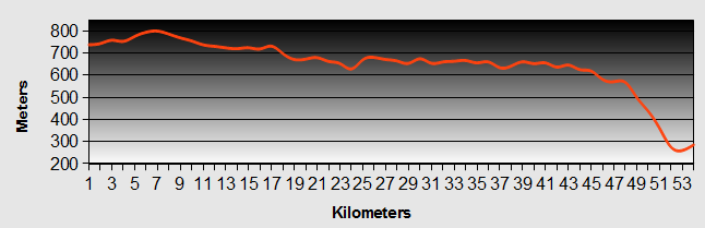
Tasmania - Day 19 - Exton to Devonport
- Distance 72.5km
- Max Elevation 300m
Tasmania - Exton to Devonport Ride Profile
Ride Description
Rob cooked us egg and bacon for breakfast before he went to work. It was another clear cold morning and there was only a short section of riding along the busy A1 before we could turn off along a minor road through farmland towards Railton, where we were on our first day, and back down the Mersey river valley to Devonport.
Getting back onto the ferry in Devonport was more complicated than the departure from Melbourne. All foot passengers had their luggage searched before boarding, and then had to walk through a metal detector (but the bags were not x-rayed) We’re not sure if the car drivers were subject to this also but it all seemed a bit pointless, it was just passing from one state of Australia to another.
The food was good and the crossing calm and we arrived in Melbourne refreshed and ready for the next leg of our journey.
New! Comments
Have your say about what you just read! Leave me a comment in the box below.