Cycling New Zealand's
Beautiful Coromandel Peninsular
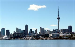
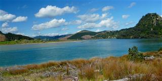
The Coromandel has to be one of New Zealand's most beautiful areas, with lovely walks over the hills and around the coast and yet within a short ferry ride from Aukland.
Schedule
Our ride descriptions give an account of the ride that we completed. As part of the description we also provide links to Wikiloc or Google maps and elevation profiles based on mapping data available through the internet. The ride profiles are smoothed to give what in our opinion is a more beneficial view of the profile. We use paper maps, GPS and on line data to plan and conduct our rides. We are happy for you to use our descriptions, but be aware that we do not guarantee the accuracy of the information provided as situations surrounding any ride change over time.
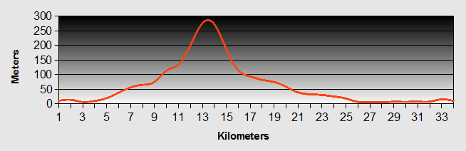
Coromandel - Day 1 - Auckland to Waiheke Island
- Distance 51.1 km
- Max Elevation 80m
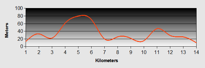
Coromandel - Auckland to Waiheke Island Ride Profile
Ride Description
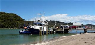
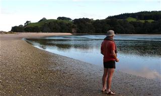
Rather than cycle round the mainland coast, Oliver suggested taking the ferry. It goes from Auckland via Waiheke Island. We took the Fuller's Ferry to Matiatia Wharfe at the west end of the Island.
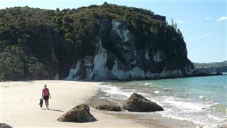
The route took us through Oneroa where we shopped for supplies. From there we took the main road to Palm Beach past the up-market houses with stupendous views over the ocean. This was the start of the hill climbing. At Palm Beach we ate lunch by the side of the gently lapping sea, overlooking the lovely quiet bay.
While we ate lunch we considered our options for camping. The only camp site on the island was at Rocky Bay, at the end of a 4km dead end road. This meant that if we stayed there we would have a hard 20km ride in the morning to catch the ferry at Opariu at the eastern tip of the island. Having no detailed map and with poor road signs, we took the Rocky Bay road when we should have taken the road to the Whakanewha Regional Park. This took us down to the bay at the opposite end to where we should have been. To get to the camp site we had two options, either climb back up the steep hill or take the footpath around the bay. The path was narrow and rocky through the bush and we had to push the bikes. It came out onto the beach which was loose broken shells and sand and it was almost impossible to push the bikes across.
Eventually we got back onto the road that we should have taken originally and another steep up hill. Halfway up Karen's back tyre blew again! Tempers were short and humour was even less so. After a quick repair we were about to set off when Karen realised that she had lost her rear view mirror, but she knew not where.
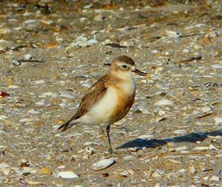
There was nothing for it but to get to the camp site. While Steve cooked the dinner, Karen walked back along the path looking for the lost mirror. She came back dejected and empty handed. However she did see six very rare New Zealand nesting Dotterills, which partially made up for it.
Coromandel - Day 2 - Waiheke Island to Coromandel Town
- Distance 28km
- Max Elevation 144m
Coromandel - Waiheke Island to Coromandel Town Ride Profile
Ride Description
The following morning we had to be up at 6-30 to catch the 9-50 "360Direct" ferry to Coromandel, It was only a 20km ride, but up three of the longest and steepest hills that we had ridden in New Zealand to date.
We rode hard and fast and were within 4km of our destination when disaster struck in the form of another puncture in Karen's back tyre. ***!!! As quickly as we could we fixed the problem and carried on, almost exhausted. We reached the crest of the last hill and Steve pedaled on in front to hold the ferry. 500 meters away the road forked one down hill the other up and no sign to the ferry. Which road to take? It was a 50/50 choice. The wrong way would mean missing the ferry. He opted for the left fork, which thankfully took him to the wharf,' puffing and panting but breathing a sigh of relief as the ferry hadn't even docked. Karen was quickly on his treads and came screaming onto the wharfe minutes later.
The ferry was about 15 minutes late, so our mad dash had been unnecessary, but at least we caught it. The crew had to lift our bikes aboard and then it was a pleasant 40 minute cruise to through the islands to Te Kouma Wharfe followed by a 10km flat ride to Coromandel Town.
The ride to the town was upsetting. As we cycled along Steve spotted a pair of pukeko birds with a pair of gangly, furry chicks running around by the side of the road. He called Karen back to look. As we watched, our moment of pleasure turned to horror as an SUV came along. One of the youngsters ran into the road and caught a fatal blow. As it lay fluttering about its parents came up and prodded it and sniffed in bewilderment. We could only watch, stunned by the tragedy of the scene.
We stayed at the YHA Tidewater Tourism Park which happened to have a deal with the Admiral Arms pub offering dinners at reduced rates. It was also the day of the Melbourne Cup horse race. We watched the race in the pub and enjoyed the shouts of jubilation from those few who won their bets. The beer was good and the food was plentiful.
Coromandel - Day 3 - Coromandel Town to Colville
- Distance 23.5km
- Max Elevation 160m
Coromandel - Coromandel Town to Colville Ride Profile
Ride Description
It was a wet and miserable start to the day. You could hardly see across the bay, but very soon the rain abated and the rest of the day was dry and sunny.
Before leaving town we had to visit the bakery to buy pies for lunch. The road then winds its way out of town and up the valley to the first climb of the day. The ride was mostly along the coast with a couple of big climbs along the way and good views across to the Motukawao Group of Islands.
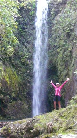
It was a short ride and we arrived at Colville Farm, our camp site around 2pm. The site is a working farm which has been in the same family for over 100 years. There are lots of nice walks up into the bush to see the old gold mine with its glow worms and to three different waterfalls.
But before we could enjoy the countryside we had to take a 1km ride into Colville to the local store, which is a tourist attraction in itself. It stocks everything (just about) from petrol to tent pegs as well as food and beer, the essentials.
Next door there just happens to be a nice little cafe with a couple of cakes that had our names on them.
Household chores completed we rode back up the valley about 3km to the start of the walk to Umangawha Falls. We locked our bikes to a tree and set off through grazed meadows full of cattle and a docile bull, (he was happy, he had lots of women about). There used to be a footpath all the way up the river to the waterfall, but it was washed away in the 2002 floods. The only way to the waterfall now is to scramble up the river bed, which we always find great fun.
We had gone prepared, in our trainers, knowing that we would get wet. It was a hard 40 minute scramble over boulders, pools and rocky banks. It was worth the climb and of course we had to have a brief dip in the lovely, but cold pool.
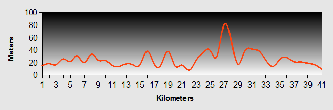
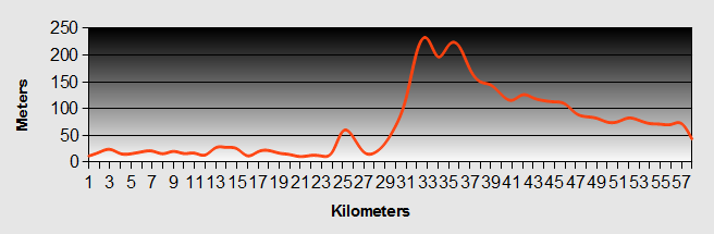
Coromandel - Day 4 - North Coromandel Loop
- Distance 67 km
- Max Elevation 210m
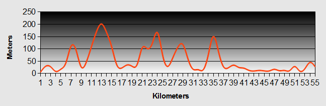
Coromandel - North Coromandel Loop Ride Profile
Ride Description
A complete contrast to yesterday, with wall to wall sun from the start.
For once we were not traveling onwards and could leave the tent and our gear at the camp site.
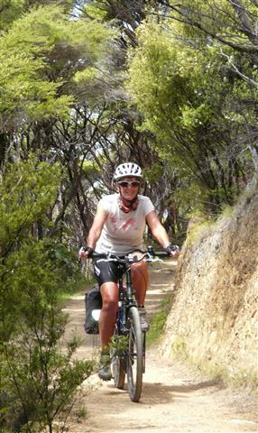
With our lunch and swimming things packed we set off for a long days ride on gravel roads and along the Coromandel Walkway.
Three kilometers beyond Colville the tarmac stops and the gravel begins, as it starts the long winding ascent over the mountains along the spine of the peninsular. Although we had no gear, the gravel still meant that we were into 1st gear at many places and the down-hills were slow because of the loose surface. Once over the main Coromandel ridge of mountains there is then another long climb back up and over again to reach the small hamlet of Port Charles.
We stopped at the Tangiaro Kiwi Retreat and Cafe for a "tres" nice but v expensive coffee and cake.
The Retreat is a lovely, quite and tranquil place set in its own grounds away from the road. At this time we were the only visitors and the lady on duty took time to explain to us about the different types of Kiwis and played us their calls. She described the female call as being like "a vomiting cat".
From there the road did not have so much loose gravel, but it was continuous ups and downs as it went from one bay to another. First we reached Sandy Bay which was... well.... sandy! Next was Rocky bay which was ... well... Rocky!
At Stony Bay ( you can probably figure out what this bay was like), the road ends at the DOC camp site. The Coromandel Walkway wound along the coast all the way to Fletcher Bay. It is a designated footpath, but bicycles are also permitted, although it isn't easily apparent.
Looking towards the hills you cannot discern where the footpath goes. Given the extreme gradients of the valleys that lead down to the sea, the path is surprisingly level as it follows the contours. The sunlight was streaming through the tree ferns and tall bush trees as we rode, listening to the unusual bird sounds of New Zealand.
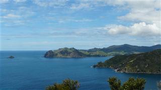
The views were spectacular. Looking due west beyond Great Barrier Island was the vast, blue Pacific Ocean and nothing until the coast of South America.
To the south we could look back towards Port Charles, the bush covered Moehau Mountain and the rest of the Coromandel in the distance.
To the North, in the direction of our walk was the Needles.


A very steep, loose gravel and winding descent takes you down to Sea level at Poley bay followed by an equally challenging ascent up the other side of the valley. This section was unrideable for us, although younger, braver riders would love it.
We only saw four pairs of walkers along the route and there was really no problem with having bikes on the same path as walkers. Having said that it would be different in the height of the summer when we are sure it would be more busy and also in winter when it would be very wet.
After the ascent by foot from Poley bay the path finally comes out into open farm land, passes by the Needles and comes down to a small sandy bay where we went for a swim. Then it was up over the next brow to reach Fletcher Bay and the DOC camp site. From here it was back onto gravel road.
After the first couple of long high climbs, the road flattens out somewhat to follow the coast. It is a beautiful ride with Pohutukawa trees giving shade and the sea always on the right. The only problem was that we were tired and the road was very rough. Even though it was flat our average speed was only about 12km/hr. It still took us two hours to do the last 26km, before the relief of reaching tarmac road again.
We had left at 9-15 and got back at 19-00. It had been a long ride and we were ready for dinner, Ibruprofen and an early night.
Day Off
The farmers wife had told us about an old goldmine half way up White Star Hill where we could see glow worms. After a morning's chores we set off on the bikes across the farm land, locking them to a fence before we started the climb up the 33% gradient hill on foot.
After 40 minutes hard climbing, the path dropped down across a steep ravine, with a gradient of about 50% and up the other side it was a hand over hand climb to reach the mine entrance.
Our efforts were rewarded as we groped our way into the darkness and saw about a dozen glow worms clinging to the roof of the cavern, like star constellations.
We continued up to the ridge of the hill at 600 m, with spectacular views of Kennedy Bay on the Pacific Side of the Coromandel Peninsular.
When we got back at the hostel, a young French couple had arrived and proceeded to bake chocolate chip cookies, bread and piles of crepes for the five of us staying there.

Coromandel - Day 5 - Colville to Coromandel Town
Ride Description
Today we retraced our tracks along the western side of the Coromandel as the only alternative was a long, steep gravel road back.
We stayed at the same camp site as before because they had a great deal with the Admiral's Arms for food and we needed another cheap meal.
As we rode onto the site there was a tent exactly the same as ours, pitched in exactly the same place that we had vacated a couple of days earlier. It belonged to a British couple, Charlie and Mel, who were over in New Zealand on a 1 year work visa. They were doing some traveling by bicycle before finding work. Charlie's bike had a trailer and two large front panniers, a total load of 65 kilos, which we felt was excessive.
Coromandel - Coromandel Town to Flaxmill Bay
- Distance 33.6km
- Max Elevation 290m
Coromandel - Coromandel Town to Flaxmill Bay Ride Profile
Ride Description
There are two possible routes to Whitianga on the Pacific Coast of the Coromandel. The first is along the sealed, highway 25 but it begins with a steep climb up to about 400m and is longer than the alternative by some 15km.
We chose the 309 road which is an easier gradient, does not go so high, but is gravel for about 2/3rd of its length.
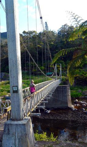
Having ridden the gravel road around the north of the Cormandel peninsular, we were concerned that it may be difficult with our full loads. We needn't have worried as it was much easier than we expected. The gravel was more compacted and smooth in many places. It was still a hard climb, but through magnificent scenery with next to no traffic. Along the way we stopped to see the Waiau Falls and yet more Kauri trees.

Lunch was eaten at the side of the river with a deep pool. A family were also enjoying the stream. The kids were swinging on a rope, playing on old inner tubes in the water and jumping of the banks into the pool.
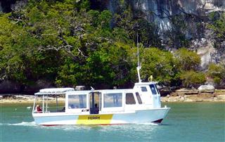
From here it was a flat ride into Whitianga which sits on the side of the estuary feeding into Mercury Bay. It is a typical seaside town with a nice atmosphere and the beautiful long sandy beach known as Buffalo Beach. At the river mouth is a little wharfe from where the tiny ferry operates on demand, taking foot passengers the 150m across to Ferry Landing.
Our bikes were manhandled aboard and before we had time to warm our seats we were getting them off again.
From Ferry Landing we had just a 1km ride to the Hideaway Camp Site at Flaxmill Bay. This bay is small, but uncommercialised with lovely walks to the top of Shakespeare Cliff, Lonely Bay and Cook's Bay. It was from the top of this cliff that Captain Cook recorded the transition of Mercury across the sun.
The camp ground was officially closed because they were building a new reception, but we were allowed to stay there for no charge, by the really friendly manager, Carl.
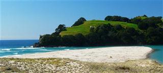
Lonley Bay is as it sounds. We were the only folks there on a golden sand beach with a back drop of sandstone cliffs and mature pohutukawa trees. We couldn't resist the temptation to swim.
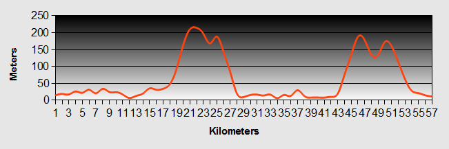
Coromandel - Day 7 - Hot Water Beach and Cathedral Cove
- Distance 40km
- Max Elevation 90m
Coromandel - Hot Water Beach and Cathedral Cove Ride Profile
Ride Description
In the morning we got the ferry back over to Whitianga to buy new rim tape for our wheels, as we suspected that this was a possible cause of our inner tube rupture problem.
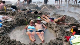
In the afternoon, we took the opportunity to cycle without our gear. We packed our lunch and swimming things and set off to catch the low tide at Hot Water Beach.
This is one of the Coromandel's and New Zealand's most visited beaches, where for two hours either side of low tide, an area of sand is uncovered where hot water bubbles up from two springs (Maori and Orua) below the surface. Traditionally people take a spade and dig themselves a spa pool. The water can get up to 64 deg C.
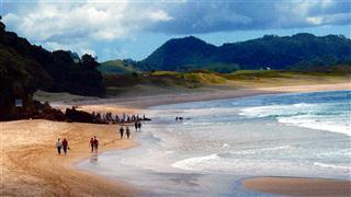
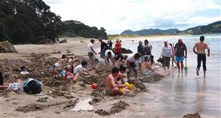
We rented our little green spade and joined the hundreds of other tourists, old and young alike to dig our pool. It seemed that a coachload of young backpackers had got there first and already staked their claims to the best spots. For us wiser owls however, it was pretty clear that they would tire of it soon and leave their holes for in preference for a pint at the local cafe.
Without lifting a finger we purloined a hole and lay down to enjoy the waters.
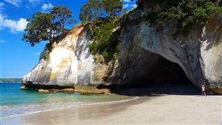
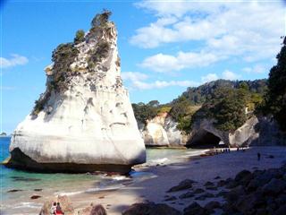
After bathing there was time for a Magnum, before setting off towards Cathedral Cove. This is another of the Coromandel's main attractions. To get to the Cove you have to park your car/bike at the car park and hike down the cliffs for 30 minutes, but first you must climb a very steep hill, about 100m, to reach the car park.
The walk to the cove is through puri tree groves and native bush, eventually dropping down to the Mares Leg Cove. From here it is a short stroll along the beach and through the gigantic stone arch way to Cathedral Cove. The other popular way to get there is to take the sea kayaking tour from Hahei.
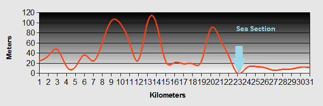
Coromandel - Day 8 - Flaxmill Bay to Opoutere
- Distance 54.6km
- Max Elevation 220m
Coromandel - Flaxmill Bay to Opoutere Ride Profile
Ride Description
The first part of today's ride retraced our steps, the same way we had been the day before, but we went past the turn off to Hot Water Beach continuing towards highway 25. At this point Karen's back tyre developed a flat. We repaired it and fitted the new rubber rim tape that we had purchased in Whitianga.
The road was more or less flat as far as Whanuakite when a gradual climb started taking us up 200m. Descending the other side we stopped at Tairua to shop and ate our picnic lunch at the side of the river estuary, looking across to Pauania with its large expensive houses; the holiday homes of the Auckland high fliers.
The plan was to camp at a basic DOC camp ground at Hikuai and consequently we had stocked up with overnight food. We stopped at a garage to ask directions from a courier service driver. He warned us that the site was a 4km ride up a gravel road and had no facilities. He suggested instead that we should continue along highway 25 and over the next hill to a much nicer site at Opoutere. As we set off to tackle the Opoutere Saddle, which the driver had assured Steve was only 100m, but Karen knew the guide book said 236m, there was a frosty silence between the two of us as we toiled in the blazing sun over a steep hill with our added heavy load of shopping.
Once we turned off the road at the bottom of the hill, it was obvious that it had been worth the effort. We rode along a peaceful estuary with just a few houses and mountains on both sides providing good shelter.
There was a sand bar at the mouth of the estuary with only a small outlet, meaning that it was not used as a harbour. The still waters were so clear your could see the bottom. There were lots of fish and sea birds. The camp site was near the mouth of the estuary, separated from a deserted ocean beach by sand dunes and ancient pine forest. The sand bar is a Dotterill nesting site and as such is restricted.
That evening we sat on the beach watching the tide seep into the estuary whilst Dotterills and Oyster Catchers flew and chattered around us.
As we sat there two dogs, a golden retriever and a black Labrador, both kept coming and swimming in the water and shaking themselves near us covering us in wet sand.
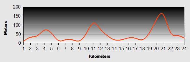
Coromandel - Day 9 - Opoutere to Karangahake
- Distance 57.3km
- Max Elevation 230m
Coromandel - Opoutere to Karangahake Ride Profile
Ride Description
We were not in a hurry to leave this morning as we wanted to get a photo of the bay in the morning sun at high tide. So it was 10.30 before we departed. The road was flat all the way to Whangamata, a very commercialised seaside town, we much preferred Opoutere. As we sat and had a coffee, a couple of motorcyclists from Waihi stopped to chat to us.
There was only one big climb today, 200m over the Waihi saddle. As we toiled up the hill a descending female driver shouted encouragingly to us out of her window 'good on yer'.
Waihi is famous for its massive gold mine and we climbed to the top of the hill to look down into the massive gaping hole created by the open cast mine.
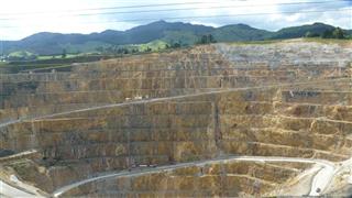
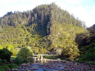
From here the route took us onto SH2, a busy highway with lots of lorries and fast cars. The road follows the Karangahake gorge, a beautiful valley which separates the Coromandel range from the Kaimai range. Scattered along the valley are lots of old gold mining relics, but we were so busy concentrating on our safety along the busy road we didn't have time to appreciate it.
We had booked a room at the BBH hostel in Karangahake village at the western end of the gorge and were relieved to get there.
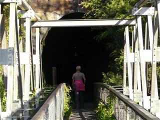
Before supper we walked along the old mining railway, which is now a walking track. The town was an important gold producer in the late 19th and early 20th century.
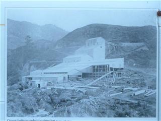
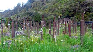
There were three huge processing plants, extracting gold and silver from the mined rocks, as well as all the supporting infrastructure for the factories. At its height the village had a population of over 2,000.
Today all that remains are a few foundations of the factories and the original railway bridges and tunnels, hidden among the regenerating bush and forest. The village now has a population of 85.
If you enjoyed our Coromandel page, why not have a look at some of our other Cycling in New Zealand trips, such as:
Cycling Up To Mount Cook
New! Comments
Have your say about what you just read! Leave me a comment in the box below.