Cycling the Wonderful Outer Hebrides
We had a yen to cycle around the Outer Hebrides for several years. Karen and I moved to Inverurie, just north of Aberdeen on the East coast of Scotland in March 2007. We had always wanted to see more of Scotland and this was our chance. Karen bought a book called The Ultimate Scottish Cycling Book by Paul Lamarra. This is a comprehensive guide to cycle-touring in Scotland and has rides in the lowlands, highlands, east, west and of course the Outer Hebrides. The ride around Mull sounded enticing, but the Outer Hebrides really attracted us. Travelling to some of the western most isles by sea and then island hopping from one to the other by ferry sounded just up our street. We also gained good insight from Gilbert Summers' website, Must See Scotland
The Outer Hebrides, or Gaels as they are known locally are not the westernmost point of Scotland, but they are still a 6 hour ferry ride from Oban, which is the main staging points for trips to the both the Inner and Outer Hebrides. A number of further ferry hops and causeways link the more southern of the Outer Hebrides islands, Barra and Vatersay via South Uist, Benbecula, North Uist to Harris and Lewis. Another attractive thing about the Outer Hebrides is that it is possible to wild camp, as long as you are sensible, don't cause a nuisance and take your litter with you.
Where to Start from and Getting There.
From Inverurie we could drive, travel by bus or train and could depart from various places on the Scottish West Coast. We felt that it would be nice to go south from Harris down to Barra, the southernmost of the Main Outer Hebrides, but we read that the prevailing winds were predominantly from the south to south west. So we changed our plan and decided to head North from Barra instead, finishing on the northern most of the Outer Hebrides islands, Harris and Lewis. Of course that year the winds decided otherwise and we ended up cycling into a strong head wind all the way up Uist.
The best travel method proved to be by rail. We bought the Scot Rail Rover ticket now known as The Spirit of Scotland Travelpass, which provides for 8 days travelling out of 15 days by bus, Ferry or rail. So this option worked out the most convenient and cheapest. (unfortunately, these tickets are only valid for travel within Scotland, so if you are coming from outside the country you will have
Our route would take us by train from Inverurie (only two minutes from home) to Oban on the west coast via Aberdeen and Glasgow. The island hopping commenced with the Calmac ferry from Oban to Castlebay on the Outer Hebrides Island of Barra followed by the ferry to Eriskay and across the causeway to South Uist. We then take the long western route up South Uist and across the causeway to Benbecula and onward through North Uist to the lovely small island of Berneray. Another ferry took us to Harris and finally back by ferry to Skye and the ride to Kyle of Lochalsh where we picked up the train via the Glen Carron, through Inverness back to Inverurie. A total of 15 days.
Schedule
- Trains and Bikes
- Oban to Barra and on to Vatersay
- Vatersay to Ludag, South Uist
- Ludag to Howmore
- Howmore to Shell Bay, Benbecula
- Shell Bay to Solas, North Uist.
- Solas to Bays Loch, Berneray.
- Berneray to Horgabost, Harris
- Harris to Uig, Isle of Skye.
- Uig to Carbost, Loch Harpot - Whisky time!
- Carbost to Sligachan
- Sligachan to Kyle of Lochalsh
Our ride descriptions give an account of the ride that we completed. As part of the description we also provide links to Wikiloc or Google maps and elevation profiles based on mapping data available through the internet. The ride profiles are smoothed to give what in our opinion is a more beneficial view of the profile. We use paper maps, GPS and on line data to plan and conduct our rides. We are happy for you to use our descriptions, but be aware that we do not guarantee the accuracy of the information provided as situations surrounding any ride change over time.
Outer Hebrides - Day 1 - Trains and Bikes
Taking a bicycle on the train is an adventure in itself. You are immediately the centre of attention with folk asking "Where you are going?" "How long will it take?" and on and on. The highlight of the train journey is the Glasgow to Oban section, which travels through beautiful scenery across the Firth of Clyde and touching along the side of Loch Lomond. The excitement rises as we approach Oban and slowly edge into the station right next to the ferry terminal. The place is buzzing with folk coming and going and we were impatient to be on the ferry to the Outer Hebrides.
We had booked to camp at the Oban Divers Camp site about 1 mile out of the town. After pitching the tent we headed back into town to find something to eat. We dined in a lovely contemporary fish restaurant right on the harbour and watched with fascination as young local lads and girls pulled line after fully loaded line of mackerel out of the harbour waters.
Fully sated we jumped back on our bikes and headed back to the tent, quickly diving inside to avoid the midges.
Outer Hebrides - Day 2 - Oban to Barra and on to Vatersay
- Distance 10km
- Max Elevation 35m
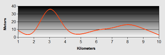
Outer Hebrides - Oban to Barra and on to Vatersay Ride Profile
Ride Description
Following a hearty breakfast, we packed and headed down to the ferry terminal to catch the lunch time ferry, but before that we sought out a camping shop. The fight with the midges the night before necessitated buying some repellent. While we were there, we found a great little table that was not too heavy and would come in useful for our tent.
It was a lovely sunny day as we headed out into the Sound of Mull, saying goodbye to Oban.We always get excited about riding on ferries and charged around like little kids with a new toy. After a while we settled down for the 6 hour journey keeping a look out for basking sharks and seals, the best sighting being just a shadow several hundred yards away.
 Oban
ObanArriving at Barra, the first of our Outer Hebridean islands, we alighted at Castle Bay about four pm. We bought some provisions at the local Coop and set off on the little road towards the small island of Eriskay, which is joined to Barra by a causeway. The road out of Castlebay climbs, what some would call a steep hill, but actually wasn't that bad. Looking back we spotted a someone cycling in the same direction that we had met on the boat. He was quite a long way back, perhaps a mile, so we didn't think to much of it and continued on. Along the way, we passed an old lady who was carrying a bag of seaweed on her back. Apparently it was good for her tomatoes!
 Castle Bay
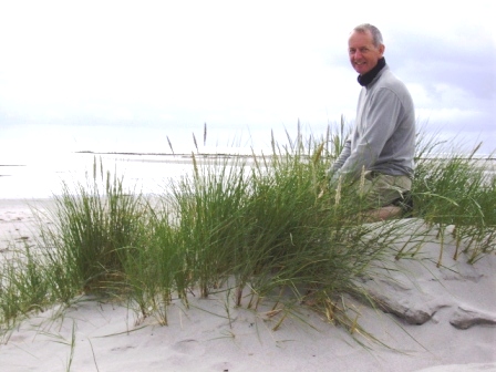
Getting closer to Eriskay we suddenly heard a bike behind us. Tom had caught us up in no time. This would turn out to be repeated several times throughout the two weeks. It was a good job that he turned out to be a really nice guy, otherwise I could easily have let his tyres down on more than one occasion. Tom is a very good amateur photographer. His web site, Lightpainter.co.uk is well worth a visit.
 Camping at Eriskay
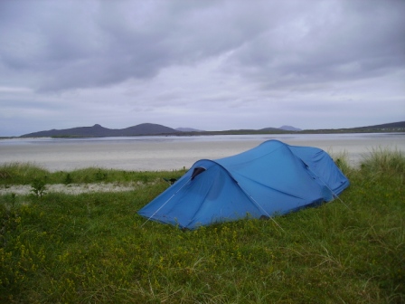
We cycled on together and found a place to camp on the top of the sand dunes overlooking the wonderful bay. We sampled our first ready meal on the Outer Hebrides - rabbit stew - delicious!
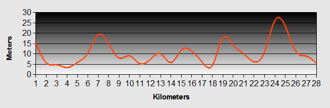
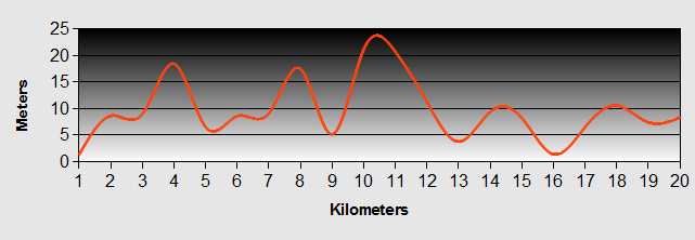
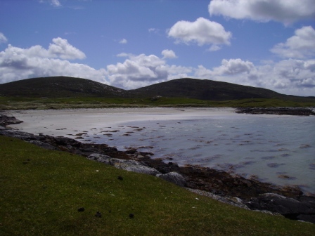
Outer Hebrides - Day 3 - Vatersay to Ludag, South Uist
- Distance 39km
- Max Elevation 83m
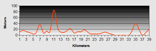
Outer Hebrides - Vatersay to Ludag, South Uist Ride Profile
Ride Description
The next morning was fine. We packed up and set off back towards Castlebay. Not far along and we stopped to view the remains of an RAF Catalina sea plane that crashed on the island in 1944. There were nine crew. Amazingly six of them survived.
 Wrecked Catalina Flying Boat
We continued along the single track road towards the airfield on the north of the island where we had a coffee and watched as the British Airways flight from Glasgow to the Outer Hebrides landed on the sand, taxied up to the terminal and the passengers walked across the sand. Fascinating!
 Barra Airport
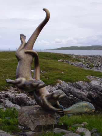
After a bit of a laze in the sand dunes in the afternoon sunshine, we got back on our bicycles and scooted down to catch the afternoon ferry to Eriskay. Time for another coffee and to admire the lovely bronze of two otters chasing a sea trout.
Once we had crossed the Sound of Barra, we were back on the bikes and soon over the causeway that joins Eriskay to South Uist. Turning right off the causeway we followed the road to find a nice little spot to camp on the machair. Once we had pitched the tent and had something to eat we walked back up the road to the nearest habitation to replenish our water supply. There was a guy watering his garden so we scrounged some water from him. He asked us if we had eaten and for a minute we though he was going to ask us in for dinner. He offered us some flounders that he had caught the day before. We accepted them with thanks and the following day ate them for our lunch, sitting on the beach. This would not be the first time we would be astounded by the generosity of the Outer Hebrides inhabitants.
Outer Hebrides - Day 4 - Ludag to Howmore
- Distance 28km
- Max Elevation 28m
Outer Hebrides - Ludag to Howmore Ride Profile
Ride Description
After lunch we set off into a strengthening wind, heading north west across South Uist which at 44 miles from North to South is the longest island in the Outer Hebrides. With a reasonably flat road it should not normally be a problem, particularly with the usual south westerly winds.. NOT!
The strength of the head wind kept our average speed to 4kph all the way as we battled up the A865. When we finally arrived at the Howmore Youth Hostel, run by the Gatliff Trust, it was blowing a gale. As the small camp site was pretty full, all of the best places in the shelter were taken, so we decided to get a bed in the hostel for the night. It was basic, but warm and out of the wind. We cooked our dinner in the warmth of the kitchen and joined the rest of residents around the blazing fire as the Outer Hebrides wind howled outside.
Outer Hebrides - Day 5 - Howmore to Shell Bay, Benbecula
- Distance 25km
- Max Elevation 13m
Outer Hebrides - Howmore to Shell Bay, Benbecula Ride Profile
Ride Description
After a leisurely breakfast and a late start we had a short ride to the next of the Outer Hebrides islands, Benbecula. We headed up the A865 and halfway to our destination struck off to the left at Lochdar towards the beach to take a rest on the sand dunes.
We passed by a number of typical Hebridean "black houses".These are the traditional houses of the Outer Hebrides with low, thick walls and thatched roofs secured by nets weighted with stones all around, designed to keep out the weather.
 Hebridean Longhouse
Then it was straight up the road, turn left just across the causeway to arrive at the Shell Bay Camping and Caravan Site. The wind was still blowing, but nowhere near as blustery as the night before. We pitched the tent around the back of the toilet block to get some shelter. The campsite is clean with good toilets, but otherwise unremarkable.
For our dinner we walked back along the road to the Dark Island Hotel for a beer or three and a dinner cooked by someone else. Good food,in a modern low rise hotel with a reasonable atmosphere, but not traditional.
Outer Hebrides - Day 6 - Shell Bay to Solas, North Uist.
- Distance 55km
- Max Elevation 27m
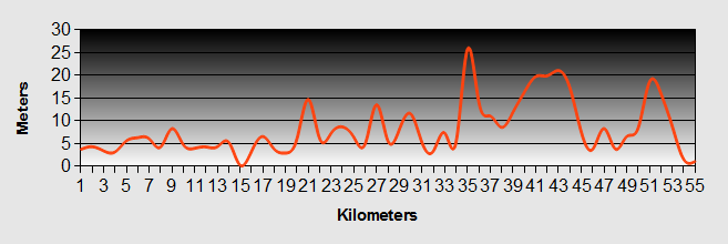
Outer Hebrides - Shell Bay to Solas, North Uist. Ride Profile
Ride Description
The next day we followed the minor coast B892 road around the west side of Benbecula, past the airport and across the causeway towards the next of our Outer Hebrides Islands, North Uist. We then headed around the North Uist, west coast road. On the way we came across the Hebridean Smokehouse. We just had to stop and sample their mouth-watering cuisine. The smokehouse produces, as the name suggests, various smoked products such as trout, salmon, etc. Needless to say we bought some and subscribed to their email list. Since coming home we have purchased more over the internet. Scrummy!
After we had taken our fill, we continued on our way, heading around the north corner of the Island arriving at Solas late afternoon. We saw a sign to a B&B off the main road at Solas. Arriving and knocking to enquire we were immediately put off the place as the landlady was very rude and the place stank of smoke. Apparently not all of the Outer Hebrides residents were as friendly as our first encounters.
So gladly we carried on to the sand dunes and pitched our tent. The bay at Solas is a lovely wide,flat stretch of sand. There was a group of teenagers there, who were sand yachting. Very impressive to watch. After dinner and a walk on the dunes we retired to bed. During the night, the wind got up and was probably the strongest wind that we had experienced during the week. We thought we were going to be blown away and understandably, we didn't get much sleep. I have to say here that our Lightwave Ultra G2 tent stood up to the gale very well and by the morning as the wind subsided we were still in one piece.
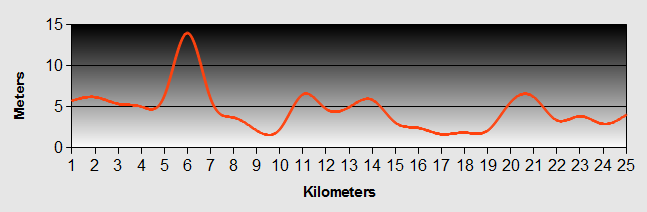
Outer Hebrides - Day 7 - Solas to Bays Loch, Berneray.
- Distance 20km
- Max Elevation 24m
Outer Hebrides - Solas to Bays Loch, Berneray. Ride Profile
Ride Description
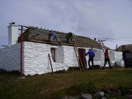
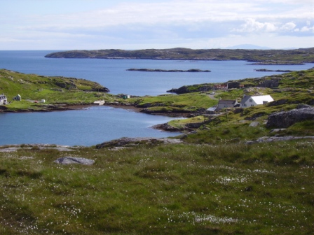
A leisurely breakfast (again) and we were back in the saddle. Today's was a short ride across the causeway to the lovely little Outer Hebrides island of Berneray. We headed around the beautiful Bays Loch to the hostel. This is another of the Gatliff Trust hostels. The Hostel comprises a couple of low, thatched roof, traditional black house type buildings.
When we arrived there was a team of three men who were re-thatching the roof. They were living in a caravan and would be there for the whole of the summer to complete the job.
The bay to the North of Bays Loch has a lovely long sandy beach and before dinner, we walked to the far end of the beach. Unfortunately we were on the wrong side to watch the sun go down so we walked back to the hostel for a tasty dinner.
We had elected to stay on Berneray for two days, as we had heard what a lovely little island it was. It did not let us down. The views across the Sound of Harris are just stunning. The next morning we set off for a long walk around the Island. We walked up past the old graveyard and stopped to read some of the gravestones. Then on and up over the top of the hill and down to the sand dunes on the other side. The beach there was lovely and the sea blue as the sky. We ended up walking probably further than we expected and eventually returned to the hostel feeling more tired than when we were cycling. I guess its just different muscles! We went to sleep that night with a great feeling of contentment. The Outer Hebrides ah!
Outer Hebrides - Day 8 - Berneray to Horgabost, Harris
- Distance 34km
- Max Elevation 42m
Outer Hebrides - Berneray to Horgabost, Harris Ride Profile
Ride Description
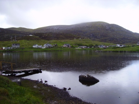
The next day we cycled back to the ferry terminal and caught the mid morning ferry to Outer Hebrides island number six - Harris. there were numerous seals basking in the warm sunshine on the islets in between the islands. Eventually we arrived in Leverburgh and circled around the small loch just as it started to rain. Fortunately there was a tourist office and cafe where we could shelter and sample the local cakes and or course, some tea.
After the rain had subsided we set off again following the main A859 around the western side of the Island.
We marvelled at the lovely bay formed out of the sandy ismuth that joins the main island to the headland of Toe Head, basically an island of one small mountain at about 1200m high.
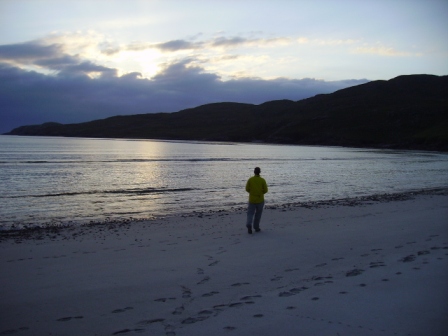
We continued along the coast road skirting the sea and then started to rise towards Horgabost passing by the golf course and eventually came to the stunning bay that looks across towards the island of Taransay, where the BBC filmed its first Castaway series and where Ben Fogel started his media career.
We had earlier met up with our old friend Tom from Barra and together we pitched our tents on the top of the sand dunes. That night was just magical as the sun set over Taransay. We cooked our dinner and ate as we sat watching the sun set in the west and a massive basking shark glided through the clear shallow waters. Later we watched a couple of sea otters swimming around the rocks while being dive-bombed by a flock of terns, anxious to keep us away from their nests. The bay was so quiet and scenery so beautiful that we decided to stay for another night.
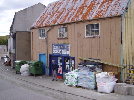
The next day we climbed the long hill towards the east climbing forever, up past the mountains that form the northern most part of South Harris, and then down the hair-raising descent to the port of Tarbert to do some shopping and have a look around. Here we spotted the most wonderful general hardware store that looked like it must have done 40 or 50 years ago at least. Visiting the Outer Hebrides really is like going back in time!
After a short snack we headed back up the hill and then down the east coast of South Harris. This side of the island was very different to the west, more rugged with stoney coves and beaches. There are scattered houses and hamlets along the way and a single track road with hardly any traffic. We took our time enjoying the views and the ups and downs of the deserted road. Nearing the southern coast of Harris we saw the sign to Rodel Hotel (now closed). We had read about this place and it sounded enchanting. We just had to take a look. By this time we were ready for a beer and something to eat. The location of Rodel Hotel is lovely. Down the hill and right next to the harbour at Rodel. The menu was created by the devil himself to tempt weakened cyclists. We succumbed to their gloriously cooked local seafood. Even worse we discovered Berserker! This amber nectar was created by the Hebridean Brewing Company an Export Pale Ale at 7.5%ABV, to add that final nail in the coffin that totally destroys a cyclists legs.
We ate and drank our fill and relaxed for a while to recover before climbing back up the hill. With legs like jelly we lost track of the time it took to get to the top and start the rather meandering ride back to the campsite some 15 miles away. We can't quite remember how we actually got back but get back we did. Our dreams were deep and sweet that night. Outer Hebrides, Australia, Mars - we could have been anywhere. We didn't really care very much.
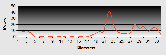
Outer Hebrides - Day 9 - Harris to Uig, Isle of Skye.
- Distance 19km
- Max Elevation 130m
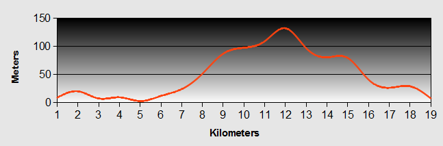
Outer Hebrides - Harris to Uig, Isle of Skye. Ride Profile
Ride Description
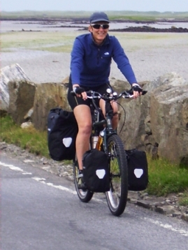
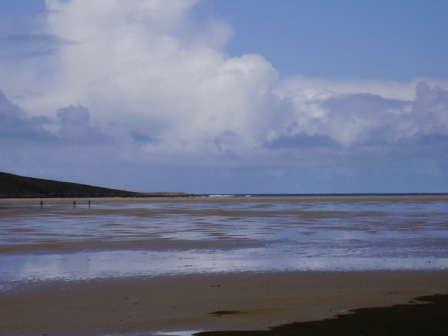
Luckily we could lie in a while the next day as we didn't have to catch the ferry from the Outer Hebrides to Skye until 14-00 hrs. The night before had taken its toll. However, after (another) good breakfast we set off up the hill for the second time in as many days arriving at Tarbert in time for a light bite at a local cafe whilst we waited for the ferry (Do we really seem to be eating all the time?). Half way through tea and scones, a young, handsome, dreadlocked and tanned guy entered with his equally attractive, blond and tanned girlfriend. They eyeballed us and headed straight over. "Hey man, are those your Thorn's outside?". We didn't get their names, but it turned out that he was a freelance journalist doing some work for Cycling Magazine, touring the Outer Hebrides, the opposite way that we had come. They had trialled our bikes a few weeks before on behalf of the Magazine so they were really interested in what we thought of them. How could we resist! Two hours later, we had to make mad dash for the ferry and only just made it.
The Outer Hebrides gradually faded into the distance and after a ferry ride of about 1 hour 40, we arrived in Uig on the Isle of Sky. We had pre-booked a B&B. Rolling off the ferry, there it was, right in front of us. The landlady was good enough to let us use her washing machine for our dirty clothes. After an afternoon of washing, bike servicing and generally lazing about, we took a walk around the bay to a pub some 30 minutes walk away. Afterwards as we headed back to our accommodation it started to pour with rain. We had no waterproofs and by the time we got back we were soaked to the skin. Still we dried quickly.
Outer Hebrides - Day 10 - Uig to Carbost, Loch Harpot - Whisky time!
- Distance 53km
- Max Elevation 155m
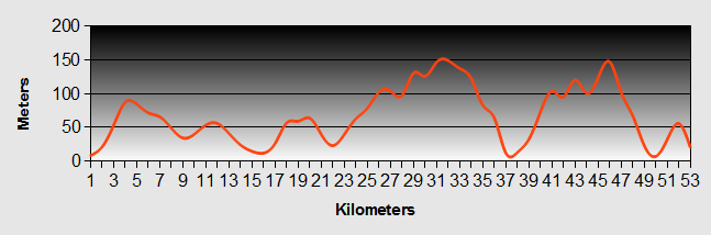
Outer Hebrides - Uig to Carbost, Loch Harpot Ride Profile
Ride Description
Next day started with the full Scottish. Not the best thing for starting the day on a bicycle, but hey we could take it. The road ascended out of Uig along the busy (at least by Harris standards) A87 main road. We arrived at Carbost, but not the one we were destined for. This was just a small village along the way and it marked the point when we cut off the main road and headed across the moorland towards Bracadale on the Western side of the Island. From Bracadale we skirted down one side of the Loch Harport to the crossing point at the head of the Loch and then along the other side to Carbost. Here we had pre-booked a couple of nights at The Old Inn and BunkHouse. Why here? Well it is the home of Talisker of course! We had developed a taste for Talisker several years earlier, when we had spent a week caravanning in Oban and it rained non-stop. Needless to say we spent a lot of time in the camp-site bar that had a very good top shelf and an expert to tutor us in the art of whiskey tasting. Talisker developed into a firm favourite and the opportunity to visit the distillery was too good to miss.
The Old Inn and Bunkhouse also turned out to be an excellent find. The inn itself is right by the Loch and you can sit looking across the loch as you sample their fine ales. The accommodation is in a new build bunk house next door, which is very well equipped and laid out. It is also used by groups of people walking the challenging Cuillin Ridge. The Cuillin Ridge is on a par with some of the best routes in the Alps and makes a great trek and climb in summer or winter. There are numerous guides on The Ridge. Needle Sports Guide is a useful source of information. A group that was staying there had been trying to get up the ridge for the previous three days without success due to low cloud and rain.
The following day we left our gear at the Bunkhouse and cycled through Glenbrittle forest to the camp site at Glenbrittle Bay just for a look see. It was great to be cycling without weight again. Glenbrittle is were most of the Ridge climbers start from, finishing at the Sligachan Hotel on the opposite side of the island, but there are detours to other munros along the way.
That evening, back at the Inn, we were entertained by the guy who runs the place who played his fiddle for about an hour or so, with no other accompaniment. Amazing!
Outer Hebrides - Day 11 - Carbost to Sligachan
- Distance 13km
- Max Elevation 80m
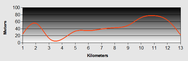
Outer Hebrides - Carbost to Sligachan Ride Profile
Ride Description
The next day was a very short ride to the Bunk House at Sligachan. We were there early enough to leave our gear and take the bus ride into Portree, Skye's capital. Portree is a lovely little sea side place and we spent the rest of the day looking around. We walked around the bay to the famous Cuillins Hotel and sat drinking an ice cool beer as we took in the breath-taking panorama which encompasses the isle of Raasay across the water and the spectacular view back towards Portree Harbour.
Later we sauntered back into Portree and down to the Harbour. We spotted a poster for a concert of contemporary and traditional Gaelic music at the Aros Centre. The Aros Centre is just south of Portree and is an exciting arts and culture venue. But first we had time to have dinner (food again).
We found a lovely little mediterranean style restaurant on the way back up from the harbour and had a relaxed meal overlooking Portree Harbour. We then took a taxi to the Aros Centre in time for the concert. The artist was Rachel Walker. It was a pleasant introduction to this type of music for us
After the concert we spotted the group of walkers that we had met at the Bunkhouse in Carbost and they were kind enough to give us a lift back to Sligachan.
Outer Hebrides - Day 12 - Sligachan to Kyle of Lochalsh
- Distance 41km
- Max Elevation 130m
Outer Hebrides - Sligachan to Kyle of Lochalsh Ride Profile
Ride Description
This was our last day of cycling before returning home and it was probably the least enjoyable of the whole two weeks. The ride was along the A87 main road which carries all of the car and lorry traffic across Skye to the ferry ports and on to the Outer Hebrides. The first part wasn't too bad but the closer we got to Broadford Bay and beyond the area had little to endear it. It was a relief to eventually find our way over the quite spectacular bridge from Skye to the mainland. We had decided to camp overnight. The site was a long climb out of Kyle of Lochalsh which was annoying as we would have to come back again to catch the train home the following day.
The next day we packed up our gear and headed back into the town, collecting a few gifts for our friends who had looked after our dog whilst we had been way.
The train journey from Kyle of Lochalsh through Glen Carron and The Strath Bran to Inverness was some of the best scenery that we had seen. We had a brief stop in Inverness for the next train to Inverurie and eventually arrived home in the early evening.
Our tour of the Outer Hebrides had been a wonderful two weeks, which we would highly recommend, but be ready for all types of weather!
New! Comments
Have your say about what you just read! Leave me a comment in the box below.