The Camino De Santiago - Route Del Norte And The Picos De Europa
The Way of St. James
The Camino De Santiago is probably one of the best known Christian pilgrimage routes. There are many questions surrounding the claims that St. James made his pilgrimage to Sanitiago de Compostela in the North-West Spanish province of Galicia and whether his body was actually carried there after his martyrdom. Numerous web sites discuss these issues and we aren't going to venture into that territory. Take a look at the Camino-De-Santiago.
Be that as it may, thousands of pilgrims follow the Camino-De-Santiago every year. They start their journey from all over Europe and there are now many officially recognised Camino routes, from different starting points.
The most walked, and probably the best known, is the French Route which starts from St. Jean Pied de Port just inside the French border in the Pyrenees. Many more Camino paths from much further afield, join up with the Camino Francais. Others come from different directions starting in such places as Morocco, Portugal and Italy.
The term "pilgrim" is used to describe the many walkers and cyclists that travel these routes to Santiago. As well as the true believers there are many who simply enjoy the walk, camaraderie, challenge or sense of purpose. For those that complete the Camino, as they stand in the Cathedral square, there is an incredible sense of shared achievement, elation and relief.
Getting There
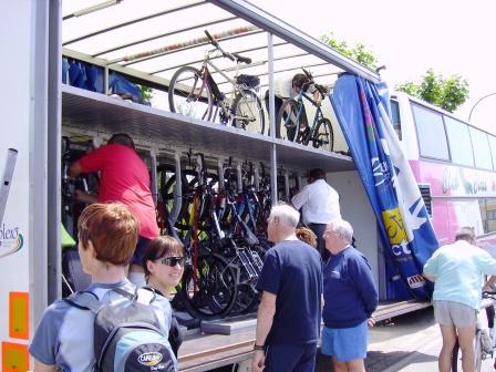
We took the Brittany Ferries route to Santander. The journey lasts 21 hours and currently the ferry departs the UK only on a Sunday at 16:30, arriving in Santander the following day at 13-00. Costs vary depending on your preferred mode of travel. We opted for a sole use cabin with en-suite shower/toilet. The food on board is good and there is plenty of entertainment, if that's what you like. Alternatively you can travel with Brittany ferries to Santander from Portsmouth. Whichever route you chose, it is a very relaxing way to travel.
Alternatively, Ryanair fly from Stansted. Their policy for bikes is as follows:
Ryanair Special Advice for the Carriage of Bicycles
The pedals must be removed (or fixed inwards) and the handlebars must be fixed sideways. The bike MUST be contained in a protective box or bag. It is not necessary from a safety perspective to deflate typical tyres found on bikes and wheelchairs for carriage in the hold. However, to eliminate the small risk of them being damaged by bursting, you may wish to deflate the tyres.
If you fancy doing a longer Camino de Santiago ride it is possible to get the Bike Express bus that travels from Cleveland, North England to Bayonne on the French Atlantic coast, close to the Spanish border.
Be warned however this is a very long journey which personally we wouldn't repeat, but it is another option.
Your bike is carried securely in a trailer behind the bus along with all your gear, so you can be sure that it will arrive in good condition (no such guarantee on an aeroplane).
The journey takes something like 36 hours and there are a limited number of short stops for food.
Our Route
Our Camino de Santiago ride did not adhere strictly to the Camino-De-Santiago Del Norte route as that is designed for walkers. We also wanted to see the Picos De Europa mountains. The Camino de Santiago walking route starts from Santander and goes all the way along the northern coast of Spain to Ribadeo before heading southwest to Santiago.
Our Camino de Santiago cycle route would immediately take us inland from Santander venturing into the Picos, before heading back to the coast before Gijon and then more or less following the official walking Camino de Santiago route.
Schedule
- Day 1 Arriving in Santander
- Day 2 Santander to Los Llares
- Day 3 Los Llares to Some Random Colada
- Day 4 Random Colada to Panes
- Day 5 Panes to Las Arena
- Day 6 Las Arena to La Isla
- Day 7 La Isla to Gijon
- Day 8 Gijon to Soto de Luina
- Day 9 Soto de Luina to Pinera (nearNavia)
- Day 10 Pinera to Ribadeo
- Day 11 Ribadeo to Taramundi
- Day 12 Taramundi to Lugo
- Day 13 Lugo to Meride
- Day 14 Meride to Santiago de Compostela
Our ride descriptions give an account of the ride that we completed. As part of the description we also provide links to Wikiloc or Google maps and elevation profiles based on mapping data available through the internet. The ride profiles are smoothed to give what in our opinion is a more beneficial view of the profile. We use paper maps, GPS and on line data to plan and conduct our rides. We are happy for you to use our descriptions, but be aware that we do not guarantee the accuracy of the information provided as situations surrounding any ride change over time.
Camino De Santiago - Day 1 - Arriving in Santander
On the ferry we met Jimmy, another cyclist who was touring alone. He got on the ferry with an enormously loaded bike and several parcels on a trolley that he was pulling by hand. He had originally lived in Plymouth, but now lives in Menorca and had travelled quite a lot throughout Spain and Europe, so we took advantage of his knowledge.
He was expecting to be picked up by his girlfriend in Santander, but due to a change of plan he had to dispatch his parcels by post and cycle to Burgos to meet her instead.
We arrived in Santander 12-30 to pouring rain. Oh no!
We and Jimmy checked into the alberque in Santander (basically a bed in a dorm for the night, shared with walkers traveling the Camino-De-Santiago Del Norte). To be able to use these cheap alberques, you have to buy an official Camino de Santiago pilgrimage card which is stamped each time you stay at an alberque.
We signed up and officially became "Pelegrinos".
The alberque was managed by a rather stern looking lady who ran the place with an iron fist. There was no talking allowed in the dormitory and because we were cyclists (2nd class citizens in the Camino de Santiago club) we were allocated to the very shakey and squeaky upper bunks, only walkers allowed in the lower ones. We had a restless night and had to be up early and be out by 8-00am sharp otherwise you would be put into solitary confinement for a month.
It felt very much like the old style English youth hostels and we thought "If this is what the alberque's are like we would rather camp".
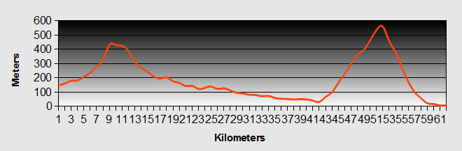
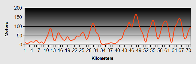
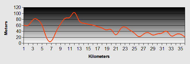
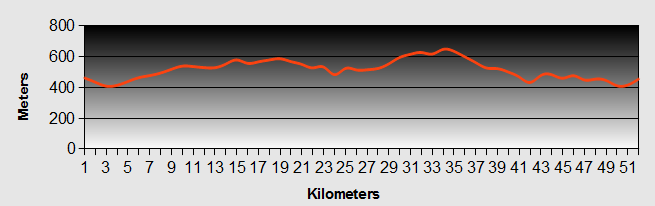
Camino De Santiago - Day 2 - Santander to Los Llares
- Distance 57km
- Max Elevation 454m
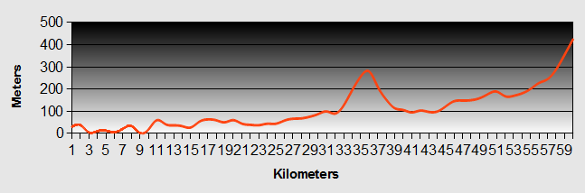
Camino De Santiago - Santander to Los Llares Ride Profile
Ride Description
It was still dark as we emerged from the alberque for the start of our Camino de Santiago ride, but at least there was a clear sky and it was going to be a sunny day.
We looked for the nearest café to have breakfast and then headed off to the tourist office to find information about camp sites and along the Camino de Santiago route.
The office wasn't much use so next we went to the bookshop to buy the Michelin 1:150,000 maps that we would need for our travels. Outside we bumped into Jimmy again and we opted to travel with him out of Santander as far as Saron, some 20 kilometers due south of the city.
The Camino de Santiago route started along the busy main road, but as we came out of the main part of Santander the traffic became less heavy and we transitioned into rolling green countryside. The sun was shining and it wasn't a bad ride.
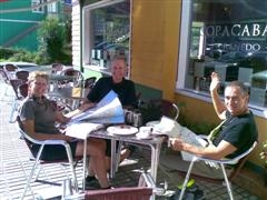
After approximately 10 kilometers we should have turned off to Saron, but we all missed the turning as the numbering was different to what we had read on the map. Having realized our error we decided to continue to Puente Viesga instead, stopping for lunch in Renedo along the way.
While we ate lunch we checked the lonely planet guide book for the opening times of the Cueves del Castillo that we were heading for and realized that they were closed on Tuesdays in the low season. So the caves were out!!
We arrived in Puenta Viesga, said goodbye to Jimmy and took the N623, turning right out of the village to climb our first real Spanish col along the CA170 to about 500 meters amidst beautiful scenery. It wasn't too high or steep. It was easily manageable, but hot and sweaty.
Flying down the other side we dropped down to Los Corrales de Buelna, which was quite industrial and then along the Rio Basaya Gorge as far as Arena de Iguna. Turning off we took the CA 804 towards Los Llares.
This route is not on the Camino de Santiago, but it was a route documented by Elizabeth Wagstaff on the CTC website and had been compiled in 1992. We were unsure how much of it had changed since then.
The Pasada de Cantabria was very nice but at 75 euros we thought "no!"
Try as we might we couldn't find any reasonably priced accommodation and eventually, after some local help, headed for the hills and the promise of a National Parque picnic area with free camping.
This turned out to be another climb of about 500 meters, which at the end of the day we could have done without, but it was through a lovely wooded valley. We finally arrived and set up tent at the picnic area, fully kitted out with barbeques, tables, toilets and water supply. We cooked a lovely meal of fresh sardines, green beans and potatoes followed by yoghurt.
The temperature had plummeted and we needed all of our cold weather gear on to keep warm as we ate our dinner by torchlight. Once we were tucked up in our down sleeping bags we were warm enough and passed a peaceful night.
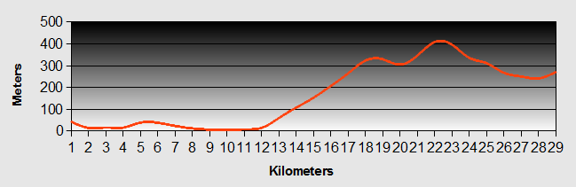
Camino De Santiago - Day 3 - Los Llares to Some Random Colada
- Distance 35km
- Max Elevation 927m
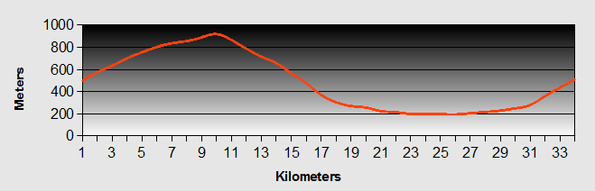
Camino De Santiago - Los Llares to Some Random Colada Ride Profile
Ride Description
It didn't get light until 8-00am and it was very cold. Karen braved the cold first and got up to make some tea. We were up and about quickly and cooked and ate a hearty breakfast. However, the sun didn't begin to clear the trees until about ten o clock and the tent was very wet with dew and condensation so it took a lot of drying out. It was 11-00am before we actually set off on our Camino de Santiago route to complete the rest of the climb that we had started at the end of yesterday.
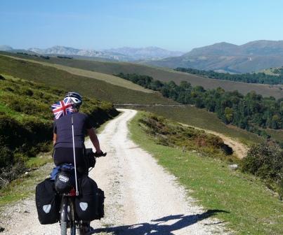
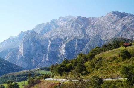
The tarmac section to the col was through beautiful moorland, which reminded us of Scotland with heathers, gorse, scabious and autumn crocuses along the route. It was manageable, but long and quite hot. From there the Camino de Santiago route turned into a rough, but ridable track still climbing, turning and eventually reaching a slightly higher col at about 940 meters, before descending again.
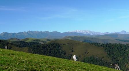
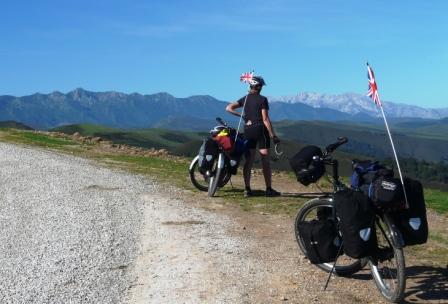
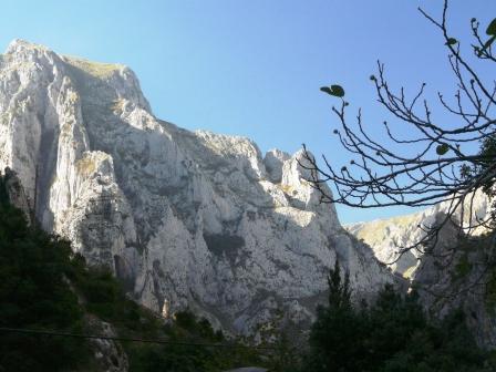
It was also the first real view of the Picos de Europa. The ridge of peaks looked like teeth in a bad state of decay, jagged, gray and brown, shining in the afternoon sun.
The descent was down a rougher and steeper track, so it was brakes on all the way to reach our destination. It was also notably the first time that we had met any Spanish mountain bikers and we met three within a few minutes of each other.
At the bottom, we stopped in the village of Ucieda for lunch, which was delicious, well needed but pricey. While we were there a Spanish gent came over and talked to us in good English. It turned out he had lived in Stourbridge for four years during his twenties and in fact met his English wife there. At her request they had moved back to his village and lived there for forty years.
Before leaving we stopped in the store next to the café and purchased something for dinner. They didn't have much choice so we opted to buy a ready sauce and pasta; quick and easy. In the fridge they had an interesting looking, locally made sauce that was vacuum packed. It appeared to contain tomatoes with salami and other stuff that looked like chicken. It was called "Callos".
From Ucieda we turned south down the CA-180 as far as Valle de Cabuerniga. We knew there was a camp site here, but didn't know if it would be open or not. It was, but on enquiry the price was 23 euros per night, which we thought was extortionate for a single night, out of season.
So we turned around and instead continued on our Camino de Santiago route up the valley on the CA-182, a long and arduous climb in the afternoon sun. After an hour or so climbing steadily, we reached the collada (at we think 650m) with views across the Picos and found a place to camp wild again for the night in a copse of trees just off the road. So as not to draw too much attention we waited to pitch the tent till dark and instead set about cooking our dinner as we watched the stunning sunset of the jagged Picos.
We dug out the tantalizing sauce and pasta bought earlier. As water was limited, we decided to cook the pasta in the sauce. As Steve tipped the sauce into the pan he realized our mistake. Callos = tripe!!! There was nothing for it we just had to make do. So it was all cooked up, with a little red wine added. In fact it was surprisingly average, but edible. It was filling and neither of us could eat it all, not just because it was tripe! We cleaned our bowls with bread, had desert, tea and chocolate. Next we erected the tent, got everything inside and sat down to write the blog, before retiring to bed.
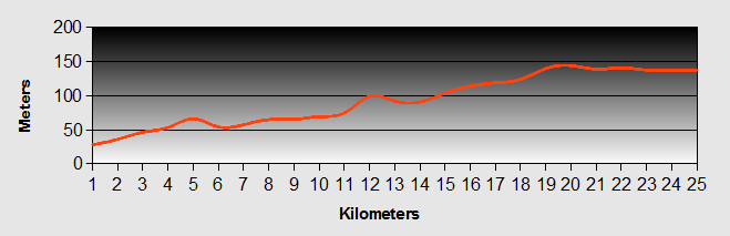
Camino De Santiago - Day 4 - Random Colada to Panes
- Distance 26km
- Max Elevation 244m
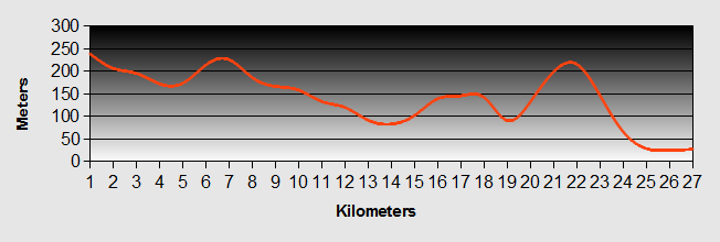
Camino De Santiago - Random Colada to Panes Ride Profile
Ride Description
The following morning the tent had condensation inside and dew outside. We got up and hurriedly made some breakfast. We had no spare water to wash either ourselves or our pots and pans. We dried the tent as best as we could, but wanted to clear the site as quickly as possible, so we finished packing and headed off on the Camino de Santiago route down the valley. It was a long descent about 5km with a 500m drop. It was very cold and we needed our full thermal gear on.
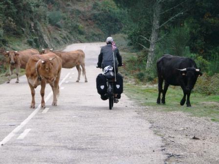
We arrived at the bottom of the valley in the village of Puente Nansa and stopped at the river to wash our dirty pots in the water. Job done, we continued onthe Camino de Santiago route up the next climb to reach the Collada de Hoz at 658m where we stopped for lunch. We were entertained watching a couple of farmers herding their cattle down the road.
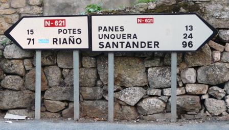
After lunch there was another long downhill stretch all the way to La Hermida where we joined the main road, the N-621. Here it was a question of "Pots or Pans".
Camino De Santiago- Day 5 - Panes to Las Arenas
- Distance 22km
- Max Elevation 152m
Camino De Santiago- Panes to Las Arenas Ride Profile
Ride Description
Steve's birthday today, 54 years old! Ben had suggested paying for a night in a hotel as a present so we were expecting another comfortable night.
We packed our things and set off on the Camino de Santiago route by 10-00am. We bought some fresh bread, pan au chocolate and water for breakfast before heading out of town on the AS-114 towards Arenas de Cabrelas. The going was easy and traffic light as we wove our way up the valley surrounded by the magnificent Picos mountains. After a few miles we pulled into a lay-bay to brew up and eat breakfast.
We continued on the Camino de Santiago route and eventually reached a campsite just short of our destination. We enquired about the price, which was reasonable at 15 euros, but we had already decided to stay in accommodation tonight so we went on to Arenas de Cabrales. This was a more tourist oriented town than Panes and there were plenty of bars, cafes, shops and different types of accommodation. With the help of the tourist office we found a pension offering a room for the night for 25 euros.
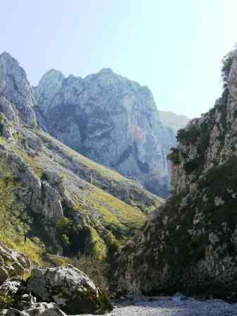
We checked in, changed and as it was only about 13-00 we decided to take a stroll up the valley to Poncebos. Unfortunately we had to walk on the road, but we wandered up through the narrow gorge with its tantalizing, blue river, which cried out "swim in me". We ate our lunch by the river, but the water and wind were just too cold to contemplate a paddle let alone a swim.
The walk was about 6km and we continued up the valley a little further on a rough track before turning around and heading back to Arenas de Cabaleros. We spent the rest of the afternoon relaxing in the sun and thinking about our options for our next stage of our Camino de Santiago ride. Over the last few days the realities of camping at altitude in Northern Spain at this time of year had begun to hit us. We had so far been lucky in that the weather had been dry and sunny every day. However, the overnight drop in temperatures, the time taken for things to dry out in the mornings and for the temperature to get up to a reasonable level were proving to be a real problem.
At the same time, the costs for food and accommodation in Spain were also a lot higher than we had expected, which was compounded by the falling value of pound against the euro.
It was time for some difficult decisions to be made.
We decided to head for the coast to pick up the Camino de Santiago walking route to see if it was any warmer at sea level. Hoepfully the riding would be a bit easier as well.
Camino De Santiago- Day 6 - Las Arenas to La Isla
- Distance 58km
- Max Elevation 581m
Camino De Santiago- Las Arenas to La Isla Ride Profile
Ride Description
After a good night's sleep, we packed our gear and went out prepared for the mountain cold. Following breakfast in a local café, we set off on the Camino de Santiago along the main road towards Cangas de Onis. Although the sun was shining it was very cold, circa 6 degrees. Initially the run was flat along the valley so we didn't start to warm up until we began to climb up the valley several kilometers later. As was becoming the norm, once the sun was high in the sky we stripped down to shorts and T shirts and we had a lovely run into Cangas.
Cangas is a bustling tourist destination with a thriving adventure sport industry, such as kayaking, quad biking, climbing, canyoning, etc.
We sat and ate our lunch in the park by the river which over looked the old Roman bridge.
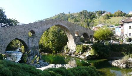
We chatted to an old man and woman on the park about our Camino de Santiago ride. They were perturbed at our plan to cycle through Arriondas and over the pass at Mirador de Fito to La Islas on the coast. They tried to convince us it was far too steep and high to manage with loaded bikes and we tried to tell them that we had done much more challenging hills already and it wouldn't be a problem.
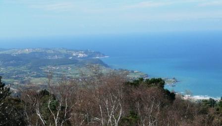
However we did set off with some trepidation. We needn't have worried too much. It was a long but gentle 10km climb up to approx 650 meters.
At the top, the views back to the Picos ...
...and on to the coast were stunning, but the haze meant that photographs did not do it justice.
There followed an exhilarating descent to La Isla. We were once again on the official Camino de Santiago route. We arrived in the sleepy seaside village and cycled past the only open café, in search of the alberque de Pelegrinos. We had a fruitless wild goose chase around the village, asking several locals for directions all pointing to a house in the village. The house had the Camino de Santiago Shell symbol on it so we knew we must be in the right place, but we couldn't raise anyone. We went back to the road to find a shop to do some shopping for tomorrow's lunch (as it was Sunday). The lady directed us to keep through the village to the left.
We eventually found the alberque. It was closed with a telephone number to ring. We tried the number, but realised we needed to insert the Spain dialing code, which we didn't know. We made a quick call to our son, Simon to get the code and then tried again. We couldn't get any answer. We tried several times, but by now it was getting dark, so we thought "Damn it". We pitched our tent in the alberque's garden. We tried to phone one last time and got through, but couldn't make ourselves understood. So we cycled to the house to find the Senora and eventually got the message across. She took us to the alberque and let us in, which was warm and clean. At that time we were the only occupants.
She was confused about the tent, but we moved all of our stuff inside and then headed off to the café to get something to eat. On the way there we met an elderly, tired looking, German walker who was obviously on the Camino de Santiago trail, so we gave him the key to the alberque as he already knew where it was.
The café was the center of the village life, full of locals watching the football and the grand prix, playing cards and dominoes. We ordered Platos Combinados (steak, chips, egg and salad including red wine and bread all for euros 7.80).
As we ate, a young cyclist came in with a huge back pack and a T shirt wrapped around his head to keep warm. He communed with the barman and then headed out. We realized that he must be looking for the alberque so we accosted him, got him back inside and plied him with red Wine on the promise we would show him where it was. "AC" as he was known to his friends is from Belgium, but had lived in Spain and studied the language. We took him to the alberque and we all settled in for the night.
Las Islas was a lovely little place, which clearly in the summer must be a buzzing seaside town, but at this time it was quiet, to say the least. There were many holiday homes that were locked up for the winter. The hotels were closed and the café was the only place of any activity.
Camino De Santiago - Day 7 - La Isla to Gijon
- Distance 52km
- Max Elevation 185m
Camino De Santiago - La Isla to Gijon Ride Profile
Ride Description
Before setting off onour Camino de Santiago ride we prepared for a cold morning, with full cold weather gear on, but as it turned out, apart from a brisk wind, it was a lot warmer than the mountains. We set off through the village hoping to get breakfast at the café, but it was closed, so we continued the three kilometers to Colunga to take breakfast there. As we were eating, our old friend the German Pilgrim came in. He had set off a good hour and a half earlier than us, but had been confused by the directions and ended up going the wrong way. Hence he had not got very far. We breakfasted with him and then set off again on the Camino de Santiago route along the N362 towards Gijon. Due to the new motorway, the traffic on the main road was very light and the ride was a pleasure in the morning sun.
The countryside comprised orchard after orchard of apples used in the local speciality, "Cider" or Sidre as it is known in Spain.
We arrived in Villaviciosa, which is a big cider producing town, at approx 12-30 and needed to buy milk for our tea, but it being Sunday, all of the shops were closed. So we headed out of the town onthe Camino de Santiago ride up a long gentle climb and ate our lunch halfway up the hill.
The Camino de Santiago from there continued gently upwards and developed into a series of valley drops and climbs, eventually taking us off the main road and towards the beach at Gijon, where we hoped to find a camp site.
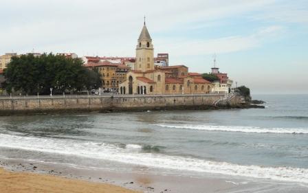
As we came into view of the city we realized that it was a very big place with an impressive sort of citadel.
The Camino de Santiago ride took us around the bay and down to the main beach. We cycled along the sea front and stopped to look for a pension that Karen had read about in our Footprint guide. We went to the street but couldn't find it. We decided to look for a camp site that was also mentioned, but along the way stumbled across the pension that we were looking for. We actually managed to make ourselves understood and booked in for three nights at 20 euros per night and a long earned rest.
We are writing our blog in the bar with free internet, just over the road from our pension.
Camino De Santiago - Day 8 - Gijon to Soto de Luina
- Distance 73km
- Max Elevation 178m
Camino De Santiago - Gijon to Soto de Luina Ride Profile
Ride Description
As we woke on Wednesday morning we thought, from the traffic sounds, that it had been raining and the shutters on our pension window didn't allow us to determine the state of the sky. We arose at about 8-30 and opened the shutters to find a clear sky and no rain. We packed our things according to a new order that we prepared especially for staying in the alberques meaning that we would only have to open two bags instead of four.
We paid our host, said our goodbyes and set off on the Camino de Santiago down the Calle San Bernard to the harbour where we picked up the designated cycle lane along the sea front. The lane continued and we were pleasantly surprised that it took us a good way out of the city. When the lane expired we stood wondering which way to go when an older cyclist spotting our predicament pointed us in the right direction. We followed his directions, but stopped within 200 meters to buy bread. He caught us up and started to reiterate his instructions in convoluted Spanish. A passer by stopped and joined in the conversation. He seemed to think we couldn't understand the other guy and that what we really wanted was food. He proceeded to tell us where we could buy good food. We looked on bemused as the two of them fought it out to give us their preferred form of advice.
Fully provisioned we set off along the Camino de Santiago again, following the cyclists directions. Leaving the town we came into an industrial area that was like something out of Gotham City. Steel works, pipes over the road, flyovers, etc. We cycled below them looking for the right road and were helped on our way by a fellow pilgrim walking along the road. We passed the industrial area and carried on along the main road towards Aviles. The road was straight and busy with gentle climbs and descents.
About 3 km further on we pulled off the main road to eat our breakfast. We had found a shop selling muesli, which with milk was very passable. We brewed up and sat and ate breakfast in the sun.
With renewed vigour we quickly completed the 18km on the N-362 coming into Aviles along the side of the river. The Camino de Santiago route was reasonably quiet and we passed a number of cyclists along the way, who all shouted their support.
Aviles had a lovely historical centre in the form of the Plaza de Espagna. We walked our bikes through the pedestrian plaza and stopped in the walled park in the town center to eat lunch. We watched the lunchtime joggers running circuits, elderly gentlemen walking and grandfathers taking their grandchildren to play on the swings. The park was bustling in the lunchtime sun as people finished work and prepared for the siesta. Afterwards we walked back into the square for coffee and use of the free wifi in the square to check our email.
After a look around the town we headed out of Avilesalong the Camino de Santiago towards our next destination, the alberque at Cudillero, (or so we thought).
Before Cudillero we decided to head down the hill to Playa de Aguilar as we still had plenty of time on our hands. We flew down the hill through pine and eucalyptus forest and as we approached the beach we were eyed by a woman walking her dog, who spoke in in English "Its good to see a British flag". We stopped and chatted to her about their difficulty in finding suitable sites for their camper-van. the road continued around the little bay along the sea wall. The Atlantic rollers were pounding the rocks and raising a mist of fine spray that clouded the area.
At the end of the bay road we found the lady's husband in their van just about to set off and look for her. We stopped him and chatted for another 5 minutes, by which time she had come along again. So we chatted for yet another five minutes. We then set off again for a steep climb out of the bay.
Half way up was a viewpoint. As we stopped to catch our breath a Spanish registered car pulled up and a young couple got out with their little girl and asked in English, where were we going. So we chatted for another 10 minutes. Waving goodbye we headed off to finish the hill and then back down into Cudillero, which we were assured was a "fun place that we would enjoy".
The town itself stretched down a steep hill to the harbour. We asked where the alberque was and were directed further down the hill. After a few minutes with no success we stopped again and asked a café owner. He said that the alberque was not actually in Cudillero at all, but in fact was in Soto de Luina some 10km further west and back up the steep hill that we had just sailed down.
Dejected and down hearted we turned around and set off back up the hill. Arriving at the top took us onto the busy main road again for several kilometers. It was not particularly arduous, but the traffic was heavy because this was a section where the new motorway was not completed so all the traffic was on the main road.
Finally we turned off and the final part of the Camino de Santiago route was an easy downhill to Soto de Luina.
We signed in to the alberque at the café in the center of the town. After settling into the alberque, we walked back into the town for something to eat. We decided against the café that only appeared to have snacks and instead walked to the end of the town to find a small bar that served food. We were amazed to find there was not only a set menu, but also a board of specials above the bar. With a combination of the phrase book and miming of the landlady we established that the choice included pig's trotters, pig's ears, tripe and liver. Surprisingly, dear readers, we went for the standard menu and had chorizo sausage, eggs and chips!
Satisfied and ready for a good night's sleep, we walked back to the alberque.
Camino De Santiago - Day 9 - Soto de Luina to Pinera (near Navia)
- Distance 54km
- Max Elevation 170m
Camino De Santiago - Soto de Luina to Pinera (near Navia) Ride Profile
Ride Description
There were a number of young, male Spanish mountain bikers in the alberque who were planning a long ride to Ribadeo so we had expected them to be up early. At 8-30 we thought we had better get up first as it was obvious no one else was going to make a move.
After packing and breakfast in the bar (coffee and cake), it was off up the hill out of town and back onto the Camino de Santiago. The hill took us back over the motorway and down again onto the old main road. The road was a great surface, next to no traffic and wound its way up and down the deep ravines, sometimes winding under the motorway and train viaducts along the way.
The sunlight streamed through oak, eucalyptus and chestnut forests casting a dappled pattern on the road before us. We came to a sign in the middle of the road saying road closed (pretty normal in Spain, but everyone ignores them). We carried on, past the road workers and stopped to have our second breakfast in a lovely meadow by the side of the road. The Spanish cyclists from the alberque passed us shouting and hollering as they went.
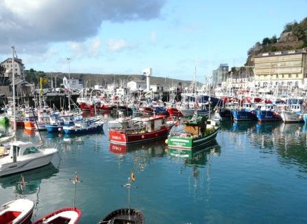
Our next port of call was Luarca, a lovely little fishing port. The harbour was full of small, modern and well kept fishing boats, in contrast to what we see in Britain. These boats were all inshore vessels, not the ocean going boats that we hear about coming to trawl for fish in UK waters.
We sat on the sea front drinking coffee.
Although the Camino de Santiago ride was very enjoyable, the continuous ups and downs were tiring and we were relieved to finally arrive in Pinera. The Camino de Santiago signs took us off the main road to the house were we had to sign in. A teenage lad answered the door. We signed the book and get our Camino de Santiago passport stamped. After a few mis-communications, we understood that he wanted us to give him a pen to add to his collection that was hanging from a string on a ceiling beam. We gave him a medical pen (one of Karen's free rep gifts) and he gave us another in return.
The alberque was an old school building on the busy main road. There was no bar or anywhere to eat so we bought food from a shop nearby and cooked a meal on our stove as the alberque had no kitchen.
Camino De Santiago- Day 10 - Pinera to Ribadeo
- Distance 35km
- Max Elevation 106m
Camino De Santiago - Pinera to Ribadeo Ride Profile
Ride Description
Today's Camino de Santiago route was a complete contrast to yesterday's. The ride was along the busy main road, with lots of lorries and fast cars passing us. There was no time or interest to stop and take photos. We were trying to get to Ribadeo, the first big town in Galica, before the tourist office closed at 13-00. Each Spanish region publishes its own information on the Camino de Santiago route and the alberques that lie along it, but you cannot get the information until you actually get to the region. So, it was just one hot and sweaty slog.
To get to Ribadeo we had to cross the Eo estuary or go around it via Vagedeo, a 25km detour. The only other way appeared to be the motorway. A young Belgian guy had told us there was a passenger ferry from Figueras. We stopped at a service station and the guy gave us good directions to the small town. He advised us there was no ferry, but that there was a foot bridge over the estuary. It wasn't clear to us where the bridge was, but after more enquiries we realized that it was at the side of the motorway bridge. Finding it wasn't easy and we spent 20 minutes trying to get to it.
Bridge crossed, we cycled into Ribadeo town center to find tourist information, which although it should have been open, was actually closed, until a young Spanish couple managed to find the guy and open it up. This chap clearly resented having been dragged out to open the center and was not very helpful. We got basic information and no acknowledgment that there was an alberque in Ribadeo.
So we went for another coffee and to check out the alberque web site that we had found previously. Sure enough, there was an alberque in the town. We asked the proprietor where it was and were given simple directions to find it. (****dy tourist information!)
Of course when we got there it was closed with a number to call to get the key. We promptly called and interpreted (wrongly) that we would have to come back at 9-00pm when he would be there to stamp our Camino de Santiago passport. We chased around the countryside looking for a camp site with no success and headed back to town to get something to eat.
The restaurant opened at 8-00pm so we had to have a beer at a bar in the Plaza de Espana. It was a lively atmosphere, whole families, from the youngest to the eldest where out enjoying the Friday evening warmth. We sat and watched the kids playing on their skate boards, the old men and women talking in groups and the teenagers parading. The Spanish still have that lovely all inclusive family style of living that we have sadly lost in the UK.
We had a hurried meal so that we could get to the alberque in time. When we arrived it was already open and a girl that we had met at the alberque the night before was there. She had been there since 6-30. The key had been hidden behind the public telephone all the time. So we could have got in when we first arrived, Duh! Anyway the alberque was new, comfortable and there were only three of us.
Karen was complaining about a sore throat, and spent the night shivering even though it was very warm. Steve was very worried about her and wondered what we may have to do if she got worse.
Camino De Santiago - Day 11 - Ribadeo to Taramundi
- Distance 28km
- Max Elevation 433m
Camino De Santiago - Ribadeo to Taramundi Ride Profile
Ride Description
During the night the wind had got up and we would have a strong southerly, warm, head wind to our next destination. Our Camino de Santiago route to took us through the mountain town of Taramundi, which according to the guide book was a beautiful, untouched rural part of Spain, and on to Lugo, a total of 90km.
Her throat and cold were no better. However, we packed and set off riding along the side of the Eo estuary, which could have been a Scottish Loch. It is beautiful. The view across to the old town of Castropol was stunning. At the end of the estuary we reached Vegadeo. Here we stopped to shop, and have breakfast. It was a typical busy Saturday morning with everyone rushing around doing their shopping. There was also a vintage car rally in the square.
With a new map for the final part of our Camino de Santiago journey through Spain we set off out of town up the valley to Bres. It was a long slow climb, made doubly hard by the strong head wind. Karen was struggling due to her cold. The guide book talked of a simple little road to Taramundi with cows and mule carts, but since writing it had been replaced by a broad, well surfaced modern road. There was still little traffic and apart from the strong wind and Karen's health, it was an enjoyable ride.
We finally arrived in Taramundi. It was about 3-00 when we arrived and it was obvious that Karen could not cycle much further feeling as she was. With the help of a local café girl, we found that the only accommodation open were the three hotels in the town. One of them had apartments at 36 euros. We took one. It was great. It had a kitchen, living room, bedroom and bathroom. Although it was a little more expensive, it meant we could cook our own food and as it had a washing machine we could do our washing at no extra cost. For Karen it was just what she needed, a warm bath and a good night's sleep. We were also pleased that we were not camping as it rained hard overnight.
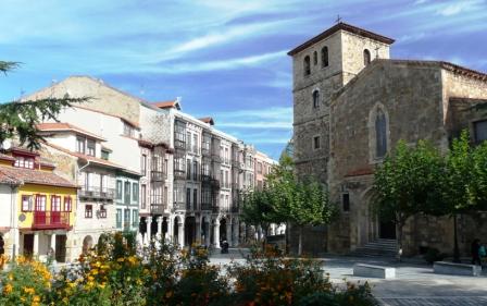
We were a bit disappointed with Taramundi. It was still a lovely mountain town, but it is now a tourist hot spot with a lot of Artisan gift shops, and tourist buses.
Camino De Santiago - Day 12 - Taramundi to Lugo
- Distance 63km
- Max Elevation 602m
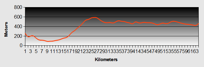
Camino De Santiago - Taramundi to Lugo Ride Profile
Ride Description
Our original thoughts were for our Camino de Santiago route to go to Lugo through the mountains, but it was obvious this would take us at least two days, so we decided to pick up the main N-640 that runs south from Vegadeo to Lugo.
The cloud was low in the valley. It was warm with a humid mist, but at least there was no wind. Karen was feeling much better and her fears of getting flu were unfounded. Despite the poor weather, the ride was enjoyable, being initially all downhill to A Pontenova on the main road, where the Sunday market was just starting up. As it was early Sunday, there was very little traffic on the main road, which had recently been resurfaced. It was a dream to ride on, but it was another long (10km) gradual climb to approximately 580 meters. The humidity made it uncomfortable, but it was compensated by the scenery.
Just after we crested the pass, a police car drove slowly towards us, passed us and then turned around. It crawled passed us again and looked to be pulling into the hard shoulder about 20 meters away. Our hearts sank as we thought some trouble might be brewing. We were relieved when it pulled away before we got there.
We flew down the hill into the town of Meira. There was a local car rally starting from the town square. Fortunately they were not going our way, and we carried on out of the town.
From here the traffic increased and the Camino de Santiago road was long, straight with continuous ups and downs, so the ride was less pleasant. Even then, we could pull off the road into a field have lunch and doze in the sun for half an hour.
We got to Lugo and made the climb up into the old walled citadel. The roman walls are impressive; high, wide and completely intact. We walked around in the warm evening. Lugo lies on the river Mino which eventually flows to the Atlantic Ocean and forms the border between Spanish Galicia and Northern Portugal.
We booked into the alberque, which was within the citadel walls. It was a very modern alberque and only 3 euros each, but it didn't have anywhere to put bikes. We had to lock them to a bike stand outside in the street which was a worry, (but thankfully an unfounded one).
We had dinner in a simple, local restaurant where we ate a delicious Dorado fish and patatas.
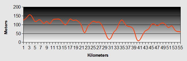
Camino De Santiago - Day 13 - Lugo to Melide
- Distance 51km
- Max Elevation 658m
Camino De Santiago - Lugo to Melide Ride Profile
Ride Description
We were out of the alberque before 8-00am and left the town through the roman walls at the Porte de Santiago. It was another misty still and humid morning. We left the town on busy main road, up the hill, stopping for first breakfast on the way, but as it was early there were no shops open at all.
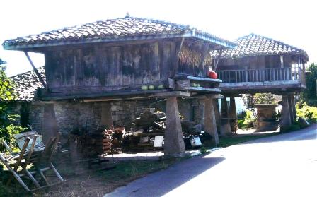
We crossed over the main N-540 Lugo to Chantade road, to follow the Camino de Santiago route along the back lanes through simple villages, where the agriculture was still very traditional. This was the rural Spain that we had been looking for , with age old oak forests, meadows and farms. Traditional buildings, stone walls and churches abounded. We noticed that the granary stores had changed from the shed on stone stilts to raised stone buildings with ventilated walls.
We rode on and on, but there were no shops, cafes or anywhere that we could buy food or water. It was hot and we were thirsty and hungry. We rode 37km alongthe Camino de Santiago before we arrived in Palas de Rei, on the main N-547 to Santiago. We immediately bought a litre of water and fell into a local hostelry for their "menu del dia". Suitably refreshed we carried on along back lanes and main road to reach Melide.
We were told that the alberque was closed for refurbishment and were directed to the alberque Provisional. After a little hunting around we rolled up to a massive warehouse type building with a roller shutter door open which was obviously the entrance.
We walked into a place that was about two football pitches in size. In the middle were stacked together, about 50 or so bunk beds. We thought "My God are we going to sleep in here?" It quickly dawned that within the warehouse had been built a prefabricated building to form the accommodation. It was very busy as we were now on the main "Camino de Santiago Route Francais". There were a number of other walkers with English as a first language for the first time since leaving Santander.
There were two dorms. A large one with about 50 beds and small one with only seven beds. We thankfully were put into the small one. We had no snorers and air conditioning. It was probably the best night we had had in a dorm.
The kitchen was fantastically fitted out, but no pots, pans or utensils. Fortunately we had our own. We shopped and ate a light meal before bed.
Camino De Santiago - Day 14 - Melide to Santiago de Compostela
- Distance 57km
- Max Elevation 465m
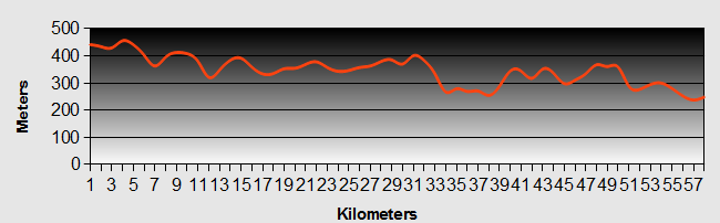
Camino De Santiago - Melide to Santiago de Compostela Ride Profile
Ride Description
Another early start. Out before 8-00am. Beautiful sunrise streaming in through the industrial windows of the warehouse. There was no real choice other than to go along the main road today unless we wanted a major detour through the hills.
The ride really has little to commend it. We stopped in Arzua to shop and have first breakfast. Later we lunched in a lay-by. Sounds naff, but actually it was sunny, warm and cheese and wine tasted good. As we were now getting close to Santiago we passed a lot of Camino de Santiago walkers and some cyclists.
The final part of the Camino de Santiago route took us up to Monte de Gozo, which on a clear day gives good views over Santiago. There is a large alberque here with its own restaurants, shops, camp site and several hundred beds in small dorms. However, it's a fair way out of the town and we wanted to stay in Santiago itself.
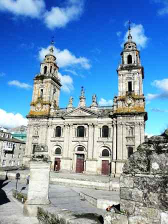
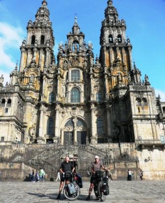
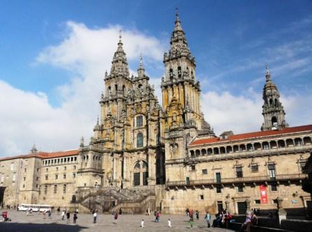
As we approached Santiago we were concerned that we may suffer the same disappointment as when we had visited Lourdes, France. The approach is through busy streets, but finally you come to the old town, with its historic, paved, narrow streets and multitude of original buildings centered around the cathedral.
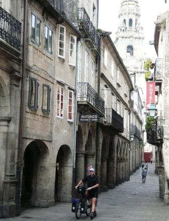
Santiago is a wonderful place, full of atmosphere and even in October it was very busy. Pilgrims arrive from different directions, from all over the World and gather in the Praza da Obradairo in front of the Cathedral. They rejoice in their safe arrival. Some have come for purely religious reasons, some for the cultural experience and others simply for the challenge. There is a combined and overwhelming sense of relief, satisfaction, achievement and camaraderie that moves one to tears.
We headed for the Oficina de Perigrinos to get the final stamp in our passport and our certificates for completion of the Camino de Santiago. Then it was to the Oficina de Tourism to find accommodation. We decided to pay the extra and booked into a pension in the town. We got a nice little double room with its own quite terrace.
Our excursion into the Picos de Europa and the Route del Norte had taken us just over two weeks. We had taken our time and enjoyed the ride. Undoubtedly it could be done in a lot less time by young, fit fanatics, but hey, remember...
Negotiating the rush hour traffic...
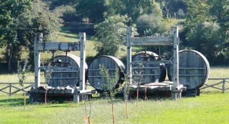
...Grain stores...
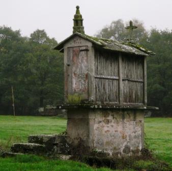
...The smallest shed on stilts...
New! Comments
Have your say about what you just read! Leave me a comment in the box below.