Cycling The River Saar and Rhein
from Luxembourg to Basel
From Luxembourg we headed south down the river Saar before cutting east following the canal to link up with the Rhiene at Strasbourg and finally down to Basel in the north of Switzerland.
Schedule
Our ride descriptions give an account of the ride that we completed. As part of the description we also provide links to Wikiloc or Google maps and elevation profiles based on mapping data available through the internet. The ride profiles are smoothed to give what in our opinion is a more beneficial view of the profile. We use paper maps, GPS and on line data to plan and conduct our rides. We are happy for you to use our descriptions, but be aware that we do not guarantee the accuracy of the information provided as situations surrounding any ride change over time.
The Saar - Day 1 - Luxembourg to Trier
- Distance 39.6km
- Max Elevation 320m
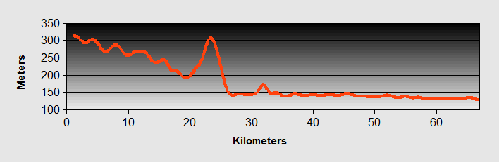
The Saar - Luxembourg to Trier Ride Profile
Ride Description
Today, for the first time there were blue skies and warm sunshine as we set off. We felt high as kites, this is what cycling in Europe in summer is supposed to be like.
We followed the cycle route from the campsite for a while but decided we would make faster progress on the main road. As it was Sunday there was very little traffic. We had coffee at Mondorf Les Bains which reminded us a little of Matlock Bath. Probably because, as we were sitting in the cafe, a huge group of motorcyclists cruised past. They were quickly followed by an equally huge group of Sunday road cyclists.

From there was another cycle route through a shady forest and onto the banks of the river Moselle. There are two cycle paths, one on each side of the river but the one on the east bank is traffic free.
Lots of other cyclists were enjoying the sunshine, mostly holiday makers on hired bikes but plenty of tourers as well. We made fast and easy progress along the river with its steep south facing sides covered in vineyards.
Arriving at Trier about 3.30pm we pitched the tent in the riverside campsite. It was only while checking in that we realised that we had ridden out of the site in Luxembourg that morning without paying! So now we were on Interpol's most wanted list. (They sent a bill to our home address).
There were a lot of other touring cyclists camping there. Later we rode into town to see the sites and have a beer.
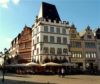
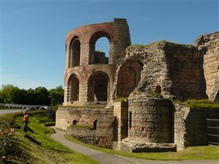
It is a lovely city with ancient Roman ruins and subsequently a popular tourist destination.
Back at the campsite we met a Swiss cycle touring couple who gave us a map for the next phase of our journey and suggested that we follow the Saar river instead of the Mosel and from Sarrebourg to take the canal route to Strasbourg.
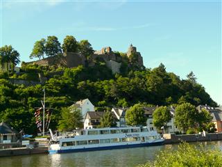
The Saar - Day 2 - Trier to Saarburg
- Distance 22.2km
- Max Elevation 180m
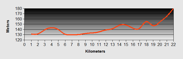
The Saar - Trier to Saarburg Ride Profile
Ride Description
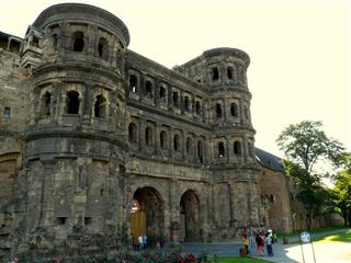
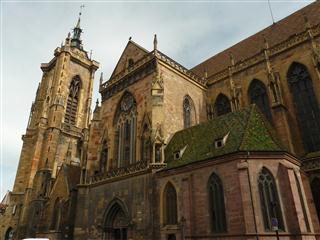
Before setting off we went back into town to visit more of the ancient architecture.
Specifically, the ruins of the Roman baths.....
....and the well preserved amphitheatre. Standing in the centre of the arena gave a real feeling of the atmosphere that would have existed when it was in use.
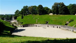
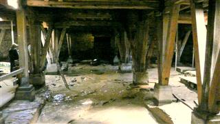
Under the arena is the area where the wild animals would have been kept before the contests. It can still be visited although while we were there workmen were shoring up the timbers that held the arena floor above.
It was almost 12-00 before we left town and promptly suffered our first puncture of the tour.
We retraced our steps along the banks of the Mosel to Konz and then turned onto the Saar river heading south east. The Saar is a smaller, less commercialised river which meant there were fewer cyclists as we rode in the warm afternoon sun.
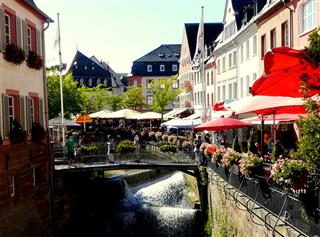
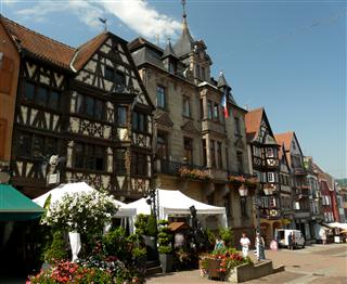
Saarburg was such a pretty town that although we had only covered 37km we decided to stay and explore.
The Saar - Day 3 - Saarburg to Saarlouis
- Distance 48.6km
- Max Elevation 250m

The Saar - Saarburg to Saarlouis Ride Profile
Ride Description
It was another hot and sunny day. The cycle route crossed to the other side of the river Saar which winds through high forested hills with rocky outcrops. At some points the cycle track was at the side of the road, but there was little traffic.
We passed a large quarry, which covered us and our bikes in a fine red dust and shortly after rode into Mettlach for a coffee stop.
The valley started to broaden out and became more industrialised as we got closer to Saarlouis. We followed the signposted cycle route towards the city and passed a camp site where we decided to stay for the night.
In the evening we cycled into the city which has well preserved city walls, but the center is modern and very little of its heritage remains. It does have a very nice pizzeria where we passed the evening.
The Saar - Day 4 - Saarlouis to Kirkastel
- Distance 74.4km
- Max Elevation 270m
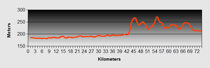
The Saar - Saarlouis to Kerkastel Ride Profile
Ride Description
A memorable day!
It all started out well. For E4.50 each we had a great breakfast of orange juice, meat and cheese platter , boiled egg, bread rolls, conserves , butter, coffee and fruit.
The route out of town followed the curve of the Saar river around a large market gardening area. The fields were planted with alternate bands of lettuce varieties in deep purples and greens. We had to dodge the sprinklers as we rode along the path.
Stopping for a cola at a bar by the river in Saarbrucken we met a Swiss couple (Andy and partner) from Basel. They had done lots of cycling in Europe and he gave us a lot of useful advice for our route through Switzerland and Italy. Andy runs a sports shop in Allschwin, just outside Basel.
We arrived in Sarreguemines at 13-00 and were surprised to find a boulangerie that was open at that time of day. It was so hot that we ate our lunch in the shade in a small park by the Saar river.
Tourist information opened, as usual, at 14-00 and we went in to find the nearest camp site. The lady told it was 15km away and although there was a cycle route she suggested that we follow the road for the fist section as it was less steep.
First we hit the supermarket to buy food for the evening. Leaving there we headed along the river Saar and found the suggested route. Battling up two steep hills on the road in the blazing heat we were cursing the tourist information lady. As soon as possible we turned onto the cycle route which was much flatter and in the shade. After 15km in the heat we arrived at the camp site, only to find that we had lost our wallet somewhere on the way from the supermarket.
Without any cash we convinced the receptionist to let us pitch the tent and then find an ATM. A quick ride around the site gave us an uneasy feeling about it and we didn't feel that our gear would be safe there if we went off site. It was on the side of a lake and teeming with day trippers, mostly local teenagers with bags full of beers.
Despite the heat, the tiredness and our fear of our bank account being emptied of cash, we set off again to ride another 12km to the nearest town and back on the river Saar, with an ATM. We still had Karen's bank card. With money in our pocket we sat at a local bar with a long cool lager as we contemplated our options.
On the next table was a group of locals and we told them about our problem. A problem shared is a problem solved. Christophe immediately rang the supermarket. They had not had anything handed in. Next he rang the police station and to our astonishment it had been handed in there. It was intact even including the 200+ euros in cash.
Christophe drove us back to Sarreguemines police station to collect it and then loaded all our gear into his van and took us to the nearest campsite at Kerkastel which was much better than the one we had originally been to. What a hero!
The Saar - Day 5 - Kerkastel to Sarrebourg
- Distance 33.5km
- Max Elevation 320m
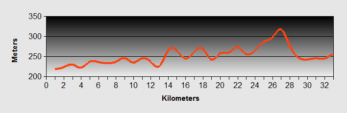
The Saar - Kerkastel to Sarrebourg Ride Profile
Ride Description
The Saar valley cycle route ends at Saraguemines. Another route heads south west on the Canal des Houileres but we wanted to continue up the Saar valley. This meant we were on the road, through lovely rolling countryside. The first section, to Saar-Union was on quiet lanes but from there on the D roads it was a bit more unsettling. Not too much traffic but several fast lorries that cut us up. Again the temperature was high with no clouds in the sky and we wanted to end the ride by lunchtime.
Approaching Sarrebourg at about 1pm there was a small restaurant at the roadside with a shady terrace and we decided to have their menu de jour. Two lovely courses and a glass of beer in the relative cool shade was very relaxing and just a couple of kilometers into Sarrebourg afterwards.
There was no campsite near so we booked into an Auberge and had another meal out in the evening. A complete 'blow the budget' day. It was so hot that night that we almost wished we were in the tent.
The Saar - Day 6 - Sarrebourg to Strasbourg
- Distance 76.7km
- Max Elevation 350m
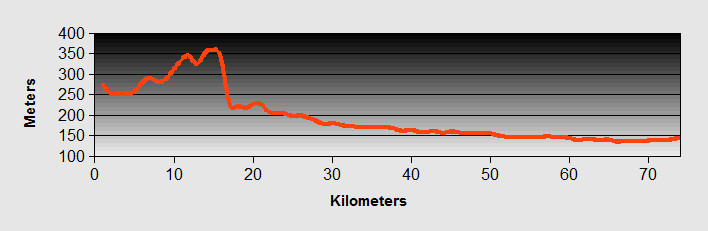
The Saar - Sarrebourg to Strasbourg Ride Profile
Ride Description
Today we did not know quite what to expect from our ride. We knew we had to find a route out of Sarrebourg and onto the Canal de la Marne au Rhin. This canal runs west to east across the southern part of the Vosges area and the map showed a lot of contours. We knew there was a boat incline lift and many locks so we expected quite a hard climb.
We had been given some route instructions by the girl at Tourist Information but the Auberge owner gave us a much better route, avoiding the busy roads around Sarrebourg. We got an early start and it was lovely riding along the quiet roads in the cool morning air. We found the canal and rode close to it on a unsurfaced road through a shady forest and up a gentle gradient. That turned out to be the only climbing of the day.
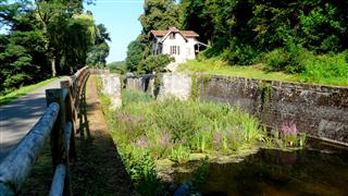
After the village of Arviller we saw a bike route direction sign to the left and found ourselves on the old, disused section of the canal. In 1965 a new boat lift was built at St Louis, replacing the 17 locks on this section of the canal. The whole section if now derelict, with only a couple of the old lock-keeper's house now occupied and the lock gates rotting. But the partly drained canal is now a haven for wildlife with huge fish, marsh plants, insects and birds in abundance. On each side are high forested hills and the route is shaded and hardly used and, miracle of miracles, it was all downhill!
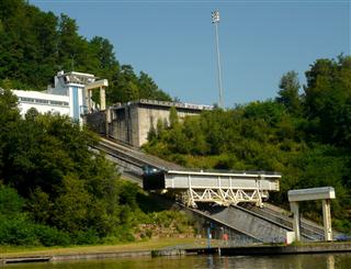
On reaching the new section of the canal we took a 3km detour to see the 'Plan D'Incline' which is the boat lift. After riding up a steep hill and climbing up a heap of steps we realised that to get into the visitor centre was going to cost 4 euro each so we turned round and went back down the road where there was a very good view of the lift for free.
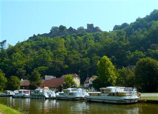
The route continues along the canal, dropping through a series of 37 more locks to reach the Rhine at Strasbourg. We stopped at the pretty town of Lutzelbourg with it's hilltop castle for coffee.
By lunchtime we arrived at the equally charming town of Saverne. To save money after yesterday's extravagances we brought sandwiches and sat at the side of the canal for a picnic.
We pushed on along the canal as the terrain flattened out and dark clouds started rolling in. It was only a short heavy shower so we just sheltered under a bridge. The only problem was that twice the towpath was closed as they are upgrading the East European TGV track. The signposting for these detours was poor and we had to navigate our way round several villages.
Coming into Strasbourg along the canal was much simpler than we expected. This really is a city that's tuned into cycling. The whole centre is virtually traffic free and nowhere is out of bounds for cyclists. We wove our way through the crowds of tourists and found the signposted cycle route out to the east to the campsite at Montane Verte.
That evening we waited with bated breath to watch the opening ceremony of the Olympics. We were joined by Australians, Americans and French. We all struggled to understand what was going on as, of course, the commentary was in french, and we found ourselves having to explain lots of things like who Brunel was, what pearly kings and queens were, what GOSH meant etc. They all lost interest and wandered off to bed after a while. We found the whole thing quite embarrassing.
Day off - Strasbourg
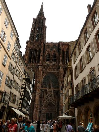
We rode into Strasbourg on the bikes. We loved the place as it was full of history and atmosphere. The cathedral has to be one of the most intricate of designs that we have seen.
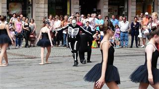
In the Cathedral square was the Kaleidoscope dance troop from Whitley Bay in the UK. They were performing a mixture of traditional English, Scottish and Irish folk as well as modern dance. In the middle of their performance the heavens opened and the audience dashed for cover, into the cathedral and nearby shops and restaurants. We opted for the latter as it was near lunch time. The dance troop carried on regardless in great British style.
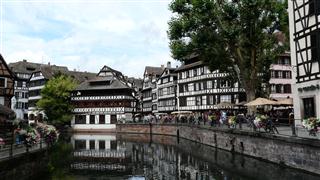
Strasbourg is a cyclists haven with most of the pedestrian areas of the city as well as many cycle lanes and one way streets open to cyclists. Signage is really good and it is easy to find your way around using the cycle lanes. Petite France is a tourist hotspot, but it is easy to see why. Finally we headed back to the camp site, dinner and a gin and tonic session with Darcy and Rachel, a young couple from Tasmania that we had met the day before.
The Saar - Day 7 - Strasbourg to Colmar
- Distance 79.9km
- Max Elevation 189m
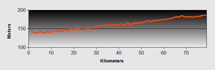
The Saar - Strasbourg to Colmar Ride Profile
Ride Description
We found our way out of Strasbourg along the cycle routes by following the signs from one suburb to the next, finally finding our way onto the Rhine-Rhone Canal.
After several kilometers we decided that we were bored of the canal, despite its lovely leafy banks and turned off to ride along the minor roads of the Rhine valley. This took us through many pretty villages with lots of timber frame houses, dating from the 1700s and painted in rainbow colours. As it was Sunday, all the shops and bars that we came across were closed and we started to lose hope of finding food. Luckily we happened across an Asian supermarket that was "open all hours" and managed to buy lunch which we ate by the side of the river a little further down the road.
As we ate lots of local people were walking past us going to and from a large car boot sale in the forest. They all kept wishing us "Bon Appetite", which got a bit wearing after a while.
In the afternoon we continued riding through acre after acre of maize fields which grew over 2 meters high and spoiled our views. It became very tedious as there was nothing else there. No insects, no wild flowers just maize. We went past a couple of dairy farms, but the cows which should have been out in the fields were shut up in sheds. There was no pasture only maize and most likely all GM to boot. It just seemed all wrong.
By five o'clock we arrived at a nice camp site by the side of the river Ill in Horbourg-Wihr near the town of Colmar and enjoyed a warm evening and dinner by the side of the river.
The Saar - Day 8 - Colmar to Basel
- Distance 83km
- Max Elevation 293m
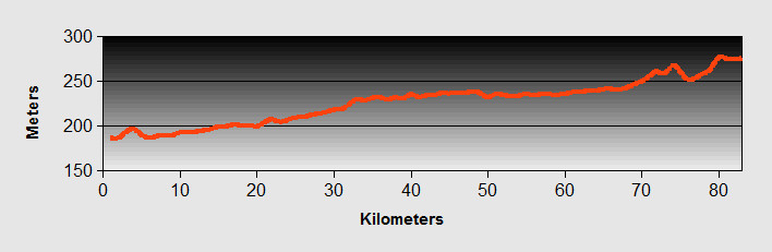
The Saar - Colmar to Basel Ride Profile
Ride Description
As we wanted to see Colmar we left early and found a nice little bar in the center serving breakfast and spent the next hour or so riding through the lovely town.
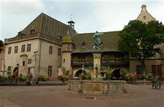
Yet another "little Venice" evolving around the canal.
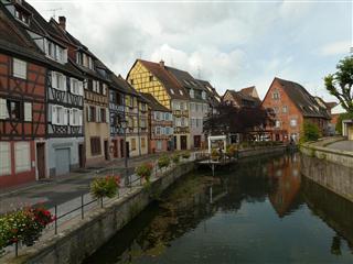
The cathedral was unusual in that it was built in a very "warm" stone of multiple colouring, which made a change from the mono-coloured stone of most cathedrals we had seen in our travels.
Our route continued along the back roads of the Rhine valley, through more pretty villages, tedious maize and into a strong southerly headwind.
After about 30km we came into the Foret de la Harth which has a cycle track running all the way through its centre, until we turned back onto the canal just before Rosenau. The route swapped from bank to bank a couple of times and finally we came into St Louis with its pharmaceutical and chemical complex on the Rhine to the west of Basel. We crossed over the border into Switzerland without event. It was then a straightforward ride through the suburbs into the busy center of the city.
We enquired after accommodation at tourist information and were shocked at the prices. Even a hostel was about 90 pounds per night for the two of us. In the end we realised that we could only afford to camp for 23 pounds per night and 8km out of town. To get over the shock we sat at a city center bar and ordered two large beers. We were hit again by an aftershock when we got the bill of 15 pounds for two beers. Next it was time to do some shopping. The aftershocks continued with the price of the food. By now it was clear that we had to get through Switzerland as quickly as we could. It is just too expensive here.
The camp site was clean and had everything we needed, but it was right next to the tennis courts which had floodlights. The tennis continued until 11-00 at night and there was some sort of party going on, so it was midnight before we were able to get to sleep.
Day Off - Basel
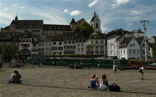
Although it was costly we needed to see the city and for the first time we left the bikes and took the tram. Basel is like many modern European cities. It has its tram network and plenty of bicycle lanes. It has its architecture, cathedral and antiquated buildings. It also had, apparently a great night life and there was no shortage of money washing around the place, (we just didn't have any of it). But somehow it just didn't do it for us. We can't put our finger on it. Maybe it was just the high prices, but honestly we were not sorry to leave.
It being the 31st July it was Switzerland's national day so that night there were lots of celebrations and a fantastic firework display over the river. The constant bangs of fireworks continued until about 1am so little sleep again.
The next stage of our ride took us over the Alps via the Gotthard pass from Basel to Lake Como in Northern Italy
New! Comments
Have your say about what you just read! Leave me a comment in the box below.